Showing 3158 items matching "south west"
-
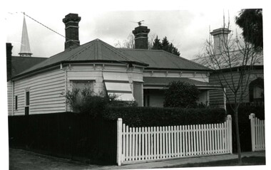
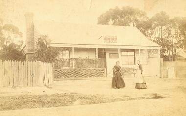
 City of Moorabbin Historical Society (Operating the Box Cottage Museum)
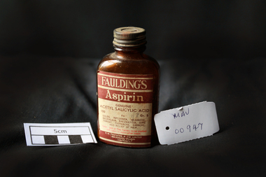
Manufactured Glass, brown bottle 'Fauldings Aspirin', c1950
Francis Hardy Faulding 1816 – 1868 arrived in Sydney 1842. He was a Surgeon on the emigrant ship Nabob. 1845 Francis Hardy Faulding opened his first pharmacy at 5 Rundle Street in Adelaide and the business prospered. In 1867 he formed F.H Faulding & Co with Luther Scammel. as wholesale druggists and manufacturing chemists. Two of the Faulding company's major innovations were the development of a process for distillation of eucalyptus oil, and the development of the test for determining the eucalyptol content of the oil. Faulding's success was founded on eucalyptus oil, which formed the basis of an antiseptic marketed as "Solyptol" In 1868 Francis Hardy Faulding died, aged 52 at his suburban Glen Osmond home in Adelaide. Scammel’s two sons took over the business in 1888 and in 1890 the Company expanded to West Australia, then Sydney, Brisbane and finally, in 1924, Faulding began operations in Exhibition Street, Melbourne, eventually adding wholesale activities. 1986 With a presence in every city, from Darwin to Tasmania. Faulding becomes a truly national company. 2008 Zuelllig Group takes control Focusing solely on pharmaceutical wholesaling and distribution, Hong Kong based Zuelllig Group takes over control of Symbion Pharmacy Services. 2008 Symbion Pharmacy Services exceeds $3 billion with one of the country's largest networks of warehousing systems and service A brown glass, bottle with a metal screw top containing ‘Faulding's Aspirin’ tabletsFront label : FAULDINGS / ASPIRIN / GENUINE / ACETYL SALICYLIC ACID / 100 Gr 5 / for / Colds, .............. / DOSE ........... / F.H.FAULDING & CO LTD / MANUFACTURING CHEMISTS / AUSTRALIApharmacy, medicines, faulding f.h., scammell luther, faulding's aspirin, glassware, bottles, moorabbin, bentleigh, cheltenham, antiseptics, analgesics, pharmaceuticals, south australia, ss nabob, f.h.faulding & co. -
 Glenelg Shire Council Cultural Collection
Postcard - Postcard - Bentinck Street, Portland Victoria, n.d
Postcard, hand coloured. View of west side of Bentinck St. looking south, includes Gordon and Mac's hotelsFront: 'THE SOUTHERN CROSS SERIES 10800' copyright' 'BENTINCK STREET PORTLAND' Black print, bottom margin -
 Glenelg Shire Council Cultural Collection
Photograph - Photograph - Julia Street, Portland, n.d
Displayed at History House.Black and white photo. Looking west to east, Julia Street. First 2 buildings have verandahs and 1 chimney each. Double storey, stone building, 4 upstairs windows, 2 chimneys. Small building between 2 double storey buildings. Double storey blue stone with verandah. Small building. 4 double storey buildings.Front: Portland-Julia Street, Looking west to east. Back: State Library of South Australia. Photographic Section Reproduction prohibited except with the permission of the copyright holder. Order No. A/6493.street scene, portland street scene, photography -
Glenelg Shire Council Cultural Collection
Photograph - Sheet of 12 contact prints - Various historic Portland buildings and Landmarks, c. 1970
Sheet of 12 contact prints of rephotographed photographs. Measurements (a) (e)-(h) (j-i)(b) 3.7 x 55 x 3.7 Framed 5.2 x 44.5 x 4 (a) Looking south across beach at Dutton Way (b) S.S. 'Eumeralla' (c) Construction of railway pier (d) Jackass Fern Gully (e) 'Kingsley' (f) Portland Show (g) North side Julia Street looking west Bank of Australiasia (h) Henty Street looking east from Percy Street (i) Old Post Office (j) All Saints Catholic Church (k) View from Henty Street - old Town Hall (l) Opening 3rd BathsFront: (a) 'Dutton Way 1900 (b) 'S.S. Eumeralla' (c) Construction of Railway Pier (f) Portland Show (h) Henty Street, Portland (i) (B) -
 Eltham District Historical Society Inc
Negative - Photograph, Tom Prior, Langlands Bridge, Eltham, c.1900
It is noted in the Reynolds Prior collection (Ivy Reynolds) as the first bridge in Eltham however given the current state of knowledge, this is considered unlikely and there is no other supporting source. John Hunter Langlands, owner of the farm known as ‘Ihurst’ on the west side of Diamond Creek to the south of John Wright Murray’s land, died in 1907. In 1909 his land was subdivided into 100 lots to become the ‘Glen Park Estate’. It is possible that the bidge may have crossed the Diamond Creek to Langland's land along the original alignment of Glen Park Road which used to run between present day Progress Road and Coleman Crescent. SEPP Source (c.1970): Mrs. E.R. Reynolds, Thompson Crescent, Research The Reynolds family were early settlers in Research. The Reynolds/ Prior collection of photographs were taken by Tom Prior, the maternal uncle of Ivy Reynolds, around 1900 and the 60 photos in the album give a fine overview of many of the landmarks of Research and Eltham over 100 years ago. lvy lived in the family home for many years at 106 Thompson Cres Research. Ivy's father, Ernst Richard Reynolds and grandfather, Richard Reynolds, lived at the same address. Ivy's father Richard worked for Mr. Trail on his property in Research. Reynolds Road is named after the family. Mr Tom Prior (wife Eva) worked at the Melbourne zoo. He was very innovative and made his own camera, using the black cloth hood to exclude the light. The photographs are a reminder of the rural nature of Research and Eltham and its rich heritage. This photo forms part of a collection of photographs gathered by the Shire of Eltham for their centenary project book,"Pioneers and Painters: 100 years of the Shire of Eltham" by Alan Marshall (1971). The collection of over 500 images is held in partnership between Eltham District Historical Society and Yarra Plenty Regional Library (Eltham Library) and is now formally known as the 'The Shire of Eltham Pioneers Photograph Collection.' It is significant in being the first community sourced collection representing the places and people of the Shire's first one hundred years.Digital image 4 x 5 inch B&W Neg B&W printsepp, shire of eltham pioneers photograph collection, eltham, langlands bridge, reynolds prior collection, bridge, john hunter langlands -
 Eltham District Historical Society Inc
Negative - Photograph, George W. Bell, Excavation of site for new Eltham Shire Office building, 895 Main Road, Eltham, 1964
Black and white photograph of bulldozer excavating the former Shillinglaw Cottage site for new Shire Offices. 'Shillinglaw Trees' in background. The cottage and land were purchased by the Shire of Eltham as the site for a new shire office building. The cottage was destined for demolition but members of the community concerned at losing one of the areas earliest buildings (built c.1859) initiated a fund-raising campaign to save the cottage. In 1964 the cottage was dis-assembled, all the bricks numbered and reassembled several hundred meters to the south on a site between the Gahan house and the Eltham Railway Trestle Bridge (present-day Panther Place), which became known as the Eltham Common. The new shire offices at 895 Main Road were opened in 1965. Following the Kennett Government amalgamation of local government areas in 1994, the Shire of Eltham ceased to exist, and a new Shire of Nillumbik was created 15 December 1994 from the former Eltham shire and parts of the Diamond Valley shire. The former West Riding which included parts of Montmorency, Lower Plenty and Briar Hill were ceded to the new City of Banyule. Commissioners were appointed for several years and the new Council occupied the former offices of the Shire of Diamond Valley in Greensborough. The former Eltham Shire offices remained vacant until August 1996 the Commissioners suddenly elected to have the former Shire offices demolished immediately and the site has remained vacant ever since. It was not until 1997 before the community was allowed to democratically elect new Councillors to represent them. This photo forms part of a collection of photographs gathered by the Shire of Eltham for their centenary project book,"Pioneers and Painters: 100 years of the Shire of Eltham" by Alan Marshall (1971). The collection of over 500 images is held in partnership between Eltham District Historical Society and Yarra Plenty Regional Library (Eltham Library) and is now formally known as the 'The Shire of Eltham Pioneers Photograph Collection.' It is significant in being the first community sourced collection representing the places and people of the Shire's first one hundred years.Digital image 4 x 5 inch B&W Negeltham, eltham shire office, excavation, george w. bell collection, main road, municipal offices, shillinglaw cottage, shillinglaw trees, shire of eltham pioneers photograph collection, shire offices, significant tree -
 Kiewa Valley Historical Society
Black and white photograph of Surveyor's Camp, 1938, Kiewa River and surveyor's Camp 25/8/38, 25/08/1938
Surveying under the prevailing conditions at this time was an arduous and demanding task. There were no roads beyond Tawonga and access was by bridle tracks, on foot or horseback. This camp was to provide accommodation to those men who were surveying the road from South Tawonga to the Bogong High Plains which was commenced in April, 1938. The actual work was undertaken by the Country Roads Board, on behalf of the State Electricity Commission, using three Caterpillar diesel crawler tractors equipped with Kay Bruneriei (Brunner) lhydraulically operated trailbuilders (angle dozers)This photograph shows the primitive living conditions that were endured by those carrying out the initial field investigations and surveys for the Kiewa Hydro Electric Scheme. It is possibly one of the few photographs in existence of this camp and of the very rustic timber foot bridge across the West Kiewa river. It has been taken from approx. 100m up Simmonds Creek Road. A black and white photograph showing a small, timber foot bridge across the West Kiewa River. There is a man standing on the bridge and two small huts on the far side of the river, against a backdrop of Mt. Beauty and Mt. Bogong.At the top of the photograph, handwritten in black ink is the inscription "Kiewa River and Surveyor's Camp 25/8/38". The number 4 is stamped towards the right upper corner. On the back, in a circle, about 1.3cm in diameter, are the words "Kodak Print". The word "Velox" is faintly discernible on the back as well.surveyor, tawonga, west kiewa river, bridge, camp, secv -
 Eltham District Historical Society Inc
Photograph, Looking south across to the shopping centre from the west side of Main Road, Eltham, February 1968, Feb 1968
Shows Bryant Motors beside Railway Station.In February 1968 an unknown person took a series of photos from the Eltham Hotel at Pitt Street heading north along Main Road through the shopping centre to just north of Elsa Court covering the length of the section of Main Road which was duplicated shortly thereafter. Shows the condition and environment of the streesscape of Main Road, Eltham immediately prior to the duplication between Pitt Street and Elsa Court through the shopping centre. Also shows a number of shops and businesses that operated at that time.Black and white photographduplication, eltham, main road, luck street, bryant motors, buses -
Eltham District Historical Society Inc
Newspaper - Newsclipping, Nillumbik Mail, "A Memorial Avenue of Honour", A Journey in Time: A column about Nillumbik's history, Nillumbik Mail, 24 May 2000, p4, 2000
Main Road, Eltham, south from Brougham Street to Dalton Street, c.1911 View looking down Policeman’s Hill on Maria Street (Main Road) from near Brougham Street towards Dalton Street, site of the Avenue of Honour established in 1916-1917 in memory of the soldiers who served in the First World War, 1914-1918. At the bottom of the hill on the right is White Cloud Cottage, home of the Jarrold family, three women standing out front observing the photographer. The road passes over a culvert which runs to the west in front of the cottage. The cottage was originally located closer to the Diamond Creek but was subject to flooding. It was dragged by horse to the present site shown, which was chosen for the higher ground that had been created as a result of land fill being deposited here from the quarry further around the bend on Main Road (site of present-day Eltham Primary School carpark) where the stone had been quarried for building the State School in Dalton Street. Immediately at the end of the straight section of the main road can be seen the gas streetlamp in front of the Jarrold home and the pond at the bottom of Dalton Street. The cottage had previously been rented for use as a Police Station / residence prior to the building of the permanent police house and station at the corner of Maria and Brougham streets in 1859. At the time of collection of photos for the centenary of the Shire of Eltham (1971) the cottage was owned by the Skipper family and remains in the family to present day (2021). On the left is the Grant house on the corner of Main Road and Dalton Street now the present-day site of Eltham Clinic. Photographer: J.H. Clark John Henry Clark was the youngest of three boys born to William Henry Clark (1823-1877) and Maria White (1843-1914). He and his brothers, William Charles Clark (1872-1945), Clement Kent Clark (1874-1912) operated a photography business (Clark Bros.) from 25 Thomas Street, Windsor near Prahran during the period c.1894 to 1914. Following death of Clement in September 1912 and their mother in 1914, the Clark Bros business appears to have dissolved, the premises demolished, and a new house was under construction in 1915. John set up business independently in 1914 operating out of 29 Moor Street, Fitzroy where he is registered in the 1914 and 1915 Electoral Rolls. By 1916 John had relocated to Eltham where he continued his practice as a photographer and took many of the early images around the district of Little Eltham. Around 1930 John changed professions and opened a small cobbler's shop in 1931 near the pond opposite Dalton Street adjacent to the Jarrold family cottage. He never married and continued his profession as a bootmaker from this little shop, maintaining a close relationship with Mrs Jarrold for the rest of their lives. His bootmaker shop remains today beside the Whitecloud cottage and is one of only three remaining shops in the area from the early 20th century. There are a couple of images of Eltham taken by Clark Bros. in the Eltham District Historical Society collection, one such example being Hunniford’s Post Office with Miss Anne Hunniford out front (EDHS_00140 - marked on the back of the print, Clark Bros., 25 Thomas St. Windsor), which would date this image between c.1894 and 1914. Other early images of Eltham taken by John Henry Clark are marked on the face “J. H. Clark Photo” and it is assumed these are dated between 1914 and 1930. It is noted that the Grant of Probate for John H Clark of Eltham South dated 5 April !957 (513/387) records his occupation as "X Photographer".Newsprint pageNillumbik Mail publication details; Edition 4, 24 May 2000, p4dalton street, avenue of honour, eltham clinic, gas lamp, grant house, j.h. clark photo, jarrold cottage, jarrold family, main road, shire of eltham pioneers photograph collection, white cloud cottage -
 Eltham District Historical Society Inc
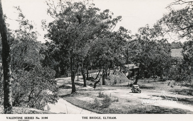
Postcard - Photograph, The Rose Stereograph Company, The Bridge, Eltham, c.1939
Looking west across the Main Road Bridge over the Diamond Creek at Eltham, c.1939. The car in the foreground, possibly the photographer's, is a Ford Model C Ten built by Ford UK between 1934 and 1937. The Model C was released in Australia in 1935. The Ford Model C Ten is a car that was built by Ford UK between 1934 and 1937. The Model C was released in Australia in 1935 https://en.wikipedia.org/wiki/Ford_Model_C_TenPostcardValentine Series No.3196diamond creek (creek), ford model c ten, main road bridge, postcard, valentine series postcard, bridge, cars, eltham, eltham south, main road, motor vehicles, rose stereograph, rose stereograph company -
 Warrnambool and District Historical Society Inc.
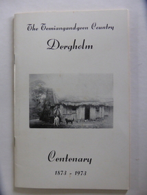
Booklet, The Temiangandeen Country Dergholm, 1973
This booklet gives information on the settlement of Dergholm at the time of the centenary of its founding, 1973. The origin of the name Dergholm is unclear but it may have Irish connections. Europeans came to the area in the 1840s and 50s but it was not until the 1870s that the town was surveyed. Dergholm is in the far west of Victoria 334 kilometres from Melbourne and nearby is Dergholm State Park established in 1982. The booklet was produced for the Centenary Back to Dergholm Committee and the local centenary celebrations. This book is of some interest as it provides information on Dergholm, a settlement in the far west of Western Victoria. This is a soft cover booklet of 52 pages by Alistair Roper. It has a cream-coloured cover with a black and white photograph of early Dergholm on the front cover (Edward Quinn’s house). The booklet has printed material - a President’s Message, an Author’s Note, Acknowledgements, Contents, information on the Dergholm area, including a list of local birds, and References. There are several black and white photographs of the area and its people. The book is stapled. Front Cover: ‘The Temiangandgeen Country, Dergholm Centenary, 1873-1973’dergholm victoria, alistair roper, history of western district of victoria -
 Warrnambool and District Historical Society Inc.
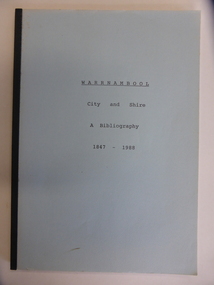
Booklet, City & Shire Bibliography 1847-1988, 1989
... or at the South West College of TAFE in Timor Street Warrnambool ...This 1989 booklet contains lists of publications connected with Warrnambool and District and it was compiled by W. Pinson and M. Johnstone. The publications listed were ones held at the time by the Warrnambool branch of the Corangamite Regional Library Service and the Warrnambool Institute of Advanced Education library. The publications are listed under the headings of Community, Environment, Heritage, Industry and Tourism. Although the information in this book is well out-of-date, it may be of interest to researchers today. The publications may still be available at the Warrnambool Library or at the South West College of TAFE in Timor Street Warrnambool or at Deakin University in Warrnambool. This is a soft cover booklet of 162 pages. It has a pale blue cover and is bound with black tape. It has a map of Warrnambool city, an Introduction, an alphabetical listing of publications concerning Warrnambool City and Shire and an Index. It has some photocopied black and white photographs of Warrnambool (untitled) and a reproduction of the front cover of Osburne’s History of Warrnambool.Front Cover: ‘Warrnambool City and Shire’ ‘A Bibliography 1847-1988’ history of warrnambool, history of western district, warrnambool library -
 Warrnambool and District Historical Society Inc.
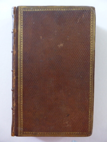
Book, The Lady of the Lake, 1810
This book is an 1810 third edition copy of Walter Scott’s poem, ‘The Lady of the Lake’. It is notable for its illustrations of the drawings of Richard Westall (1765-1836), an English painter and illustrator and Queen Victoria’s drawing master. Westall is best-known for his portraits of Lord Byron. There is no information available on the original owner, the Reverend Matthew West. Tis book is important because: 1. It is an 1810 edition and of antiquarian interest 2. It belonged to Louie Mack, the cousin of Sir Ronald Mack, an important Warrnambool Parliamentarian. Miss Mack was well-known in the Warrnambool area as the Secretary of the Warrnambool Technical School in the 1930s, 40s and 50s. The Macks were prominent early settlers in the Warrnambool area. This is a hard cover leather bound book of 433 pages (poem, ‘The Lady of the Lake’ by Walter Scott). The cover is brown leather with a gold ornamental border. The inside cover has a tan and blue mottled pattern. The book has illustrations with engravings from the designs of Richard Westall. The illustrations have a piece of tissue paper in front of them. The first page has a stamp of the Warrnambool & District Historical Society and there is a loose sheet indicating that the book was published in 1810 and that it belonged to Miss L.A. Mack.‘The Revd. Matthew West, Vicar’s Hall, Clane’. sir walter scott, richard westall, louie mack, history of warrnambool, rev. matthew west -
 Victoria Police Museum
Police Stations (Apsley)
Apsley is a small town in Victoria, Australia. It is on the Wimmera Highway, in the Shire of West Wimmera, 420 kilometres north-west of Melbourne, and 7 kilometres east of the South Australian border. Apsley Police Station opened on 29th November 1884 and was originally located in Wallace Street. It was staffed by one Foot Constable (motor cycle). The building was described, in 1930, as a four-roomed dwelling with an iron roof, set on a quarter of an acre of land. There was a bathroom, a WC, wash-house and a garage. An office adjoined the house and there was also a lockup. The station moved several times until the mid 1960s when a timber residence was moved onto land adjacent to the Post Office. The building is believed to have been transported from the Stawell area. Apsley is one of a handful of one-man police stations in Victoria and its current location, including residence, is at 19 Splatt Street. Apsley was in the Western District when it opened, then in "L" (Wimmera) District from January 1948 and "M" (Highlands/Wimmera) District from March 1990. 4 black & white photos, 1965 3 colour photos, 1987police stations; apsley police station -
 Victoria Police Museum
Police Stations (Armadale)
Armadale is an inner suburb of Melbourne, Victoria, Australia, 7 km south-east of Melbourne's Central Business District, located within the City of Stonnington local government area. Armadale Police Station opened, in Melbourne Police District, on 11 May 1885. Its original location is unknown, but in 1890 it is listed in the Sands & McDougall directory as at 295 Hight Street. From 1985-1920 it was located at 20/22 Auburn Grove, 1925-1930 at 769 High Street and 1935-1946 at 3 Cheel Street. The station closed on 28 January 1946. The sub-division east of Orrong Rd was incorporated into Malvern Sub-district and west of Orrong Road into Prahran Sub-district. In a special 1930 issue of the Victoria Police Gazette the Armadale Police Station was described as a seven-roomed brick dwelling with a tiled roof on land measuring 127' x 104' x 98'. There was also a bathroom and W.C., a wash-house, office, and a lock-up (one cell). This is probably a description of the Cheel Street police station. It was staffed by one senior constable and three foot constables.12 photographs comprising 8 coloured images and 4 black and white images 1 sketch plan of Old Armadale Police Stationpolice stations; armadale police station -
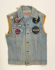 Australian Queer Archives
Uniform - Textiles, Owen Huckel's Roo BC overlay, c.1970s-1980s, c1975
This motorcycle club overlay belonged to former Roo BC [Roo Bike Club] President Owen Huckel, and dates from the mid 1970s. Prior to joining Roo BC, Huckel was a member and President of Australia's first gay motorcycle club, South Pacific Motor Club or SPMC, established in 1970. Among the Papers of Noel Lewington held by the Australian Queer Archives are two large photograph albums compiled by Huckel documenting his involvement in SPMC and Roo BC, including one which documents a trip to the USA in 1972-1973, comprising 366 photographs, maps, and ephemera documenting club runs with many west coast clubs. Sleeveless denim jacket, with yellow ribbon trim around the sleeve holes, with small patches and a metal badge on the chest, and a large back patch on the back.gay, motorcycle club -
 Warrnambool and District Historical Society Inc.
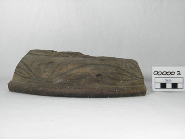
Souvenir - Shipwreck item, Falls of Halladale, 1886
... shipwrecks along the South West coast of Victoria. There are a number ...The Falls of Halladale was a four-masted iron-hulled barque built for the long-distance bulk carrier trade. In dense fog on the night of 14 November 1908 she was sailed onto rocks off Peterborough due to a navigational error. The 29 crew abandoned ship safely and reached shore by boat. The ship was left foundering with sails unfurled. For weeks afterwards large crowds gathered to view the ship as she gradually broke up and sank in the shallow water. Shortly after the accident the ship's master, Captain Thomson, faced a Court of Marine Enquiry in Melbourne. He was found guilty of a gross act of misconduct, having carelessly navigated the ship, neglected to take proper soundings and failing to place the ship on a port tack before it became too late to avoid shipwreck. Thomson's punishment included a small fine and six months suspension of his Master's Certificate of Competency. The hull lies on its starboard side about 300 metres off-shore in 3-15 metres of water. The original cargo included 56,763 roofing slates and coils of barbed wire. 22,000 slates were salvaged in the 1980s and used as roofing at Flagstaff Hill Maritime Village, Warrnambool.This item has historical significance as it came from one of the known shipwrecks along the South West coast of Victoria. There are a number of photographs of the wreck as it founded on the rock and hence is an image with which many people are familiar. Curved piece of timber with flat base from the wreck of the ship Falls of Halladale. Inside is recessed with slight ledge near back. A chunk of timber is missing on the top. The face has swirled carvings with leaf and seed design and base curved to the edge.Hand painted in red paint on inside bottom edge 'PETERBOROUGH'. Hand painted in white paint on bottom 'FALLS OF HALLADALE/WRECKED/PETERBOROUGH/VIC/NOV. 1908'melbourne, shipwrecks, flagstaff hill maritime village, warrnambool, falls of halladale, barques, peterborough victoria, roofing slates, captain thomson, thomson, court of marine enquiry -
 Warrnambool and District Historical Society Inc.
Programme - Celtic Concert presented by Warrnambool & District Pipes & Drums Inc, 2013
... Scottish people settled in the South West of Victoria from the 1840 ...The Warrnambool Pipe was started around 1906 under the tuition of Simon Fraser and his sons. It has operated in various forms for most of that time. A ladies band was formed in 1951 and the two bands amalgamated in 1974. They celebrated their centenary in 2007. Many Scottish people settled in the South West of Victoria from the 1840’s onward and brought with them many of their traditions. The Warrnambool pipe band is one aspect of Scottish traditions which have been continued in this region, including a Caledonian Society and Scottish dancing In one paragraph state what is significant, the type of significance it holds, and why it is significantFour pages with title Celtic Concert in dark blue on muted coloured cover with performance details and dates of performance in the middle with major sponsors within box at bottom of page. Inside two pages contains details of performers and the concert program. The back page contains a list of sponsors.Deakin Worldly, Warrnambool, RSL, Victoria Police, Police band, Victoria Pipe Band, warrnambool, warrnambool pipe band, simon fraser, warrnambool ladies band -
 Warrnambool and District Historical Society Inc.
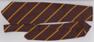
Textile - Warrnambool Primary School 1743 Tie, Circa 1950’s
Warrnambool State School, No, 1743 was opened in 1876. The site in Jamieson St was easy to access from the surrounding areas of Belfast, Woodford, and Allansford roads. It was the main school in Warrnambool, before the development of Primary schools at East and West Warrnambool. A large part of Warrnambool’s children have attended this school over the 140 years it has been in existence.A common item with which a large number of Warrnambool residents would identify. Brown woven woollen tie with diagonal yellow stripes. White tag with black and red writing sewn into back seam.Tee- Dee, pure wool, school and college wear. warrnambool, warrnambool jamieson street primary school, no 1743, school tie, warrnambool primary school -
 Warrnambool and District Historical Society Inc.
Book, Alone in West Africa by Mary Gaunt, Printed 1912
“Alone in West Africa” is one of a number of works written by Mary Gaunt. Her other works include, A Woman in China, The End of the Earth, Kirkhams Find, The Moving Finger and Deadman’s. Mary was born at Indigo near Chiltern in 1862 and lived for many years in Ballarat where her father W.H. Gaunt was gold commissioner and later a judge. The original Gaunt family home was converted into St Patrick’s College. She married Dr Lindsay Miller and moved to Warrnambool and after his death in 1899 she embarked on her travels which took her to many parts of the world. She died in Cannes, France in January 1942. Mary Gaunt wrote over 25 novels, numerous travel books and many stories and articles. She had a strong link with Warrnambool and details of the district are included among her writings. She also wrote regularly in the early 1900’s for the Times in London on women issues. She was an independent thinker and worker. Apart from the text of “Alone in West Africa,” the work contains 97 black and white photographs which Mary had taken and developed herself. These photos are a significant view of aspects of life in Africa at that timeDark blue cover with gold text. Title, “Alone in West Africa” with sketch of two children in the centre, with Mary Gaunt underneath. The back cover has an embossed letter “L”. Inside the front cover is a rough sketch of the author’s route of the French Ivory Coast. It contains a number of black and white plates and index. 399 pages.T Werner Laurie on bottom of spine. Black and white photograph of author with autograph underneath. T Werner Laurie Clifford’s Inn London. Acknowledgements included in the dedication , Sir Charles Lucas, Sir George Denton, Elder Dempster and Co. Messrs. Swanzy and Co.,gaunt, mary gaunt, alone in west africa, french ivory coast 1912 -
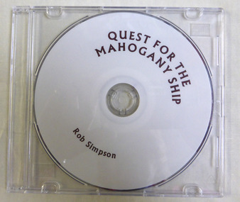 Warrnambool and District Historical Society Inc.
Education kit - CD, Quest for the Mahogany Ship, 2014
This CD relates the story of the quest to discover the Mahogany ship wreck which purportedly lies to the west of Warrnambool and is believed to be either a Spanish or Portuguese ship. It is named the mahogany ship due to the dark colour of the wood seen by early settlers.The story of the Mahogany ship is an integral part of Warrnambool's maritime historyThis a DVD with a plain white face with brown printing on it. ‘Quest For the Mahogany Ship, Rob Simpson’mahogany ship, warrnambool history, warrnambool shipwrecks -
 Warrnambool and District Historical Society Inc.
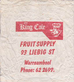
Functional object - Packaging: King Cole bag, Circa 1970
King Cole’s fruit shop operated in Liebig Street from around the 1940’s. It was operated by Alan Cole and his family for many years. Many of the advertisements of the mid20th century are advertising case lots of locally sourced product such as Portland and Harcourt. The business name King Cole continues to have a link with Warrnambool as a wholesale business which operates from the industrial Estate in Cooper St West Warrnambool.This item provides an historical and social link with the people of Warrnambool and district.White paper bag with red printing.King Cole Fruit supply 93 Liebig St Warrnambool, Phone 622699.warrnambool, king cole, alan cole, fruiterer, liebig st -
 Eltham District Historical Society Inc
Negative - Photograph, J.H. Clark, Main Road, Eltham, south from Brougham Street to Dalton Street, c.1911
Main Road, Eltham, south from Brougham Street to Dalton Street, c.1911 View looking down Policeman’s Hill on Maria Street (Main Road) from near Brougham Street towards Dalton Street, site of the Avenue of Honour established in 1916-1917 in memory of the soldiers who served in the First World War, 1914-1918. At the bottom of the hill on the right is White Cloud Cottage, home of the Jarrold family, three women standing out front observing the photographer. The road passes over a culvert which runs to the west in front of the cottage. The cottage was originally located closer to the Diamond Creek but was subject to flooding. It was dragged by horse to the present site shown, which was chosen for the higher ground that had been created as a result of land fill being deposited here from the quarry further around the bend on Main Road (site of present-day Eltham Primary School carpark) where the stone had been quarried for building the State School in Dalton Street. Immediately at the end of the straight section of the main road can be seen the gas streetlamp in front of the Jarrold home and the pond at the bottom of Dalton Street. The cottage had previously been rented for use as a Police Station / residence prior to the building of the permanent police house and station at the corner of Maria and Brougham streets in 1859. At the time of collection of photos for the centenary of the Shire of Eltham (1971) the cottage was owned by the Skipper family and remains in the family to present day (2021). On the left is the Grant house on the corner of Main Road and Dalton Street now the present-day site of Eltham Clinic. Cross Ref: 0749 for another view of the Jarrold family home Photographer: J.H. Clark John Henry Clark was the youngest of three boys born to William Henry Clark (1823-1877) and Maria White (1843-1914). He and his brothers, William Charles Clark (1872-1945), Clement Kent Clark (1874-1912) operated a photography business (Clark Bros.) from 25 Thomas Street, Windsor near Prahran during the period c.1894 to 1914. Following death of Clement in September 1912 and their mother in 1914, the Clark Bros business appears to have dissolved, the premises demolished, and a new house was under construction in 1915. John set up business independently in 1914 operating out of 29 Moor Street, Fitzroy where he is registered in the 1914 and 1915 Electoral Rolls. By 1916 John had relocated to Eltham where he continued his practice as a photographer and took many of the early images around the district of Little Eltham. Around 1930 John changed professions and opened a small cobbler's shop in 1931 near the pond opposite Dalton Street adjacent to the Jarrold family cottage. He never married and continued his profession as a bootmaker from this little shop, maintaining a close relationship with Mrs Jarrold for the rest of their lives. His bootmaker shop remains today beside the Whitecloud cottage and is one of only three remaining shops in the area from the early 20th century. There are a couple of images of Eltham taken by Clark Bros. in the Eltham District Historical Society collection, one such example being Hunniford’s Post Office with Miss Anne Hunniford out front (EDHS_00140 - marked on the back of the print, Clark Bros., 25 Thomas St. Windsor), which would date this image between c.1894 and 1914. Other early images of Eltham taken by John Henry Clark are marked on the face “J. H. Clark Photo” and it is assumed these are dated between 1914 and 1930. It is noted that the Grant of Probate for John H Clark of Eltham South dated 5 April !957 (513/387) records his occupation as "X Photographer".This photo forms part of a collection of photographs gathered by the Shire of Eltham for their centenary project book,"Pioneers and Painters: 100 years of the Shire of Eltham" by Alan Marshall (1971). The collection of over 500 images is held in partnership between Eltham District Historical Society and Yarra Plenty Regional Library (Eltham Library) and is now formally known as the 'The Shire of Eltham Pioneers Photograph Collection.' It is significant in being the first community sourced collection representing the places and people of the Shire's first one hundred years.Digital image 4 x 5 inch B&W Negshire of eltham pioneers photograph collection, eltham, main road, jarrold family, dalton street, j.h. clark photo, white cloud cottage, avenue of honour, eltham clinic, gas lamp, grant house, jarrold cottage, 1900 -
 Orbost & District Historical Society
book, Grove, Carl, BUKAN MUNGEE
C.H. Grove spent about 40 years in the area, information is mainly derived from his own recollections and "reliable sources". Charles Henry [Carl] Grove died on 17/4/1938 at Box Hill at the age of 88 and was buried in Orbost. Prior to coming to the Snowy River district, Carl worked as overseer on Buchan Station. In 1880, he selected land at Newmerella after first coming here in 1874 with early selector James A Robertson.He was one of the first selectors at Orbost - in 1880 he selected 320 acres at Newmerella, which he called „Ulinda‟ He married Annie Robertson in 1876. Carl was a farmer, hop and seed grower and nurseryman. He was an elected Councillor of the newly formed Tambo Shire in 1882, and then in 1892 to the Orbost Shire where he served for many years filling varioius public roles. In 1911, he shifted to Queensland, but later returned to Victoria and died at Box Hill. (Ref. Nov 2014 Newsletter) This is a useful reference tool.A carbon copy of a typeset manuscript / transcript book entitled "Bukan Mungee" containing historical and geographical information of the area "bounded by the Snowy River in the east, the Tambo river in the west...and with the following leaseholds, Ensay, Gillingall, and Gelantipy on the north, with Kilmore and Corringle stations on the south..."grove-carl bukan-mungee corringle newmerella snowy-river tambo-river -
 Ringwood and District Historical Society
Photograph, Coach and Horses Hotel, Ringwood circa 1940
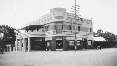
Black and white photograph of Coach and Horses Hotel in Maroondah Highway, west of New Street, now adjacent to Eastlink Freeway, on northern side. There are two duplicate photos. Certainly the photo was taken post-1940 as the previous Coach & Horses Hotel, on the south side, burnt down in 1940. The telephone pole indicates that era, with limited lines. The style of the building was Art Deco that generally existed in the 1920s-1930s but did continued in Australia in the 1940s. The building has the appearance of being newly-built. Was H4, in the old cataloguing system. -
 Ringwood and District Historical Society
Pamphlet, G.A. Green, Auction Sale Brochure - Garden Farms Estate, Ringwood, Victoria - 1919, 1919
Multi-fold brochure advertising public auction of one-acre, 2-acre, 5-acre and 8-acre allotments in Ringwood and Bayswater on Saturday 12th April, 1919. Brochure includes terms of sale, description of subdivision features and local facilities, and photographic images of the area.Subdivison includes Canterbury Road Heathmont, Armstrong Road Heathmont, Armstrong Road Bayswater, Bungalook Road Heathmont, Bungalook Road Bayswater, and Orchard Road Bayswater. Road shown as Bayswater Road to Bayswater became Mountain Highway Bayswater. Vendor: H.E.B.Armstrong, Auctioneers: Coghill & Haughton, 79 Swanston Street Melbourne, Telephone Central 2793, in conjunction with J.B. McAlpin, Ringwood, Opposite Station, Telephone Ringwood 7. (Map) Woodcock & McCormack, Civil Engineers Architects & Surveyors, 430 Little Collins Street, Melbourne, Phone 3241 Central. MOST OF THE MONEY COMES OUT OF THE LAND. And more money can be obtained from anb acre of fruit than from an acre of any other produce. But you do not have to grow fruit on Garden Farms Estate. You can go in for - Outer Suburban Home - Market Garden - Orchard - Pig Raising - Poultry Farm - Small Dairy Farm - Small Fruits - Floral Culture - Scent and Bee Farm - Or just for a Week-end Home. RINGWOOD - THE PLACE TO LIVE. The Beautiful Ringwood District has so many natural attractions, that half a Land Agent's work is done in just showing a prospective buyer round and about. Ringwood has a pull of its own that attracts folk, proved beyond doubt by its rapid development within the last decade (spite the war). First, it is high and healthy, picturesque and undulating, convenient of access, sufficiently close to the Metropolis for City and Business folk to live at Ringwood. Its development is solid, because most of its people are industrious husbandmen, real producers, who have turned idle hills into smiling gardens. These are the kind of real people to live amongst; ones who wear out their spades. The rapidly-developing town has excellent Stores, Trade and Repair Shops Churches, Banks, Telephone Exchange, Weekly General Market, Cool Stores, and good Private and State Schools, etc.; is Electrically lit, has Metropolitan Water Supply, and generally provides so that practically all shopping can be done locally. WHY RINGWOOD MUST GROW. Ringwood is a great centre and must be a greater. Two rapidly-developing railways junction here. The passengers from Ringwood Station cityward, in one year, number 250,000. Ringwood will be the terminus of the Outer Suburban Electric Eastern Railway. Its natural boundaries are the River Yarra on the North, Dandenong Creek on the South, the popular town of Croydon on the East, and the suburb of Mitcham on the West. This is a large territory that is steadily being converted from intense culture, and then it might be called (as regards its gardens) "The Devon Territory of Victoria." ARMSTRONG ROAD. This new road traverses Garden Farms Estate from its northern boundary on the main Canterbury Road, across Dandenong Creek, to its southern boundary on the main Bayswater Road, and will provide a long-desired additional link of communication between Bayswater and Ringwood. The 1-acre building sites on Bayswater Road are within 8 minutes' walk of the Bayswater Railway Station, and the Canterbury Road frontages are only 1-1/2 miles from Ringwood Station, and 1/2 mile from the Railway Station site of Canterbury Road; therefore, the whole Estate is easy of access and there should be a large demand for land so favourably placed. (Image) Cultivation Field - Potatoes on Lot 28 (Image) Picture of Bayswater Creek Flats. (Image) View from "Korumbeen" where Mr. Armstrong lived on Garden Farms Estate. Estate outlined in white ring. (Image) Site of New Bridge over Dandenong Creek. (Image) On one of the timbered lots adjoining railway. (Image) This Dandenong Creek traveres the Estate. (Image) Main Fern Tree Gully Line bisects the Estate. -
 Ringwood and District Historical Society
Photograph, Maroondah Highway West, Ringwood- 1878. Thomas Grant's original blacksmith's shop
Black and white photographTyped below photograph, "Mr. Thomas Grant's original blacksmith's shop in Maroondah Highway Ringwood - 1878. West of Ringwood St. on south side near drive-in shopping centre. (Opposite new ANZ bank). -
 Ringwood and District Historical Society
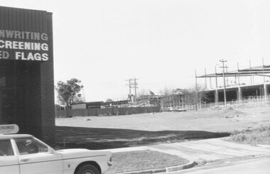
Photograph, Construction work at Target Square, NE corner of Maroondah Hwy and New Street, Ringwood - 1981, 1981
Two views of Target Square shopping complex building under construction.Written on back of photographs - V134a "29-6-81 View from Verstegen's no - New St across Brambles lot at the centre of Target building cnr of Charters-New St on right below Target." - V134b "30-6-81. Looking south from Brambles across Charter St. west end of Target. New St. just out of picture right". -
 Ringwood and District Historical Society
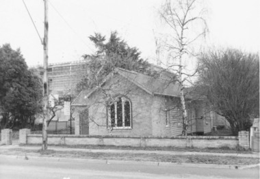
Photograph, The Gospel Church in Warrandyte Road, Ringwood in 1973, 1973
... . west side, 40 yards south of Miles Ave. 11.7.73"..., "Gospel Hall, W'dyte Rd. west side, 40 yards south of Miles Ave ...The Gospel Church in Warrandyte Road in 1973, with Eastland being extended in backgroundWritten on back of photograph, "Gospel Hall, W'dyte Rd. west side, 40 yards south of Miles Ave. 11.7.73" -
 Ringwood and District Historical Society
Photograph, Ringwood's first post office showing first postmistress, Miss M. Thompson. 1890
Typed below photograph, "Ringwood's first Post Office showing first Postmistress, Miss M. Thompson and her mother. 1890". (South side of Main Street (Maroondah Highway), approximately 300 meters west of Ringwood Railway Station). Writing on back of original photograph reads, "Grandma and Auntie Martha Thomson 1890". Stamps on back of photograph read, "Wall Bros. Photographers ... St. Kilda". Other stamp reads, "R.J.T. Futcher, Geelong, Victoria, Australia".