Showing 5154 items
matching no.422
-
 Glen Eira City Council History and Heritage Collection
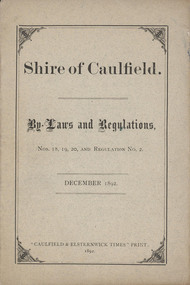
Booklet, "Shire of Caulfield. By-Laws and Regulations, Nos 18, 19, 20 and Regulation No.2. December 1892.", c. 1892
... , 20 and Regulation No.2. December 1892." ...Paper pamphlet generated by Council in December 1892 for the purpose of regulating the control of The Common Seal of the Municipality.Booklet titled "Shire of Caulfield. By-Laws and Regulations, Nos 18, 19, 20 and Regulation No.2. December 1892." Comprising 11 pages of double-sided, black printed text and a greyish colour paper cover with title and printers details printed on the cover. The interior pages are cream coloured and numbered at the top. Paper document commissioned by the Shire of Caulfield to list Shire By-Laws and Regulations. -
 Glen Eira City Council History and Heritage Collection
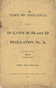
Booklet, "TOWN OF CAULFIELD. BY-LAWS 21, 22, and 23 AND REGULATION No. 3. 1902", c. 1902
... No. 3. 1902" ...Paper pamphlet generated by Council in December 1892 for the purpose of regulating the control of The Common Seal of the Municipality.Booklet comprising 27 paper pages with double-sided, black printed text and a dark cream coloured paper cover with Title, Price One Shilling and Printers details printed on the front cover. Paper document commissioned by Shire of Caulfield to list Shire By-Laws 21, 22, 23 and Regulation No.3 for the Town of Caulfield.Handwritten in grey lead pencil across top of front cover: "[illeg.] Hunt / Glen / Huntly Road / Glen Huntly". -
 Glen Eira City Council History and Heritage Collection
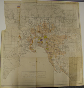
Map - Map, zoning, Metropolitan Town Planning Commission, "DISTRIBUTION AND USE OF EXISTING PROPERTY. MAP NO. 6.", 1929
... "DISTRIBUTION AND USE OF EXISTING PROPERTY. MAP NO. 6." ...The map titled: “Distribution and use of Existing property map No. 6” (Metropolitan Town Planning Commission Melbourne and Suburbs) is of historical significance. It is listed on page 168 of Chapter 4 the Zoning section of the "Plan of General Development Melbourne Report of the Metropolitan Town Planning Commission 1929" - Melbourne's first strategic plan. Map No. 6 is mentioned throughout Chapter 4 of the 1929 Report. It states on page 156 that this Map was created to graphically illustrate the data collected by the Planning Commission. The Map illustrates the general distribution of uses of existing property throughout the metropolitan area. The coloured sections show the areas which were developed or were in the process of development in 1929. The colours indicate the distribution of uses in the developed areas. The pink coloured areas, which include Caulfield, were almost completely residential.1929, metropolitan town planning commission, melbourne, suburbs -
 Glen Eira City Council History and Heritage Collection
Booklet, Vern Morgan Print, "City of Caulfield Provisions Governing Meetings Procedure; By-Law No. 151"
... ; By-Law No. 151" ...According to the last page of this booklet, the resolution for passing this by-law was agreed to by Council on the 4th of July 1972, and confirmed on the 1st of August 1972. "City of Caulfield Provisions Governing Meetings Procedure; By-Law No. 151" stapled orange booklet, with two holes punched on the left hand side, and has the words "CR. G.S. Patience” inscribed in black ink on the cover. The outer back cover has the words “Vern Morgan Print” at the bottom. Inscribed with the handwritten words "CR. G.S. Patience' in black ink on the cover. -
 Federation University Art Collection
Oil on masonite, Neville Bunning, 'Trip in Space No. 2' by Neville Bunning
... 'Trip in Space No. 2' by Neville Bunning ...This item is part of the Federation University Art Collection. The Art Collection features over 1000 works and was listed as a 'Ballarat Treasure' in 2007.Framed acrylic painting. Gift of Pauline Diggins, 2008art, artwork, available, horse, neville bunning, surrealism -
 Federation University Art Collection
Oil on board, 'The Rite of Spring No. 2' by Neville Bunning
... 'The Rite of Spring No. 2' by Neville Bunning ...This item is part of the Federation University Art Collection. The Art Collection features over 2000 works and was listed as a 'Ballarat Treasure' in 2007.Framed oil painting depicting four 'dancing' horses in a landscape. art, artwork, neville bunning, bunning, available, horses, animals -
 Federation University Art Collection
Painting, Where No Counsel Is, The People Fall: But in the Miltutude of Counsellors There is Safety. Proverbs 11:4
... Where No Counsel Is, The People Fall: But in the Miltutude ...Large paintinghorsham student collection -
 Lilydale RSL Sub Branch
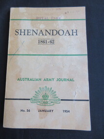
Book - Book - soft cover, Wilke & Co Ltd Melbourne, Shenandoah 1861-62, Australian Army Journal No. 56 - January 1954, 1954
... Shenandoah 1861-62, Australian Army Journal No. 56 ...Book -
 Lilydale RSL Sub Branch
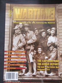
Magazine - paperback/magazine/series, Philip J Turner & Rex Curtis-Griffiths, Wartime No.4, 1998
... Wartime No.4 ...Official Magazine of the Australian War MemorialMagazineOfficial Magazine of the Australian War Memorialmontbrehain 1918, western desert, operation ulmarra-vietnam, botony bay, borneo bullesque -
 Lilydale RSL Sub Branch
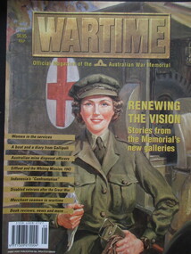
Magazine - paperback/magazine/series, Philip J Turner & Rex Curtis-Griffiths, Wartime No 5, 1999
... Wartime No 5 ...Official Magazine of the Australian War MemorialMagazineOfficial Magazine of the Australian War Memorialservice women, gallapoli diary, mine disposal, disabled veterans, merchant seamen, indonesia's confrontation -
 Lilydale RSL Sub Branch
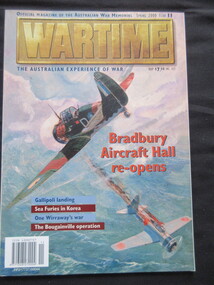
Magazine - paperback/magazine/series, Peter Londey, Wartime No. 11, 2000
... Wartime No. 11 ...Official Magazine of the Australian War MemorialMagazineOfficial Magazine of the Australian War Memorialbradbury aircraft hall, bouganville, gallipoli landing, wirraway, sea furies in korea -
 Lilydale RSL Sub Branch
Magazine - paperback/magazine/series, Peter Londey, Wartime No. 12, 2000
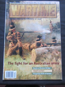
... Wartime No. 12 ...Official Magazine if the Australian War MemorialMagazineOfficial Magazine if the Australian War Memorialbattle of broken bridge, forgotten field of heroes, island warriors -
 Lilydale RSL Sub Branch
Magazine - paperback/magazine/series, Michael Thomas, Wartime No.13, 2001
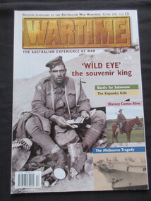
... Wartime No.13 ...Official Magazine of the Australian War MemorialMagazineOfficial Magazine of the Australian War Memorial"wild eye" the souvenir king, battle for salamaua, the kapooka kids -
 Lilydale RSL Sub Branch
Magazine - paperback/magazine/series, Michael Thomas, Wartime No. 14, 2001
... Wartime No. 14 ...Official Magazine of the Australian War MemorialMagazinenon-fictionOfficial Magazine of the Australian War Memorialchunuk bair, anzacs in iraq, kiwi's in anzac, malta, middleton vc, thermoplae, kangaroo feathers -
 Lilydale RSL Sub Branch
Magazine - paperback/magazine/series, Michael Thomas, Wartime No 16, 2001
... Wartime No 16 ...Official Magazine of the Australian War MemorialMagazinenon-fictionOfficial Magazine of the Australian War Memorial -
 Lilydale RSL Sub Branch
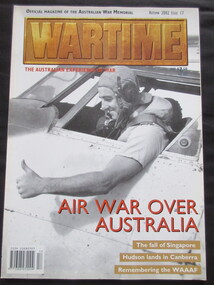
Magazine - paperback/magazine/series, Michael Thomas, Wartime No 17, 2002
... Wartime No 17 ...Official Magazine of the Australian War MemorialMagazinenon-fictionOfficial Magazine of the Australian War Memorialwaaf, sabres in sydney, air war over australia, hudson of canberra -
 Lilydale RSL Sub Branch
Magazine - paperback/magazine/series, Michael Thomas, Wartime No 18, 2002
... Wartime No 18 ...Official Magazine of the Australian MemorialMagazinenon-fictionOfficial Magazine of the Australian Memorialkokoda commanders, breaker morant, vietnam vc, shy vc, bullecourt, air war over malta -
 Round the Bend Conservation Co-operative
All members were involved in this physically demanding work of laying the power and telephone cables underground, which resulted in mitigating the fire risk and the aesthetic value of no power poles!
... resulted in mitigating the fire risk and the aesthetic value of no ... -
 Federation University Art Collection
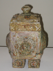
Ceramic - Artwork - Ceramics, 'Reliquary No. 20' by John O'Loughlin, 2007
... 'Reliquary No. 20' by John O'Loughlin ...John O'LOUGHLIN Born Snowtown, South Australia In 1980 John O'Loughlin's life changed when he started wheel throwing ceramic vessels. During this time he discarded the superfluous and unnecessary clutter collected on the journey of life, yet retaining the essence of what mattered to him. John O’Loughlin's later artworks, such as 'Reliquary No. 20' engages with the way in which organised religion, specifically the Catholic Church, deals with the translation of the spiritual into the material. Informed by his extensive travels and studies, O’Loughlin’s ceramics reference the reliquaries and church artefacts that connect the life of this world with that of faith in another world. Completing undergeduate and post graduate works at Federation University John O'Loughlin's honours thesis was entitled "Ways and Means of Meaning, The Use of Symbol and Surface as Expressive Media in Ceramic Sculpture". The University provided a serious ceramic studio equipped with all the research tools for advanced ceramic exploration. Access to raw materials and a variety of kilns combined with excellent lecturers, mentors and technicians inspired, motivated and challenged him to push his accumulating knowledge to higher levels. O'Loughlin's working method in the studio is one of quiet, determined interaction with clay, idea and content. Experimentation with a variety of temperatures, firing methods and atmospheric conditions has produced a broad tonal and textural palette. He has worked with various clay bodies overlaid with coloured oxides, slips and engobes as the foundation for many of his works. O'Loughlin ufilised raised surfaces from old cemetery tombstones using the impressed forms and textures in his constructions. This research led him to the use of dry engobes to create a sense of antiquity, with crusty and distressed surfaces that resemble objects neglected in the oceans. These objects seem covered with the accretions and accumulations of history when re-discovered and brought to the surface as miraculous objects of mystery and magic. (https://www.thefreelibrary.com/John+O%27Loughlin%3A+a+man+re-invented.-a0216897107, accessed 12 September 2020) This item is part of the Federation University Art Collection. The Art Collection features over 2000 works and was listed as a 'Ballarat Treasure' in 2007.Lidded ceramic form.art, artwork, john o'loughlan, ceramics, available, available ceramics -
 Federation University Art Collection
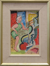
Oil on canvasboard, 'The House Wife No.2' by Neville Bunning
... 'The House Wife No.2' by Neville Bunning ...This item is part of the Federation University Art Collection. The Art Collection features over 2000 works and was listed as a 'Ballarat Treasure' in 2007.Framed painting of a woman in green dress holding a vacuum cleaner.art, artwork, neville bunning, domestic goddess, available -
 Federation University Art Collection
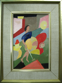
Artwork - Painting, Neville Bunning, 'The House Wife No. 1' by Neville Bunning
... 'The House Wife No. 1' by Neville Bunning ...This item is part of the Federation University Art Collection. The Art Collection features over 1000 works and was listed as a 'Ballarat Treasure' in 2007.Small framed artwork.art, artwork, neville bunning, housewife, abstract -
 Federation University Art Collection
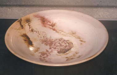
Ceramic - Platter, 'Platter No 131' by Milton Moon OA, 1979
... 'Platter No 131' by Milton Moon OA ...Milton Moon (1926-2019) Born Melbourne, Victoria Milton Moon attended the Central Technical College, Brisbane where he studied painting and drawing. In 1950 he undertook study in Ceramics with Harry Menmott and Mervyn Feeney at the Sandison Pottery, Brisbane. He lectured in Ceramics at Central Technical College, Brisbane, and he was awarded a Churchill a Fellowship in 1966. In 1974 he travelled and worked in Japan for a year, and established a workshop at Summertown in the Adelaide Hills. In 1984 Milton Moon was awarded the Order of Australia Medal for his services to ceramics. Milton Moon died in 2019. At the time of his death his website included the following:- "In this, my 'ninety second year,' over sixty of which I have been a potter, I remain concerned, if a little obsessed, with the challenge of making pots, which although belonging to a ceramic tradition of some eight thousand years or more, are undeniably and uniquely Australian. With all my changes of expression this has remained constant. The initial creative inspirations were drawn from the beauty of the coastal areas of Eastern Australia and from the mountain areas of the Great Dividing Range which stretch from North Queensland to the extreme South of Victoria. But the most lasting inspiration has come from the inland of Australia, more particularly from the Gammon and Flinders Ranges and from the Olary Uplands of South Australia, and more recently the Pilbara and Kimberley areas of Western Australia, where rock engravings place them as being amongst the oldest marks left by human-kind anywhere in the world. All parts of Australia are full of an ancient history stretching back through time and which today, despite white settlement, somehow still survives in legend and ritual. If it is the case that these legends do now only exist, in some muted half-life there is still the sense that they remain as a very powerful 'spirit-presence.' It is impossible to ignore the feeling that this country remains inhabited by the past. For me it is also impossible not to creatively respond to the echoes of the past, even if only through the somewhat vague process of inspiration and distillation. To understand this spirit, even a little, is a privilege but to try an express it is a compelling endeavour. This item is part of the Federation University Art Collection. The Art Collection features over 2000 works and was listed as a 'Ballarat Treasure' in 2007.Large ceramic platter, framed for display on wall.art, artwork, milton moon, ceramics -
 Federation University Art Collection
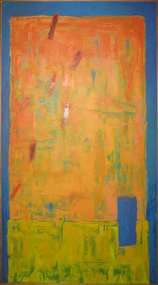
Painting, Janelle Vaughan, 'No.8. Blue, Yellow & Orange' by Janelle Vaughan, 2001
... 'No.8. Blue, Yellow & Orange' by Janelle Vaughan ...This item is part of the Federation University Art Collection. The Art Collection features over 1000 works and was listed as a 'Ballarat Treasure' in 2007. This work was purchased from the University of Ballarat 'Goodbye Helen' end of year exhibition.Oil on canvas painting featuring blue, orange and yellow. art, artwork, churchill, gippsland campus, school of business collection, janelle vaughan -
 Surrey Hills Historical Society Collection
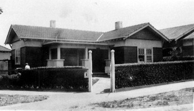
Photograph, No 1 Blackburn Street
... No 1 Blackburn Street ...The house was built c1920. The first occupant was Mr George Leslie Miles, a grocer, also resident at 5 Empress Road. He was followed by Mr Charles Frederick Barrow, an electrical mechanic, who later moved to 316 Canterbury Road.A black and white photograph of a Californian Bungalow style house in a corner location. A fence with a neat hedge border two sides of the property. Gate posts are at the corner of the property.1920, surrey hills, blackburn street, bedford avenue, mr charles frederick barrow, mr george leslie miles -
 Surrey Hills Historical Society Collection
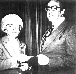
Photograph, Mrs Frances Le Couteur & Mr Patrick Dunne, Headmaster at Chatham School No.4314 at the Golden Jubilee 1927-1977, 1977
... Chatham School No.4314 at the Golden Jubilee 1927-1977 ...Mr & Mrs Le Couteur were both employed in the Education Department. Frank was an Inspector of Schools and Frances taught at Canterbury Primary for 20 years and at Chatham Primary in 1927, the year the school opened. She loved music, attended the Salvation Army and taught music and at the Sunday School at their chapel in Guildford Road. She moved to Inala Village. Patrick Thomas Dunne was registered with the Education Department in 1949. Registration no. 40787.A black and white photograph of a Mrs Le Couteur and Mr Patrick Dunne, Headmaster 1977 passing a note/gift between each other at the Chatham School's No. 4314 Golden Jubliee 1927-1977.chatham school no.4314, festivals and celebrations, salvation army, headmaster, teacher, 1927, 1977, golden jubliee, guildford road, surrey hills, patrick dunne, (mrs) frances charlotte le couteur -
 Kew Historical Society Inc
Plan - Subdivision Plan, Plan of Subdivision of Part of Crown Portion 84 / Parish of Boroondara / County of Bourke / Lodged Plan No. 2217, Twentieth Century
... Boroondara / County of Bourke / Lodged Plan No. 2217 ...Pru Sanderson, in her groundbreaking ‘City of Kew Urban Conservation Study : Volume 2 - Development History’ (1988), summarised the periods of urban development and subdivisions of land in Kew. The periods that she identified included 1845-1880, 1880-1893, 1893-1921, 1921-1933, 1933-1943, and Post-War Development. These periods were selected as they represented periods of rapid growth or decline in urban development. An obvious starting point for Sanderson’s groupings involved population growth and the associated economic cycles. These cycles also highlighted urban expansion onto land that was predominantly rural, although in other cases it represented the decline and breakup of large estates. A number of the plans in the Kew Historical Society’s collection can also be found in other collections, such as those of the State Library of Victoria and the Boroondara Library Service. A number are however unique to the collection.The Kew Historical Society collection includes almost 100 subdivision plans pertaining to suburbs of the City of Melbourne. Most of these are of Kew, Kew East or Studley Park, although a smaller number are plans of Camberwell, Deepdene, Balwyn and Hawthorn. It is believed that the majority of the plans were gifted to the Society by persons connected with the real estate firm - J. R. Mathers and McMillan, 136 Cotham Road, Kew. The Plans in the collection are rarely in pristine form, being working plans on which the agent would write notes and record lots sold and the prices of these. The subdivision plans are historically significant examples of the growth of urban Melbourne from the beginning of the 20th Century up until the 1980s. A number of the plans are double-sided and often include a photograph on the reverse. A number of the latter are by noted photographers such as J.E. Barnes.Undated Plan of Subdivision of Crown Portion 84 in what is now Kew. The area shown is bordered by Burke Road, Harp Road, Arglye Road and Normanby Road.subdivision plans -- kew (vic), harp road, burke road, normanby road, lady loch's drive, gladstone street, second avenue, first avenue -
 Kew Historical Society Inc
Plan, Melbourne & Metropolitan Board of Works : Borough of Kew : Detail Plan No.1291, 1905
... : Detail Plan No.1291 ...The Melbourne and Metropolitan Board of Works (MMBW) plans were produced from the 1890s to the 1950s. They were crucial to the design and development of Melbourne's sewerage and drainage system. The plans, at a scale of 40 feet to 1 inch (1:480), provide a detailed historical record of Melbourne streetscapes and environmental features. Each plan covers one or two street blocks (roughly six streets), showing details of buildings, including garden layouts and ownership boundaries, and features such as laneways, drains, bridges, parks, municipal boundaries and other prominent landmarks as they existed at the time each plan was produced. (Source: State Library of Victoria). This plan forms part of a large group of MMBW plans and maps that was donated to the Society by the Mr Poulter, City Engineer of the City of Kew in 1989. Within this collection, thirty-five hand-coloured plans, backed with linen, are of statewide significance as they include annotations that provide details of construction materials used in buildings in the first decade of the 20th century as well as additional information about land ownership and usage. The copies in the Public Record Office Victoria and the State Library of Victoria are monochrome versions which do not denote building materials so that the maps in this collection are invaluable and unique tools for researchers and heritage consultants. A number of the plans are not held in the collection of the State Library of Victoria so they have the additional attribute of rarity.Original survey plan, issued by the MMBW to a contractor with responsibility for constructing sewers in the area identified on the plan within the Borough of Kew. The plan was at some stage hand-coloured, possibly by the contractor, but more likely by officers working in the Engineering Department of the Borough and later Town, then City of Kew. The hand-coloured sections of buildings on the plan were used to denote masonry or brick constructions (pink), weatherboard constructions (yellow), and public buildings (grey). A detail plan of part of Studley Park bordered by the major streets of Hodgson Street, Stevenson Street and Studley Park Road. Included on the plan are a number of significant Studley Park mansions in existence at the beginning of the 20th century. The unnamed street shown in the middle of the plan is McEvoy Street. The most important house still extant is Campion House, formerly named Dalsraith [Dalswraith] and Glendalough, owned since the 1940s by the Society of Jesus. Campion House can be seen on the corner of Hodgson and Studley Park Road. Its stables at the rear of the block have now been incorporated into a contemporary residence. An interesting feature of the plan is the 1910 annotation by Ed Seitz, professional designing engineer. Is Seitz the contractor who modified the MMBW original?melbourne and metropolitan board of works, detail plans, mmbw 1291, cartography -
 Kew Historical Society Inc
Plan, Melbourne and Metropolitan Board of Works, Melbourne & Metropolitan Board of Works : Borough of Kew : Detail Plan No.1294 & 1295, 1904
... : Detail Plan No.1294 & 1295 ...The Melbourne and Metropolitan Board of Works (MMBW) plans were produced from the 1890s to the 1950s. They were crucial to the design and development of Melbourne's sewerage and drainage system. The plans, at a scale of 40 feet to 1 inch (1:480), provide a detailed historical record of Melbourne streetscapes and environmental features. Each plan covers one or two street blocks (roughly six streets), showing details of buildings, including garden layouts and ownership boundaries, and features such as laneways, drains, bridges, parks, municipal boundaries and other prominent landmarks as they existed at the time each plan was produced. (Source: State Library of Victoria). This plan forms part of a large group of MMBW plans and maps that was donated to the Society by the Mr Poulter, City Engineer of the City of Kew in 1989. Within this collection, thirty-five hand-coloured plans, backed with linen, are of statewide significance as they include annotations that provide details of construction materials used in buildings in the first decade of the 20th century as well as additional information about land ownership and usage. The copies in the Public Record Office Victoria and the State Library of Victoria are monochrome versions which do not denote building materials so that the maps in this collection are invaluable and unique tools for researchers and heritage consultants. A number of the plans are not held in the collection of the State Library of Victoria so they have the additional attribute of rarity.Original survey plan, issued by the MMBW to a contractor with responsibility for constructing sewers in the area identified on the plan within the Borough of Kew. The plan was at some stage hand-coloured, possibly by the contractor, but more likely by officers working in the Engineering Department of the Borough and later Town, then City of Kew. The hand-coloured sections of buildings on the plan were used to denote masonry or brick constructions (pink), weatherboard constructions (yellow), and public buildings (grey).The streets and built structures in MMBW Detail Plan 1294 & 1295 were surveyed in 1903 and released to contractors in 1904. This plan is one of two in the collection where the lithographers amalgamated two separate plans. Both plans include sections of Studley Park. Dominating the south and west corners of Kew Junction are the Clifton and Kew Hotels. The Kew Hotel, owned by Patrick O’Shaughnessy was one of the oldest in Kew. MMBW plans were amended over time to take account of new subdivisions such as that which created Merrion Place. Of the four mansions shown in Studley Park Road, three remain – ‘Field Place’, the home of Frances Henty, ‘Leaghur’ and ‘Darley’. ‘Byram’ (later ‘Goathland’, then ‘Tara Hall’) was an architectural marvel. Designed in 1888 by E.G. Kilburn for the paper magnate George Ramsden, it was demolished in 1960. While an earlier sale of the southern section of Byram had created Tara Avenue in 1927, the demolition of the house in 1960 enabled the extension of Tara Avenue northward.melbourne and metropolitan board of works, detail plans, mmbw 1294, mmbw 1295, cartography -
 Kew Historical Society Inc
Plan, Melbourne & Metropolitan Board of Works : Borough of Kew : Detail Plan No.1296, 1904
... : Detail Plan No.1296 ...The Melbourne and Metropolitan Board of Works (MMBW) plans were produced from the 1890s to the 1950s. They were crucial to the design and development of Melbourne's sewerage and drainage system. The plans, at a scale of 40 feet to 1 inch (1:480), provide a detailed historical record of Melbourne streetscapes and environmental features. Each plan covers one or two street blocks (roughly six streets), showing details of buildings, including garden layouts and ownership boundaries, and features such as laneways, drains, bridges, parks, municipal boundaries and other prominent landmarks as they existed at the time each plan was produced. (Source: State Library of Victoria)This plan forms part of a large group of MMBW plans and maps that was donated to the Society by the Mr Poulter, City Engineer of the City of Kew in 1989. Within this collection, thirty-five hand-coloured plans, backed with linen, are of statewide significance as they include annotations that provide details of construction materials used in buildings in the first decade of the 20th century as well as additional information about land ownership and usage. The copies in the Public Record Office Victoria and the State Library of Victoria are monochrome versions which do not denote building materials so that the maps in this collection are invaluable and unique tools for researchers and heritage consultants. A number of the plans are not held in the collection of the State Library of Victoria so they have the additional attribute of rarity.Original survey plan, issued by the MMBW to a contractor with responsibility for constructing sewers in the area identified on the plan within the Borough of Kew. The plan was at some stage hand-coloured, possibly by the contractor, but more likely by officers working in the Engineering Department of the Borough and later Town, then City of Kew. The hand-coloured sections of buildings on the plan were used to denote masonry or brick constructions (pink), weatherboard constructions (yellow), and public buildings (grey). This area was once known as O’Shaughnessy’s Paddock. O’Shaughnessy was the licensee of the Kew Hotel. The ‘Paddock’ or farm was for many years the closest farm to Melbourne. By 1903, when this plan was surveyed and lithographed, little of the farm remained. The area is dominated by a ‘clay hole’, on the site of the current Foley Reserve. It was used by Smart’s Brickyard from the 1880s until 1911, when the Council purchased it for a rubbish dump. It is notable as the site is one of the few industrial operations to have existed in Kew. By 1903, urban development was characterised by larger houses fronting Barkers Road and brick and weatherboard villas in Foley Street. Nearer the pit, weatherboard houses predominated. Foley Street bisected the triangular block and continued right to Denmark Street. At this stage, a house impeded the through road, only allowing access via a right of way to High Street.melbourne and metropolitan board of works, detail plans, mmbw 1296, cartography -
 Kew Historical Society Inc
Plan, Melbourne & Metropolitan Board of Works : Borough of Kew : Detail Plan No.1297, 1904
... : Detail Plan No.1297 ...The Melbourne and Metropolitan Board of Works (MMBW) plans were produced from the 1890s to the 1950s. They were crucial to the design and development of Melbourne's sewerage and drainage system. The plans, at a scale of 40 feet to 1 inch (1:480), provide a detailed historical record of Melbourne streetscapes and environmental features. Each plan covers one or two street blocks (roughly six streets), showing details of buildings, including garden layouts and ownership boundaries, and features such as laneways, drains, bridges, parks, municipal boundaries and other prominent landmarks as they existed at the time each plan was produced. (Source: State Library of Victoria)This plan forms part of a large group of MMBW plans and maps that was donated to the Society by the Mr Poulter, City Engineer of the City of Kew in 1989. Within this collection, thirty-five hand-coloured plans, backed with linen, are of statewide significance as they include annotations that provide details of construction materials used in buildings in the first decade of the 20th century as well as additional information about land ownership and usage. The copies in the Public Record Office Victoria and the State Library of Victoria are monochrome versions which do not denote building materials so that the maps in this collection are invaluable and unique tools for researchers and heritage consultants. A number of the plans are not held in the collection of the State Library of Victoria so they have the additional attribute of rarity.Original survey plan, issued by the MMBW to a sewage contractor with responsibility for constructing sewers in the area identified on the plan within the Borough of Kew. The plan was at some stage hand-coloured, possibly by the contractor, but more likely by officers working in the Engineering Department of the Borough and later Town, then City of Kew. The hand-coloured sections of buildings on the plan were used to denote masonry or brick constructions (pink), weatherboard constructions (yellow), and public buildings (grey). This plan of Kew encompasses the area bounded by Barkers Road, High Street and Stevenson Street. Because of the angle created by High Street, a number of houses on the northern side of High Street are shown. The area is dominated by one of the great original landholdings in Kew, described here as the ‘Findon Paddock’. ‘Findon’, the house from which the name of the paddock was taken fronts Stevenson Street and was clearly a rambling structure. The best-known occupant of Findon was Henry ‘Money Miller’ who bought the house in 1871. Miller was a member of Victoria’s first parliament and assisted in the framing of its constitution. Findon was to be subdivided as early as 1912, when the Findon Subdivision was advertised to be sold by auction. In the plan of the subdivision, the original house is not shown, so, presumably it had previously been demolished. Fincham & Son moved the organ, built by Henry Willis, which was installed in the house, first to ‘Whernside’ in Toorak, and later to the Box Hill Methodist Church.melbourne and metropolitan board of works, detail plans, mmbw 1297, cartography, kew (vic.) — municipal collection