Showing 5190 items
matching station station
-
 Eltham District Historical Society Inc
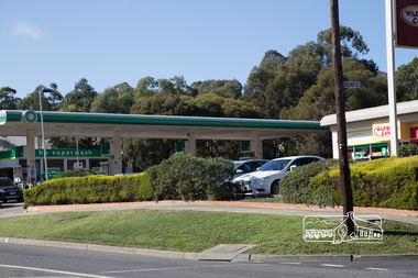
Photograph, Peter Pidgeon, BP Service Station, cnr Main Road and Beard Street, Eltham, 3 May 2017, 3 May 2017
... BP Service Station, cnr Main Road and Beard Street, Eltham...bp service station... melbourne eltham main road beard street bp service station Born ...Born Digitaleltham, main road, beard street, bp service station -
 Eltham District Historical Society Inc
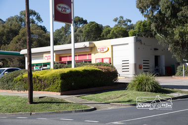
Photograph, Peter Pidgeon, BP Service Station, cnr Main Road and Beard Street, Eltham, 3 May 2017, 3 May 2017
... BP Service Station, cnr Main Road and Beard Street, Eltham...bp service station... melbourne eltham main road beard street bp service station Born ...Born Digitaleltham, main road, beard street, bp service station -
 Kiewa Valley Historical Society
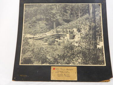
Photo of No. 3 Power Station at Kiewa Hydro Electric Scheme, No. 3 Power Station at Kiewa Hydro Electric Scheme
... Photo of No. 3 Power Station at Kiewa Hydro Electric Scheme...No. 3 Power Station at Kiewa Hydro Electric Scheme...no.3 power station. kiewa hydro electric scheme. s.e.c.v..., power stations and the infrastructure for the work... station and workmen's huts and storage huts, site manager's office... Hydro Scheme. The work included building dams, power stations ...The State Electricity Commission of Victoria were the employers of the Kiewa Hydro Scheme. The work included building dams, power stations and the infrastructure for the work and their employees. Mt Beauty and Bogong village were the places where this scheme was built and where this photo shows part of its construction being Power Station 3. Originally there were 3 Hydro stations built from the 1930's onwards. The scheme finished being built in 1960 and is the biggest Hydro electricity scheme in Victoria. This photo has good Historic significance: The construction of No. 3 Power Station which was part of the Kiewa Hydro Electric Scheme built by the State Electricity Commission of Victoria. Therefore is picture is very historically significant as it shows the power station at the time of its construction which is an important part of Victoria' development and history. Since Mt Beauty was established due to the Hydro scheme being built this photo has great interpretation capacity. This is a black and white photograph showing the power station and workmen's huts and storage huts, site manager's office and surrounding bush. The photo is mounted on black painted 3 ply board. no.3 power station. kiewa hydro electric scheme. s.e.c.v..electricity. -
 Kiewa Valley Historical Society
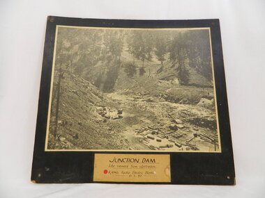
Photo of Junction Dam - Kiewa Hydro Electric Scheme, Junction Dam, Kiewa Hydro Electric Scheme, Photo taken 10th Feb. 1940
... Hydro Scheme. The work included building dams, power stations.... The work included building dams, power stations ...The Junction Dam was built by the State Electricity Commission of Victoria as part of the Kiewa Hydro Electric Scheme. This photo show its construction in February 1940. The State Electricity Commission of Victoria were the employers of the Kiewa Hydro Scheme. The work included building dams, power stations and the infrastructure for the work and their employees. Mt Beauty and Bogong village were the places where this scheme was built and where this photo shows part of its construction being Power Station 3. Originally there were 3 Hydro stations built from the 1930's onwards. The scheme finished being built in 1960 and is the biggest Hydro electricity scheme in Victoria.This photo has Historic significance due to Junction Dam built as part of the Kiewa Hydro Electric Scheme by the State Electricity Commission of Victoria. This photo shows its construction in February 1940. This is a black and white photo of Junction Dam viewed from upstream. Junction Dam was part of the Kiewa Hydro Electric Scheme. The picture shows piles of wood and pipes, crane, trucks and a shed on the cleared ground. The photo is mounted on 3 ply wood, painted black.kiewa hydro electric scheme. junction dam. s.e.c.v.. -
 Kiewa Valley Historical Society
Photos - Box of 6, A3 size, Rubicon Scheme Construction
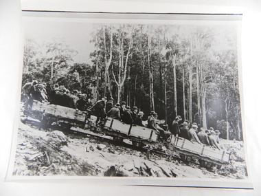
... station. rubicon haulage. state electricity commission of victoria.... Falls Power Station Woodstave Pipeline Replaced since with steel...1.A.N. 427To R.J. Wegener Station Engineer. Rubicon Area 2.... rubicon power station. rubicon haulage. state electricity ...S.E.C.V. scheme prior to Kiewa Hydro Electric Scheme (and features in the SECV magazines.6 photos stored in yellow Kodak box. 1. Original Rubicon Falls Power Station Woodstave Pipeline Replaced since with steel pipe. B & W photo Est. 1940. 2. Original Wall of Eildon Weir was Submerged when new wall & new Power Station was built in Mid - Late 1950s. 3. B & W photograph of Rubion Falls Power Station under construction late 1920's - Early 1930's 4. Royston Woodstave Pipeline under construction parts of the pipeline are still in service Photo set. 1932 Timber used is Canadian Spruce 5.Rubicon Power Station in Foreground Construction buildings in background Rubicon Scene - late 1920's - early 1930's 6. Haulage Rubicon estimate mid-late 1920's. The means of transport to civilisation for the working parties constructing the Rubicon Scheme1.A.N. 427To R.J. Wegener Station Engineer. Rubicon Area 2. A.N. 429 3. A.N. 435 4. A.N. 436 5. A.N. 425 6. A.N. 437 rubicon scheme. woodstave pipe. rubicon pipeline. r.j. wegener. eildon weir. royston. canadian spruce. rubicon power station. rubicon haulage. state electricity commission of victoria. -
 Kiewa Valley Historical Society
Ron White's Collection - 1920 - 2019
... Assistant Area Engineer, Rubicon at new Eildon Power Station... at new Eildon Power Station and Area Engineer, Kiewa ...Ron White was born in 1920. He received a Diploma of Mechanical Engineering at Footscray Technical School in 1946. He started work as a laboratory assistant and after several promotions was appointed Senior Operator in 1948. In 1949, he was Engineer, Grade 1 (Hydro Areas). After further promotions he became Assistant Area Engineer, Rubicon at new Eildon Power Station and Area Engineer, Kiewa in commissioning Mt Beauty Terminal Station and West Kiewa Power Station.. By 1956, he was the Area Operations Engineer at Kiewa and four years later the Kiewa Electrical Superintendent (Operations and Maintenance) . In 1961, he was officially recognised as deputy for the General Superintendent, Kiewa. In 1966 he was appointed General Superintendent Kiewa and Kiewa became 'a branch of the Transmission Department'. In 1974, the Rubicon / Eildon Area was also under Ron's control. His title was "Principal Hydro Engineer, Hydro Division, Transmission Operations Department. He held this position until his retirement in 1985.Ron White was an important identity in his role as Principal Hydro Engineer from 1966 to 1985 after the completion of the Kiewa Hydro Electric Scheme. His long period of service involved him in the construction, operation and maintenance of the SECV's Hydro Electric Schemes and administration of related catchment areas. He had a close association with the local communities and care for the welfare of employees. He lived in Mt Beauty and was well respected in the community and beyond. He passed away on 30 September 2019, aged 99 years.A) History of Ron White's Working Life: including papers relating to "Promotion & Staff Appointment" B) Ron White's Retirement - 11th Jan. 1985: papers, cards, letters, photos, disc/plaque C) Ron White's Certificates: Diploma of Mechanical Engineering; First Aid; D) Ron White's Correspondence - miscellaneous E) Ron White's History of the 'Kiewa Scheme' from 1936- 1966. Written 1986 F) Ron White's Photo album Includes photos of him and the 2003 bushfires G) Miscellaneous Photos (not labelled) from Ron's photo album. Possibly relatives including nieces and nephews. H) Pewter Mug presented to Ron - Water Board I) Wall hanging presented to Ron - Scouts J) Ron White's Slide Ruler & Mathematical Instruments K) Collection of 7 books owned by Ron L) Starting Pistol Caps box M) Ice-cream serverF) One photo of Ron with 'Ken Connors'. One photo with 'l to r: Norm Middleton, Graham Napier, Ron White, Les Peart.' G) 2003 fires has a note re time, date and whereabouts of fires H) "Presented To / Ron White / In Appreciation For Service / To The / Kiewa Valley / Water Authority / And / Its predecessor Bodies / December 1994 I) Wall hanging: On emblem - "Lord Baden-Powell Society / The Scout Association of Australia". On Name Plate below - Ronald K. White 1989" J) mathematical Instruments have 'R. W' embossed in red on the corner of the cover M) 100 Straitline, Starting Pistol Caps N) National Ice-cream Server with stainless steel spring Size 20 ron white, hydro engineer, kiewa hydro electric scheme -
 Kiewa Valley Historical Society
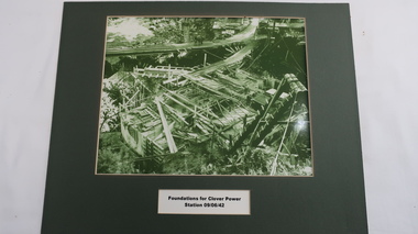
Photo - Foundations of Clover Power Station
... Photo - Foundations of Clover Power Station...clover power station...Clover Power Station was being constructed on 9th June 1942... Power Station was being constructed on 9th June 1942 ...Clover Power Station was being constructed on 9th June 1942 by the State Electricity Commission of Victoria as part of the Kiewa Hydro Electric Scheme.Clover Power Station is situated near the Bogong Township and was the first power station in the KHES to be constructed.Green filtered photo with title ( black on white) underneath framed with green cardboard.clover power station, kiewa hydro electric scheme -
 Kiewa Valley Historical Society
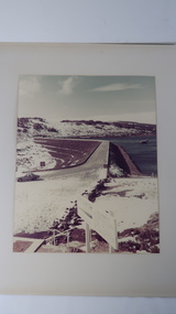
Photo - Rocky Valley Dam
... , tunnels, pipelines, transmission lines and three power stations..., transmission lines and three power stations.. Rocky Valley dam ...The State Electricity Commission of Victoria constructed the Kiewa Hydro Electric Scheme on the Bogong High Plains. The scheme consisted of storage dams and pondages, aqueducts, tunnels, pipelines, transmission lines and three power stations.. Rocky Valley dam was the biggest storage and the last to be completed.Rocky Valley dam was the largest storage within the Kiewa Hydro Electric Scheme. Begun in 1954 and completed in 1960. It was linked to McKay Creek Power StationColoured photo attached to cream cardboard. The background shows hills and the foreground a sign "Rocky Valley Dam ..." The middle shows the dam with water and its bank. There is snow on the ground.rocky valley dam, kiewa hydro electric scheme, secv -
 Kiewa Valley Historical Society
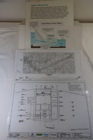
Plans - 2 Southern Hydro - Bogong Power Development and 1 Poster - Hydro-Electricity
... Station / Cross Section Sheet 4 of 6 Dated: June 2006 (Also see.... Tunnel and Civil Works / Power Station / Cross Section Sheet 4 ...Southern Hydro owned the Kiewa Hydro Electric Scheme in 2006. Southern Hydro owned the Kiewa Hydro Electric Scheme in 2006.Laminated A3 sheets The two Southern Hydro Bogong Power Development are black and white. 1. Tunnel and Civil Works / Power Station / Cross Section Sheet 4 of 6 Dated: June 2006 (Also see KVHS 1438) 2. Bogong Power / Development Waterway. Waterway Plan & Longsection / with Boreholes & Seismic Lines (Also see KVHS 1438) 3. Title: Hydro-Electricity in blue at the top and half-way down a blue and brown diagram titled 'Hydro-Electric Power Station'. At the bottom the title 'What is a watt?' southern hydro 2006, bogong power development -
 Kiewa Valley Historical Society
Safety Helmet - SECV
... McKay Creek Power Station.... While working at McKay Creek Power Station, Alec Menzies was hit ...Safety helmets were used by workers on the Kiewa Hydro Electric Scheme.While working at McKay Creek Power Station, Alec Menzies was hit on the head with a rock and fell about 10 metres. Luckily he survived, and after a stint in hospital he was admitted to what was known as the Turtle Club. Ref. Mal Menzies, his son.Cream coloured safety helmet with 3 ridges at the top from back to front. It is light in weight. Inside has an attached cloth band with 'netting' of 6 straps attached to band and an inner band. Underneath the shade, at the front, it is coloured green.Centre front - a sticker - "Member/ Turtle Club. Inside: embossed an oval shape with 'hard/soiled' in its middle and underneath also embossed E.D. Bullard Co. / S.F. U.S.A.safety helmet, mckay creek power station, alec menzies, turtle club -
 Kiewa Valley Historical Society
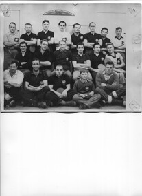
Photo - McKay Creek Table Tennis Club
... McKay Creek Power Station... Creek was the site of a power station where the employees lived ...During the construction of the Kiewa Hydro Electric Scheme the employees socialised by joining clubs such as the table tennis club.McKay Creek was the site of a power station where the employees lived in the camp while working there. Table tennis entertained them during their leisure time. This activity is of historic and social significance and can be compared with activities of today especially as Mt Beauty was built as a construction town for the Kiewa Hydro Electric Scheme and is now a small town with the added influence of tourism. McKay Creek was part of the construction with a work force living there.Large Black and white photo of the McKay Creek Table Tennis Club including 18 men and 1 boy.ID on the back and "AM Collection"mckay creek power station, table tennis club, kiewa hydro electric scheme -
 Kiewa Valley Historical Society
Postcard - Mt Beauty and the Kiewa Hydro Electric Scheme
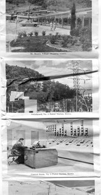
... Power station... Power Station, Kiewa 4. Generators, No. 3 Power Station 5... station generators Mt Beauty turbines Junction Dam switchyard ...SECV constructed the Kiewa Hydro Electric Scheme including the township of Mt Beauty. The area became a popular tourist destination.Tourism in the Kiewa Valley especially at Mt Beauty and the Bogong High Plains along with the Kiewa Hydro Electric Scheme became very popular and an important industry.Fold out b & w postcard with 12 photos back to back. All with a title. Kate 1950s 1. High Voltage Transmission Line, showing Mount Beauty Township 2. Clover Dam Reservoir, Kiewa 3. No. 3 Power Station, Kiewa 4. Generators, No. 3 Power Station 5. Turbines, No. 4 Power Station, Kiewa 6. junction Dam, Bogong 7. Mt Beauty Village Shopping Centre 8. Switchyard, No. 4 Power Station, Kiewa 9. Control Room, No. 4 Power Station, Kiewa 10. Winter Scene at Rocky Valley on the Bogong High Plains 11. Water Channel, Mt Bogong in Background 12. Mt Beauty Township, Kiewa Valleytransmission line, power station, generators, mt beauty, turbines, junction dam, switchyard, rocky valley, control room -
 Kiewa Valley Historical Society
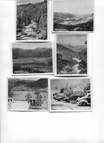
Photos - Kiewa Hydro Electric Scheme - Kiewa Valley
... Power Station... Bogong 8. No 3 Power Station ... Bogong Village Bogong High Plains Junction Dam Power Station 8 ...The SECV constructed the Kiewa Hydro Electric SchemePhotos showing the development and history of the Kiewa Hydro Electric Scheme8 small b & w photos. All with titles including "Kiewa Hydro Electric Project". They are in an envelope titled "Valentine's / Snapshots / Eight Real Photographs / Kiewa Valley / Published by /The Valentine Publishing Co. Pty. Ltd / Melbourne and Sydney 1. Kiewa Valley Panorama 2.The East Kiewa River 3. Road to Bogong High Plains 4. Mt Beauty Village 5. Snowfall Bogong Village 6. Bogong Village 7. Junction Dam Spillway, Lake Guy Bogong 8. No 3 Power Station mt beauty, bogong village, bogong high plains, junction dam, power station -
 Kiewa Valley Historical Society
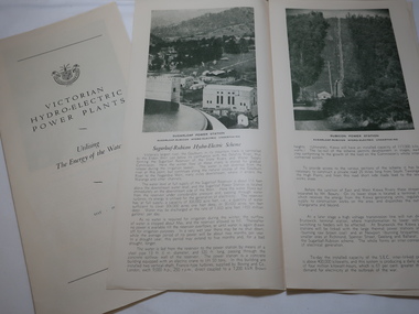
Leaflet - Victorian Hydro Electric Power Plants, Utilising The Energy of the Waters. May 1946
... No. 3 Power Station Kiewa Scheme... Station... No. 3 Power Station Kiewa Scheme White paper folded into 4 ...The SECV established in 1921 built many Power Plants including those on the Kiewa Hydro Electric Scheme.The article explains the power plants built on the Kiewa Hydro Electric Scheme.White paper folded into 4 panels with the cover including the SECV emblem and the titles .(3 copies). When unfolded the section beside the cover is a graph titled Kiewa Hydro Electric Scheme / Cross section of General Layout On the inside panel 3 is the title Kiewa Hydro Electric Scheme with a photo of No. 3 Power Stationpower plants, no. 3 power station kiewa scheme -
4th/19th Prince of Wales's Light Horse Regiment Unit History Room
Station Radio C13
... Station Radio C13... or as ground station. Consists three main units - the sender/receiver... for use in vehicles or as ground station. Consists three main ...Used by all Royal Australian Armoured Corps vehicles. Mid 1950's to mid 1970'sEquipment used by the RegimentA HF voice and CW sender-receiver for use in vehicles or as ground station. Consists three main units - the sender/receiver, the power supply unit, and aerial tuning unit. Power supply was either 12 or 24 volt. Frequency range 1.5 - 12.0 Mc/s. Operating range up to 25 miles.Radio - No 0549, Supply unit vibratory - No 1545, Aerial Tuning Unit No 1397radio, c13 -
4th/19th Prince of Wales's Light Horse Regiment Unit History Room
Book, User Handbook (Provisional) Wireless Station C13/C13 in Truck 1 ton
... User Handbook (Provisional) Wireless Station C13/C13 in..., operation. servicing and installation of Wireless Station C13/C13.... servicing and installation of Wireless Station C13/C13 in Truck 1 ...Soft covered book detailing a general description, operation. servicing and installation of Wireless Station C13/C13 in Truck 1 Ton GS 4x4 Mk 1 or Mk 2 Austin K9SRDE Handbook No 999 (Prov)radio c13, handbook -
4th/19th Prince of Wales's Light Horse Regiment Unit History Room
Book, User handbook for Station Radio C13, Nov 1960
... User handbook for Station Radio C13... and user servicing of Station Radio C13... of Station Radio C13 User handbook for Station Radio C13 Book Signals ...Soft covered book detailing general description operation and user servicing of Station Radio C13WO Code 12289radio c13, handbook -
4th/19th Prince of Wales's Light Horse Regiment Unit History Room
Document, Operator's Drills and Tests for Station Radio C13, 1960's
... Operator's Drills and Tests for Station Radio C13... for the radio station C13... station C13 Operator's Drills and Tests for Station Radio C13 ...Photocopy of book detailing the drills and tests for the radio station C13WO Code 9792radio c13, drills and tests -
4th/19th Prince of Wales's Light Horse Regiment Unit History Room
Book, User Handbook for Wireless Station No C42, Dec 1955
... User Handbook for Wireless Station No C42..., operation and user servicing of the wireless station C42.... servicing of the wireless station C42. User Handbook for Wireless ...Handbook for equipment once used by the RegimentSoft covered book detailing a general description, operation and user servicing of the wireless station C42.WO Code No 11197. December 1955handbook, radio, wireless, c42 -
4th/19th Prince of Wales's Light Horse Regiment Unit History Room
Manual - Folder, loose leaf, User Handbook for Station Radio C13/User Handbook for Wireless Set B47, Nov 1960, Mar 1957
... User Handbook for Station Radio C13/User Handbook for...WO Code No 12289 Station Radio C13 November 1960 WO Code... handbook c13 b47 WO Code No 12289 Station Radio C13 November 1960 ...The C13/B47 radio combination was used in the unit's vehicles in the 1960's.Used by the RegimentPhotocopy reproduction of the user handbooks for RS C13 and WS B47, detailing a general description, operation, and user servicing of both sets enclosed in a loose leaf folder. WO Code No 12289 Station Radio C13 November 1960 WO Code No 11791 Wireless Set B47 March 1957radio, handbook, c13, b47 -
4th/19th Prince of Wales's Light Horse Regiment Unit History Room
Manual - Folder, loose leaf, Technical Manual User Handbook for Single Channel Radio System HF Vehicle ground stations & VHF vehicle and ground stations
... the vehicle and ground stations configurations of RAVEN Radio Systems... and ground stations configurations of RAVEN Radio Systems HF RT-F100 ...Used by the RegimentHard covered loose leaf folder containing the Technical Manuals and User Handbooks for both radio systems, covering the vehicle and ground stations configurations of RAVEN Radio Systems HF RT-F100 and VHF RT-F200, detailing general description, operating instructions and operator servicing for both systemsNSN 7610-66-130-4108 HF NSN 7610-66-130-4109 VHFradio, handbooks, rt f100, rt f200 -
4th/19th Prince of Wales's Light Horse Regiment Unit History Room
Manual - Folder, loose leaf, Technical Manual User Handbook for Single Channel Radio System HF Vehicle and Ground Stations, 1990's
... covering the vehicle and ground stations of the RAVEN Radio System... Channel Radio System HF Vehicle and Ground Stations 1989... Stations 1989 Stapled photocopy of the Technical Manual User ...Relates to equipment used by the RegimentStapled photocopy of the Technical Manual User Handbook covering the vehicle and ground stations of the RAVEN Radio System HF RT-F100 detailing a general description, operating instructions and operator servicing, including amendment No 1 of Apr 1990. Copy is poor quality in some areas, particularly in areas that are red in originalAustralian Army. Technical Manual. User Handbook for Single Channel Radio System HF Vehicle and Ground Stations 1989radio handbook, raven, hf rt f-100 -
 Kiewa Valley Historical Society
Photo - McKay Pipeline
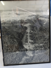
... No 1 Pipeline McKay Power Station... Power Station, is above the ground going down the mountain.... Hydro Electric Scheme. It begins at the McKay Power Station ...The McKay pipeline was built by the SECV during the construction of the Kiewa Hydro Electric Scheme. It begins at the McKay Power Station, is above the ground going down the mountain.The McKay pipeline was built by the SECV during the construction of the Kiewa Hydro Electric SchemeBlack and white large photo of Mt McKay's pipeline going down the mountain. It has a black plastic frame.no 1 pipeline mckay power station -
 Kiewa Valley Historical Society
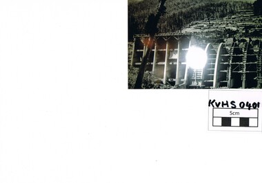
Photograph Junction Dam, Photo Junction Dam and Bogong Village in Background, circa 1950s
... driven power stations. However time has demonstrated ...This item clearly shows the conditions covering both working conditions and housing in the construction of the Junction Dam in the 1940s. Working conditions were extreme and health and safety legislation was at its infancy. The residential buildings were intended to last only for the period of construction, however greater demand for longevity as a tourist haven prevailedThis photo of the construction of the Junction Dam, with The Bogong village as backdrop, details the harsh conditions faced by construction workers, building dams and villages to accommodate workers in the 1940s to the 1950s. Australia at this period in time, experienced a surge of population (influx of World War II refugees), which was the catalyst for developing and undergoing an enormous hydroelectricity program for the Alpine regions, both in Victoria and New South Wales. This program was initiated to supply electricity to the major southern Australian cities of Adelaide, Melbourne and Sydney. It was thought that these developments would reduce, if not eliminate, the requirement for coal driven power stations. However time has demonstrated that these power stations have not matched the demand required by the industries and the populations of the major urban and cities.Black and white photo of original photo with a flashlight reflection in the bottom centre. The photo is on Kodak XtraLife II paper. The paper is semi gloss.This photo is of the construction of the Junction Dam Wall with the Bogong Townshiip in the background.Back of photo is printed " Kodak XtraLite II paperdam construction, bogong village, alpine development, junction dam -
 Kiewa Valley Historical Society
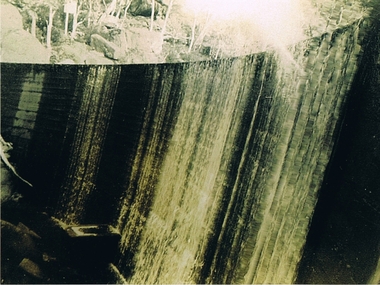
Photograph Clover Dam, Clover Dam Circa 1940, circa 1940s to 1950s
... Station. This was at the forefront of sustainable "Green" energy... mega watts) at the West Kiewa Power Station ...As part of the push to cut electricity costs and diversify supply, the Victorian Government (circa 1930) implemented the conversion strategy from mainly brown coal supply to hydro - electricity. The Kiewa Hydroelectric Scheme became the largest scheme of its kind in the State Of Victoria and the second largest scheme in Australia. This dam was constructed to supply water to feed four turbines (62 mega watts) at the West Kiewa Power Station. This was at the forefront of sustainable "Green" energy. Costs associated with power supplies is still a major incentive of governments, however environmentally friendly alternatives such as wind and nuclear have also made inroads. The Kiewa valley and its surrounding alpine catchment were looked at(Victorian State Government), from the beginning of the twentieth century as a source of alternate power for an every increasing demand for electricity by growing population and heavy industrial ares within Melbourne City and State regions. Construction of dams, such as Clover Dam provided the large quantity holding areas of water required to turn the turbines at the various power stations to provide the electricity needed. The impact of these controls by moderating water run off from the alpine regions is beneficial in reducing flooding from thawing of snow on the alps. This by-product allows agriculture and grazing to be less vulnerable to seasonal flooding thereby resulting in a more stable annual production level.Reproduction (scanned) of a black and white photo of Clover Dam circa 1940. The paper used is KodakXtraLife II paperThe reverse side of photo " KodakXtraLife II paperdams, pondage, hydro electricity, power stations, clover dam, secv -
 Kiewa Valley Historical Society
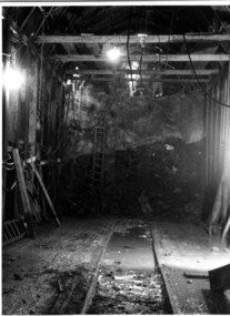
Photograph Tailrace tunnel Arch Drive, Tunnel face at Tailrace showing Arch Drive, between 1943 and 1952
... power station... tunnel between West Kiewa Power Station and Mt. Beauty. Much... Kiewa Power Station and Mt. Beauty. Much of the area ...This photo was taking during construction of the tailrace tunnel between West Kiewa Power Station and Mt. Beauty. Much of the area was unstable and timber supports were erected prior to concreting. The tunnel was commenced in 1941 and completed in 1952. It brings water from the power station into the open tailrace at Mt. Beauty and then into the regulating pondage before discharge into the Kiewa River.Shows method of construction for supporting walls and ceiling of tunnel with timber, size of tunnel (note worker on upper level), and conditions in the work place during construction in the 1940's/50's - note the timber ladder to gain access to the upper level.Black and white photographHand written on back of photograph "Tunnel face at Tailrace showing Arch Drive".tailrace, power station, water, construction -
 Kiewa Valley Historical Society
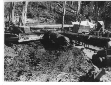
Photograph, logging at McKay Creek, Logging at McKay Creek, c1950's
... Creek Power Station. Excavation of this site did... Station. Excavation of this site did not commence until 1951 ...This photograph was probably taken at the site of McKay Creek Power Station. Excavation of this site did not commence until 1951 but road access(a narrow track) was provided in 1948 and widened in 1954. The logs would have been milled for timber at the State Electricity Commission's mill at Howman's Gap and thus provided a much needed source of timber for construction of camps and houses as there was a general of shortage of this commodity. Because of trouble with landslides in this area, a decision was made to place the machine hall of the power station underground instead of on the surface. Restricted financial resources and the repositioning of the power station retarded construction activities and it was not completed until early 1961.. An excellent pictorial record of the general working conditions, type of machinery and vehicles in use in the 1950/s.Black and white photograph showing logging equipment, fallen logs.Handwritten on the back of the photograph "Logging at McKay Creek)logging, mckay creek, timber, machinery -
 Kiewa Valley Historical Society
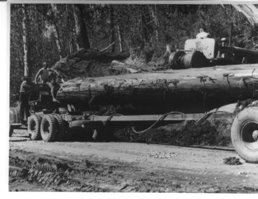
Photograph, logging at McKay Creek, Logging at McKay Creek, 1949/50
... of the proposed McKay Creek Power Station. Excavation of this site... Station. Excavation of this site was commenced in 1951 ...This photo was most likely taken at the site of the proposed McKay Creek Power Station. Excavation of this site was commenced in 1951 but an access road (a rough, narrow track) was put it in 1948 and widened in 1954. The State Electricity Commission would have milled logs from this area at their mill at Howman's Gap. The timber was used for building of housing and camps and provided a much needed resource as there was a general shortage of this commodity. The power station was relocated underground owing to repeated problems with landslides in the area. Restricted financial resources and the repositioning of the power station retarded construction activities and it was not completed until early 1961. An historical pictorial record of the type of machinery used in the 1950's - logging truck with bogie attached, the bull dozer and winch for hauling logs to the truck and note the lack of protective clothing!Black and white photograph showing a logging truck, bogie and bull dozer with winch for hauling the logs to the truck. Two men are on the truck, a driver on the bull dozer and a large log on the bogie. Hand written on the back of photo "Logging at McKay Creek".logging, mckay creek, timber, machinery -
 Kiewa Valley Historical Society
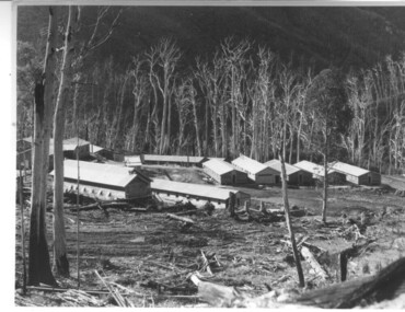
Photograph of Howmans Dam Camp, Howmans Dam Camp, circa 1948
... supplied water for No. 2 Power Station at the Junction... water for No. 2 Power Station at the Junction of the Pretty ...Howman's Gap camp was erected in 1948. The proposed dam to be built at this site was postponed in 1954 because of financial restraints imposed by the government at this time. It was to have supplied water for No. 2 Power Station at the Junction of the Pretty Valley and Rocky Valley branches of the East Kiewa River. This power station was not constructed until 2008 - 2010 and now gets it water from McKay Creek Power Station. The site of this camp is now occupied by the Howman's Gap Alpine Centre. Some of the original buildings still remain. An excellent photographic record of the type of buildings and size of the camp for accommodation of workmen during construction of the Kiewa Hydro Electric Scheme.Black and white photograph of the buildings erected at Howmans Dam site as accommodation for workmen.Handwritten in blue ink on the back of photograph "Howmans Dam Camp"howman's gap, camp, water, dam -
 Eltham District Historical Society Inc
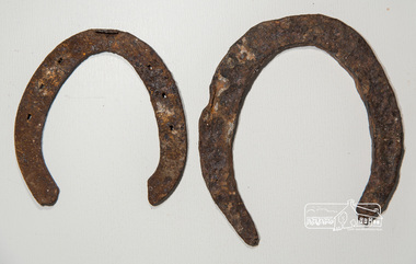
Horseshoe, Two horseshoes, c.1860, 1860s
... police station... of the property adjoining the former Eltham Police Station and Court House ...ELTHAM POLICE QUARTERS & REAR STABLE (FORMER), is listed on the Victorian Heritage Database. The stables are described: "The original single stall brick stables building with loft, built in 1859-60.."These horseshoes were dug up by the owners of the property adjoining the former Eltham Police Station and Court House site behind the stables when working in their garden. Presumably they were discarded adjacent to the stables where the Police horses were kept and over time became covered with soil and other material. They were presented to the Society by the owner during the Local History Centre Open Day held for the Society's 50th anniversary 4 March 2017.Two iron (rusty) horsehoes, one significantly larger than the other; the larger shoe appearing to be not fully manufactured as no nail holeshorseshoe, police residence, police station, brougham street, eltham