Showing 2050 items matching " building plans"
-
 Eltham District Historical Society Inc
Audio - Audio Recording, Audio Recording; 2018-10-13 Eltham Community Town Hall Meeting, 13 Oct 2018
Meeting to discuss the Nillumbik Shire Council's proposed sale and devlopment of the former Shire Office site at 895 Main Road as well as the Eltham War Memorial including the Maternal and Infant Welfare Centre, Eltham Pre-school and Eltham War Memorial Hall and Memorial Gardens at 903-907 Main Road which also includes thje Eltham Senior Citizen's Centre. The meeting was attended by more than 300 people which considered the following: Motion from public meeting – Saturday 13th October, 2018 1. This meeting has no confidence in Nillumbik Shire Council's proposed process for the re-development of 895 and 903-907 Main Rd, Eltham and we deplore the cursory attention given to public consultation to date. 2. We call on Council: *to preserve the Eltham War Memorial building complex at 903-907 Main Rd, Eltham, and retain their existing uses in accordance with the Eltham War Memorial Trust purpose; and retain the Cenotaph and Eltham Senior Citizens' Centre. * to retain council ownership of all land at 895 and 903-907 Main Rd, Eltham for our community and future generations. * following meaningful engagement with residents of the Shire, to place sufficient planning controls on the site of the former Eltham Shire Office to ensure that any future development of that land responds to Eltham's form and character and properly protects public amenity, access and use. * to make all proposals for the development of 895 and 903-907 Main Rd, Eltham available for public inspection as soon as they are received by Council. Moved: Greg Johnson Seconder: Andrew Lemon * carried unanimously1:28:52 duration Digital MP3 File 30.5 MB 895 main road, 903-907 main road, community meeting, eltham pre-school, eltham shire office, eltham war memorial, eltham war memorial hall, infant welfare centre, nillumbik shire council, senior citizen's centre -
 Eltham District Historical Society Inc
Audio - Audio Compact Cassette Tape, Harry Gilham, Audio Recording; Eltham Library History presented by Harry Gilham, 1994
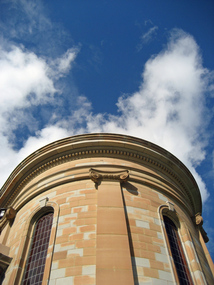
The new Eltham Library was opened 22 May 1994 and celebrates its 30th anniversay in 2024. This audio recording, presented by Harry Gilham, President of Eltham District Historical Society at the time of the opening is a summarised history of the Eltham Library service to 1994. Eltham Library Service 1930s - 1994 Originally collated by Harry Gilham, President, Eltham District Historical Society Inc (1993-2009) (edited 2022) In the Eltham township area, in the early 1930s, library books for adults were available from E J Andrew's newsagency in Main Road. In the newsagency come haberdashery, some shelves were set aside for a lending library of adults' books. In 1935, Mr & Mrs JC Rains purchased the newsagency and continued the lending service until the late 1940s. At this time the business was extended from haberdashery to sell ladies' and men's clothing. The library section was discontinued. In the 1930s a mobile book library was also run by a Mr Foster of Bible Street, Eltham. In the 1950s adult books were available from racks in the foyer of the Eltham Shire Offices which was then located beside the Eltham Hall on the comer of Arthur Street and Main Road. In the early 1950s a referendum of ratepayers was called to seek public opinion on the issue of raising money for a public library for which the rates would have to be increased - the motion was defeated. On 11 November 1965 Eltham Shire Council, in conjunction with the City of Heidelberg and the Shire of Diamond Valley, met to form the Heidelberg Regional Library Service. Eltham was represented by Councillors Charis Pelling and John Lewis. The first library service for the Shire of Eltham from this group came in the shape of a bookmobile van which had, amongst others, a central stopover near the Shillinglaw trees outside the newly opened Shire offices at 895 Main Road, the original site of Shillinglaw Cottage and the former Shillinglaw farm. Present-day Wingrove Park was another stopover and the many recorded requests for this service can be read as denoting the areas of population or gathering points at that period throughout the Shire. 1968 saw the Shire convert the ‘Brinkkotter’ house in Dudley Street to house both adult and children's books. This library was originally staffed from the City of Heidelberg Library and records of committee meetings range from borrowing Heidelberg's old library shelving to trying to increase the Government's subsidy to a dollar for dollar basis. Book loans in the period 1966-67 totalled 30,400 and the following year ran to 52,113. With 2 books plus 1 paperback the limit per person, it was overcrowded and unable to house the range of other services which had become common library stock. Planning to extend the Shire Offices by the addition of the south wing was an opportunity to re-house the Shire's Library. The opening of the library in the extension was carried out on 17th August 1971 by the Hon R J Hamer ED, MP, Chief Secretary of Victoria. Cr Geoffrey Dreverman officiated as the Shire President. The Heidelberg Regional Library Service continued until September 1985 when it disbanded. On 21 November 1985 the Yarra Plenty Regional Library Service was established. At that time Eltham was represented by Councillors Mary Grant and Robert Manuell. By 1987, over-crowding of the Eltham Library and an inability to house the range of other services yet again rose to prominence. At a Council meeting held on 1 June 1987, the Councillors supported a resolution which threatened to close the library on 30 September 1987. Council's frustration arose from yet another re-run of the annual State Government versus Council Library funding and records show first arose in Eltham Council in 1967 with the Government of 1he day. After prolonged public anger and petitions the motion to close the library was rescinded in August 1987. Council, considering the community's concern, set up a ‘Library Review Working Party’ which a year later became the Library Occasional Committee with direct access to Council. This Committee investigated the workings of the 386 square metre library and found inadequate space for storage and display, lack of equipment, out-of-date furniture together with an increasing patronage which resulted in queues of borrowers becoming longer no matter when the library was open. Community consultation took the form of 1,000 questionnaires sent to users and non-users along with noticeboard reminders of what was planned. Council developed a strategy to set aside capital funds from 1988 on an annual basis so that preliminary planning and consultative expenses could be met, and construction could be completed early 1997. The Committee visited metropolitan libraries which were catering for a similar population as was projected for Eltham. Australia-wide Federal Government funding grants under the Local Capital Works Program became available from October 1992 for community projects endorsed by local Councils. The Eltham Council submitted a proposal, based on library findings and requirements accumulated by the Library Occasional Committee, to the Federal Grants Committee to build a new Eltham Library. The Federal Grants Committee supported the funding request allowing commencement of the library project three years earlier than planned. With finance finalised, the Council set up its Eltham Library Re-development Special Committee which was given the task of overseeing what could be the last major expansion of the Shire's Library Service as Eltham's population nears its projected maximum. The new library was designed by Gregory Burgess and Peter Ryan of Gregory Burgess Pty Ltd. Construction of the library commenced in 1993 and was officially opened May 22nd, 1994. The library building was designed to reflect its parkland setting. External features include: the roof which includes interesting aspects when viewed from Main Road; verandahs which provide ramp access and give a sheltered entrance to the building; walls which feature locally made mudbricks, conventional bricks and copper panels; and space for an outdoor courtyard/reading area which will be developed later. Internally there are several features. The building includes a foyer with a fireplace suitable for displays including artwork, a community multi-purpose room suitable for meetings or functions and an outdoor cafeteria. The ceilings are lined with Victorian Ash. The shapes for the ceiling give a free-flowing form to the building. Brush Box has been used for the circulation and information desks. The tree trunk columns are Grey lronbark from New South Wales. Arches and various-shaped windows add interest to the internal structure. The carpet design reflects the Eltham environment and compliments the natural colours and timbers used in the building. Tiles by artist Felix Bosari feature in the building and additional art by local artists added externally and internally to the building. Since 1994 the library has undergone a major extension to cater for children’s services and others. See also EDHS_02111Digital file only recorded from Audio Cassette tape on loan Converted to MP3 file; 11.1MB, 0:08:49eltham library, opening, harry gilham, harry gilham collection, 1994, audio cassette, audio recording -
 Eltham District Historical Society Inc
Work on paper - Folio, Register of Significant Trees, Shire of Eltham, c.1993
In 1983, the National Trust advised the Shire of Eltham that it was investigating a number of trees within the shire which had been nominated for recording the Register of Significant Trees of Victoria. The trees involved were described in the Shire of Eltham Historical Society Newsletter No. 29, March 1983 as follows:- 1. Eucalyptus melliadora (Yellow box) . a) An outstanding mature specimen 42 metres high in Laughing Waters Road, Eltham. b) Another mature specimen in Arthurs Creek road, Hurstbridge is reported to be the tree under which the bushranger Robert Bourke was tied after he shot and killed Henry Hurst in 1866 . 2. Quercus robur (English Oak). a) "Donaldson's Oak", Donaldsons Road, Kangaroo Ground was planted by John Donaldson from seed collected from Windsor Great Park in 1878. b) "Wippells Oak". This now misshapen tree is located on the St. Andrews Road near the Kangaroo Ground Fire Station. Its origins may have been similar to Donaldson's Oak, and as a young tree it apparently slipped from higher up the hill during wet weather. Both oaks are of local historical importance. 3. Eucalyptus globulus (Blue Gum). A large mature specimen at the corner of the Kangaroo Ground-St. Andrews Road and Bakehouse Road, Panton Hill. 4. Plantanas acerifolia (Plane tree) A number of trees forming the Avenue of Honour to Eltham's First World War soldiers along Main Road between Dalton and Pitt Streets, Eltham. 5. Pinus canariensis (Canary Island Pine), Pinus pinea, (Stone pine) and Cedras altlantica, (Cedar) These trees are located at the Hurst family graves in the grounds of the Hurstbridge Pre-school Centre. In 1991 the Shire of Eltham introduced controls into its planning scheme to protect sites of architectural, historic or conservation interest and significant trees. The controls were approved by the Minister for Planning and Housing. As advised in the Shire of Eltham Historical Society Newsletter No. 78, May 1991, a planning permit is required to demolish or alter any listed building or to destroy, lop or remove any listed tree. Provision is made for comments to be obtained from the National Trust or Historic Buildings Council in considering any applications. The buildings and trees listed were: Buildings: 250 Bolton Street Eltham (former Walter Withers home) "Rosehill" - Bonds Road Lower Plenty St Andrews Church of England - St Andrews "Montsalvat" - Hillcrest Avenue Eltham St Margarets Church and former vicarage - Pitt Street Eltham Presbyterian Church - Kangaroo Ground Parks and Environment Office (former police quarters) Main Road Eltham Former Court House - Main Road Eltham "Shillinglaw Cottage" - Main Road Eltham "The Robins" - Kangaroo Ground Road Warrandyte Trees: "Donaldsons Oak" - Donaldsons Road Kangaroo Ground Yellow Box - Laughing Waters Road Eltham Yellow Box - Arthurs Creek Road Hurstbridge Wippells Oak - St Andrews Road Kanqaroo Road Pines and Cedar - Hurst family cemetery Greysharps Road Hurstbridge Yellow Box - Parsons Road Eltham A large Blue Gum at Panton Hill has been listed but has recently died (1991). In 1993 work by Council Parks and Environment staff and volunteers resulted in the preparation of a Significant Tree Register listing forty-one trees or groups of trees. According to Shire of Eltham Historical Society Newsletter No. 91, March 1993, a similar number remained to be assessed for inclusion in the register. There is a wide range of indigenous and planted trees on private and public land and extending through the Shire of Eltham from Lower Plenty to Kinglake. Most can be viewed from publicly accessible locations. The Significant Tree Register lists 41 trees or groups of trees throughout the Shire. It contains a wide range of naturally occurring and planted trees. They have been assessed according to eleven criteria including size, age, rarity, historical value and the like. The list includes large old Red Gums at Lower Plenty, historic Oaks at Kangaroo Ground and Mountain Ash at Kinglake. The register includes a set of slides showing each tree. Garry Bartlett of the Council's Parks and Environment Section and Faye Shepherd were extensively involved in establishment of the register (Newsletter No. 93, November 1993). In 1999 Niliumbik planners prepared an amendment to the Planning Scheme to provide protection for approximately 200 of the places listed in the heritage studies and also in the Significant Tree Register commenced by the Eltham Council (Eltham District Historical Society Newsletter No. 127, July 1999. In 2004, The Register of Significant Trees was presented to the Eltham District Historical Society by Nillumbik Shire Council as part of a wider collection of of its memorabilia of the former Eltham Shire Council (EDHS Newsletter No. 159, July 2004. Album of loose handmade paper sheets contained within a handmade slip cover constructed of handcrafted card with encapsulated flora material (flowers, vines, ferns) and tinted. Each page also contains an embedded/adhered fern leaf also tinted with lacqueur or similar, text as appropriate in ink by hand calligraphy. Each page also has a white protective sheet cut to size and adhered to back surface with sticky tape and folded over face of page. Pages variously have photographs and coloured masks adhered with a gum resin. Over time much of this resin has let go and photos/masks have been reattached using acid free archival safe adhesive. 15 pages 41 x 29 cm inclusive of 3 blank pages. Slip case 42 x 30 x 1 cm; face cover of slip case has broken off at left hand margin as insufficient depth/flexibility for contents.arthurs creek road, blue gum (eucalyptus globulus), canary island pine (pinus canariensis), couties road, donaldsons oak, donaldsons road, eltham, english oak (quercus robur), eucalyptus melliodora, graysharps road, hurst tree, hurstbridge, ironbark (eucalyptus tricarpa), ironbark hill, kangaroo ground, kangaroo ground-kinglake road, laughing waters road, panton hill hotel, panton hill, parsons road, significant trees register, sonia van bodegraven, sonjart, stone pine (pinus pinea). atlantic cedar (cedrus atlantica), wippells oak, yellow box gum (eucalyptus melliodora), yellow box gum -
 Lakes Entrance Historical Society
Book, Ellem, Elizabeth Wood, Victoria Felix A celebration of the 50th Parliament of Victoria 1856-1985, 1985
A History of the system of government in Victoria, from the first Parliament in 1856 until the 50th. Parliament in 1985. Illustrated with sketches, plans and photographs.history, government, buildings, politics -
 University of Melbourne, Burnley Campus Archives
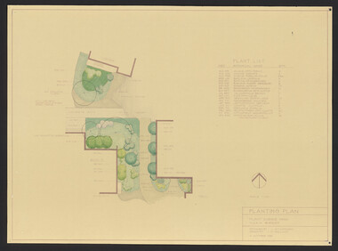
Plan, Student Amenity Building (Citriodora) Courtyard, 1988-2000
... ) Planting Plan Plant Science Area V.C.A.H. Burnley designed by J...) Planting Plan Plant Science Area V.C.A.H. Burnley designed by J ...Various plans for what is now known as the "Citriodora Courtyard." I copy tracing paper, 1 coloured original, 4 copies with additional notation 6 smaller copies with additional notation. (1) Planting Plan Plant Science Area V.C.A.H. Burnley designed by J. Hitchmough, drawn by S. Mullany 3 October 1988. (2) Student Amenity Quad Sketch Proposal by M. Green May '95. (3) Rough pencil design, New Design related to Horticultural pursuits of Burnley College. (4) Coloured, Proposed Citriodora Court Redevelopment. (5) 2 copies Citriodora Courtyard Presentation Concept Plan by Adrian Bonifacio. November 2000. (6) Landscape Graphics II Assoc. Diploma in Horticulture (Amenity) Assignment 2 - Planting Plan May 1988. (7) Laminated, Preliminary Plan 2 of 4 Citriodora Lawn Burnley by Kate Szmal B.A.S.H. (8) Laminated, Preliminary Plan Student Amenity Building Courtyard V.C.A.H. Burnley by Caroline Lodge. (9) 1 tracing paper and 1 paper copy University of Melbourne Burnley College Student Amenity Building Courtyard 19.8.99. (10) Setout Plan, Planting Plan & Surface Finishes, Details Courtyard & Entrance, ACM Landscape Architecture: Concrete Paving Topsoil, Mulch - notes. "Phil Tulk," handwritten on reverse. (11) Laminated, V.C.A.H. Preliminary Plan p3 of 5 Project No 1 Student Amenity Building Courtyard by K. Watson 15-8-95. (12) Citriodora Courtyard Redevelopment Concept Plan by Judy Brookes November 2000. 2 copies of Drawing 1 of 2, 1 copy Drawing 2 of 2. (13) Proposed Outdoor Eating Area Student Amenities Block: Scheme 1 pp 2-5 of 5, 16.10.96. Scheme 2 pp 3-5 of 5, 16.10.96. Scheme 8 3 copies p1 of 2, 2 copies p2 of 2, 23.6.97, Paving Types p1 of 1, 30.9.99, handwritten on reverse,"to Phil from Nicki." (14) 2 copies Entry from Rear Car Park Paving Plan. (15) Plan by Margaret Kitching 8.8.90. citriodora courtyard, vcah, centenary courtyard, plant science area, k. watson, s. mullaney, j. hitchmough, judy brookes, kate szmal -
![Booklet, Historic Buildings Preservation Council, Register of Historic Buildings [Victoria] 1982, 1982](/media/collectors/4f729f5697f83e03086015b8/items/6656e4f0cf65d0fdbb6d865f/item-media/66834abcfc20ebe8ca2a060d/item-fit-380x285.jpg) Greensborough Historical Society
Greensborough Historical SocietyBooklet, Historic Buildings Preservation Council, Register of Historic Buildings [Victoria] 1982, 1982
The Register of Historic Buildings was set up in 1974 and is added to or amended by the Minister for Planning on the recommendation of the Historic Buildings Preservation Council. This version 1982.21 pages of duplicated typescriptnon-fictionhistoric buildings victoria, heritage sites -
 Ringwood and District Historical Society
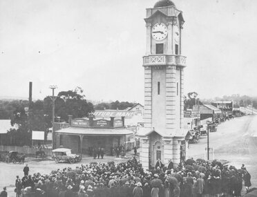
Photograph, Opening of clock tower by Mayor W. Mackinlay in August 1928
Age (Melbourne, Vic. : 1854 - 1954), Monday 6 August 1928, page 9 ________________________________________ RINGWOOD WAR MEMORIAL CLOCK TOWER UNVEILED A CIVIC CEREMONY. The people of Ringwood have erected a beautiful stone clock tower at a cost of £1797, as a memorial to those who served in the war. The unveiling ceremony was performed by the mayor of Ringwood (Cr. W. Mackinlay) on Saturday. “Bleak conditions with showers intervening prevailed at Ringwood on Saturday afternoon, when the unveiling ceremony of the soldiers' memorial clock tower, performed by the mayor (Cr. W. Mackinlay) took place in the presence of a Iarge and representative gathering. The ceremony was solely a civic one. A majority of members of the local branch of the R.S.S.I.L.A. had wished that Sir John Monash be invited to take a prominent part in the proceedings, but the trustees elected otherwise. The Salvation Army band from Box Hill rendered suitable music, while Sergeant E. P. Taylor (37th Battalion, A.I.F) sounded the Reveille and The Last Post impressively. Among those present were Mr. Edgar, M.L.C., the vicar of Ringwood (Rev. E. E. Robinson), Rev. G. McLaren (Methodist), the memorial trustees (Cr. J. B. McAlpin, Messrs, J. W. Barrett, A. H. Locke, J. A. Williams and A. G. Ashley). The last two mentioned are president and honorary secretary respectively of the local branch of the R.S.A. Soldier delegates from Camberwell and Mitcham were also present. At the outset the mayor said a few words would not be amiss concerning why the memorial had been so long delayed in being erected. In September, 1919, a public committee was formed, with Mr. A. V. Greenwood as chairman, to consider the erection of a suitable memorial to the soldiers. Among the more important suggestions had been the building of a hall and clubrooms on land generously offered by Mr. R. W. Dawes. This project had been abandoned, also the proposed erection of a huge memorial building, at a cost of £5000, on the site of the present town hall. As two years had passed without anything of a definite nature eventuating it was decided to elect five trustees, comprising three citizens and the president and secretary of the Returned Soldiers' Association with full power to act. In all propositions the trustees had been faced with financial difficulties, but about the time of the completion of the plans of the memorial tower Ringwood became a borough, and the new council was appealed to, and provided £500 to make the erection of the memorial possible. The architect, (Mr. H. Norris) had refused to take anything beyond out-of-pocket expenses (£16), while the engineer (Mr. Lucas) had saved a goodly sum by supervising the work. The total funds at the disposal of the trustees, including the council's donation, was, in round figures £1807. The tower complete would cost £1690; honor roll, £77, and fees paid for various designs had amounted to £30. The total expenditure was £1797, leaving a credit balance of £10. Before the unveiling the mayor, in again addressing the citizens, said he deemed it a privilege to perform such a task in connection with so splendid a memorial. The citizens had erected it as an expression of heartfelt gratitude in memory, first of all, of those heroes who gave not only their services, but their lives, when the call came in the common cause of right and liberty, upon which the British Empire was built. This memorial was also the tribute of the citizens in a degree of appreciation to those men who so un-selfishly and ungrudgingly volunteered their services in the Great War. The memorial, while commemorating the glorious deeds of Australian manhood, was not intended, in any sense, as a glorification of war. The memorial would tend to bring to one's mind the blessing of peace in contrast to the curse of hostilities. They were gathered there that afternoon to do honor to all those who volunteered for service to the Great War, but they wished to assure the friends and relatives of those who paid the supreme sacrifice of their sincere sympathy and trust. If ever in the future this fair southern land of ours was threatened by an invader he felt sure that Australian manhood would not hesitate to rally to the call to duty and defend the freedom of their country. Following prayer by Rev. G. McLaren (Methodist), the memorial clock tower was unveiled, the acting mayoress (Mrs. Mackinlay) cutting the cord, after which the making over of the memorial to the borough council took place, the president of the local branch of the R.S.A. (Mr. J. A. Williams) stating he had pleasure in accepting the key on behalf of the trustees. As the council was the permanent governing body the key would be handed back to the mayor, the memorial being given into the safety and custody of the council. During the proceedings the hymns O God, Our Help in Ages Past and Lest We Forget were rendered, the choirs of various denominations joining in the singing. Benediction was pronounced by the vicar of Ringwood (Rev. E. E. Robinson).” Black and white photograph (2 copies- one original mounted on cardboard backing)Written on rear of backing of original: "Opening of clock tower by Mayor W. Mackinlay, 4.8.1928." Written on back of copy" "Mayor Mackinlay dedicating Ringwood clocktower in original position at end of Warrandyte Rd. 1928. Maroondah Hwy on right." -
 Bendigo Historical Society Inc.
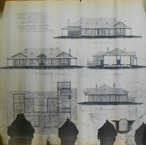
Plan - MARKS COLLECTION: PLAN ALBERT PARK SERPENTINE FOR G. LANSELL
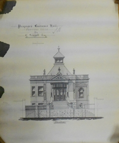
Copy of plan written on top LH corner: Proposed Homestead Albert Park Serpentine for H. Lansell Esq. Scale eight feet to one inch. W. Beebe & G.D. Garvin Architects, late W. Beebe, Mitchell St. Bendigo. Plan shows front, back and side elevation with floor plan for residence.buildings, house, albert park serpentine -
 Bendigo Historical Society Inc.
Document - MARKS COLLECTION: PLAN FORTUNA HOT WATER HEATING
Copy of plan: plan shows floor plan and design plans for hot water heating system to be installed in Fortuna Villa. Plans of basement and first floor. Heating unit construction detailed on plan. As plan has been copied, the stamp of the architect is indecipherable.buildings, house, fortuna villa -
 Bendigo Historical Society Inc.
Document - MARKS COLLECTION: PLAN OF FORTUNA VILLA ENTRANCE HALL
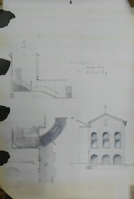
... Copy of plan: Written on top: Proposed Entrance Hall...BUILDINGS House fortuna villa Copy of plan: Written on top ...Copy of plan: Written on top: Proposed Entrance Hall, Fortuna Villa, for G. Lansell, Esq. Plan shows section of building, central staircase leading to front doors, double doors with side panels. Turret, with skylights on top. Signed on top: 'W. Beebe, Architect'.buildings, house, fortuna villa -
 Bendigo Historical Society Inc.
Document - MARKS COLLECTION: ALTERATIONS TO FORTUNA VILLA FOR G. LANSELL
... (not Villa) for G. Lansell Esq. Plan shows stairway, building...BUILDINGS House fortuna villa Copy of plan: Proposed ...Copy of plan: Proposed alterations to Fortuna House (not Villa) for G. Lansell Esq. Plan shows stairway, building. Scale 1/4 inch - 1 foot.buildings, house, fortuna villa -
 Bendigo Historical Society Inc.
Document - MARKS COLLECTION: COPY OF DRAWING OF FORTUNA
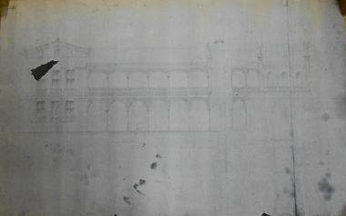
Photocopy of plan of Fortuna (front view) showing front and side elevation. On LH side of front elevation, 3 windows on first floor, two beneath at each side of door. In centre,6 arches in balcony, and 6 below. Good definition of verandah lacework.buildings, house, fortuna villa -
 Bendigo Historical Society Inc.
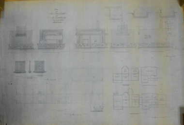
Plan - MARKS COLLECTION: PLAN OF ALTERATIONS TO FORTUNA VILLA
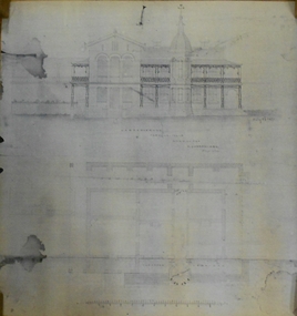
Copy of plan for alterations and additions to Fortuna Villa. Plan shows various elevations of Fortuna entry, plan of basement, ground floor (entry) and ceiling in entry. Signed by W. Beebe, Architect.buildings, house, fortuna villa -
 Bendigo Historical Society Inc.
Document - MARKS COLLECTION: PLAN FOR ALTERATIONS AND ADDITIONS TO FORTUNA
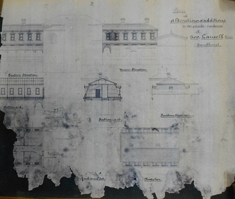
Copy of plan: Written on top RH corner of plan 'plan for alteration and additions to the private residence of Geo Lansell Sandhurst' Plan shows western, southern, and eastern elevations, plus roof plan. Bottom section of plan damaged. On bottom of plan '1/8 inch to one foot.'buildings, house, fortuna villa -
 Bendigo Historical Society Inc.
Plan - MARKS COLLECTION: FORTUNA PLANS
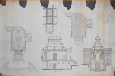
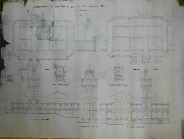
Copy of Plan: on top of plan 'Additions to Fortuna Villa for Geo Lansell Esq, scale 8 feet to one inch' Drawings of additions: ground plan, garden plan, second and third floor plan (mainly elevations).buildings, house, fortuna villa -
 Bendigo Historical Society Inc.
Document - MARKS COLLECTION: PLAN PRINCIPAL ENTRANCE FORTUNA VILLA AND GARDEN FRONT
2 copies of plans. 1. Smaller plan; written on plan Principal Entrance Front Fortuna Villa Sandhurst, G. Lansell Esq, Proprietor. Plan shows front entrance elevation, also floor plan of vestibule and verandah. 2. Large plan: written on plan Garden front, Fortuna Villa Sandhurst, G. Lansell, Esq. Proprietor dated July 3rd. 1871. buildings, house, fortuna villa -
Glen Eira Historical Society
Document - Grange Road, 77, Glen Huntly
This file contains 4 items about the purchase and construction of this property: 1/ The original contract of sale of land dated 25/09/1936 for Gertrude & Hulbert Gorrie situated on the corner of Grange and Neerim Road. 2/ The original typed building agreement dated 25/09/1936 between the contractor Ernest F Barnard and the purchasers Mr & Mrs Hulbert Gorrie. 3/ The original blueprint plan of a brick villa at the corner of Grange & Neerim Road for Mr & Mrs Hulbert Gorrie. Dated 25/09/1936. 4/ The original specification for the dwelling on the corner of Grange & Neerim Road, Glen Huntly for Mrs Gertrude Gorrie & Mr Hulbert Hopetoun Gorrie by builder Ernest F Barnard.barnard ernest f, gorrie gertrude, gorrie hulbert hopetoun, hobart john bertram, coorigil road, carnegie, holloway st, ormond, chemists, parish of prahran, caulfield county of bourke, building agreement, brick houses, builders, plans, architectural drawings, grange road, glen huntly, holloway street, ormond, emma street, grange road, neerim road, gorrie h.h, gorrie gertrude, gorrie hulbert h, legal documents, barnard ernest franklin, e. j. & h. amos, hintons nursery, real estate agents, murrumbeena, caulfield -
 Bendigo Historical Society Inc.
Plan - SANDHURST BOYS CENTRE COLLECTION: MASTER PLAN
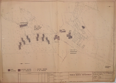
Government of Victoria. Public Works Department. Master plan for the Loddon-Campaspe Regional Service Sandhurst Centre. [produced by] J Swan Chief architect, approved by B.W. Swan. Shows a brick Administration building, 6 [accommodation?] brick buildings (to be remodelled), the site for a new kitchen & amenities building, TDU no 1, BMU, TDU no 2 (new buildings), sites for maintenance workshops, vegetable garden. Also shows a residence, garage, recreation oval, with 3 existing weatherboard buildings, galvanised iron building, a weatherboard grandstand, a galvanised iron shed, fowl shed, 14 galvanised iron buildings [probably Nissan huts] and 2 toilet blocks. Location unknown 16.02.2023.bendigo, institutions, sandhurst boys centre, victoria public works dept; plans; sandhurst boys centre; j.swan -
 Ballarat Heritage Services
Photograph - Digital photographs, L.J. Gervasoni, Xavier College Chapel, c2016, c2016
Xavier College was first opened by the Society of Jesus (the Jesuits) in 1878. It belongs to a worldwide network of over 2,000 Jesuit educational institutions. The original Senior Campus location on Barkers Road, Kew is a culmination of modern innovation and rich historical preservation. The land on which Xavier stands was known as Mornane’s Paddock and was purchased by the Jesuits in 1872 from Patrick Mornane on a 20-year interest-free purchase plan. This enabled the Jesuits to get on with the funding and building of the College buildings almost immediately. Foundations for the South Wing commenced in 1872, with the front of the building completed in time for classes to begin in 1878. Many of the first boarders transferred from St Patrick’s College in East Melbourne. With the closure of St Patrick’s years later, many students, associated lay staff and Jesuits also transferred to Xavier College. Over the following century, Xavier College grew with two junior campuses; Burke Hall Campus and Kostka Hall Campus. In recent years, extensive refurbishments, renovations and improvements have moulded the properties into the beautiful sites they are today. In 2002 at our Burke Hall campus and in 2005 at our Kostka Hall campus, the College expanded its educational program, opening Early Years centres to provide the scope for a Jesuit education from the earliest ages. For the first time in the College’s history, girls were admitted to the Early Years, breaking the long-standing tradition of Xavier being a boys-only school. In 2021, after 85 years of inspiring education experiences, our Kostka Hall campus closed its gates for the final time. In 1920, Archbishop Daniel Mannix donated the house and land known as Studley Hall to Xavier College for use as a preparatory school. The property had been purchased and donated to Mannix by Mr T.M. Burke, a Catholic businessman. In 1921, Xavier Preparatory School opened and was later renamed Burke Hall in 1926 in honour of Mr Burke. The Kostka Hall location was opened in 1937 and was named in honour of St Stanislaus Kostka. To establish the second preparatory school, the Jesuits purchased two Brighton properties in mid-1936. Both were promptly remodelled to provide the facilities required for school life. (https://xavier.vic.edu.au/xavier-history, accessed 15/05/2025) Colour photograph of the section of the Chapel at Xavier College, Kew, Victoria. heritage, kew, xavier college, chapel, catholic, st francis xavier, xavier chapel -
 Ballarat Heritage Services
Photograph - Digital photographs, Clare Gervasoni, Melbourne Views from Xavier College Chapel, 2025, 05/2025
Xavier College was first opened by the Society of Jesus (the Jesuits) in 1878. It belongs to a worldwide network of over 2,000 Jesuit educational institutions. The original Senior Campus location on Barkers Road, Kew is a culmination of modern innovation and rich historical preservation. The land on which Xavier stands was known as Mornane’s Paddock and was purchased by the Jesuits in 1872 from Patrick Mornane on a 20-year interest-free purchase plan. This enabled the Jesuits to get on with the funding and building of the College buildings almost immediately. Foundations for the South Wing commenced in 1872, with the front of the building completed in time for classes to begin in 1878. Many of the first boarders transferred from St Patrick’s College in East Melbourne. With the closure of St Patrick’s years later, many students, associated lay staff and Jesuits also transferred to Xavier College. Over the following century, Xavier College grew with two junior campuses; Burke Hall Campus and Kostka Hall Campus. In recent years, extensive refurbishments, renovations and improvements have moulded the properties into the beautiful sites they are today. In 2002 at our Burke Hall campus and in 2005 at our Kostka Hall campus, the College expanded its educational program, opening Early Years centres to provide the scope for a Jesuit education from the earliest ages. For the first time in the College’s history, girls were admitted to the Early Years, breaking the long-standing tradition of Xavier being a boys-only school. In 2021, after 85 years of inspiring education experiences, our Kostka Hall campus closed its gates for the final time. In 1920, Archbishop Daniel Mannix donated the house and land known as Studley Hall to Xavier College for use as a preparatory school. The property had been purchased and donated to Mannix by Mr T.M. Burke, a Catholic businessman. In 1921, Xavier Preparatory School opened and was later renamed Burke Hall in 1926 in honour of Mr Burke. The Kostka Hall location was opened in 1937 and was named in honour of St Stanislaus Kostka. To establish the second preparatory school, the Jesuits purchased two Brighton properties in mid-1936. Both were promptly remodelled to provide the facilities required for school life. (https://xavier.vic.edu.au/xavier-history, accessed 15/05/2025) Colour photograph of the Melbourne highrise from the Chapel at Xavier College, Kew, Victoria. heritage, kew, xavier college, chapel, catholic, st francis xavier, xavier chapel -
 Ballarat Heritage Services
Photograph - Digital photographs, Clare Gervasoni, Exterior Views of Xavier College, 2025, 05/2025
Xavier College was first opened by the Society of Jesus (the Jesuits) in 1878. It belongs to a worldwide network of over 2,000 Jesuit educational institutions. The original Senior Campus location on Barkers Road, Kew is a culmination of modern innovation and rich historical preservation. The land on which Xavier stands was known as Mornane’s Paddock and was purchased by the Jesuits in 1872 from Patrick Mornane on a 20-year interest-free purchase plan. This enabled the Jesuits to get on with the funding and building of the College buildings almost immediately. Foundations for the South Wing commenced in 1872, with the front of the building completed in time for classes to begin in 1878. Many of the first boarders transferred from St Patrick’s College in East Melbourne. With the closure of St Patrick’s years later, many students, associated lay staff and Jesuits also transferred to Xavier College. Over the following century, Xavier College grew with two junior campuses; Burke Hall Campus and Kostka Hall Campus. In recent years, extensive refurbishments, renovations and improvements have moulded the properties into the beautiful sites they are today. In 2002 at our Burke Hall campus and in 2005 at our Kostka Hall campus, the College expanded its educational program, opening Early Years centres to provide the scope for a Jesuit education from the earliest ages. For the first time in the College’s history, girls were admitted to the Early Years, breaking the long-standing tradition of Xavier being a boys-only school. In 2021, after 85 years of inspiring education experiences, our Kostka Hall campus closed its gates for the final time. In 1920, Archbishop Daniel Mannix donated the house and land known as Studley Hall to Xavier College for use as a preparatory school. The property had been purchased and donated to Mannix by Mr T.M. Burke, a Catholic businessman. In 1921, Xavier Preparatory School opened and was later renamed Burke Hall in 1926 in honour of Mr Burke. The Kostka Hall location was opened in 1937 and was named in honour of St Stanislaus Kostka. To establish the second preparatory school, the Jesuits purchased two Brighton properties in mid-1936. Both were promptly remodelled to provide the facilities required for school life. (https://xavier.vic.edu.au/xavier-history, accessed 15/05/2025) Colour photograph of the buildings and Chapel at Xavier College, Kew, Victoria. heritage, kew, xavier college, chapel, catholic, st francis xavier, xavier chapel -
 Eltham District Historical Society Inc
Document - Property Binder, 729 Main Road, Eltham
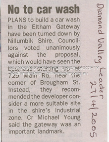
... Council rejected plan for 3 story building, 12 offices, ship, 8... Council rejected plan for 3 story building, 12 offices, ship, 8 ...Newspaper article: Diamond Valley Leader, 27 April 2005, No to car wash. Letter 25 July 2005 from Minter Ellison Lawyers attaching VCAT notice of adjournment. Letter 5 September 2005 re Application for review of Application for Review P1036/2005. Letter 6 September 2005 from Apex Building Design Studio to Minter Ellison Lawyers re carwash development. Newspaper article: Diamond Valley Leader 20 February 2007, Gateway 'blob' bid fails test, Nillumbik Council rejected plan for 3 story building, 12 offices, ship, 8 homes. Notice of Decision to Refuse to Grant a Permit, Application 191/2023/02P, Nillumbik Shire Council, 4 Oct 2023 Newspaper advertisement: Leader Associated Newspapers, Eltham Centenary Supplement, March 30, 1971, Mobil Service Centremain road, eltham, property, businesses, carwash, apex design studio, eltham gateway, minter ellison lawyers, mobil service centre (eltham) -
 Bendigo Historical Society Inc.
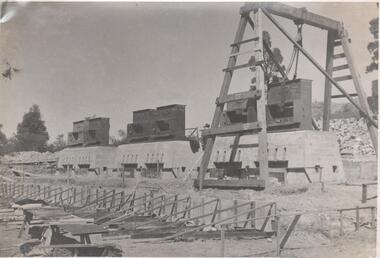
Photograph - Napoleon Reef Gold Mine Battery Site, 1936
The Napoleon (BML) gold mine (1932) was located near McDougall Road, Golden Gully, between Martin and Hattam Street. It had a depth of 921 feet. It was one of the latest and most lavish of Bendigo's mines. Plant and equipment were electrically driven. The four-compartment shaft, extra large by goldfield's standards, measured 17 feet 6 inches by 5 feet 2 inches and was cement lined below 900 feet instead of being red gum boxed as was the usual practice. The workshop was equipped to carry out all repairs for the equally lavish BML mines on the Nell Gwynne and Carshalton reefs. (The Gold Mines of Bendigo, Book 2, Arthur Victor Palmer) 'Napoleon BML Mines No Liability have issued a report for the fortnight ended September 5, where it states that the development scheme has been formulated and necessary equipment is being ordered. The Napoleon main shaft, (about 1700 feet south of the old Napoleon shaft) will be a four compartment shaft (17ft 6 inches by ft 2 inches inside the timber). aLevels will be opened at approximately 100 ft vertical intervals and cross-cuts extended approximately 125 ft each side of centre country to explore a cross-section across the anticline opposite to the shaft. At every fifth level, main drives will be extended north to connect with the old Napoleon shaft and south approximately 1800 ft. At the latter point, another cross-section of the anticline will be explored by rising and cross-cutting. The old Napoleon will be unwatered and on the 500ft and 1000 ft levels main drives will be driven to connect with main levels from the Napoleon main shaft to the south as well as being driven north 1800 ft where another cross-section of the anticline will be explored. Cross-sections further north and south may be developed as desired and also at intermediate points if necessary. Clearing and grading of the main shaft site are now in progress and the erection of the office and store building is proceeding. The design of engine room, change house and machine shops is now in hand and erection will proceed as soon as working plans and specifications are prepared.' The main shaft has been commenced at 3ft and advanced 10 ft. to 13 ft. https://trove.nla.gov.au/newspaper/article/10975478?searchTerm=napoleon%20bml (The Argus, 8th. September 1934, 'Mining' page 18) Significant to mining history of Bendigo.Black and white photograph of a stamper head being lowered into position on the battery site of the Napoleon Reef Gold Mine. A wooden gantry supports the battery head as it being lowered. Three large concrete foundations are visible in immediate background, two of which have stampers already in position, the third stamper is being lowered onto the final foundation. In immediate foreground, 'boxing' is erected for future concrete pours. napoleon gold mine, napoleon reef gold mine -
 Ballarat Tramway Museum
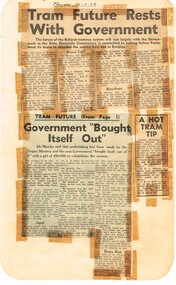
Newspaper, State Electricity Commission of Victoria (SEC) and The Courier Ballarat, Tram future rests with Government, Feb. 1962
Yields information about the views of various letter writers, views of the Courier, union views, rehabilitation costs Geelong, public meetings and meetings with SEC.Set of three Foolscap sheet of plain paper, with rounded corners, with newspaper cuttings, concerning the mooted closure of the Ballarat Tram system 20 Feb and 22 Feb 1962. All from The Courier, unless noted otherwise. 7940.1 1 - "Tram future rests with Government" - 22-2-62 - news report about the SEC being insistent on tabling the motion to close in Parliament, price of replacement trams. Attending Mr K L Murray, Mr Linaker, Mr A V Mawby of the SEC, Cr. A Pittard and Town Clerk Mr. H H Maddern. 2 - "Government "Bought itself out" - continuation from above, quoting Mr Mawby about the rehabilitation of the system in 1934 by the Government, discussions about fares, losses, time of travel from Sebastopol compared to buses. Also notes Cr Tuppen of Sebastopol. 3 - "A hot tram tip" - 22-2-62 - suggestion by Cr Cooper suggested the tram be retained around the lake for Historical reasons, Mr Murray of the SEC, sell/give to the Historical Society, Cr W E Roff replied about not wanting them and put them in a tip. 7940.2 1 - "SEC Not to sell this - 20-2-62 - photo of the power house in Ripon St, with the caption that the SEC did not propose to sell the property, but would be selling the tram depot site. 2 - "The talk was trams" - 22-2-62 - photo of Mr Mawby, Cr A D Mason, H Linaker and Mr K L Murray at the meeting with Council the previous day. 3 - "Save our Trams" - 21-2-62 - long letter - about the closing the trams and railway losses including building, new rail lines being built. 4 - "Tram fight" - letter by R Courtney Union Secretary, about the formation of a Committee to oppose closure. 7940.3 "Sound Shell Plan+ - 21-2-62 - Long editorial about the construction of a Sound Shell and council discussions and inability to make a decision.closure, letter to the editor, editorial, sec, rehabilitation, staff, buses, concession fares, museum, power station, ballarat a power station, botanical gardens -
Bialik College
Document (collection) - Papers of architect Ron Unger
redevelopment, buildings, construction, auburn rd, shakespeare grove, architecture, planningredevelopment, buildings, construction, auburn rd, shakespeare grove, architecture, planning -
Bialik College
Document (Sub-series) - Architect Ron Unger's papers relating to Auburn Road campus
development, construction, buildings, 1980sdevelopment, construction, buildings, 1980s -
Bialik College
Document (Sub-series) - Architect Ron Unger's papers relating to Shakespeare Grove
... to this record. construction buildings planning Document Architect Ron ...construction, buildings, planningconstruction, buildings, planning -
Bialik College
Document (Sub-series) - Documents relating to library redevelopment, 2009/2010
construction, buildings, 2000sconstruction, buildings, 2000s -
Bialik College
Mixed media (series) - Sites & Premises: fundraising appeals and plans for development
... buildings development planning shakespeare grove elc 1970s Mixed ...1990s, 2000s, 1980s, buildings, development, planning, shakespeare grove, elc, 1970s1990s, 2000s, 1980s, buildings, development, planning, shakespeare grove, elc, 1970s -
Bialik College
Documents, Construction of building on the Auburn Road campus, c. 1980s, 1980s
Plans for the construction of a building on the Auburn Road campus, c. 1980s. Please contact [email protected] to request access to this record.development