Showing 4068 items matching " surveys"
-
 Melbourne Tram Museum
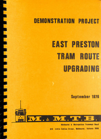
Document - Report, Melbourne & Metropolitan Tramways Board (MMTB), "Demonstration Project - East Preston Tram route upgrading Sept. 1976", Sep. 1976
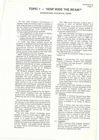
... Surveys ...Report - A4, 170 pages + card coves with plastic sheets black comb bound, titled "Demonstration Project - East Preston Tram route upgrading Sept. 1976" Has a Table of Contents, appendices, photograph, tables and diagrams. Looks at the delays on the East Preston route with methods of overcoming the bunching of trams, installation of kerbs for trams, traffic island, coordinated traffic lights along with Project costs. Notes it is a demonstration project.trams, tramways, mmtb, tramways, melbourne, surveys, passengers, east preston, traffic control, traffic lights, delays, road works, maps -
 Bayside Gallery - Bayside City Council Art & Heritage Collection
Map, Department of Crown Lands and Survey et al, Moorabbin, County of Bourke, Government Roads, 1920
The cadastral map of the Parish of Moorabbin in Victoria (L.6104) shows parish boundaries and land ownership 1920 when Sandringham was a Town. The government roads have been coloured in red pencil.moorabbin, county of bourke, map, plan, land subdivision, land titles, foreshores, hampton, beaumaris, highett, cheltenham, department of lands and survey, land owners, cartographic material, brighton, sandringham, town of sandringham, government roads -
 Kew Historical Society Inc
Archive (Sub-series) - Subject File, Kew Historical Society, Kew Association, 1974
Various partiesReference, Research, InformationSecondary valuesSubject file on ‘The Kew Association’ formed in 1974 as a separate group to the Kew Historical Society. Its constitution, which is filed, is general in nature. One part of the Association’s interests was the formation of a Historical Working Group to ‘examine historic buildings and other aspects of Kew’s history’. A founding member of the Society, Joy Stewart, was its convenor. By June 1974 it had 133 members. It differed from the Society in that it specifically aimed to improve Council services. One of its achievements was to begin a ‘historical home survey’ by street. The survey documents in the file list street name, number of house, side of street, size of house and general observations. Other information in the archive file includes correspondence, agendas, minutes etc. of the Association. As these only cover the years 1974-5, this may have been the period in which the group operated.kew - history, kew association - kew (vic), community groups - kew (vic), heritage - kew (vic)kew - history, kew association - kew (vic), community groups - kew (vic), heritage - kew (vic) -
 Bendigo Historical Society Inc.
Map - HUSTLER'S ROYAL RESERVE NO 2 CO. - LONGITUDINAL SECTION OF THE HUSTLER'S ROYAL RESERVE NO 2 CO
Longitudinal Section of the Hustler's Royal Reserve No 2 Co. on the Hustler's Line of Reef Bulletin No 33, Plate No VIII. Note - Plates 4, 8, 13, 20, 26 & 31 form a Longitudinal Section from Fortuna Hustler's to Hustler's Consols Mine. Mines mentioned are the Hustler's Royal Reserve No 2 Main Shaft, Hustler's Royal Reserve No 2 Park Shaft, Royal Hustler's, Imperial Hustler's, Great Extended Hustler's Freehold and the Great Extended. Section shows depth of levels, datum lines and height of sill above sea level yield in oz. of gold. Geological Survey of Victoria emblem. H. Herman, Director, W. Dickson, Secretary for Mines and The Hon. J. Drysdale Brown MLC, Minister for Mines and signed by H S Whitelaw, Underground Survey Office Bendigo, September 1913. mining, parish map, hustler's royal reserve no 2, royal hustler's, imperial hustler's, great extended hustler's freehold, great extended, geological survey of victoria, underground survey office bendigo, h s whitelaw, h herman, w dickson, the hon j drysdale brown -
 Bendigo Military Museum
Photograph - Army Survey Regiment Summer Ball – Officers and Guests Arrival, 1995
This is a set of 33 photographs taken at the combined Officer, Warrant Officer and Sergeant’s Mess Summer Ball held at the Army Survey Regiment (ASR), Fortuna Villa on the 25th of February, 1995. The Summer Ball was one of the last large scale formal functions held at Fortuna Villa before ASR’s closure the following year. Photos of personnel and their guests was taken on their arrival near the Pompeii Fountain in the gardens at the front of the main building. The Ball and Dinner was held at the rear of Fortuna Villa in temporary 20’ x 30’ Army tents set up on the roadway in front of the transport compound. SERCO contract staff provided the catering and the ASR’s Other Ranks performed stewarding and kitchen hand duties. Refer to item 6347 for information on the administrative file held in the collection and items 6370.23P, 6372.25P and 6373.36P for additional photographs taken at the Summer Ball.This is a set of 33 photographs taken at the Officer, Warrant Officer and Sergeant’s Summer Ball held at the Army Survey Regiment, Fortuna Villa on the 25th of February, 1995. The colour photographs are on 35mm negative film and are part of the Army Survey Regiment’s Collection. The photographs were scanned at 96 dpi. .1) - Photo, colour, 1995. Darren Radford and partner. .2) - Photo, colour, 1995. L to R: Craig Hersant and partner, Mrs & Mr Foster. .3) - Photo, colour, 1995. Stan and Maureen Vote. .4) - Photo, colour, 1995. Gordon (Muddle) Muir and partner. .5) - Photo, colour, 1995. John South and partner. .6) - Photo, colour, 1995. Bill and Jan Griggs. .7) - Photo, colour, 1995. John Bath and partner. .8) - Photo, colour, 1995. John Bath and Tara Bucknall. .9) - Photo, colour, 1995. Roger Grose and partner. .10) - Photo, colour, 1995. L to R: John Bath and partner, Roger Grose and partner. .11) - Photo, colour, 1995. Peter Crabbe and Jodi Cuskelly. .12) - Photo, colour, 1995. Marianne and Colin Cuskelly. .13) - Photo, colour, 1995. L to R: Peter Crabbe and Jodi Cuskelly, Marianne and Colin Cuskelly. .14) - Photo, colour, 1995. L to R: Maria and Tony Harder with daughter. .15) - Photo, colour, 1995. Brenton and Marg McDonald. .16) - Photo, colour, 1995, L to R: unidentified guests, Brenton McDonald and partner. .17) - Photo, colour, 1995. Frank Franceschini and partner. .18) - Photo, colour, 1995. Mick and Cathy Banham. .19) - Photo, colour, 1995. Ross Jenkins and partner. .20) - Photo, colour, 1995. L to R: Vik and Julia Sabaliauskas, Ross Jenkins and partner. .21) - Photo, colour, 1995. L to R: Noel and Jenny Coulthard. .22) - Photo, colour, 1995. A. Carrol-Keys (RACT) and partner. .23) - Photo, colour, 1995. Peter Cates and partner. .24) - Photo, colour, 1995. Terry and Sharon Lord. .25) - Photo, colour, 1995. Dave and Sue Stephenson. .26) - Photo, colour, 1995. Unidentified member and partner. .27) - Photo, colour, 1995. Simon Lemon and partner. .28) - Photo, colour, 1995. Glen Swiney and Don Swiney MBE. .29) & .30) - Photo, colour, 1995. Sandra and Duncan Burns. .31) - Photo, colour, 1995. L to R: Duncan and Sandra Burns, unidentified member and partner. .32) - Photo, colour, 1995. L to R: Unidentified member and partner, Matt Jackson and partner. .33) - Photo, colour, 1995. L to R: Glen Swiney, Simon Lemon, Dave Stephenson and partner, Simon Lemon’s partner, Andy Cordova (USA Exchange), Don Swiney MBE.1P to .33P There are no personnel or civilians identified.royal australian survey corps, rasvy, army survey regiment, army svy regt, fortuna, asr -
 Camperdown & District Historical Society
Photograph - Etching of early Camperdown scene, Mt Leura Camperdown, c1850s
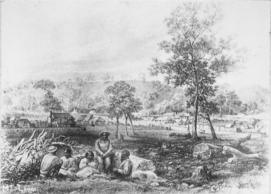
This etching was created of Camperdown c1850s showing a group of First Nations people and early dwellings and native vegetation around Mounts Leura and Sugarloaf. Camperdown was surveyed by Robert Dunbar Scott in 1851. First dwelling constructed by David Fenton in 1853 on site of Commercial Hotel. Etching of early Camperdown scene showing group of First Nations people in the foreground with early buildings, native vegetation and Mount Leura and Mount Sugarloaf in the background. On front: Mt Leura, Camperdowncdhs, djargurd wurrung, djargurdwurrung, mount leura, mt leura, mount sugarloaf, mt sugarloaf, cdhsfirstnations -
 Bendigo Military Museum
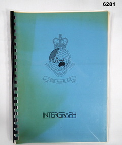
Administrative record - Intergraph Maintenance Programme for Project "Newhart", Intergraph, Suite 6, 1401 Burke Rd, Kew East 3102, 28 August 1992
Intergraph Maintenance by Replacement Proposal (MBR) is the Terms and conditions for the implementation of "Project Newhart" ad the ongoing maintenance of the Automap 2 System. The Document was prepared by Intergraph's Account Manager, Norman John McMurtrie and addressed to LtCol R McHenry, CO Army Survey Regiment.A4 Booklet, Plastic cover, Blue front cover and white rear, Plastic ring binder, RASvy Badge and Text "Intergraph". Pages inserted loose and not secured, includes diagrams and text.royal australian survey corps, rasvy, fortuna, army survey regiment, army svy regt, asr -
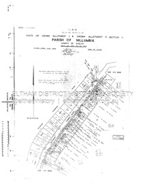 Eltham District Historical Society Inc
Document - Survey Plan, Country Roads Board, SP 6561, Eltham-Yarra Glen Road; Park Rd to Bellevue Rd, 1957
1957 C.R.B. Plan of Survey of Parts of Crown Allotment 1 & Crown Allotment F, Section II Parish of Nillumbik, County of Evelyn Eltham-Yarra Glen Road, Shire of Eltham Shows Surveyor field notes, property ownership and building type and construction.eltham-yarra glen road, country roads board, eltham, main road, survey plan, 1957, a.r. thomas, b. & b.d. hearn, b.g. anderson, bellevue road, e.m. pitts, f.a. m. macrae, g.e. & b. moulder, j. bromley, j.m. & s.g. johnstone, k.f. pitts, l.c. docksey, m. & e.c.w. baart, m.p. bromley, n.r. ord, p.j. & g.e. murphy, park road, r.a. bruce, r.a. macbeth, r.w. shearing, railway road, s.e. & y.p. houghton, w.k. bell, w.s.r. & f.n. toley, neil webster collection -
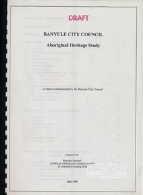 Eltham District Historical Society Inc
Book, Banyule City Council Aboriginal Heritage Study prepared by Austral Heritage Consultants, 1998 July
A draft report on the pre-European Aboriginal achaeological sites in the city of Banyule, including results of previous field surveys; Banyule covers a small part of the former lands of the Woi Wurrung. The report discusses heritage overlay, planning issues and the proposed Victorian planning provisions.100p, 30 cm.Marked "Draft"aboriginal heritage banyule, woi wurrung -
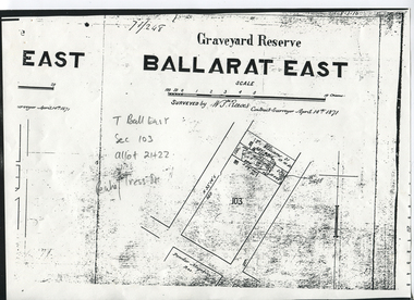 Ballarat Heritage Services
Digital photograph, Graveyard Reserve, Ballarat East
Ballarat East, Section 103, Allotment 21 & 22, Peake and Tress Streets, Mount Pleasant. Surveyed by W. S. Reeves Contract Surveyor April 14th, 1871. Also shows allotments of T. Williams and F. Macalpin, as well as the Powder Magazine Reserve.Plan of the Graveyard Reserve and Mount Pleasant Powder Magazine.mount pleasant, w.s. reeves, plan, powder magazine, t. williams, f. macalpin -
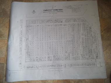 Rutherglen Historical Society
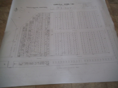
Carlyle Cemetery Map, Plan of Presbyterian Compartment, 1952
This is a map produced to attempt to bring order to the cemetery. Originally the layout was not well defined and it is difficult to use this plan to locate a particular grave, also the fact that not all graves are marked and foot paths are not defined has exacerbated this issue. Photocopy, White paper, black printing, black line work showing lot and compartment boundariesReferences Grid Survey points at 50 feet centres shown (as a cross with the reference mark number in brackets) Lot Number shown at left side of graves. Burial Number shown at right side of grave. Lots with unidentified burials show with dashed cross with in the lot. topographic survey, cadastral survey, carlyle cemetery, burials, graves, lot boundary, rotunda -
 Rutherglen Historical Society
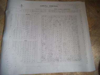
Carlyle Cemetery Map, Plan of Roman Catholic Compartment, 1952
This is a map produced to attempt to bring order to the cemetery. Originally the layout was not well defined and it is difficult to use this plan to locate a particular grave, also the fact that not all graves are marked and foot paths are not defined has exacerbated this issue. Photocopy, White paper, black printing, black line work showing lot and compartment boundariesReferences Grid Survey points at 50 feet centres shown (as a cross with the reference mark number in brackets) Lot Number shown at left side of graves. Burial Number shown at right side of grave. Lots with unidentified burials show with dashed cross with in the lot. topographic survey, cadastral survey, carlyle cemetery, burials, graves, lot boundary, rotunda -
 Rutherglen Historical Society
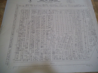
Carlyle Cemetery Map, Plan of Church of England Compartment, 1952
This is a map produced to attempt to bring order to the cemetery. Originally the layout was not well defined and it is difficult to use this plan to locate a particular grave, also the fact that not all graves are marked and foot paths are not defined has exacerbated this issue. Photocopy, White paper, black printing, black line work showing lot and compartment boundariesReferences Grid Survey points at 50 feet centres shown (as a cross with the reference mark number in brackets) Lot Number shown at left side of graves. Burial Number shown at right side of grave. Lots with unidentified burials show with dashed cross with in the lot. topographic survey, cadastral survey, carlyle cemetery, burials, graves, lot boundary, rotunda -
 Rutherglen Historical Society
Carlyle Cemetery Map, Plan of Wesleyan Compartment, 1952
This is a map produced to attempt to bring order to the cemetery. Originally the layout was not well defined and it is difficult to use this plan to locate a particular grave, also the fact that not all graves are marked and foot paths are not defined has exacerbated this issue. Photocopy, White paper, black printing, black line work showing lot and compartment boundariesReferences Grid Survey points at 50 feet centres shown (as a cross with the reference mark number in brackets) Lot Number shown at left side of graves. Burial Number shown at right side of grave. Lots with unidentified burials show with dashed cross with in the lot. topographic survey, cadastral survey, carlyle cemetery, burials, graves, lot boundary, rotunda -
 Melbourne Legacy
Document, Topic 1 - "How wide the beam?": Introductory statistical paper
1973 comprehensive statistical survey of likely numbers of Legatees, widows and children projected for 15 years, by W.K. Roberts, an Actuary at AMP, Melbourne. This was commissioned in order to consider the future of Legacy at a meeting in Hobart on March 24, 1973. The paper is identified as Appendix E, but the document it is appended to is missing. For the first time figures included the post 1945 conflicts, making the decline in child numbers more gradual, increasing the widow numbers more steeply, and predicting that Legatee numbers would be maintained until 1983 with the caveat that their capacity would change as they aged. Pinned to the printed survey is an anonymous handwritten note giving the number of children in residence at Harelands, Stanhope and Blamey House in 1972-4.Part of the history of Melbourne Legacy's involvement with residential care for children, indicating their awareness of the need to plan for the future.01666.1 White printed double sided sheets, black on white. 01666.2 Yellow copy paper with handwritten text in blue ink. residences, review, blamey house, harelands, stanhope -
Frankston RSL Sub Branch
Memorabilia - Level, Abney
Square gunsight telescope.An Abney level and clinometer, is an instrument used in surveying which consists of a fixed sighting tube, a movable spirit level that is connected to a pointing arm, and a protractor scale. An internal mirror allows the user to see the bubble in the level while sighting a distant target. It can be used as a hand-held instrument or mounted on a Jacob's staff for more precise measurement, and it is small enough to carry in a coat pocket -
 Bendigo Military Museum
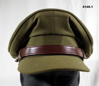
Headwear - CAPS, PEAKED, 1) EMERCO VIC (arrow up), Australian Army Peak Caps, 1) 1983. .2) 1990
.1) Peak hat, Kahki cotton twill, brown leather hand band with brass button keepers, size 55, lining is cotton fabric and clear plastic. .2) Peak hat, Kahki cotton twill, brown leather hat band with brass button keepers, corp badge Royal Australian Survey Corps, size 57, lining cotton fabric and clear plastic.headwear, peak caps, royal australian survey corps, rasvy -
Ringwood and District Historical Society
Map, Government Printer, Melbourne, Ringwood Zone Ordinance Survey Map, 1935
Ordinance survey map glued to cheesecloth, of Ringwood zone - Commonwealth topographical map dated 1.8.35, scale 1:63,360. Information correct up to June 1922. "Ringwood 81" printed on the reverse side.; Envelope and note from donor of item, with return letter of appreciation from Ringwood & District Historical Society dated 20-May-2005. +Additional Keywords: Reid, Don -
Bendigo Historical Society Inc.
Map - HEATHCOTE : COUNTY OF BENDIGO, May 1952
Map. Heathcote, County of Bendigo, County of Housie, Knowsley, Knowsley East, Langwornor, Tooborac, Warrowitue, Costerfield, Dargile, Township of Heathcote, Meadows Valley Creek, Wallan and Bendigo Railway, C.R.B. Main Road. By authority J.J. Gourley, Government Printer, Melbourne, Drawn and reproduced at the Department of Lands and Survey, Melbourne. May 1952, Price 2/-. (number 89 in map cupboard 1)J.J. Gourley, Government Printer, Melbourne.map, bendigo, heathcote -
Bendigo Historical Society Inc.
Map - MARONG : COUNTY OF BENDIGO, June 1953
Map. Marong, County of Bendigo, Nerring, Sandhurst, Lockwood, Shelbourne, Woodstock, Leichardt, Fletcher Creek, Bullock Creek, Township of Marong, Marong Railway Station, Bendigo Railway Line, Spring Creek, Crusoe Aqueduct. By authority W.M. Houston, Government Printer. Drawn and reproduced at the Department of Lands and Survey, Melbourne, Victoria. June 1953. Price 2/-. (number 73 in map cupboard 1)W.M. Houston, Government Printermap, bendigo, marong -
Bendigo Historical Society Inc.
Map - MAP WHITE HILL TO HUNTLY
Map of Bendigo creek and adjacent leads - White Hills to Huntly replotted from old 4 chain to 1 inch survey of 1860 by G. W. Hart - Surveyor. Base of roads and streets taken from D.L.S. 1 . 10000 base maps. Legend: battery site, puddling mill site, dam bank site, cutting altering course of creek, lead boundaries.bendigo, mining -
Bendigo Historical Society Inc.
Map - REDESDALE : COUNTY OF BENDIGO, 24-12-24
Map. Redesdale, County of Bendigo, County of Dalhousie, Kimbolton, Langwornor, Spring Plains, Glenhope, Emberton, Metcalfe, Hawkestone, County of Talbot, Campaspe River, Back Creek, River Coliban, Lyell. By authority H.J. Green, Government Printer, Melbourne. Photo-Lithographed at the Department of Lands and Survey, Melbourne by W.J. Butson, 24-12-24, Price 1/-. (number 120 in map cupboard 1)H.J. Green, Government Printer, Melbourne.map, bendigo, redesdale -
Bendigo Historical Society Inc.
Map - AXEDALE, COUNTIES OF BENDIGO & RODNEY, 8-2-26
Map, Axedale, Counties of Bendigo & Rodney, Wellsford, Strathfieldsaye, Eppalock, Knowsley, Weston, Muskerry, Ellesmere, Town of Axedale, Longlea Railway Station, Axedale Railway Station, Wallan & Bendigo Railway. Campaspe River.Axe Creek. By authority H.J.Green, Govt. Printer. Photo-Lithographed at the Dept. of Lands and Survey, Melbourneby W.J.Butson 8-2-26. Price 1/-. (number 60 in map cupboard 1)H.J.Green, Govt. Printer.map, bendigo, axedale -
Clunes Museum
Document - LAND LICENCE
.1 LICENCES FOR DEPARTMENT OF LANDS AND SURVEY - OCCUPATION BRANCH. LICENCE NO 315892 TO 315901. 25 FEBRUARY 1901 TO FEBRUARY 1902 STAPLED TOGETHER .2 LAND ACT 1869 SEC 20 BOOK 88. ON SPINE "THE CROWN - LAND ACT1869. SEC 20. 88 RECEIPTS FROM REVENUE OFFICE NO 2 TO 118 RECEIPTS 119 TO 249 HAVE NOT BEEN USED, THEY ARE CUT IN HALF.2 WHITE ROUND STICKER WITH "5" ON FRONTdepartment of lands and survey, land act 1869, occupation branch, revenue office -
 Villa Alba Museum
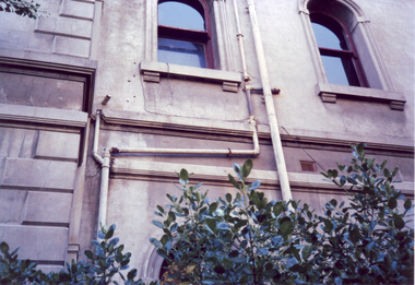
Photograph - Exterior pipe work, c.1987
Built for William and Anna-Maria Greenlaw in the early 1880s, and with interiors decorated by the Paterson Bros, Villa Alba remained in private ownership until 1949. From 1950, the house was owned by a number of institutions. By 1984, the Villa Alba Preservation Society had been formed, and three years later, the Mount Royal Hospital granted a 25-year lease to Kew Council. In 2004, the title to Villa Alba was passed by the Victorian Government to The Villa Alba Museum Incorporated. The Museum, at 44 Walmer Street, Kew, is now a cultural institution committed to the collection, study and display of 19th century interior decorative finishes, and the components of 19th and 20th century interior decoration.This is one of a number of historically and aesthetically significant photos of the interiors and exterior of Villa Alba when it was still owned by the Mount Royal Hospital, showing twentieth century accretions and deterioration of the historic fabric of the building. This was a benchmark survey against which future conservation and restoration activities can be measured.In December 1987, Mockridge Stahle & Mitchell Pty Ltd Architects prepared ‘Villa Alba Survey: A Report on the fabric for Mount Royal Hospital’ of which this photograph is a part. Photo of numerous pipes, all installed during the period when the house was owned by the Royal Women's Hospital as a home for nurses (1950-1974). The pipes extended from the roof and from rooms used as washrooms on the first floor.villa alba museum, conservation photographs, victorian architecture, drain pipes, waste water -
 Bayside Gallery - Bayside City Council Art & Heritage Collection
Map, Department of Lands and Survey, Land under the control of the City of Sandringham, 1962
The cadastral map showing land under the control of the City of Brighton in 1962.map, plan, foreshores, sndringham, hampton, beaumaris, cheltenham, department of lands and survey, cartographic material, moorabbin, black rock, street map, city of sandringham, board of lands and works -
 Ballarat Tramway Museum
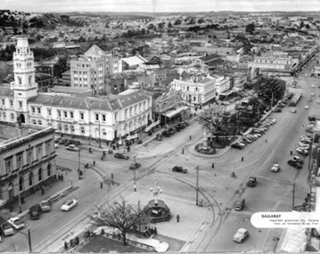
Photograph - Illustration/s, News and Information Bureau - Photo, Ballarat view from Town Hall, Oct. 1958
Yields information about the Sturt and Lydiard St streetscape from the Town Hall, c1958.Photograph of intersection of Sturt St and Lydiard St from Town Hall. Looking north east to Black Hill. See also item with Reg. No. 667 of similar but earlier view. Photo is inside cover of ANZ quarterly survey, dated Oct. 1958. Shows four trams in City Loop and good photo of trackwork and motor cars of period. Not to be displayed - before copy neg made.Ballarat - important Provincial Citytrams, tramways, sturt st, black hill, aerial views, trackwork -
 Melbourne Tram Museum
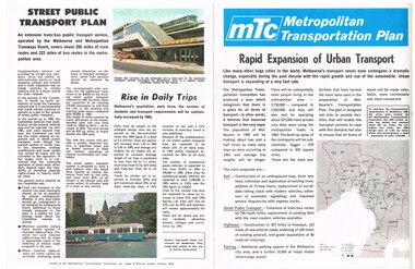
Pamphlet, The Metropolitan Transportation Committee, "Metropolitan Transportation Plan - Rapid Expansion of Urban Transport", c1968-69
Pamphlet full colour, four pages, printed on off white paper titled "Metropolitan Transportation Plan - Rapid Expansion of Urban Transport", issued by the Metropolitan Transportation Committee, c1968 - 69, explaining the planning of the Committee for Melbourne's transport in 1985. Looks at the future of Melbourne's rail, bus, tram and road network. Includes the survey and implementation. See Reg Item 623 for part of the final plan.trams, tramways, melbourne, road transport, tramways, railways, public transport, transportation plan -
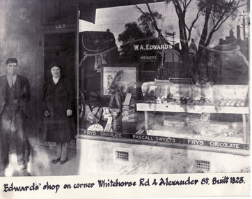 Whitehorse Historical Society Inc.
Photograph - Black and white photograph, Edwards Shop Mitcham, c1923
Black and white photo of Edwards Shop on cnr Whitehorse Road and Alexander Street, Mitcham. Built 1923. Mr. Edwards bought 5 acres running from Whitehorse Road to Victoria Street Mitcham in 1915 for 118 pounds. Alexander Street was surveyed in 1949 later. originally accommodating a mixed business and later the local Mitcham newspaper. It currently houses a take-away food shop.edwards, william alexander -
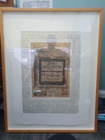 Glenelg Shire Council Cultural Collection
Mixed media - Framed Art Work, Wallace, Carmel et al, Lagoon, P1, Second - State, 2004
© Anna Lanyon , Carmel Wallace 2004. Apart from any fair dealing for the purposes of private study, research, criticism or review permitted under the Copyright Act, no text, image or part thereof may be reproduced, stored in a retrieval system, or transmitted in any form, without prior written permission from the authors.This suite of etchings explores the natural and social history of Fawthrop Lagoon, an ancient intertidal lagoon that lies at the heart of Portland on the far south-west coast of Victoria, Australia. The work records and interprets essential moments in the life of the lagoon, the plants, birds, insects, water-creatures and humans who have lived and continue to live around its shores. White card backing with white torn looking inner frame. Centre is a black printed overlay of a survey marker on top of a newspaper page taken from the Herald Sun on Tuesday February 3, 2004 with the weather forecast and the tides, moon, air quality, fish, world, beach report etc. Around the outside of the centre image is hand written wording in fine black ink.A/P 'Lagoon, P1, Second - State' Carmel Wallacefawthrop lagoon, portland, victoria, australia, plants, birds, insects, water, creatures, humans