Showing 4098 items
matching postcards - photographs
-
 Eltham District Historical Society Inc
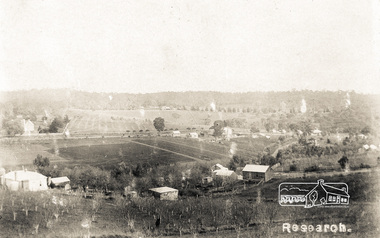
Photograph postcard, Research
... Photograph postcard... Aitken on loan to EDHS, 13 Feb 2018 Research Photograph postcard ...Road on right hand side is Smoodgers Retreat RoadDigital file only Postcards scanned from the collection of Michael Aitken on loan to EDHS, 13 Feb 2018michael aitken collection, postcards, research (vic.), main road -
 Eltham District Historical Society Inc
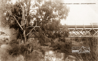
Photograph postcard, River Plenty Bridge, Greensborough
... Photograph postcard... Plenty Bridge, Greensborough Photograph postcard ...Postcard with view of bluestone bridge over the Plenty River on what is now Main Street, Greensborough. Built in 1860 by a Scottish stonemason, James Neave McKenzie. Most of the bridge was demolished in 1966 with the remaining bluestone arch preserved till 1983 when it was also demolished. This view about 1900.Digital file only Postcards scanned from the collection of Michael Aitken on loan to EDHS, 13 Feb 2018michael aitken collection, postcards, greensborough, plenty river bridge, plenty river -
 Eltham District Historical Society Inc
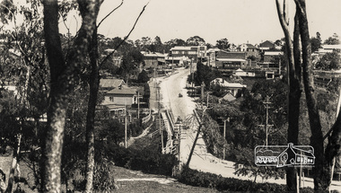
Photograph postcard, Main Road, Greensborough
... Photograph postcard... Feb 2018 Main Road, Greensborough Photograph postcard ...Postcard; W.M. Butterworth No. 3Digital file only Postcards scanned from the collection of Michael Aitken on loan to EDHS, 13 Feb 2018michael aitken collection, postcards, greensborough, main road -
 Eltham District Historical Society Inc
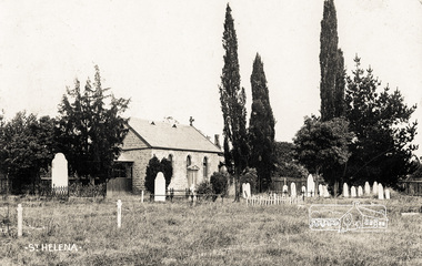
Photograph postcard, St. Helena church; postcard dated December 1907
... Photograph postcard...; postcard dated December 1907 Photograph postcard ...This is an early view of the historical church and precinct. Statement of Significance Last updated on - October 10, 2005 St Helena's is a rare surviving example of a churchyard cemetery. It is of local historical significance because of its association with the local pioneering family, the Beales, and other notable citizens including Walter Withers and Graham Webster. The cemetery is also the oldest in the municipality, of State significance. The high level of maintenance and the rural ambience contribute to the overall significance of the site. St Katherine's Church building has been reconstructed and is of local historical interest, principally for its value in interpreting the original setting within the Cemetery. It contains stained glass windows of local historical significance, commemorating casualties of the Beale family in World War One. - Victorian Heritage DatabaseDigital file only Postcards scanned from the collection of Michael Aitken on loan to EDHS, 13 Feb 2018michael aitken collection, postcards, st helena, st katherine's church -
 Eltham District Historical Society Inc
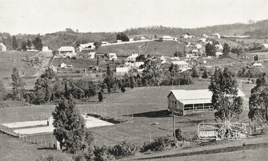
Photograph postcard, View at Diamond Creek, Vic., C. 1925-c.1930
... Photograph postcard..., Vic., C. 1925-c.1930 Photograph postcard ...Looking southwest from near the intersection of Clyde Street with Cowin Street (in vicinity of State School). St Anne's Church of England (with steeple) is on left side of Main Road. The Rose Series P. 4283Digital file only Postcards scanned from the collection of Michael Aitken on loan to EDHS, 13 Feb 2018michael aitken collection, postcards, diamond creek -
 Eltham District Historical Society Inc
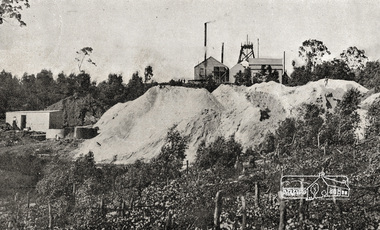
Photograph postcard, Diamond Creek Mine; postcard dated 1 March 1913
... Photograph postcard... Creek Mine; postcard dated 1 March 1913 Photograph postcard ...Digital file only Postcards scanned from the collection of Michael Aitken on loan to EDHS, 13 Feb 2018michael aitken collection, postcards, diamond creek, diamond creek mine -
 Eltham District Historical Society Inc
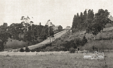
Photograph postcard, Entrance to Diamond Creek, c.1913
... Photograph postcard... to Diamond Creek, c.1913 Photograph postcard ...Digital file only Postcards scanned from the collection of Michael Aitken on loan to EDHS, 13 Feb 2018michael aitken collection, postcards, diamond creek, diamond creek mine -
 Eltham District Historical Society Inc
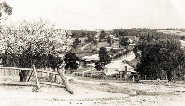
Photograph postcard, Diamond Creek Township, c.1913
... Photograph postcard....1913 Photograph postcard ...Digital file only Postcards scanned from the collection of Michael Aitken on loan to EDHS, 13 Feb 2018michael aitken collection, postcards, diamond creek -
 Eltham District Historical Society Inc
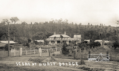
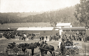
Photograph postcard, Scene at Hurst Bridge
... Photograph postcard... Photograph postcard ...Digital file only Postcards scanned from the collection of Michael Aitken on loan to EDHS, 13 Feb 2018michael aitken collection, postcards, hurstbridge, hurst bridge -
 Eltham District Historical Society Inc
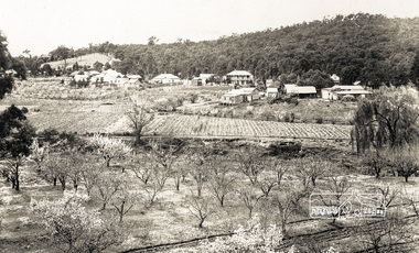
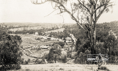
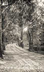
Photograph postcard, View at Hurstbridge, Vic.; postcard dated 28 October 1913
... Photograph postcard... at Hurstbridge, Vic.; postcard dated 28 October 1913 Photograph postcard ...The Rose Series P. 4095Digital file only Postcards scanned from the collection of Michael Aitken on loan to EDHS, 13 Feb 2018michael aitken collection, postcards, hurstbridge -
 Eltham District Historical Society Inc
Photograph postcard, View at Hurstbridge, Vic
... Photograph postcard... at Hurstbridge, Vic. Photograph postcard ...The Rose Series P. 4096Digital file only Postcards scanned from the collection of Michael Aitken on loan to EDHS, 13 Feb 2018michael aitken collection, postcards, hurstbridge -
 Eltham District Historical Society Inc
Photograph - Postcard, Rose Stereograph Company, View at Hurstbridge, Vic, c.1925
... at Hurstbridge, Vic. Photograph Postcard Rose Stereograph Company ...Rose Series Postcard P. 4341 “View at Hurstbridge, Vic.” Picnickers enjoying a Sunday outing near the Wattle Valley Estate at Hurstbridge. Copied from brochure "Wattle Valley Estate". It is believed the picture is taken at the northwest corner of the intersection of Wattletree Road and Hurstbridge-Arthurs Creek Road looking southeast towards the township (most likely where the house is located on the property of what is today No. 2 Wattletree Road)- https://goo.gl/maps/VDorwCe1rJJUapjE6 According to a comment by Jean Verso (via @nillumbikcouncil FB page 3 Jan 2020) - "This view is from Wattle Tree Road with Haleys Gully Road to the right and across the creek to William Gray's nursery at Allwood. The building to the far left looks like Dorset House. The building on the left in the middle distance is still there today and has been used for storage and as a stable/tack room for a number of years." The Wattle Valley Estate was first advertised in August 1925 as weekend building allotments by the Greater Melbourne Land and Development Company. Advertised from £28.10.0 or £60 per block. In August 1926, 30 picked allotments of 60x150 feet were put up for auction Saturday August 14, 1926 with frontages to Valley View Road and Fawkner Crescent advertised in the “Heart of the Glorious Wattle Country” and “Within 15 Minutes of the Newly Electrified Railway Station”. The Advertiser on August 13, 1926 in an article promoting the auction stated “the estate is regarded as one of the best in the district, and will be sold practically without reserve.” It is noted that an advertisement running in The Argus February 22, 1951 offered the remaining 16 blocks for sale at £12.10.0 or £200 the lot. By March 7, the remaining blocks were advertised at £17.10.0 The Wattle Valley Estate took over 20 years to sell and then people could not build on them Cross Ref SEPP_1057, “Popular Picnicing at Hurstbridge” rcopied from Wattle Valley estate sales brochure.Digital file only Postcards scanned from the collection of Michael Aitken on loan to EDHS, 13 Feb 20181925, dorset house, exhibition yprl 2019-12, fawkner crescent, haleys gully road, hurstbridge, hurstbridge-arthurs creek road, michael aitken collection, picnic, postcards, rose stereograph company, shire of eltham pioneers photograph collection, valley view road, wattle valley estate, wattletree road -
 Eltham District Historical Society Inc
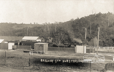
Photograph postcard, Railway Station, Hurstbridge
... Photograph postcard... Station, Hurstbridge Photograph postcard ...Digital file only Postcards scanned from the collection of Michael Aitken on loan to EDHS, 13 Feb 2018michael aitken collection, postcards, hurstbridge, hurstbridge railway station -
 Eltham District Historical Society Inc
Photograph postcard, View at Hurstbridge, Vic
... Photograph postcard.... Photograph postcard ...Digital file only Postcards scanned from the collection of Michael Aitken on loan to EDHS, 13 Feb 2018michael aitken collection, postcards, hurstbridge, bridge -
 Eltham District Historical Society Inc
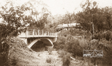
Photograph - Postcard, The Bridge, Hurstbridge, Vic
... . Photograph Postcard ...Arched Bridge (Monash Bridge) The Rose Series P. 4036 Reproduced in a brochure advertising the "Wattle Valley Estate" 7 minutes from the bridge. The new bridge designed by Sir John Monash over the Diamond Creek near Hurst's original home "Mia Mia" seen in the distance. The Wattle Valley Estate was first advertised in August 1925 as weekend building allotments by the Greater Melbourne Land and Development Company. Advertised from £28.10.0 or £60 per block. In August 1926, 30 picked allotments of 60x150 feet were put up for auction Saturday August 14, 1926 with frontages to Valley View Road and Fawkner Crescent advertised in the “Heart of the Glorious Wattle Country” and “Within 15 Minutes of the Newly Electrified Railway Station”. The Advertiser on August 13, 1926 in an article promoting the auction stated “the estate is regarded as one of the best in the district, and will be sold practically without reserve.” It is noted that an advertisement running in The Argus February 22, 1951 offered the remaining 16 blocks for sale at £12.10.0 or £200 the lot. By March 7, the remaining blocks were advertised at £17.10.0 The Wattle Valley Estate took over 20 years to sell and then people could not build on them.Digital file only Postcards scanned from the collection of Michael Aitken on loan to EDHS, 13 Feb 2018michael aitken collection, postcards, hurstbridge, monash bridge, bridge, diamond creek (creek), mia mia, shire of eltham pioneers photograph collection, wattle valley estate -
 Orbost & District Historical Society
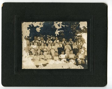
black and white photograph, Warren, Mrs H, C1900- 1910
This photograph was found in the Orbost Historical Society's cupboard. School is unknown. A copy of this photograph has been donated by Gil and Heather Richardson via the Mary Gilbert Collection. It is probably of students of Jarrahmond school where Miss Cope was the head teacher C 1916. This photograph could be associated with a celebration of Empire Day. The celebration of Queen Victoria's birthday on May 24 was renamed Empire Day in 1903 after her death in 1901. It was celebrated throughout the British Empire culminating in fireworks and bonfires in the evening. Empire Day was first introduced in 1905 to promote loyalty among the dominion countries of the British Empire. (from https://dictionaryofsydney.org/event/empire_day) Celebrated on 24 May, Queen Victoria's birthday, it was directed especially at school children. Teachers were encouraged to promote special steps to develop a feeling of pride in the British Empire and the achievements of the British race. Often a morning of short addresses, recitations and patriotic songs such as 'Rule Britannia' and 'Advance Australia' was followed by a half-day holiday to mark the celebration of Australia's strong ties to the British Empire. (from MuseumsVictoria) Some identified are; Top row -E- Eva Trewin; N-Rita Mundy; G-Elva Trewin; N- Jack Mundy D-Jack Trewin Middle row - Miss Cope, teacher. I Daisy or Katie McLeod Front row - L -Jack Stephenson; A Lindsay Trewin ; N-Frank Richardson Helena Warren was a self-taught photographer who became both the local press correspondent and a producer of humorous trompe l'oeil postcard images. The photographer, was a thirty-two year old settler living on a small mixed farm with her husband, William, at Newmerella, near Orbost in Gippsland, Victoria, when she bought her first camera, an Austral Box quarter-plate. Her family says she was entirely self-taught. Although not clearly dentified the photograph has significance in its association with Helen Frances Warren, a popular Orbost identity who was well known as an accomplished photographer and needleworker, It is associated with education in Orbost.A very old and damaged photograph of students an a teacher under a tree. The students are holding up cards that read "England, Ireland, Scotland". The photo is on a black card frame. a woman is standing on the left. Children are posed into three rows. There is also a copy of this photograph.photograph-helena-warren education-jarrahmond -
 Ringwood and District Historical Society
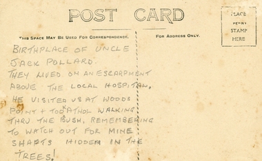
Photographs, Collection of Pollard Photographs, Ringwood (Undated -probably early 1900's). Also Woods Point 1900, circa 1900
... Pollard Photographs:; 1. Back of postcard of the Pollard... Road Ringwood North melbourne Pollard Photographs:; 1. Back ...Pollard Photographs:; 1. Back of postcard of the Pollard home in Wonga Road (also called Anderson Creek Road Road, and now Warrandyte Road).; 2. One bushel net apples, J Pollard, Victoria, Australia.; 3. Joseph and Emma Pollard and Family. Emma is nursing baby Ethyl.; 4. Ringwood PS photograph. Jack Pollard is second from the RHS in the back row.; 5. Woods Point with arrow indicating mine manager's house: that of Joseph Pollard. Circa 1900. The Pollard family had a 20 acre orcharding property between Mullum Mullum Road and Wonga Road. Given on 4th September 2010 by Arthur Lunt from his cousin. The Pollard family. School photo at Ringwood State School. Jack�s father was Joseph � land (orchard) between Mullum and Wonga Roads +Additional Keywords: Pollard -
 Ringwood and District Historical Society
Postcard, Photochrom Co. Ltd, Photochrom' fold-out lettercard of Ringwood, England c1930
'Photochrom' fold-out lettercard of Ringwood, England, from R.J.H. Futcher, Geelong. Contains 6 black and white photographs c.1930. -
 Ringwood and District Historical Society
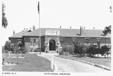
Photograph, Ringwood State School, Greenwood Ave. Built 1922 (Ward Series No 5 Postcard)
... 1922 (Ward Series No 5 Postcard) Photograph ...Typed below photograph, "Ringwood State School, Greenwood Ave. Built 1922" (although the date on the building reads 1921). -
 Ringwood and District Historical Society
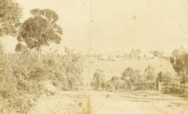
Photograph/Postcard, Warrandyte Road, Ringwood. Looking south towards central Ringwood. 1908. (Postcard + enlarged photos)
... Photograph/Postcard...) Photograph/Postcard ...Written on back of enlargement, "Warrandyte Rd. Looking south towards Ringwood.". Written on front "Railway Township Ringwood" On reverse of postcard: dated 4.12.1908, Addressed to Mrs L. H. Kenney, High St, Preston, Victoria. "Dear Sister, I hope you are all well. We are so but very just now. Love to all. L.K" -
 Ringwood and District Historical Society
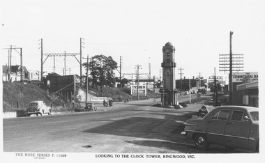
Postcard, Ringwood Main St and Clocktower in original position, Looking West.1956. Rose Series P.13869 Postcard
Printed below photograph, "The Rose Series P.13869. Looking to the clock tower, Ringwood, Vic.". Handwritten on Reverse 1956, -
Ringwood and District Historical Society
Postcards, Lee, Samuel & Co, Ringwood Views postcards incl Clocktower 1960s, 1960s
Used by people on holidays to send to friends or keep as mementos.10 coloured photographs of views around Ringwood with picture of clock tower on front.Ringwood, Vic. -
 Ringwood and District Historical Society
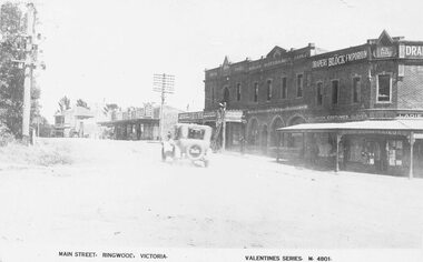
Photograph, Maroondah Highway Central, Ringwood. Main Street looking west. Adelaide St. corner on right. c1924
Photograph (3 copies- 2 large black and white, 1 sepia postcard) Typed below one of the photographs, "Maroondah Highway looking west. Shops to right now Eastland carpark. Shops in centre are opposite station entrance" Typed below other copy: "Main St. looking west. Adelaide St corner on right. c1924." Typed on sepia postcard copy: "Main Street, Ringwood, Victoria. Valentines Series. M4801." -
 Ringwood and District Historical Society
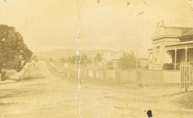
Photograph, Bedford Rd / Bayswater Rd. looking east from Warrandyte Rd. railway underpass, c1910
Dirt Road with houses and planter boxes for street trees on one side.Multiple copies of photos SS0078 and SS0079 - Backing sheet on one reads "Bedford Rd. looking east from Warrandyte Rd. railway underpass, c1910". Others have Bayswater Rd, Bedford Rd etc names. Some copies state "Ringwood House on Right". There is a also a postcard version. SS0079rev is an image of the postcard reverse, dated feb 24 1910 -
 Ringwood and District Historical Society
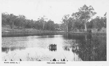
Photograph, The Lake, Ringwood. Ward Series No.1 Postcard (undated)
... Series No.1 Postcard (undated) Photograph ...1 image with postcard name, 1 with name cropped out.Inscription below photograph reads, "Ward Series No.1. The Lake, Ringwood". -
 Orbost & District Historical Society
black and white photographs, April 1916
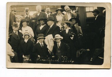
These photographs were taken at the official opening of the Orbost - Bairnsdale Railway Line. In 3150.3 which is of a group of children and two adults those identified in the photograph are ; L - R front row Mary Gilbert; Warren; Betty Gilbert; Marion Gilbert; Mrs Shaw and son; ? Gay; and Pen Gilbert. In 3150.4 L-R front " Mary Gilbert; Bet Gilbert (sitting with glasses); Pen Gilbert(Richardson); Marion Gilbert ( middle front little girl) About 1912 work began at Newmerella on clearing the track for the railway line from Bairnsdale to Orbost. A canvas town sprang up on the higher land adjacent to the river flats. Local farmers supplied meat, milk and fresh produce to the camp, as well as gaining employment carting and labouring. The line opened in 1916, the Orbost railway station being built on the Newmerella side of the river.This item is associated with the history of the Orbost-Bairnsdale railway line and therefore reflects the role that the rail line played in the social and economic history of Orbost. It is a pictorial record of a significant event in Orbost's history. On April 10 1916, the first scheduled train service left Orbost for Bairnsdale. The Bairnsdale-Orbost railway was opened to serve the agricultural and timber ndustry. Because of the decline in traffic and heavy operating costs, the line was finally closed in August, 1987. Four black / white postcards of people at the opening of The Orbost - Bairnsdale Railway. 3150.1 - on front - "The Ministerial Party" 3150.2 - on front - hand-written - " The Hon James Cameron" with arrow pointing to a man standing in the back row. at bottom - "The Ministerial Party X Florie Cameron" on back- "Opening the Orbost Railway" 3150.3 and 3150.4 - on back - hand-written "First train to Orbost with a list of names.orbost-bairnsdale-railway celebration-opening-of-railway east-gippsland-railway -
 Orbost & District Historical Society
black and white postcard, C1910
This an advertisement / souvenir for Merrangbaur House in Lakes Entrance. Merrangbaur was in , Lakes Entrance and stood on the on the Prince's Highway, about a kilometre from Lakes Entrance. It was destroyed by fire on the early morning of December 15, 1935. The original residence of the Roadknight family, the first white settlers in the Lakes Entrance district, Merrangbaur House had been conducted as a guest house for many years. Much of the furniture was lost, although a portion of the building, consisting of the ballroom and several bedrooms, was saved Mrs. Anne McInnes, aged more than 80 years, the mother of the proprietress, Miss McInnes, was the only guest sleeping in the house when the fire began and had to be assisted from her blazing bedroom on the ground floor. She was carried through a window by members of the fire brigade and spent the remainder of the night at the house of a friend. Miss McInnes was in Melbourne on a business visit arranging for Christmas bookings, when she was informed of her loss. (info. from The Argus Melbourne Monday December 16 1935)This item is associated with tourism in East Gippsland in the early 20th century.A black / white photograph / postcard.There is a photograph of a Lakes Entrance scene in each corner with a banner for "ROADKNIGHT'S MERRANGBAUR HOUSE' in the middle.In a circle is "FIRST CLASS ACCOMMODATION TARIFF 30/- WEEKLY". It has a note that "Coaches for Buchan Caves call at Merrangbaur daily".merrangbaur-lakes-entrance roadknight-lakes-entrance postcard-lakes-entrance -
 Orbost & District Historical Society
Postcard - post card, early 20th century
... and the photograph has been tinted. Postcard post card ...This postcard was produced as a black and white card titled, "Early 1900 - Bush Hut , Gippsland", in the early 20th century. The original card had a blank white rectangular strip on the right side of the photograph. This was for the message. There is little information with this item except for a note indicating that it was a hut at Newmerella. This is a pictorial record of a bark hut of the kind built by the early settlers of East Gippsland. Few early settlers could afford the time, or possessed the capital, to build any dwelling more impressive than a slab hut: Postcards form a vital part of social and historical records for researchers. A postcard showing a bearded man sitting on a stool outside a bark hut. There are various tools - a wheelbarrow and shovels, buckets, a panning dish and a saw hanging above him to the left. . It is in a bush setting and the photograph has been tinted.on back - POSTCARD - in red :"Essie & Ruby McKena. Emily Ville, Ascot Vale Road Flemington"dwelling-bush hut-bark -
 Orbost & District Historical Society
black and photograph / postcard, 1.4.1908
... black and photograph / postcard... and the banks are tree-covered. black and photograph / postcard ...This postcard was sent to Annie Gilbert (Mrs John Gilbert) of Tullagoota, Orbost. It was written by "Grace", probably her sister, Grace Cameron Annie Gilbert was the daughter of John Cameron who selected the first land on the Snowy River flats. This is a photograph of the original Orbost / Snowy River Bridge , a suspension bridge which opened in 1893. It has been taken when the Snowy River was in flood. It is similar to other photographs held in The State Library, Victoria. The Snowy River Mail and Tambo and Croajingolong Gazette Sat 12 Aug 1893 records the opening of this bridge as "the most important public event that has yet been commemorated in Eastern ......The Messrs McLeod, with whom the first settlement of this district is generally associated, took up their residence on the eastern bank of the Snowy River about the year 1841 or 42. The late Mr W. Roadknight and Mr T. T. Stirling took possession of the territory on the western side of the Snowy about 35 years ago. During the occupation of the country by cattle owners, very little progress was made in the way of roads and bridges, and except to the hardy and lexperienced bushman, it might have been generally regarded as inaccessible. About the year 1877, however, the late Mr James Robertson eldest son of Mr James Robertson, of Lochend farm, selected land now occupied by his father, about four miles from Orbost on the west bank of the river, Mr John Cameron visited the. district shortly after a .tour of inspection and returned later with his brothers, James and Alick Gameron, but found that during their absence Mr Ernest Watt had found his way on the scene and pegged out a selection, thus anticipating the advent of the Camerons by about 12 hours. We understand that a Mr Kidd, who selected the property now occupied by Mr W. J. Ross, at Pumpkin Point, was one of the earliest batch of settlers.........."This item is associated with Annie Gilbert (nee Cameron) reported to have been the first white girl to be born in Orbost. It is a pictorial record of the suspension bridge over the Snowy River which has since been replaced twice.A faded black / white postcard of a bridge across a river. There are cattle in the river and the banks are tree-covered.on back - a hand-written letter addressed to Mrs J. Gilbert Tullagoota Orbost.cameron-annie suspension-bridge-orbost snowy-river-orbost