Showing 110195 items matching "roads"
-
 Eltham District Historical Society Inc
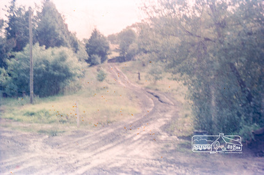
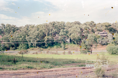
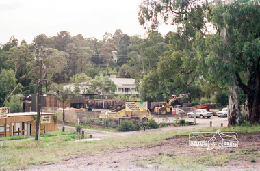
Photograph, Parsons Road, Eltham, c.1987
... roads ...Roll of 35mm colour negative film, 7 stripsKodak GA 100 5095roads, parsons road -
 Eltham District Historical Society Inc
Photograph, Parsons Road, Eltham, c.1987
... roads ...Roll of 35mm colour negative film, 7 stripsKodak GA 100 5095roads, parsons road -
 Eltham District Historical Society Inc
Photograph, Parsons Road, Eltham, c.1987
... roads ...Roll of 35mm colour negative film, 7 stripsKodak GA 100 5095roads, parsons road -
 Eltham District Historical Society Inc
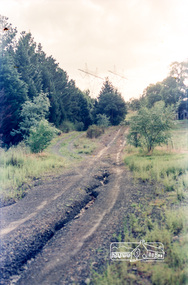
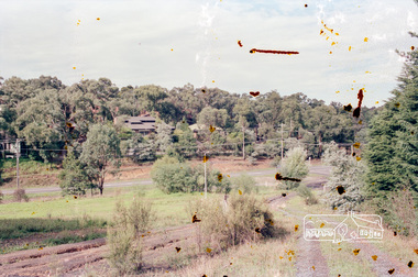
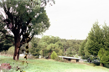
Photograph, Looking down Parsons Road to Main Road, Eltham, c.1987
... roads ...Roll of 35mm colour negative film, 7 stripsKodak GA 100 5095roads, parsons road -
 Eltham District Historical Society Inc
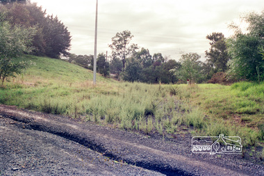
Photograph, Looking down Parsons Road to Main Road, Eltham, c.1987
... roads ...Roll of 35mm colour negative film, 7 stripsKodak GA 100 5095roads, parsons road -
 Eltham District Historical Society Inc
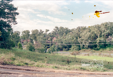
Photograph, Looking down Parsons Road to Main Road, Eltham, c.1987
... roads ...Roll of 35mm colour negative film, 7 stripsKodak GA 100 5095roads, parsons road -
 Eltham District Historical Society Inc
Photograph, Parsons Road, Eltham, c.1987
... roads ...Roll of 35mm colour negative film, 7 stripsKodak GA 100 5095roads, parsons road -
 Eltham District Historical Society Inc
Photograph, Parsons Road, Eltham, c.1987
... roads ...Roll of 35mm colour negative film, 7 stripsKodak GA 100 5095roads, parsons road -
 Eltham District Historical Society Inc
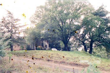
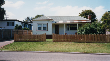
Photograph, Eltham Garden Supplies, 1431 Main Road, Eltham, c.1987
... roads ...Now Webster Farm and GardenRoll of 35mm colour negative film, 7 stripsKodak GA 100 5095roads, main road -
 Eltham District Historical Society Inc
Photograph, Parsons Road, Eltham, c.1987
... roads ...Roll of 35mm colour negative film, 7 stripsKodak GA 100 5095roads, parsons road -
 University of Melbourne, Burnley Campus Archives
Plan - Sketch, Widening road for parking. Buildings in College area occupied by other branches, c. 1950
... roads ...Sketch plan.burnley school of horticulture, roads -
 Ringwood and District Historical Society
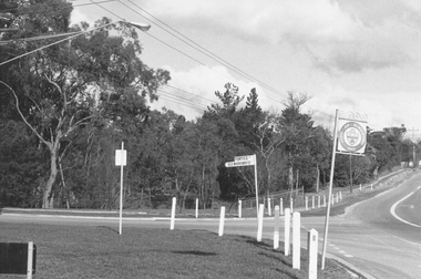
Photograph, Intersection of Tortice Dr. Old Warrandyte Road and Warrandyte Road 1981
Written on back of photograph, "19/6/81. Intersection of Tortice Dr. Old Warrandyte Road and Warrandyte Road (on right)." -
 Ringwood and District Historical Society
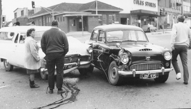
Photograph, 2 car Accident in front of Ringwood Post Office, cnr Whitehorse Rd and Ringwood St circa 1960s
Catalogue card reads, "Accident on Whitehorse Road. Old Ringwood Post Office on corner of Ringwood St. and Whitehorse Road." -
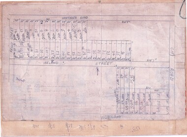 Ringwood and District Historical Society
Document, Subdivision Map (Undated) - Ringwood, Victoria
Hand-drawn copy of subdivision plan showing numbered residential allotments with property dimensions.Map includes Wantirna Road, Ireland Street, City Road and Victoria Street (later Regina Street), Ringwood, Victoria. -
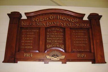 Coal Creek Community Park & Museum
Honour Roll, Kilcunda Road School Honor Roll
This WWI Honor Roll was originally displayed in the Kilcunda Road State School (no.3337), which was located at the north east corner of the intersection of the Bena - Kongwak and Buchanans' Roads, Bena, Victoria, 3946. The school was located amongst the cypress trees at 645 Bena-Kongwak Road. The school was relocated in 2008 to the Coal Creek Community Park and Museum, 12 Silkstone Road, Korumburra, 3950 to become the Masonic Lodge building in the park display. On the west side of the intersection of the Bena - Kongwak and Buchanans' Roads is a brass plaque on a granite boulder with the following inscription TO COMMEMORATE THE DISTRICT OF KILCUNDA ROAD First Surveyed 1879. This is the site of the KILCUNDA ROAD UNITING CHURCH 1911 to 1966. Diagonally opposite at 645 Bena-Kongwak Road was the site of the KILCUNDA ROAD PRIMARY SCHOOL No: 3337, 1902 to 1975. Erected by The School Mother’s Club continuing as The Kilcunda Road Social Club 2008. One of the few remaining historic items from Kilcunda Road settlement.Honour roll of varnished wood, with three panels, an undulating shaped pediment, plain columns at sides, painted gold text and the Australian Imperial Forces insignia on base.Roll of Honor, Kilcunda Road State School. In Honor of Old Scholars of this school who served the Empire in the Great War, 1914-1919, Australian Imperial Force. (X) These made the supreme sacrifice. Sister J.E. Turner , E.N. Barge, E.F. Binding (X), E.H. Bunn, D. James (X), W.James, A. James (X), R. H. James, A.G. Rose (X), C.W. Stanlake, G. Wuchatsch, R. Wuchatsch, T.E. Young kilcunda road, honour roll, state school no.3337., wwi -
 City of Kingston
Pamphlet - Colour, H. R. Hill & Co, Walker's Estate, Cheltenham for sale by public auction, c. 1923
Sales plan for land in the suburb of Cheltenham, encompassing both sides of Walker Grove, a section of Centre Dandenong Rd and Axelton St. The developing urban area of Cheltenham within the City of Kingston. This land sale pamphlet illustrates the subdivision of land within the municipality and the changing demographic of the district as new houses are constructed.Black and white pamphlet advertising for private sale the Station Entrance Estate, Highett. Incorporates a map of the estate bordered by Wickham Road, Railway Parade, Highett Road and Point Nepean Road.Handwritten in black pen on subdivision map: 'x' written on subdivisions 2, 3, 8-11, 15-17, 19. Potentially indicating that these properties did not sell at auction. Handwritten in black pen on subdivision map: assumed sale price on subdivisions 1, 4-7, 12-14, 18, 20-31. land sales, cheltenham, estate -
Canterbury History Group
Photograph - Exposed side door of shop No. 80 Maling Road, Jan Pigot, 27/03/1993 12:00:00 AM
Coloured photograph of the exposed side door of shop No. 80 Maling Road due to the demolition of the Maling Road Theatre. Sign showing the land for lease and a profile of shop No. 80 Maling Roadcanterbury, maling road, shops -
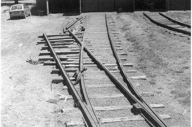 Ballarat Tramway Museum
Photograph - Black & White Photograph/s, Dave Macartney, 8/02/1985 12:00:00 AM
Has a strong association with the completion of the track fan at the BTPS depot during 1985 and yields information about the method of construction.Black and White photograph of the construction of No. 7 road at the BTPS Depot, 8/2/1985. shows the points installed and some rail laid out pending bending. Photographed by Dave MacartneyOn rear in ink "No. 7 road takes shape. Within three weeks, the track was complete to the back wall of the shed, lifted and packed in use. Label "Photo Page 34 top Reduce to 5 1/2" x 2 7/8". and in bottom left hand corner "Photo Dave Macartney" See April 1985 Trolley Wiretramways, trams, btps, trackwork, track laying -
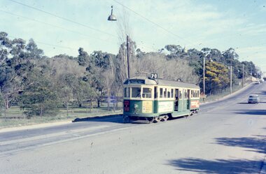 Melbourne Tram Museum
Photograph - Four colour slides - Wattle Park Single Line, Warren Doubleday, 1-8-1970
Set of four photographs taken at the time of the conversion of the Wattle Park route, in Riversdale Road from single line to double track between Warragul Road and the terminus, alongside Wattle Park itself. Yields information on the single line operation of the Wattle Park line prior the conversion to double track operation.Set of four colour Anscochrome slides, of single line operations on the Wattle Park line. .1 - W5 722 on Wattle Park single line, Sat. p.m. .2 - W2 388 meets W2 344 on Wattle park loop - shows the commencement of roadworks. .3 - SW5 853 from the park .4 - W5 738 at Warragul Road - shows the gates to Wattle park and the Caltex Service Station sign.Has photographers slide numbers on each slide.wattle park, route 70, riversdale rd, w2 class, w5 class, sw5 class, trackwork, tram 722, tram 388, tram 853, tram 738, trams, tramways -
 Kew Historical Society Inc
Photograph - Kew Main Drain, 1984
'Kew, Kew East, Balwyn & Balwyn North are located approximately 7km north east of Melbourne. Four main stormwater drains service the area flowing from south to north. Three of the drains: Deepdene Drain; Balwyn Drain & Glass Creek converge in Kew East just west of Burke Road at Kew High School before discharging into the Yarra River. The fourth drain, Kew Main Drain connects directly with the Yarra River to the West of Glass Creek.' The Kew Main Drain is a barrel drain that was created in the 1930s, and follows the route of the former Connor's Creek from the vicinity of Genazzano FCJ College to the Yarra River in East KewImportant and verifiable evidence of the construction methods used by the Melbourne & Metropolitan Board of Works in building the Kew Main Drain, before its reconstruction in c.1985.Original print colour positive photograph of the Kew Main Drain, provided on 14/12.84 to the Chief Engineer of the City of Kew, Ian Poulter, by the Supervising Engineer (Works), Southern and Eastern Drainage, Melbourne & Metropolitan Board of Works. The record includes an image of the reverse as well as the donation document from the MMBW."A84/1855-10 / 750mm council drain looking U/S [up stream] from Parkhill Road, Kew."kew main drain, stormwater drains -- kew (vic.), connor's creek -- kew (vic.) -
 Ringwood and District Historical Society
Article - Newspaper Clipping, Land Sale Advertisements, Golden Hill Estate, Ringwood - 1965, 1966, and Plan of Survey of Lot 8, Mullum Mullum Road Ringwood, 1970
Newspaper clippings from Melbourne Sun newspaper (11th December 1965 and 15th January 1966) advertising sale of land - Golden Hill Estate, Ringwood, with summary of features and aerial photograph including artistic representation of street layout. Subdivision includes Mullum Mullum Road, Sonia Street, Jill Court, Linda Drive, Eve Court, Alma Court, and Jacynthe Court. Attachments include reference to Lot 46 as site of original Peter Vergers' orchard residence and subsequent 1970 surveyor's Plan of Survey of Lot 8 Mullum Mullum Road Ringwood, LP 67513, Cert of Title 8581/429.Agent - Aaron, King & Co., Suite 2, 33 Queens Road, Melbourne. (Phone) 26-2443, A.H. 850-2195. Plan of Survey signed on 25.7.1970 by Roger M. Gamble, Land Surveyor, 28 Summit Crescent, Ringwood 3134. -
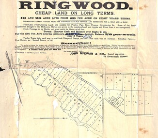 Ringwood and District Historical Society
Flyer, Land Sale Advertisement, Ringwood, Victoria - 1894
Land sale advertisement for 10 and 20 acre lots from £5 per acre on eight years' terms in Ringwood, with description of local facilities and agricultural features.Subdivision map includes Mullum Mullum Road, Wonga Road, Oban Road and Anderson's Creek Road (later Warrandyte Road). Markings on reverse side indicate the sheet was sent by post from John McEwan & Co., Auctioneers, Land Agents & Business Brokers, 71 Swanston Street, Melbourne, to Mr Allan, Builder, Ringwood, postmarked in JE (June), 1894. -
 Mt Dandenong & District Historical Society Inc.
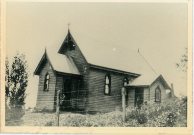
Photograph, Church of England, Olinda
Church of England. Monash Avenue, Olinda. The descriptive text on the reverse of this photograph was hand written by John Lundy-Clarke.Church of England Olinda When the church was built it faced on to the main Mt Dandenong Road but the road was deviated in and the main road section in front of the Village Settlement blocks was named Monash Avenue. The chapel built on Mrs Warner’s land on Mernda Road (later Coonara Road) was shifted in 1936 by Dick Mitlan using Jack Clarkes Ford truck as traction plant. church of england, olinda, monash avenue -
 Surrey Hills Historical Society Collection
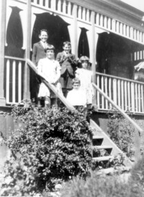
Photograph, McPhie children, of 5 Suffolk Road, Surrey Hills
5 Suffolk Road was the Mounted Police Station from 1889 - 1914.Image of a five young (school age or younger) children (three boys, two girls) standing on the exterior steps of a building identified as the Mounted Police Station, 5 Suffolk Road, Surrey Hills. The children are identified as the family of Sgt. David McPhie. The children are dressed in 'best clothes.' The main part of the building is not visible however it does have a decorative wooden verandah.people, families, family groups, children, girls, boys, police, policemen, surrey hills mounted police station, structures and establishments, police stations, david mcphie -
 Bayside Gallery - Bayside City Council Art & Heritage Collection
Map, H.B. Foot, Plan of the Brighton Estate containing 5120 acres, first special survey at Port Phillip, c. 1842
This plan records the Brighton Estate, also known as Dendy's Special Survey. In 1840 Henry Dendy, a farmer in Surrey, England acquired a "Special Survey" from the Commissioners for Land and Emigration which gave him the right to choose land in Port Phillip for the low price of £1 per acre for 5120 acres. Dendy appointed Jonathan Binns Were, as his agent, who later became a partner. Together, Dendy and Were decided on an area 5 miles south from Melbourne, bounded by North Road, East Boundary Road, South Road and to the west by Port Phillip Bay. Their Brighton Estate was first surveyed by T. S. Townsend in May 1841 and was re-surveyed by Robert Hoddle. Dendy and Were were making plans to sell the land and advertised a 30-guinea prize for the best subdivision which was to be divided into a village, marine residences, suburban and cultivation allotments, with the remainder being divided into country sections. The competition was won by H.B. Foot, who planned the village around a reserve and crescents and a 'green belt' forming the town boundary. brighton estate, dendy's special survey, special survey, henry dendy, jonathan binns were, w.b. were, survey, plan, map, brighton, george ward cole, baker's lithographer, hibernian, subdivision, town planning, cartographic material, h.b. foot -
 Whitehorse Historical Society Inc.
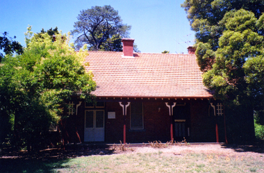
Photograph - Coloured photograph, Matheson's Home Forest Hill
The Nunawading orchard was purchased in 1920 by Mary Lilian Matheson from Florence Rebecca Course for a sum of 1050 Sterling Pound. In 1988 the Federal & State government allocated $125,000 to the Nunawading Council towards the purchase of the house, outbuildings and the orchard facing Springvale Road, as it was representative of one of the last working orchards in the Nunawading district. The property has now been vacant for many years (2011) and is secured with window bars and security services. Lately a large cyprus tree crashed onto the largest outbuilding and it was removed.8 coloured photographs (a-h) of the Matheson house and orchard on Springvale Road, East Burwood. House, shed, windmill, old orchard and pine and cyprus in the photographs.matheson, mary, matheson orchard, orchards, early burwood, strathdon -
 Lakes Entrance Historical Society
Photograph - Historic House, 2000
Part of a larger dwelling originally situated 607 Esplanade, (now site of Golden Beach Motel), other half moved to Lake Tyers Beach Road. This section moved to present site around 1965 by Ray Curry. Various residents Misses Phillips (original site) George Ward, R A and K D Bills from 1993.Colour photograph of a weatherboard dwelling with hip roof situated at 15 Coates Road. Has a bull nose veranda across front entry, oiled timber picket fence. Lakes Entrance Victoriahouses, fences, heritage study -
 Wangaratta RSL Sub Branch
Mixed media - Framed Map and Newspaper, Peter Muncey, 23/7/1943
Sketch Map of Bulldog-Wau Road New Guinea drawn to scale by 2/1 Aust Fd Coy dated 23.7.43 and signed by soldiers together with related newspaper article. Hand sketched by Peter Muncey VX10042 a Draughtsman who served in the Middle East Ceylon and New Guinea with the 2/2 and 2/1 Field Coy Royal Australian Engineers. The sketch contains 26 signatures including:- S/Sgt Raymond Hector Ibbotson NX14112 who served in the Middle East and New Guinea Lt Col Jack Graham Wilson NX 130646Bulldog Track also known as Bulldog-Wau road was longer, higher, steeper, wetter, colder and rougher than Kokoda Track. In 1943 Australian Army engineers; the 2/1 and 2/16 Field Company RAE, 9th Australian Field Company (AIF), veterans of Syria, Palestine, Egypt, Greece and Crete, the 1st and 3rd Australian Pack Transport Companies and local Papuan labour cut the road with pickaxes and dynamite over a period of eight months. During five months of operations over seventy per cent of the 2/1 Australian Field Company contracted malaria.Seventeen bridges were constructed; mostly single, but at least one with multiple spans. More than two thousand Australian army personnel and over two thousand Papuans and New Guineans were involved during nine months of construction. Thus the road, acclaimed as the greatest military engineering feat ever, was completed and for the only time in history motor vehicles crossed the high rugged mountains of Papua New Guinea. Carved brown timber frame with cream mount containing hand sketched map with soldiers signatures and two newspaper articles.Sketch Map of Bulldog-Wau Road 23.7.43 2/1 Aust Fd Coy Newspaper - Diggers pushed on with pick and shovelbulldog-wau road, map, new guinea, ww2, 2/1 aust field coy -
Whitehorse Historical Society Inc.
Article, Inspired to write, 2001
Article on four women from Whitehorse who will share their life stories in an exhibition at the Museum of Victoria.Article on four women from Whitehorse who will share their life stories in an exhibition at the Museum of Victoria, Valda Arrowsmith, former Nunawading Mayor, Mary Ryan, former Box Hill mayor, Helen Trotter, Carrington Road Seniors Club advocate and Councillor Kaele Way.Article on four women from Whitehorse who will share their life stories in an exhibition at the Museum of Victoria. women, community services, arrowsmith, valda, ryan, mary, trotter, helen, way, kaele -
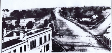 St Kilda Historical Society
Photograph, St Kilda Junction with Old Police Paddock, c. 1858
on back: St Kilda Junction showing old police paddock and canoe tree? Date unknown, but before bitumen surfacing of roads -- pre 1900? Copy courtesy LaTrobe Library, Melbourne Handwritten: about 1858copy of(?) black and white photograph fair condition unmountedSt Kilda Junction showing old police paddock and canoe tree? Date unknown, but before bitumen surfacing of roads -- pre 1900? Copy courtesy LaTrobe Library, Melbourne Handwritten: about 1858