Showing 179143 items
matching streets
-
 Melton City Libraries
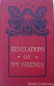
Book, 'Revelations of my friends', 1914
Rosemary Myers spoke about Lizzie Daley in May 2012. She described the house as having lots of ornaments, and how she enjoyed going thereto buy ribbons and laces for a pair of baby booties she knitted for her school handwork at Melton P S 430. Margaret Nolan's memories of Lizzie: When we were young kids we would go down to visit our cousins, the Myers who lived on the Highway. My great grand mother Mary Luby lived in Reserve road when she came to Melton, she was married here in 1857. Her sister Ann nee Dowling was married to Henri Miers [Myers] in 1867. Her other sister Eliza married William Daley in 1862. He had a Bootmakers shop in the High street. Their daughter Lizzie later turned it into a haberdashery shop. We would go there to buy sewing threads and ribbons. Margaret nee Nolan Brooks memories recorded on the 20th September 2013 Book was from Lizzie Daley's shop in High Street, Meltonlocal identities -
 Ballarat Heritage Services
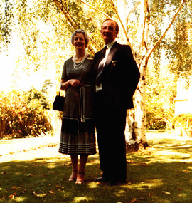
Photograph - digital copy, Jack and Kathllen Gervasoni Mayor and Mayoress of Kew 1979-80 at Chellowdene, 1979
Chellowdene was an architect designed triple fronted 1950s brick dwelling with an Edna Walling garden at 37 Wills Street, Kew. It was demolished by the subsequent owner.Copy of a colour photograph showing City of Kew Mayor John H. Gervasoni and Mayoress Kathleen Gervasoni in the front of their Kew property 'Chellowdene', 37 Wills Street, Kew. mayor, mayoral, portrait, kew, gervasoni, john, jack, k, mayoress, chellowdene, wills, kew mayors, wills street kew -
 Port Melbourne Historical & Preservation Society
Photograph - Nott Street State School Photograph, 1945
Class at Nott Street State School in 1945. The back has an attached label naming the pupils. Top Row L/R ?, A. CAMPBELL, J WATERSON, J ALLARD, A STOCKTON, D CLARK, D CLARK, W MURRAY, 2nd Row L/R ?, S GAY, C ERMEL, B JAMES, B CHRIMES, A EASTON, ? , W WHITE. 3rd Row L/R ?, J ELMSON, ? , J SAW, H DOWNER, ? , ? , B MORGAN, ?. 4th Row L/R ? , B KENT, F TAYLOR, ? , O MARSH, ? JENKINS, B MILLER, ? , H JACKSON. 5th Row L/R F POWER, G BENNET, F NICHOLSON, ? , B CAMPBELL, ?. Sepia photograph of 5 rows of children at Nott Street State School in 19451945 Nott Str No1427nott street state school, a. campbell, j waterson, j allard, a stockton, d clark, w murray, s gay, c ermel, b james, b chrimes, a easton, w white, j elmson, j saw, h downer, b morgan, b kent, f taylor, o marsh, ? jenkins, b miller, h jackson, f power, f nicholson, g bennet, b campbell -
 Warrnambool and District Historical Society Inc.
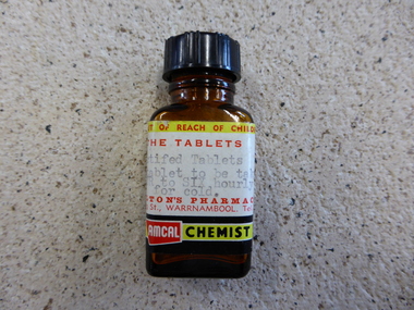
Bottle, 1960s
This bottle has been issued to a customer of Shilton's Pharmacy 11 9 Liebig Street, Warrnambool. The bottle contained tablets to be taken for a cold. Harry Shilton bought the business in 1937 and added a chiropody clinic and a hairdressing salon and he was known as the " Man in White.' . In 1953 Harry Shilton took on a partner Alan Anderson . Harry Shilton retired in 1960 and Alan Anderson continued as the proprietor, transferring the partnership to John Lindsay in 1967. The name Shilton was still used until 1972. This bottle is of minor importance as an example of tablets in a bottle as used by customers in the 1960s.A brown glass bottle with a plastic lid. It has a label with red and black printing. The base of the bottle has embedded in it letters and numbers AMCAL CHEMIST SHILTON'S PHARMACY 119 LIEBIG STREET WARRNAMBOOL TEL 2006 M 1017 -
Lakes Entrance Regional Historical Society (operating as Lakes Entrance History Centre & Museum)
Photograph, Lakes Post Newspaper, 1/01/1992 12:00:00 AM
Also two other black and white photographs of Rodney Streeter taken at the Art Show January 1992 and January 1993 numbers 04070.1 and 04070.2 sizes 13.5 x 7.5 cm and 8 x 11 cmBlack and white photograph of chain saw artist Rodney Streeter at Rotary Art Show held at the Old Mechanics Hall Lakes Entrance Victoriasports -
 Stawell Historical Society Inc
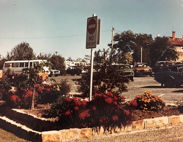
Photograph, Car Park in Sloane Street looking towards Main Street Stawell c 1978 - Large coloured photograph
Colour photograph of Car Park Sloane Street looking towards Main Street Stawell. The car park was created when Main St. Stawell became a Pedestrian Mall c 1978Large coloured photograph taken from Sloane Street, looking towards Main St. The photo has a bus on the left hand side and cars in the car park. The photo is taken in front of a garden bed with a No Entry sign in the middle of the photograph.stawell -
Lakes Entrance Regional Historical Society (operating as Lakes Entrance History Centre & Museum)
Photograph, 1970 c
Also a second black and white photograph of members of a Youth Group on back of Hancocks truck during street procession Lakes Entrance 05064.1 15 x 20 cmBlack and white photograph of members of Lakes Entrance Football club in fancy dress on tray of one of Hancocks trucks during a street procession in Lakes Entrance Victoriatransport, fishing industry -
 Old Colonists' Association of Ballarat Inc.
Photograph - Photograph - Colour, Ballarat Old Colonists' Association Homes, Charles Anderson Grove, Ballarat
HISTORY OF THE BALLARAT OLD COLONISTS' ASSOCIATION HOMES AT CHARLES ANDERSON GROVE, LAKE GARDENS One of the original objectives of the Association was “to provide the shelter of a house for those Pioneers of the Goldfields whom the reverses of fortune have deprived of the means of procuring the comforts of life in their declining years.” While the first home at Charles Anderson Grove was built in 1925 the Association had previously provided relief for needy pioneers from the time it was formed in 1883. Relief included monthly monetary payments, loads of firewood, medical assistance and distribution of Christmas boxes of groceries to deserving pensioners and in some cases payment of burial costs. Records indicate that in September 1922 three of the pensioners being assisted by the Association were accepted as residents in the newly erected Hassell Homes in Gillies Street (now demolished-opposite the High School). The first site for an Asylum for Indigent Members of the Old Colonists' Association was temporarily reserved from sale in October 1891. The site was approximately 28 acres in area in Mt Clear nearly opposite Midvale Shopping Centre in Main Road. The site was heavily timbered and when cleared over 260 tons of wood was sold to the Woah Hawp Gold Mining Company. A set of gates were erected but no homes built, although a plan for this reserve was drawn which showed twenty buildings ranging from one to four unit per building. The reserve was revoked in November 1909. The second site temporarily reserved in November 1909 as an Asylum was in Alfredton and consisted of some 7 acres and was adjacent to land reserved for an Abattoirs for the Ballarat Council. The reserve was revoked in February 1912 as it was deemed more appropriate to be added to the Abattoir site. Council suggested four (4) other sites in exchange for this land and they were inspected by the President, Vice President and Secretary on 22 December 1912. The first site inspected was land on the west side of Creswick Road opposite the brick kilns (now occupied by the showgrounds and oval). The land was described as being good quality, well fenced, no trees, good drainage and ample acreage but some distance from trams. The second site was Perry Park which was described as being good land, well fenced, having frontage to Gillies Street, good drainage and about 26 acres (but subsequently reduced to 10 acres). It was closely planted with Pinus Insignias and Wattle and had easy access from the Botanic Gardens tram. The third site was the North West portion of Victoria Park (corner of Sturt and Gillies Street) and was described as good land, well fenced and drained and well located. The fourth site was the South West corner of Victoria Park and known as Pound Paddock (corner of Winter Street and Gillies Street). It was considered to be low lying and too close to the Abattoir, and was also a considerable distance from trams. While the third site was recommended as the most suitable for the erection of homes it was considered unwise from the point of view as citizens to reduce the acreage of the park and therefore it was recommended that the Perry Park site be asked for as the most acceptable to the Association for the building of homes. The site was eventually temporarily reserved for an Asylum for Indigent Members of the Association in April 1914 with the gates from Mt Clear having been removed to the site a year earlier and eventually erected in 1917 for £12.10.0. In the same year the first 290 pine trees were advertised for removal in July and sold for £16. A sign indicating that the site was reserved for the erection of cottages was erected in September 1917. Stripping of the wattle bark (for tanning) and the cutting of the wood occurred in November 1918 with the land then being leased until it was required for the construction of the first homes in 1924. While the site was the third to be reserved it was the only one which was used for its intended purpose. It was named as Charles Anderson Grove in honour of Charles Anderson who joined the Association in 1918 and was President of the Association from 1942 to 1944. A number of cottages in the Ballarat Old Colonists' Association Retirement Village of Gillies Street, Ballarat.charles anderson grove, old colonists' club, ballarat, old colonists' association, old colonists' homes, retirement village -
 Tatura Irrigation & Wartime Camps Museum
Photograph, Casey Street, Tatura
Shows site of old Sacred Heart School, corner of Frances and Casey Streets, Tatura. Shows back of St Mary's and Convent.Colour photograph showing site of old Sacred Heart School, Casey Streets, Tatura. Shows back of St Mary's and Convent. Photograph stuck onto piece of white cardboard. hogan street tatura, casey street tatura, sacred heart convent tatura, sacred heart college tatura -
Whitehorse Historical Society Inc.
Document, Certificate of Title - William McConville, 1903, 1929
Certificate of Title in the name of William McConvilleCertificate of Title in the name of William McConville re Lots 44 and 45 on the corner of Victoria Avenue and Albert Streets, Mitcham. Includes details of mortgage registered 16 Jul 1929.Certificate of Title in the name of William McConvillemcconville, william, land titles, shire of blackburn and mitcham, victoria avenue, mitcham, albert street, mitcham -
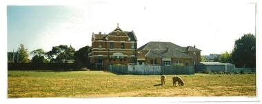
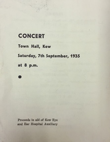 Kew Historical Society Inc
Programme - Concert Program, Concert, Town Hall, Kew, 1935
Program for a concert in the Walpole Street Town Hall in September 1935. The final page of the program includes advertisements for a draper and a chemist in HawthornFour page program for a concert in the Kew Town Hall, in Walpole Street, given on 7 September 1935. The proceeds of the concert were to be given to the Kew Eye and Ear Hospital Auxiliary.concerts - kew (vic) -
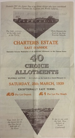 Kew Historical Society Inc
Plan - Subdivision Plan, Charteris Estate, East Ivanhoe, 1939
The Charteris Estate in Ivanhoe was sold in a number of sections. Copies of a subdivision plan of the first section is in the State Library of Victoria collection. This later section of the Charteris Estate includes lots in the Government Boulevard, Castella Street, McArthur Road, Burke Road North, Charteris Drive and Warncliff Road.Subdivision plans like that for the Charteris Estate are invaluable records for local historians identifying when lots in streets were promoted for sale.Four-fold brochure advertising the Charteris Estate in East Ivanhoe in 1939. Streets named on the plan include: the Government Boulevard, Castella Street, McArthur Road, Burke Road North, Charteris Drive and Warncliff Road. The brochure contains photos of Charterisville, the home of F De Castella Esq and also of attractive rolling hills. Annotations in pencilcharteris estate - east ivanhoe (vic), subdivision plans - east ivanhoe (vic) -
Port Melbourne Historical & Preservation Society
Document - Specification, Metalling and chanelling, Boundary Street South, Graham Street to St Vincents Street, Arthur Victor Heath, Town Clerk et al, 14 Mar 1893
Specifications (Reg. 77.1) and plan (Reg 77.2) for metalling and channelling Boundary Street South [Pickles Street] from Graham Street to St. Vincents Street. Loan works 1893, plan No. 5.A.V. Heath (Town Surveyor):J.J. Bartlett (Mayor)engineering - roads streets lanes and footpaths, town planning, town clerks, mayors, arthur victor heath, james john bartlett -
Port Melbourne Historical & Preservation Society
Plan - Metalling and chanelling, Boundary Street South, Graham Street to St Vincents Street, 14 Mar 1893
Specifications (Reg. 77.1) and plan (Reg 77.2) for metalling and channelling Boundary Street South [Pickles Street] from Graham Street to St. Vincents Street. Loan works 1893, plan No. 5.J.J. Bartlett (Mayor) 14/3/93engineering - roads streets lanes and footpaths, town planning, town clerks, mayors, arthur victor heath, james john bartlett -
 The Beechworth Burke Museum
Photograph
Taken in Beechworth, this photograph depicts the intersection of Camp Street with the Empire Hotel in the foreground and the post office in the background.Colored rectangular postcard printed on matt card. Obverse: Beautiful Beechworth (Vic) 1800 ft above Sea Level- Camp Street (Looking West) Copyright F. Foxcroft photo. Reverse: 7736.1 1997.2890 beechworth, camp street, post office, empire hotel -
 Melbourne Legacy
Slide, Legacy House in Market Street, 1950s
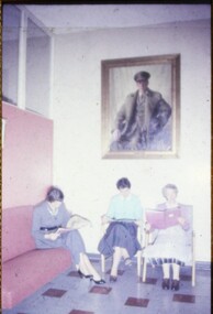
A slide image of three ladies in a waiting room, believed to be in the old Legacy House in Market Street, probably from the 1950s. The portrait of Stan Savige was painted by E. Buckmaster for the Archibald prize in 1946. Legacy rented the Market St premises for many years. It was part of the Western Market complex that was demolished and redeveloped in the early 1960s. Legacy held meetings, activities and the girls classes on the second floor of the building, accessed by this staircase, but it was barely fit for purpose. In the 1940s a generous donation by an anonymous donor meant Legacy could purchase a building at 342 Swanston St, but due to several factors were never able to inhabit it. Finally it was sold in 1954 and Junior Legacy Melbourne purchased 289-299 Swanston Street Melbourne (previously called Red Cross House) in 1956 from the Commonwealth Government and moved in after refurbishing it.A record of the Market Street building that Legacy occupied for many years until 1956-7.Colour slide of three ladies in the waiting room at Legacy House in Market Street in a yellow cardboard mount with piece of glass.Handwritten 'Waiting room Legacy House. Painting of founder in background' in blue pen on the slide mount.properties, market st, portrait -
 Halls Gap & Grampians Historical Society
Photograph - B/W, Oct-86
This is part of a parade held on the main street of Halls Gap in conjunction with the 150th anniversary of Major Mitchell's visit to the area. The photo shows three young girls and a dog standing as part of a crowd lining a street. Buildings , including a souvenier and newsagents and a cafe, can be seen behind the crowd. There are trees in the far background.events, parades -
Whitehorse Historical Society Inc.
Article, New workshop to go up in east
$200, 00 Mitcham property purchased to establish an industrial workshop complex for the handicapped of the eastern suburbs.$200, 00 Mitcham property purchased to establish an industrial workshop complex for the handicapped of the eastern suburbs. $38,000 was raised by NADRASCA. Property at Colombo Street, Mitcham. Federal grant provided bulk of the money.$200, 00 Mitcham property purchased to establish an industrial workshop complex for the handicapped of the eastern suburbs. disabled, nadrasca, colombo street, mitcham -
 Ballarat Heritage Services
Photograph - Photograph - Colour, Clare Gervasoni, Former Yandoit Hills School 2052 after being moved to Hepburn Springs, c2005, c2005
This building was moved from Yandoit Creek to the corner of Main Road and Seventh Street, Hepburn Springs. Colour photograph of on old schoolhouse that was moved from Yandoit Hills to the corner of Main Road and Seventh Street, Hepburn Springs. The building was used for religious services before being turned into a private residence. yandoit hills state school no 2052, education, hepburn springs, yandoit hills, yandoit creek -
 Kew Historical Society Inc
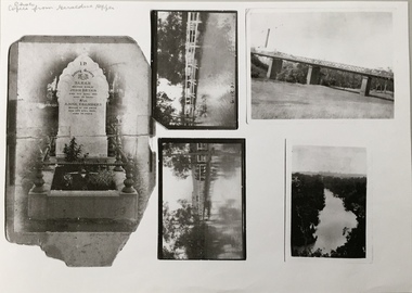
Photograph - Photocopy, Bryan Family Album, Twentieth Century
The Bryan family live din Princess Street, Kew.Photocopies of original photographs relating to or that belonged to the Bryan Family of Princess Street, Kew. The images include the headstone of Sarah Bryan and Anne Chambers; three photos of floods in Kew, one dated 1931; and a view of the River Yarra. bryan family (kew), kew -
 Ringwood and District Historical Society
Pamphlet, Land Sale Brochure Titled Eureka Plan Book - Seven Delightful & Valuable Ringwood Estates - circa 1925
Twenty page land sale brochure including photographs, subdivision features and local facilities. Additional flyer with conditions of sale and prices for estate blocks.Seven delightful and valuable Ringwood Estates called Bestpart, Paradise, Hill Top, Greenwood, Creek, Station, and School Estates. These nestle amidst the hills and valleys of beautiful Ringwood district. Also Goodluck Estate at Clarinda. Pamphlet marked as being From Mr. Farmer, No. 5 Flinders Court, Melbourne. Phone 988, 989 Central, or 55 Ringwood after 7 p.m. Plan of Ringwood School Estate includes William Street (later Kendall Street), Greenwood Avenue, Alton Street and Locke Street. Plan of Bestpart Estate, Ringwood, includes Bedford Road, Wilana Street, Greenwood Avenue, Caroline Street, Henry Street and Haig Street. Plan of Ringwood Station Estate includes Pitt Street, Bedford Road, Greenwood Avenue, Station Street, William Street (later Kendall Street, James Street, Wantirna Road, Caroline Street, Henry Street, Ellison Street and Haig Street. Plan of Geenwood Estate, Ringwood, includes Prussian Road (later Geenwood Avenue). Plan of Paradise Estate, Ringwood, includes Canterbury Road, Dandenong Road (Wantirna Road), Luck Street and Paradise Road. Plan of Creek Estate, Ringwood, includes Dandenong Creek, Wantirna Road and Gordon Crescent. Plan of Hill Top Estate, Ringwood (later Heathmont area), includes Heathmont Railway Station, Heathmont Road, Balfour Avenue, Lilian Street, Edith Street, Edna Street and Great Ryrie Street. Plan of Goodluck Estate, Clarinda, includes Talbot Avenue, Good Street, Luck Street, and Centre Road in locality plan between Oakleigh and Clayton Railway Stations. -
 Bendigo Historical Society Inc.
Domestic Object - 1927 CALENDAR, 1927
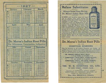
BHS Collection1927 Calendar: On blue paper with blue print within a border of fine blue lines is the 1927 calendar from January till June with a break in between for advertising for * Dr Morse's Indian Root Pills for Biliousness, Constipation, Indigestion. The calendar resumes July till December. On the back is printed in blue ink within a thin border is * Refuse Substitutes. Always insist upon having Dr. Morse's Indian Root Pills. Plus Dr. Morse's Indian Root Pills and the Comstock remedies. The W.H. Comstock Co., Ltd. 23 Lang Street, Sydney, N.S.W. Box 625Wholly set up and printed in Australia by The Snelling Printing Works, 52-54 Bay Street Sydney.ephemera, mementoes, dr. morse's indian root pills. w.h. comstock co., ltd. -
 Warrnambool and District Historical Society Inc.
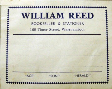
Label, William Reed Label, Early 20th century
. This label comes from the business of William Reed who ran a book and stationery store at 168 Timor Street, Warrnambool for many years in the 20th century. In 1976 advertisements indicated that the shop had been operating for 64 years which brings the establishment date to 1912 One date we have for William Reed's business is 1938 This label is of some importance as William Reed was a prominent business man in Warrnambool in the 20th century.White paper label with blue printing adhered to a piece of grey cardboard. Another label is on the same card.WILLIAM REED BOOKSELLER & STATIONER. 168 Timor Street, Warrnambool "AGE" "SUN" "HERALD" Border and horizontal lines. william reed, warrnambool, bookseller -
Port Melbourne Historical & Preservation Society
Photograph - Graham Street Rockery
The rockery and buildings in this area of Graham Street were demolished in the 1970s when the Graham Street overpass was constructed.View of ornamental reserve (rockery) in Graham Street with many people, men, women and children standing in front of the rockery and a number of two-storey buildings in the background. The decorative lights of the Maskell & McNab Memorial are visible within the rockery. There is a bicycle leaning against the wall of the rockery at the centre of the image.graham street, parks and gardens, frederick william maskell, james mcnab, maskell & mcnab memorial -
![Toast 25-5-1986 [Hallatrow]](/media/collectors/550653872162f11fb04854aa/items/5e3037ba21ea6717786eae87/item-media/5e3038b121ea6717786f92e1/item-fit-380x285.jpg) Kew Historical Society Inc
Kew Historical Society IncDocument, Toast 25-5-1986 [Hallatrow], 1986
Hallatrow is located at 6 Holroyd Street Kew. It was the home of Thomas Brodribb. The notes were written by his descendant and recall his family's occupation of the house.A manuscript, written by Jim Brodribb, the grandson of Thomas Brodribb, the original owner of Hallatrow, recalling his family's years at Hallatrow (now 6 Holroyd Street in Studley Park.) hallatrow - 6 holroyd street - kew )vic), historic buidlings - studley park - kew (vic) -
 Whitehorse Historical Society Inc.
Document, Certificate of Title, 1/06/1951
Certificate of Title Vol 7583 Fol 060, being Lot 72 on Plan of Subdivision No 6626, 50 Burnett Street, Mitcham, with Plan of Subdivision No 6626 including Burnett Street, Thomas Street, bordered by Cook Street and Cook Street and Whitehorse Road, Mitchamburnett street, mitcham, no 50, thomas street, cook road, whitehorse road -
 Whitehorse Historical Society Inc.
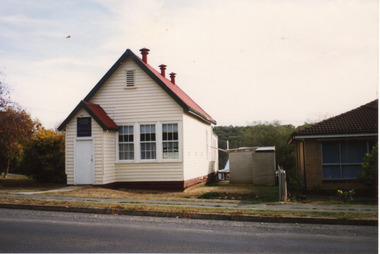
Photograph, Miner's cottage - Halley Street, Blackburn
The gold mine in Halley Street is understood to have operated successfully until 1880. Being close to the southern end of Blackburn Lake and to the course of Gardiner's Creek, the mine suffered from continuous water seepage and was eventually abandoned. The mine was filled in soon after 1904Black and white photograph of the front of a miner's cottage in Halley Street Blackburn. Raspberry canes on sticks. Joseph Cramp on left in the black waistcoathalley street, blackburn, gold mining, cramp, joseph -
 Surrey Hills Historical Society Collection
Photograph, Mont Albert Central School Grade 3R, 1955, 1955
Mont Albert State School was officially opened on 23rd April 1917. The school became Mont Albert Central School in 1918, taking in Forms 1 and 2. The school remained a Central School until 1964, when the secondary years formed the basis of a new High School, the Box Hill North High School, later to be named Koonung Secondary College. As Laurie was in the photo of Class 2B, this photo may include one of her siblings. This is part of a large collection of material related to the Deakin, Mair and Young families, all with connections to Surrey Hills and Mont Albert. Laurie Young was the daughter of Beryl Mair (1916-1976) and Ernest Lance Young (1915-1999). The family lived at 5 York Street and later 11 York Street, Mont Albert. Laurie was born on 18 August 1947. Black and white class photo taken outside the school building. The class of 20 girls and 29 boys. Not all children are wearing school uniform. The children are flanked by an older gentleman wearing glasses (left facing) and a younger woman (right facing).Photographer's identification stamp in black ink " L.E. Reynolds / PHOTOGRAPHER / 35 RUSSELL STREET, / SURREY HILLS, E10"mont albert central school, laurie young, laurie newton, education -
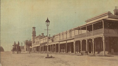
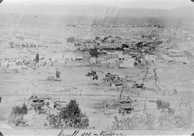 Stawell Historical Society Inc
Photograph, Panorama of Stawell from Big Hill 1878, North Scotchmans No6 and No7 and South Cross Mine whims and Poppet Heads
Scene from Big Hill. Shows Stawell looking to West c 1878 Patrick Streets and Sloane Street intersection. Back of Royal Exchange Hotel Kays Foundry in Wimmera Street. Coffee Palace formerly Castlemaine Hotel at right of photo. Mining poppet heads in foreground Three Whims in the foreground are North Scotchmans No 6 & 7 and South Cross in CentreSepia toned print & also a Black & White print (these photos are similar to 29.9). Photos show Western view of mining activity in Stawell c 1878. Kays Foundry on upper left and Upper Main Street on very right of photo.Stawell 1878 in Victoria.stawell, mining, panorama, streatscape