Showing 3060 items
matching 1884-1887
-
 Kew Historical Society Inc
Photograph - Kew Railway Station, 1951
The Kew railway was opened in 1887, and diverged from the main (Box Hill–Lilydale) line about half-way between Hawthorn and Glenferrie. From the point of divergence the line was slightly less than one mile long, and it had only one intermediate station — Barker. There were four road over-bridges and two level crossings, including one over the busy Barkers Road. The line supported a passenger and goods service, and was electrified in December 1922, at the same time as the main line to Box Hill. There were a number of peak hour services which ran from Flinders Street station (Melbourne) to Kew, but in 1938 all but one of these were diverted to the Ashburton line, where traffic was growing. This had an adverse effect on Kew traffic, as passengers from Kew needed to cross over a footbridge at Hawthorn to change trains, and the main line trains were usually already crowded by the time they reached Hawthorn. At about the same time the off-peak trains were replaced by road buses. In 1952 all passenger trains were withdrawn, but the road bus service continued for many years. Goods trains were finally withdrawn in 1957, and the railway was dismantled in 1958-59. (Source: Frank Stamford, 'The Hawthorn - Kew Railway')Small black and white snapshot of Kew Railway Station in 1950. The photograph, one of 12, is part of a larger album of newspaper clippings, timetables, tickets and photos relating to the Kew Railway Line, taken and compiled by Lachlan Richardson, while a resident of Kew. The album dates from the 1950s. The album is part of a larger subject file on the Kew Line, compiled over time by members of the Kew Historical Society."Kew Station / 14/51 / 22/4/51 F5"kew railway line, transport -- railways -- kew (vic.), kew branch line, kew railway station -
 Kew Historical Society Inc
Photograph - Kew Branch Line: Weeds at Kew Station 14/51
The Kew railway was opened in 1887, and diverged from the main (Box Hill–Lilydale) line about half-way between Hawthorn and Glenferrie. From the point of divergence the line was slightly less than one mile long, and it had only one intermediate station — Barker. There were four road over-bridges and two level crossings, including one over the busy Barkers Road. The line supported a passenger and goods service, and was electrified in December 1922, at the same time as the main line to Box Hill. There were a number of peak hour services which ran from Flinders Street station (Melbourne) to Kew, but in 1938 all but one of these were diverted to the Ashburton line, where traffic was growing. This had an adverse effect on Kew traffic, as passengers from Kew needed to cross over a footbridge at Hawthorn to change trains, and the main line trains were usually already crowded by the time they reached Hawthorn. At about the same time the off-peak trains were replaced by road buses. In 1952 all passenger trains were withdrawn, but the road bus service continued for many years. Goods trains were finally withdrawn in 1957, and the railway was dismantled in 1958-59. (Source: Frank Stamford, 'The Hawthorn - Kew Railway')Small black and white snapshot of how the Kew Branch Line was allowed to run down. The photograph, one of 12, is part of a larger album of newspaper clippings, timetables, tickets and photos relating to the Kew Railway Line, taken and compiled by Lachlan Richardson, while a resident of Kew. The album dates from the 1950s. The album is part of a larger subject file on the Kew Line, compiled over time by members of the Kew Historical Society.kew railway line, transport -- railways -- kew (vic.), barker railway station, kew branch line -
 Kew Historical Society Inc
Photograph - Kew Railway Station, May 1950
The Kew railway was opened in 1887, and diverged from the main (Box Hill–Lilydale) line about half-way between Hawthorn and Glenferrie. From the point of divergence the line was slightly less than one mile long, and it had only one intermediate station — Barker. There were four road over-bridges and two level crossings, including one over the busy Barkers Road. The line supported a passenger and goods service, and was electrified in December 1922, at the same time as the main line to Box Hill. There were a number of peak hour services which ran from Flinders Street station (Melbourne) to Kew, but in 1938 all but one of these were diverted to the Ashburton line, where traffic was growing. This had an adverse effect on Kew traffic, as passengers from Kew needed to cross over a footbridge at Hawthorn to change trains, and the main line trains were usually already crowded by the time they reached Hawthorn. At about the same time the off-peak trains were replaced by road buses. In 1952 all passenger trains were withdrawn, but the road bus service continued for many years. Goods trains were finally withdrawn in 1957, and the railway was dismantled in 1958-59. (Source: Frank Stamford, 'The Hawthorn - Kew Railway')Small black and white snapshot of Kew Railway Station inMay 1950. The photograph, one of 12, is part of a larger album of newspaper clippings, timetables, tickets and photos relating to the Kew Railway Line, taken and compiled by Lachlan Richardson, while a resident of Kew. The album dates from the 1950s. The album is part of a larger subject file on the Kew Line, compiled over time by members of the Kew Historical Society."Kew Railway Station, May 1950"kew railway line, transport -- railways -- kew (vic.), kew branch line, kew railway station -
 Kew Historical Society Inc
Photograph - The last train at Barker Station, 1952
The Kew railway was opened in 1887, and diverged from the main (Box Hill–Lilydale) line about half-way between Hawthorn and Glenferrie. From the point of divergence the line was slightly less than one mile long, and it had only one intermediate station — Barker. There were four road over-bridges and two level crossings, including one over the busy Barkers Road. The line supported a passenger and goods service, and was electrified in December 1922, at the same time as the main line to Box Hill. There were a number of peak hour services which ran from Flinders Street station (Melbourne) to Kew, but in 1938 all but one of these were diverted to the Ashburton line, where traffic was growing. This had an adverse effect on Kew traffic, as passengers from Kew needed to cross over a footbridge at Hawthorn to change trains, and the main line trains were usually already crowded by the time they reached Hawthorn. At about the same time the off-peak trains were replaced by road buses. In 1952 all passenger trains were withdrawn, but the road bus service continued for many years. Goods trains were finally withdrawn in 1957, and the railway was dismantled in 1958-59. (Source: Frank Stamford, 'The Hawthorn - Kew Railway')Small black and white snapshot of the last passenger train at Barker Railway Station in 1952. The photograph, one of 12, is part of a larger album of newspaper clippings, timetables, tickets and photos relating to the Kew Railway Line, taken and compiled by Lachlan Richardson, while a resident of Kew. The album dates from the 1950s. The album is part of a larger subject file on the Kew Line, compiled over time by members of the Kew Historical Society."Last train at Barker Station / 1 August 1952"kew railway line, transport -- railways -- kew (vic.), barker railway station, kew branch line -
 Kew Historical Society Inc
Photograph - Seven Carriage Train at Barker Station, 1952
The Kew railway was opened in 1887, and diverged from the main (Box Hill–Lilydale) line about half-way between Hawthorn and Glenferrie. From the point of divergence the line was slightly less than one mile long, and it had only one intermediate station — Barker. There were four road over-bridges and two level crossings, including one over the busy Barkers Road. The line supported a passenger and goods service, and was electrified in December 1922, at the same time as the main line to Box Hill. There were a number of peak hour services which ran from Flinders Street station (Melbourne) to Kew, but in 1938 all but one of these were diverted to the Ashburton line, where traffic was growing. This had an adverse effect on Kew traffic, as passengers from Kew needed to cross over a footbridge at Hawthorn to change trains, and the main line trains were usually already crowded by the time they reached Hawthorn. At about the same time the off-peak trains were replaced by road buses. In 1952 all passenger trains were withdrawn, but the road bus service continued for many years. Goods trains were finally withdrawn in 1957, and the railway was dismantled in 1958-59. (Source: Frank Stamford, 'The Hawthorn - Kew Railway')Small black and white snapshot of a seven carriage train approaching Barker Railway Station. The photograph, one of 12, is part of a larger album of newspaper clippings, timetables, tickets and photos relating to the Kew Railway Line, taken and compiled by Lachlan Richardson, while a resident of Kew. The album dates from the 1950s. The album is part of a larger subject file on the Kew Line, compiled over time by members of the Kew Historical Society."Seven Carriage Train at Barker Station"kew railway line, transport -- railways -- kew (vic.), barker railway station, kew branch line -
 Kew Historical Society Inc
Photograph - Barker Station, August 1952, 1952
The Kew railway was opened in 1887, and diverged from the main (Box Hill–Lilydale) line about half-way between Hawthorn and Glenferrie. From the point of divergence the line was slightly less than one mile long, and it had only one intermediate station — Barker. There were four road over-bridges and two level crossings, including one over the busy Barkers Road. The line supported a passenger and goods service, and was electrified in December 1922, at the same time as the main line to Box Hill. There were a number of peak hour services which ran from Flinders Street station (Melbourne) to Kew, but in 1938 all but one of these were diverted to the Ashburton line, where traffic was growing. This had an adverse effect on Kew traffic, as passengers from Kew needed to cross over a footbridge at Hawthorn to change trains, and the main line trains were usually already crowded by the time they reached Hawthorn. At about the same time the off-peak trains were replaced by road buses. In 1952 all passenger trains were withdrawn, but the road bus service continued for many years. Goods trains were finally withdrawn in 1957, and the railway was dismantled in 1958-59. (Source: Frank Stamford, 'The Hawthorn - Kew Railway')Small black and white snapshot of the last passenger train at Barker Railway Station in 1952. The photograph, one of 12, is part of a larger album of newspaper clippings, timetables, tickets and photos relating to the Kew Railway Line, taken and compiled by Lachlan Richardson, while a resident of Kew. The album dates from the 1950s. The album is part of a larger subject file on the Kew Line, compiled over time by members of the Kew Historical Society."Barker Station / August 1952"kew railway line, transport -- railways -- kew (vic.), barker railway station, kew branch line -
 Kew Historical Society Inc
Photograph - Kew Branch Line : The Hawthorn Grove crossing, August 1952, 1952
The Kew railway was opened in 1887, and diverged from the main (Box Hill–Lilydale) line about half-way between Hawthorn and Glenferrie. From the point of divergence the line was slightly less than one mile long, and it had only one intermediate station — Barker. There were four road over-bridges and two level crossings, including one over the busy Barkers Road. The line supported a passenger and goods service, and was electrified in December 1922, at the same time as the main line to Box Hill. There were a number of peak hour services which ran from Flinders Street station (Melbourne) to Kew, but in 1938 all but one of these were diverted to the Ashburton line, where traffic was growing. This had an adverse effect on Kew traffic, as passengers from Kew needed to cross over a footbridge at Hawthorn to change trains, and the main line trains were usually already crowded by the time they reached Hawthorn. At about the same time the off-peak trains were replaced by road buses. In 1952 all passenger trains were withdrawn, but the road bus service continued for many years. Goods trains were finally withdrawn in 1957, and the railway was dismantled in 1958-59. (Source: Frank Stamford, 'The Hawthorn - Kew Railway')Small black and white snapshot of the Hawthorn Grove crossing, August 1952. The photograph, one of 12, is part of a larger album of newspaper clippings, timetables, tickets and photos relating to the Kew Railway Line, taken and compiled by Lachlan Richardson, while a resident of Kew. The album dates from the 1950s. The album is part of a larger subject file on the Kew Line, compiled over time by members of the Kew Historical Society.kew railway line, transport -- railways -- kew (vic.), kew branch line, hawthorn grove -- hawthorn (vic.), railway crossings -
 Kew Historical Society Inc
Photograph - Kew Station 22/4/51, F3, 1952
The Kew railway was opened in 1887, and diverged from the main (Box Hill–Lilydale) line about half-way between Hawthorn and Glenferrie. From the point of divergence the line was slightly less than one mile long, and it had only one intermediate station — Barker. There were four road over-bridges and two level crossings, including one over the busy Barkers Road. The line supported a passenger and goods service, and was electrified in December 1922, at the same time as the main line to Box Hill. There were a number of peak hour services which ran from Flinders Street station (Melbourne) to Kew, but in 1938 all but one of these were diverted to the Ashburton line, where traffic was growing. This had an adverse effect on Kew traffic, as passengers from Kew needed to cross over a footbridge at Hawthorn to change trains, and the main line trains were usually already crowded by the time they reached Hawthorn. At about the same time the off-peak trains were replaced by road buses. In 1952 all passenger trains were withdrawn, but the road bus service continued for many years. Goods trains were finally withdrawn in 1957, and the railway was dismantled in 1958-59. (Source: Frank Stamford, 'The Hawthorn - Kew Railway')Small black and white snapshot of Kew Railway Station, looking south to Barker Station. The photograph, one of 12, is part of a larger album of newspaper clippings, timetables, tickets and photos relating to the Kew Railway Line, taken and compiled by Lachlan Richardson, while a resident of Kew. The album dates from the 1950s. The album is part of a larger subject file on the Kew Line, compiled over time by members of the Kew Historical Society.kew railway line, transport -- railways -- kew (vic.), kew branch line, kew railway station -
 Kew Historical Society Inc
Photograph - Kew Railway Station: Denmark Street entrance, 1952
The Kew railway was opened in 1887, and diverged from the main (Box Hill–Lilydale) line about half-way between Hawthorn and Glenferrie. From the point of divergence the line was slightly less than one mile long, and it had only one intermediate station — Barker. There were four road over-bridges and two level crossings, including one over the busy Barkers Road. The line supported a passenger and goods service, and was electrified in December 1922, at the same time as the main line to Box Hill. There were a number of peak hour services which ran from Flinders Street station (Melbourne) to Kew, but in 1938 all but one of these were diverted to the Ashburton line, where traffic was growing. This had an adverse effect on Kew traffic, as passengers from Kew needed to cross over a footbridge at Hawthorn to change trains, and the main line trains were usually already crowded by the time they reached Hawthorn. At about the same time the off-peak trains were replaced by road buses. In 1952 all passenger trains were withdrawn, but the road bus service continued for many years. Goods trains were finally withdrawn in 1957, and the railway was dismantled in 1958-59. (Source: Frank Stamford, 'The Hawthorn - Kew Railway')Small black and white snapshot of the entrance to Kew Station from Denmark Street in 1952. The photograph, one of 12, is part of a larger album of newspaper clippings, timetables, tickets and photos relating to the Kew Railway Line, taken and compiled by Lachlan Richardson, while a resident of Kew. The album dates from the 1950s. The album is part of a larger subject file on the Kew Line, compiled over time by members of the Kew Historical Society.kew railway line, transport -- railways -- kew (vic.), kew branch line, kew railway station -
 Eltham District Historical Society Inc
Book - Cook Book, Mary Rundell, A New System of Domestic Cookery; formed upon principles of economy and adapted to the use of private families. With Ten Illustrations. By a Lady, 1849
First published in 1806 by John Murray and written by Maria Rundell, later editions were "By a Lady". https://en.wikipedia.org/wiki/A_New_System_of_Domestic_Cookery A legal dispute arose between Murray and Rundell over the copyright of the cookery book titled "A New System of Domestic Cookery" by Mary Eliza Rundell. The book, which was published in 1806, gained immense popularity over the years. In 1821, Murray claimed that Rundell had infringed on his copyright by publishing a new edition of the book without his permission. The case was brought to court, and after much debate, it was ruled that Rundell had indeed infringed on Murray's copyright. The court ordered her to pay damages and to stop publishing the book without Murray's consent. This ruling was significant as it established the legal precedent that copyright law applied to books and other written works. - Based on an article from The Edinburgh Annual Register, 1821 Robert William Whatmough (1815 Heywood, Lancashire-1887 Diamond Creek, Victoria) and his wife Mary Hill ( 1813 Rochdale, Lancashire - 1881 Greensborough, Victoria) were pioneer settlers on the Plenty River at Greensborough. Their daughter, Jemima Whatmough (1840-1926) married Robert Fielding (1820-1891) who were the parents of Thomas Edmund Fielding and great grandparents of Tom FieldingInscribed inside front leaf facing page in ink: Robert Whatmough Plenty River 1858tom fielding collection -
 Wodonga & District Historical Society Inc
Domestic object - Ceramic toast rack, Maruhon Ware, 1920s
This item is from a collection donated by descendants of John Francis Turner of Wodonga. Mr. Turner was born on 6 June 1885. He completed all of his schooling at Scotts Boarding School in Albury, New South Wales. On leaving school, he was employed at Dalgety’s, Albury as an auctioneer. In 1924 John was promoted to Manager of the Wodonga Branch of Dalgety’s. On 15/03/1900 he married Beatrice Neal (born 7/12/1887 and died 7/2/1953) from Collingwood, Victoria. They had 4 daughters – Francis (Nancy), Heather, Jessie and Mary. In 1920, the family moved From Albury to Wodonga, purchasing their family home “Locherbie” at 169 High Street, Wodonga. "Locherbie" still stands in Wodonga in 2022. The collection contains items used by the Turner family during their life in Wodonga. Japanese pottery and ceramics had varying basemarks, particularly those designed for export. Some restrictions were due to requirements imposed by other countries after WW2. This Japanese type of china was advertised in the 1920's and 1930's. During the years of the American occupation of Japan (1945-1952), all exports from Japan were marked "Made in Occupied Japan" and after the occupation simply "Japan". This information helps to establish the provenance of items such as this toast rack.This item is representative of ceramic domestic items used in Australian homes in the 1920s and 1930s.A ceramic rectangular toast rack decorated with a cherry design. Each end is shaped as a shallow bowl and there are 3 upright dividers to support slices of toast. The cherry design is hand painted and then glazed. The bottom centre is stamped with MARUHON WARE, HAND PAINTED, JAPAN around a K in a circle.Underneath "Maruhon Ware/ K in circle/ HANDPAINTED/ JAPAN"domestic items, japanese pottery -
 Wodonga & District Historical Society Inc
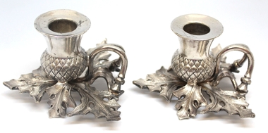
Domestic object - Britannia metal thistle shaped chamber sticks, James Dixon & Sons, c1921
This item is from a collection donated by descendants of John Francis Turner of Wodonga. Mr. Turner was born on 6 June 1885. He completed all of his schooling at Scotts Boarding School in Albury, New South Wales. On leaving school, he was employed at Dalgety’s, Albury as an auctioneer. In 1924 John was promoted to Manager of the Wodonga Branch of Dalgety’s. On 15/03/1900 he married Beatrice Neal (born 7/12/1887 and died 7/2/1953) from Collingwood, Victoria. They had 4 daughters – Francis (Nancy), Heather, Jessie and Mary. In 1920, the family moved From Albury to Wodonga, purchasing their family home “Locherbie” at 169 High Street, Wodonga. "Locherbie" still stands in Wodonga in 2022. The collection contains items used by the Turner family during their life in Wodonga. The hallmark on this item identifies it as being produced by James Dixon and Sons of Sheffield, England. Their first corporate mark of the trumpet (bugle) and banner was granted in 1879, and the second with the name was added in 1890 and used until 1920, therefore helping to establish provenance of this set. The mark JD&S was used from c. 1920. The abbreviation EPBM in the hallmark denotes "electroplated Britannia metal". Britannia metal was generally used as an alternative to electroplated nickel silver.This item comes from a collection used by a prominent citizen of Wodonga. It is also an excellent example of Britannia ware of the early 20th century.A pair of Britannia metal chamber sticks with a base representing the shape of a thistle and its leaves. Underneath each stick, Beneath the symbol of a bugle and banner, surrounded by shields "J D & S"/E P B M/ 8207"domestic items, britannia metal -
 Flagstaff Hill Maritime Museum and Village
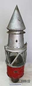
Functional object - Marine Navigation Light, Early 20th century
Breakwater navigation lights are placed at the end of the breakwaters to warn incoming vessels of the end of the structure, as a marine safety measure. The subject item was such a light believed to have been placed at the end of Warrnambool's breakwater around 1915 when it was extended. The light had remained in place for many years until it was probably removed when the structure was undergoing rock armouring repairs to the end of the breakwater in 1975. The light had been placed in a council storage shed probably from the time when the structure was undergoing these repairs in 1975. In 2014 the light was removed from the storage shed and donated to Flagstaff Hill museum. History: Warrnambool breakwater plans were drawn up by 1874 and approval was given for preliminary construction work to start but when the money ran out, the works stopped. With a number of quick changes of government the “Warrnambool” breakwater project was kicked from one Victorian state government to another. Then finally in 1879, the eminent British harbour engineer Sir John Coode was asked to design a breakwater. His first design was for a 1800 feet long structure but that was scaled back to 900 feet and construction finally began in 1884. This structure was attributed in causing major siltation of Lady bay, as a consequence the breakwater was again extended in 1915. In 1975, the rock armouring at the end of the breakwater was added but by 1979 another impact study was calling for the breakwater to be removed altogether. The Heritage Council Victoria, regard the Warrnambool breakwater is of historical significance to the state as one of the most important maritime engineering projects that was undertaken in Victoria during the late nineteenth century. The light is also as part of this structure regarded as a significant item of historical interest.Marker light or navigation light. Round light stand with conical top piece (2 separate pieces). Metal base painted red, clear glass middle section enclosed by metal frame, metal cone shaped top section painted silver. Electrical wiring can be seen inside centre section. Pole that light would have been on to elevate it is missing.Has metal plate screwed onto side of base engraved "23". flagstaff hill, warrnambool, shipreck coast, flagstaff hill maritime museum, maritime museum, great ocean road, warrnambool breakwater, marker light, naviagtion light, breakwater navigation light -
 Uniting Church Archives - Synod of Victoria
Photograph, Mitiamo UC Centenary & Rev. V. Raymond Hicks 11/11/1984, 11/11/1984
Victor Raymond Hicks (11/8/1903–19/11/1995) born at Ballarat. Trained at Otira and accepted as candidate for the ministry in 1927. Ordained 1934. Married Lillian Harvey, 4 children. Appointments to Mitiamo, Matimuk, Woomelang, Wodonga, Kerang, Springvale, Brunswick, North Fitzroy, Geelong West, Kyneton and Brown Hill (Ballarat). Chaplaincy in WW2 and at Box Hill hospital. The article about the Mitiamo church: "Fifty years ago the Rev. Raymond Hicks was minister at Mitiamo as it celebrated its Golden Jubilee. He returned for the centenary this year and powerfully preached on 'Lengthen your cords, and strengthen your stakes' (Isaiah 54:2). He spoke of the great need of the church today to have a passion to lead men and women to Christ. Also sharing in the service were the Rev. Ray Scholl, a Mitiamo member before entering the ministry, and present minister, the Rev. M. Thalheimer. The centenary weekend began with an old fashioned tea meeting and concert. The Sunday school hall housed a comprehensive display of photos and historical records dating back to the Bible Christian days of 1884. Mrs Thirza Phelan has researched and written the church history. FOOTNOTE: The first minister, Mitiamo's the Rev. Daniel Daley, preached at the Golden Jubilee service—Mr Hicks has followed an ancient tradition."Colour photograph of Rev. V. Raymond Hicks standing outside the front of a wooden church porch.C&N identification.rev raymond hicks, home missionary, methodist ministry, otira -
 Kew Historical Society Inc
Postcard, Victoria Street Bridge, Collingwood, 1905-1913
Victoria Bridge is a riveted and welded steel Warren truss bridge over the Yarra River completed in 1884 to a design by Fraser & Chase following a controversial design competition held in 1880. Funds for the bridge's construction were provided by the councils of Collingwood, Hawthorn, Kew and Richmond. The contract was awarded to Mr P. Platt. Charles Rowand was officially appointed Supervising Engineer in 1883. The winning design was based on the theoretical work of William Charles Kernot (1845-1909) who campaigned for economy in public works design and the application of scientific principles in engineering. ... The bridge was widened in 1890 by the addition of a third line of truss on new piers on the up stream side to carry horse trams. Work commenced in 1914 to convert the horse tramway to an electric tramway by the Prahran & Malvern Tramways Trust, part of the Trust's extension of its tramway into the eastern suburbs between 1913-18. In 1915 the bridge was further strengthened to accommodate the extra weight of electric trams and widened by the addition of two six feet cantilever footpaths. During this period the Prahran & Malvern Tramways Trust erected two ornamental gantries over the roadway to support overhead wires for the electric tramway. Further widening and reconditioning of the bridge took place in 1933, including the addition of four new welded trusses, two intermediate and two on the outside. The latter were supported on new cantilevered truss cross beams attached to the top of the piers. (Source: Heritage Victoria)Early and rare postcard of the Victoria Street Bridge linking Victoria Street and Barkers Road.Polychrome postcard of the Victoria Street Bridge which links Richmond and Abbotsford with Kew and Hawthorn.View from Harrison Cres embankment / former Xavier College boatshed on site of tree in foreground. / Chimney left corner - Wool Scoring Mils in Victoria St. / On horizon - Studley Villa, Studley House circa 1880s, Studley Hall / Chinese gardens to be seen behind three set of columns / M.J. Slatterypostcards -- yarra river, postcards -- bridges. -- greater melbourne (vic.), victoria street bridge -
 Eltham District Historical Society Inc
Photograph, Eltham Cemetery Trust, Grave of Michael and Bridget Cecilia Dillon, Eltham Cemetery, Victoria, 4 May 2016
Bridget was the daughter of John Wright MURRAY(1816-1867) and Mary SWEENEY(1833-1909). She married Hamilton DRAIN(1847-1886) in 1884 and they had a daughter, Mary Ellen DRAIN(1886-1888). Following husband Hamilton Drain’s death in 1886, and her infant daughter Mary’s death in 1888, Bridget married Michael Dillon in 1894. It appears that she and Michael had no children together. Electoral roll records indicate that Michael was a farmer and that he and Bridget lived in Research, Vic. Some damage has occurred to their monument and the Eltham Cemetery Trust would like to locate a next of kin or family member. Unfortunately, there was no purchase information recorded, only the following details; no next of kin. Deceased Location Date of Death Interment Date Michael Dillon Roman Catholic 205 10/12/1916 11/12/1916 Bridget Cecilia Dillon Roman Catholic 206 7/04/1927 19/04/1927 The photo of the headstone is dated 4 May 2016, which provides the best detail of the inscription.The headstone has deteriorated further in the last few years. In Loving Memory of Michael Dillon Died 10th Dec. 1916 Aged 65 years Also Bridget Cecilia Wife of the above Died 17th April 1927 Aged 78 years R.I.PBorn Digitaleltham cemetery, gravestones, michael dillon, bridget cecilia dillon (nee sweeeney) -
 Flagstaff Hill Maritime Museum and Village
Instrument - Scale, George Salter & Co, Circa 1921
The Hughes’ Family Scale No. 48 is a spring balance scale. It uses the Imperial measurements of ounces and pounds. There are 16 ounces (OZ) in one pound (LB), and each pound equals approximately 454 grams in Metric measurements. Scales have been used to measure and compare items for value for centuries. A weight was placed on one side of a balance and the object was placed on the other. Adjustments were made to either the weight or the object until the balance was horizontal, which meant that each side was the same weight. The Salter family business began in 1760 with spring makers, Richard and William Salter. In the late 18th century, Richard Salter invented the spring scale, where the weight of an object on the tray of the scale causes pressure on a spring in the scale. The pressure caused by gravity was then measured to calculate the weight of an object. Spring scales are still used today along with the more recent and accurate digital scales. The company began manufacturing in West Bromwich, England, in 1770. The firm was taken over by William’s sons, John and George. In 1824, after the death of John, the firm became George Salter & Co. The company produced a wide variety of products, including Britain’s first bathroom scale and the first English typewriter. In 1884 the Salter Trademark of a Staffordshire knot pierced by an arrow was registered. After over 100 years of manufacturing, the company was bought out by Staveley Industries, which was bought by Weigh-Tronix, and then that company was bought by HoMedics Company in 2004.This scale was made by Salter, the company that invented the balance scale, the first British bathroom scale and the first English typewriter. The scale represents the domestic equipment used for measuring in food preparation over 100 years ago. Modern kitchen scales are still using the same principal, along with scales used in business and industry.Scale; a domestic spring balance scale for measuring weight from 0 to 20 pounds. The scale’s grey metal case has a round white dial on the front with black markings, an arrow indicator and a round shallow metal bowl on a pedestal at the top. The scale is raised on a rectangular metal base with outward-sloping sides. An adjustable screw is on the dome top. The scale is marked from 0 to 20 pounds, with each pound marked in 1-ounce increments. The scale is named the Hughes Family Scale No. 48 and was made in Britain by Salter.“HUGHES’ / FAMILY SCALE / No. 48” “BRITISH MADE” “TO WEIGH 20 LBS BY 1 OZ” “SALTER” above logo [knotted rope with an arrow through loops]flagstaff hill, warrnambool, maritime museum, maritime village, great ocean road, shipwreck coast, hughes, salter, british made, family scale, no. 48, spring balance, scale, weighing instrument, weights and measures, weighing machine, kitchen utensil, baking accessory, domestic equipment, cookware, bakeware, kitchen scale, kitchen accessory, food preparation, recipes, cooking, measuring -
 The Beechworth Burke Museum Research Collection
Card (Series) - Index Card, George Tibbits, Ford Street, Beechworth, 1976
George Tibbits, University of Melbourne. Faculty of Architecture, Building and Town & Regional PlanningIndex system that support the research for Beechworth : historical reconstruction / [by] George Tibbits ... [et al]Arranged by street names of BeechworthEach index card includes: street name and number of property, image of property, allotment and section number, property owners and dates of ownership, description of the property according to rate records, property floor plan with dimensions.beechworth, george tibbitsbeechworth, george tibbits -
 City of Greater Bendigo - Civic Collection
Painting - Portrait of William Abendigo Thompson, c 1890
William Abendigo Thompson was English bare-knuckle boxer born in Nottingham, 1811- 1880 and whose name is (allegedly) borne by the City of Greater Bendigo. One of 21 children he started fighting aged 18 and began prizefighting aged 21. His career spanned from 1832–50, and is said to have lost only one fight. Later in life, after spending time in prison he became a Methodist evangelist preacher. While the artist and date of production of this work are unknown the initials JJLh (or n?) are just legible lower right on canvas. Other clues for an approximate date of creation include the similarity in composition of this painting to a popular aquatint of Bendigo by Charles Hunt Senior (1803 - 77). Based on the markings on the back of the canvas for Rowney and Co and the address given, we can ascertain that the canvas itself was manufactured between 1884 - 1896. The painting also includes an extract of the Conan Doyle poem 'Bendigo's Sermon' which was written in 1911. Given these three factors, a date for the painting can be surmised as post 1911. Stretched made by George Rowney’s is one of very few artists’ supply businesses with origins in the 18th century still trading today, as Daler-Rowney, albeit no longer in family hands. The business has been a significant supplier of canvases and panels from the 1810s. Naive, Primitive, British0348.1 Framed oil painting of the bare fisted knuckle fighter William Abendigo Thompson painted in a naïve style. Depicts Thompson, bare chested in an outdoor fighting ring with his fists raised with a water bucket at this feet. 0348.2 Typed note re the history of the naming of the City of Bendigo.Top centre front of painting; You didn’t know of Bendigo? That knocks me out! Who’s your board school teacher? What’s he about? Chock a block with fairy tales – full of useless cram And haven’t heard o' Bendigo the pride of Nothin’ All sing along together lower centre painting; William Abendigo Thompson centre Inner wooden frame; bendigo back of canvas; Geo. Rowney & Co 64 Oxford Street and Princes Ball Piccadilly London W sticker lower centre back of frame; donors name and address. Initials illegible lower right.city of greater bendigo sport -
 The Beechworth Burke Museum Research Collection
Card - Index Card, George Tibbits, Ford Street, Beechworth, 1976
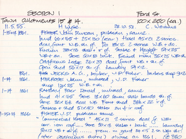
Property - Ford Street Beechworth - Section 1, Town Allotment 14 & 15 - 100' x 250' each Ownership details and history - 28 Oct 1853 - C. Williams - 11 Nov 1855 - H. Wyse 1-15&14 - 1861 - Fisher, John Duncan - publican, same. Land 66'x165' + 25'x130' (rear) Hotel 45'x21' 2 stories, deal front WB. sh. rf. Do 18'x12' 2 stories WB & Do. Kitchen 38'x13' slab + ir rf. Stable & Hayloft 54'x25' WB & sh. Store 50'x18' bark. Billiard room 35'x25' WB + sh. Oddfellows Lodge 26'x29' deal front WB + sh. rf. Open shed. 56'x17' sh. rf. Laundry 54'x12'. 1861 - Jecks A.G. barber, J.D. Fisher barbers shop 9'x8' 1-14 - 1861 - Melrose, John, unlisted J.D. Fisher shop 13'x25' WB + sh. 1-14 - 1861 - Ramsay, Peter Donald, unlisted, same, land 41'x165' store 18'x60' sawn slab boards sh. rf. store 32'x 16'6"deal WB Front Shed 38'6"x 22' ir rf. 1-15+14 - 1863/4 J.D. Fisher, Hotel as 1861 except store 50'x18' is detached and a shop above De Jecks & Kaliton of a 2 storey residence. 1863/4 - Jecks as above 1-14 - 1863/4 Ramsay - as 1866 1-14 - 1866 - Fisher J.D. - publican, same, "Commercial Hotel" 45'x21' 2 stories deal fr. WB+ corr. Iron roof..... store 50'x18' slabs + bark .... laundry 54'x12' WB + sh. rf. ..... prem. in yard 24'x15' 2 stories WB = sh. (after Oddfellows entry) 0/wise as 1861. £330 1-14 - Jecks A.G. barber, J.D. Fisher, barbers shop 9'x8' £28 1-14 - 1866 - Muirhead, George, Tailor, J.D.Fisher prem 13'x12' WB + Sh. £26 1-14 - 1866 - Ramsay P.D. Spirit dealer, same land 41'x165' front prem 23'x54' bk & ir. rf. Do in rear 32'x16'6" deal fr. WB + sh. rf. Do 8'x8' do---do. Stables + shed 51'x40' slabs, sh+ir. rf. (as1861) £35 1-15+14 1871 - Tanwell, Thomas, publican, same - Hotel as above except. Kitchen 40'x15' bk+iron roof as 1863/4 1861 1-14 - 1871 - Jecks, A.G., T. Tanswell, shop 11'x9' £15 1-14 - 1871 - Goodwin, George, watchmaker, T. Tanswell, sh. 12'x11' £19 [these two were actually entered before 1-14+15] 1-14 - 1871 - Scott, Robert, Wine & Spirit Merchant, P.D. Ramsay land 41'x165' deal fr. WB + sh. rf. Stable & shed 51'x40' slabs + iron roof. 1-15+14 - Tanswell, Thomas, publican, same, land 66'x135' + 25'x130' Hotel front buildings. 65'x35' brick, Back do. 42'x30' brick 2 stories iron roof. Kitchen 40'x15' bk. iron roof. Club room 26'x29' WB. sh. rf. Billiard room 35'x25' WB ir. rf. Prem in yard 24'x15' 2 stories WB sh. rf. Laundry 54'x12' WB sh. rf. Store 50'x18' slabs bark rf. Stables 54'x25' WB sh. rf. Shed 56'x17' £250 1-14 - 1876 - Jecks, A.G. barber T. Tanswell shop £15 1-14 - 1876 - Tanswell, T. publican, same, shop & room in rear £20 1-14 - 1876 - Crawford, Hiram Allen, Connelly, Michael, coach proprietors, Beechworth U.S. Council. Weighbridge £10 1-14 - 1876 - Crawford & Connolly, as above, T. Tanswell. prem as 1871. "23'x55'" & no deal fr. ou prem in rear £52 1-15+14 - 1884 - Tanswell E. Tanswell T. Hotel as above, hotel, billiard clubrooms etc. 1-14 - 1884 - Crawford H.A. - Jackson P.W. - McCurdy W. coach props., B.U.S.C., Weighbridge 1-15+14 - 1884 - Crawford H.A. coach props, T. Tanswell, Commercial stable (at rear) 1-14 - 1884 - Crawford H.A. coach prop, same, office, store, cellar & prem. 1-15+14 - 1889 - Tanswell, Edward. Hotel keeper, T. Tanswell, Comm Hotel Billiard Club + sample rooms, prem + land £175 1-15+14 - 1889 - Crawford, H.A. - Connolly, Thomas - McCurdy, William, coach props, same, Stables, Coach sheds, prems + land £80 1-14 - 1889 - Crawford & Co Ltd., coach props, T. Tanswell, office, store, prem + land £50 1-14 - 1889 - As above. B.U.S.C. Weighbridge £10 1-15+14 - 1900 - Crawford & Co ltd. coach proprietors, excecutors of Tanswell's, stables, offices, coach sheds, factory, land £130 1-15+14 - 1906 - Tanswell, Jane, hotelkeeper, same, hotel, prem + land £150 1-15+14 - 1906 - Tanswell, Jane, Clubrooms, Comm. Hotel £20 1-15+14 - 1906 - Crawford & Co LTD. coach props, Jane Tanswell, stables offices, coach sheds, factory + land £85 Architectural Index Card - Brian Pump and Tony Dugan - Photographers beechworth, george tibbits -
 Federation University Historical Collection
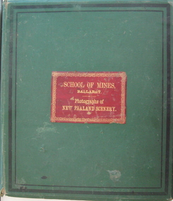
Book - Photo album, Photographs of New Zealand Scenery, 1886, 1886 (exact)
Before Mt Tarawera erupted, the Pink and White Terraces at Lake Rotomahana in New Zealand’s North Island, were considered one of the wonders of the world. Tourists came to soak in the thermal hot pools and view the marble-like terraces. Due to a volcanic eruption of Mt Tarawera On June 10 1886, between 108-120 people were killed and several settlements were destroyed. It also destroyed the world-famous Pink and White Terraces. The terraces became a crater over 100 metres deep. Within 15 years it filled with water, forming a much larger new Lake Rotomahana. The chain of craters at Waimangu became the site of many new geothermal features, including Waimangu Geyser, the largest in the world, and New Zealand’s largest hot spring, Frying Pan Lake. The Burton brothers (photographers), Alfred Burton was born in 1834 in Leicester and died in 1914 in Dunedin. His brother Walter Burton was born in 1836 and died in 1880. Many of the Burton Brothers' works and original equipment were collected by Dunedin photographer and historian Hardwicke Knight, and are now housed in the Museum of New Zealand Te Papa Tongarewa in Wellington. This album was donated to the Ballarat School of Mines Museum by James Oddie in 1887. (See Cat. No. 458, No. 1720) Alfred Burton was born in 1834 at Leicester and died at Dunedun, New Zealand, in 1914. Walter Burton was born in 1836, and died in 1889. Large green album containing numerous B/W original photographs of New Zealand, especially volcanos. - Includes Pink and White Terraces (no longer in existance). Photos were taken before and after volcanic eruption. A recent inclusion is article on the terraces by Federation University's George Hook and Stephen Carey.Each photo has a caption.pink terrace, white terrace, new zealand, sumner, burton bros, rotokakahi wairoa, rotomahana crater, tikitapu bush, wanganui bridge, maori, canoe, volcano, mount tarawara, james oddie, ballarat school of mines museum, eruption, waterfall, bridge, sulphur pool, crater, mt tarawera, tikitapu lake, rananga house, wairoa, waikato, maori church wairoa, ganaru, taherepokiore, golden bay, paterson, dowling st dunedin, rocky hill, harison's cove, milford sound, tall ship, hydraulic mining, hale's arm, james oddie (donor), george hook, stephen carey, lake rotomahana -
 Flagstaff Hill Maritime Museum and Village
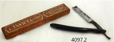
Functional object - Razor and case, E.M. Dickinson, 1895-1930
E M Dickinson was a cutlery company in Sheffield that made all types of cutlery knives of all types and patterns, razors domestic electroplated cutlery etc. Edwin Murray Dickinson started recruiting workers for his new cutlery firm at 11 Cambridge Street Sheffield England in 1870. The original premises consisting of warehouse, offices, cutlers shops fitted with the latest steam-powered equipment however this premises was offered for let in November 1887, and new premises were secured at 51 Division Street and were occupied by Dickinson's in early 1888. By October 1890 Dickinson was advertising the Division Street premises to let and moved the company into other new works (still called Murray Works) at 122 Rockingham Street. On 12th October 1901, Dickinson gave notice that the firm was to be converted to a limited company and by March 1908 the Rockingham Street works had been advertised for sale. In 1909 the deeds for other new premises at 203 Arundel Street Sheffield were deposited to secure a £3,000 loan from the Sheffield Banking Company. Then on Christmas Eve 1926 several hundred pounds worth of damage was caused by a fire at the Arundel Street works. The founder, Edwin Dickinson died on 21st October 1930 aged 81 at his home at 449 Crookesmoor Road and on the 23rd May 1939 the firm went into voluntary liquidation.An item made by a company that made many different types and patterns of cutlery for domestic use and export.Straight razor with black celluloid handle and it’s boxBlade has marking, INVICTA" with decorative engraved design, on the other side engraved "E M DICKINSON SHEFFIELD ENGLAND"flagstaff hill, warrnambool, flagstaff-hill, flagstaff-hill-maritime-museum, shipwreck-coast, flagstaff-hill-maritime-village, razor, e m dickinson ltd, e m dickinson ltd sheffield england., cut throat razor, cutlery -
 Orbost & District Historical Society
black and white photograph, C1910
the Orbost State School opened on19th of March 1886. The school had first operated temporarily in a leased building, and on a half-time basis with SS2745 Jarrahmond, The head teacher was Campbell Mackay who remained in charge only until 12th of May 1886. The second head teacher, John Rowe, served until 1908. On 30th of June 1887, a portable room was provided; it being brought to the area by schooner. The school now had accommodation for 30 pupils; the teacher's welfare was considered because quarters of two rooms were attached. As the population increased so did the needs of the school. This was reflected in the provision of a larger classroom in 1898. During 1910-11 the first approaches were made to the Department for the establishment of a Higher Elementary School in Orbost and this became a reality in 1912. Orbost. The Higher Elementary School supplied post-primary education in the district until a high school was built in 1948. When fire destroyed the school in 1941 local halls were used as classrooms until a new school was built, opened by the Hon. A. E. Lind, MLA, on 13th of February 1942. But Orbost continued to develop and the new school was soon overtaxed. This resulted in the erection of two Bristol classrooms in 1947. By 1950, when the school population had reached 500 pupils the opening of the new school at Orbost North was welcomed by all concerned. In 1963 the Department purchased land diagonally opposite the school and developed it as a playing area.This item is associated with education in the Orbost district.A black / white photograph of a large school building with two men standing out the front.orbost-state-school education-orbost -
 The Beechworth Burke Museum
Photograph
This photograph dates to 1899, towards the end of the gold rush in the Mopoke Gully area. A large opening to a mine can be seen behind the men in the photograph, with a wheeled cart on a track leading to the men's position, where the soil and rocks have been hauled away. This photograph interestingly contains dogs alongside the miners. While dogs have been recorded as deterrents to thieves in the Victorian goldfields, these dogs appear as companions to these men. Mopoke Gully mines came under the 'Fryer's Creek' division of the Castlemaine District during the Gold Rush. After the Gold Rush began in Victoria with the discovery of gold at Ballarat in 1851, Gold was found in Castlemaine by December of that year. 20,000 diggers were spread across the Castlemaine region, and the area was yielding about 23,000 ounces of gold per week. Mopoke Gully was the site of the Mopoke Gully Water Wheel, operating under the Bendigo and Fryers Goldmining Company from 1887 until 1900. This Water Wheel was used in the gold mining technique of 'sluicing'. Hydraulic sluicing uses high pressure water jets to blast away the earth, which runs through a sluice box, catching the gold with all remaining slurry washing away. This Water Wheel was built the same year as the more famous 'Chewton Water Wheel', but was smaller in diameter (60ft as opposed to Chewton's 72ft). The Mopoke Water Wheel ruins are quite intact today, and are a registered archaeological site. The search for gold is ingrained into the history of Victoria and therefore, images like this one can reveal important information for society and technology for the date when the photograph was taken. This image is of important historical significance for its ability to convey information about sluicing and the methods used to find gold in 1899. This photograph reveals important information on the use of dogs on Victorian goldfields in 1899. Dogs were used both as companions, such as this photograph depicts, as well as deterrents to thieves. Sepia coloured rectangular photograph printed on gloss photographic paper mounted on card. Obverse: Williams/ Good/ Luck Reverse: A02498/ 1997. 2498/ Good Luck/ Mine/ 1899/ Mopoke. beechworth, burke museum, gold, gold mining, 1899, castlemaine, mopoke gully, good luck mine, fryer's creek, gold rush, victorian gold rush, water wheel, sluicing, chewton -
 The Beechworth Burke Museum
Photograph, c1999
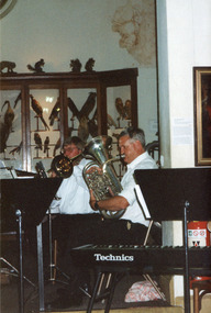
This photograph depicts two members of the Beechworth Band at a 'Liedertafel' concert in the main hall at the Burke Museum in 1999. The concert related to an exhibition titled, 'From the Liedertafel to the Skating Rink: Entertainment in Beechworth 1852 - early 1900s', which celebrated the rich and diverse entertainments that were a part of Beechworth life in the nineteenth and early twentieth centuries. 'Liedertafel' is a German tradition that accompanied European settlers to Australia. It refers to a friendly society of men united by an enthusiasm for singing. The Beechworth Liedertafel was established 14 March 1894 at the London Tavern, Camp Street, Beechworth, by president, Mr. A.A. Billson, and a visiting conductor, Mr. H. Fielder. The Beechworth Brass Band was formed by Mr. H. Vandenberg in 1887. Marching bands, choirs, processions, circus acts, theatrical performances, races, fancy dress and roller skating carnivals, were among the vibrant and diverse entertainments offered in Beechworth during the gold rush period. Race meetings were revived with a gala atmosphere at Baarmutha on New Year's Day and Easter Monday in the early 1880s. 'Spiller's Skating Rink', which premiered at St. Georges Hall in August 1869, was accompanied by the 'Beechworth Fire and Drum band'. In 1888, Beechworth had two skating rinks in operation, the Columbia Elite at Oddfellow's Hall, and the Beechworth Skating Rink, corner Camp and Last Streets, Beechworth. Vandenberg's Beechworth Brass Band was reported to have provided musical entertainment for patrons at both venues.This photograph of the Beechworth Band playing at the Burke Museum is historically significant for the information it conveys about an exhibition at the Burke Museum between September and November 1999. The use of the contemporary Beechworth Band in a 'Liedertafel' performance provides insight into curatorial approaches at the turn of the twenty-first century and improves our understanding of how exhibitions use objects in the Burke Museum's Collection to tell stories about the past in the present. The story of Liedertafel's and Beechworth Brass Band is historically and socially significant for understanding the role played by German immigrants in building Victorian communities. In settler communities, cultural associations centred on artistic, recreational and sporting activities not only provided a popular means of entertainment, but fostered social cohesion among settlers from diverse ethnic backgrounds.Rectangular colour photograph printed on matte photographic paper. Obverse (On keyboard): Technics / Reverse: 7028 / Label: Liedertafel / exh. / Beechworth / Band / 1999/2000 /liedertafel, beechworth band, burke museum, from the liedertafel to the skating rink, entertainment in beechworth 1852 - early 1900s, gold rush, immigration, beechworth's german heritage, london tavern beechworth, beechworth's first brick tavern, spiller's skating rink, vandenberg's beechworth brass band, protestantism, teetotallism, skating carnivals, beechworth german association, yma's, beechworth skating rink, progress societies, billson's brewery, german-australians, roller skating history -
 Brighton Historical Society
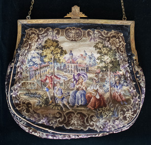
Bag, Evening purse, circa 1930
This bag belonged to by Mrs Alice "May" Moss CBE (1869-1948), Australian suffragist, social welfare campaigner and longtime resident of 59 North Road, Brighton. Born Alice Frances Mabel Wilson in Ballarat, in 1887 May married Isidore Moss, the son of Norwood's builder Mark Moss. While her children were young, she began to campaign for the rights of women and served as vice-president of the Australian Women's National League in 1906-14, during which time she actively campaigned in Victoria for women's suffrage. She was an Australian delegate at the League of Nations Assembly at Geneva in 1927, where she was the first woman to sit on a finance committee. She attended the International Council of Women in Geneva in the same year and in 1928 was elected as vice president of the ICW, a position she held until her death. She was the first president of the National Council of Women of Australia, serving from 1931 to 1936. May was active in many other community organisations and causes, including the Royal Women's Hospital, the Collingwood Crèche and the Free Kindergarten movement. She served on the board of management of the City Newsboys' Society in 1906-48 and was the first woman lay-member of the National Health and Medical Research Council in 1936-45. She was also member of the International and Lyceum clubs, with an interest in the theatre, painting and woodcarving.French petit point tapestry bag featuring seven people in a bucolic scene, with trees and buildings in the background. Black border. Gold metal hinged opening with ornamental clasp and gold chain.may moss, petit point, 1930s -
 Surrey Hills Historical Society Collection
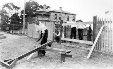
Photograph, St George's Church of England, Mont Albert working bee, early 1923 (2), 1923
The foundation stone for St George's Church of England, Mont Albert was laid in 1886 on land donated by Edward Dyer and the first service was preached in January 1887. From 1904 until 1907 it was known as Holy Trinity, Surrey Hills. The original church was weatherboard and replaced by a brick one in the Gothic Revival style which was designed by local architect George J V Blackburne, who also designed the Wesleyan School at Surrey Hills. The building was partly funded by donations, profits from a bazaar and concert, and other people donated furnishings. The church had boundaries along Mont Albert Road and St Georges Road. In 1998 the Church was sold and converted into a complex of units. Its current address is 19 St Georges Avenue, Mont Albert. The purpose of this working bee in 1923 was to close up the double gateway, which in earlier times had been used for entry of by horse-drawn vehicles to the church grounds. 'Lugano' was built in 1893 for William Wilson, a prominent stonemason and importer of marble fireplaces. In 1903 it became the home of William Holmes who was Chief Electrical Engineer for the Victorian Railways. He designed the electrification of the Melbourne suburban network. 'Lugano' stayed in the Holmes family until the 1930s. Norman Carter took many photos of Surrey Hills and Mont Albert from the 1920s in particular of events and activities associated with the Church of England.Black and white photo of 6 men behind and in front of a picket fence, a section of which has posts and railings only. In front of the fence is a wide grassy verge on which a bench is set up for cutting lengths of wood. A large Victorian house ('Lugano') can be seen in the background and a lamp post with a street sign. Beyond the house are mature eucalyptus trees.churches, holy trinity church, anglican church, st george's anglican church, working bees, lugano, william holmes, william wilson, norman brodley carter -
 Orbost & District Historical Society
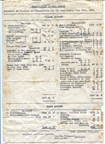
account, 30th June 1891
The first Presbyterian Church service was conducted at the Orbost Station Homestead in 1885, during a visit by Sir William Clarke, who was accompanied by two ministers. The organist was resident Grace Jennings Carmichael. Services were later held in Mr J. W. Borland’s shop and the Mechanics Hall. In 1887 the land on which the church now stands was purchased from Mr James Hossack snr, for £50 ($100). The trustees were Mr John, Peter and Hugh Cameron, Mr John A Watt and Mr James Hossack Jnr. Timber from Richardson’s Tabbara Mill was used by builder Mr R. P Cameron and at a cost of £ 311.3.7 ($622) the church was opened January 9th 1898. This item is from the estate of Elsie Cooke. Elsie Cooke was a librarian in Orbost for many years. She was the daughter of John Cooke early Brodribb settler. Elsie Cooke lived all her life in Gippsland,. She was born at Brodribb in 1895 and died in 1970, Elsie Cooke lived at Bruthen for a short time and, in 1937, moved to live with her aunt, Miss Jean Munro. Miss Cooke was Librarian at the Mechanics Institute for many years. Kindness and consideration for other were Miss Cooke’s attributes and she endeared herself to all who knew her. She was a loyal member of the Presbyterian Church and a stalwart of the Ladies’ Guild, an energetic worker for the Municipal Auxiliary and a member of the Red Cross. (ref. Mary Gilbert This item is associated with the Presbyterian Church in Orbost. It is an example of early book-keeping and is also associated with Elsie Cooke.Two white paper accounts. They are typed in black and are statements of receipts and expenditure for the Presbyterian Church in Orbost. On one sheet is an alhabetical list of subscribers for the year ending June 30, 1891. On the other is a general account of receipts and expenditure.presbyterian-church-orbost account-book-keeping -
 Wodonga & District Historical Society Inc
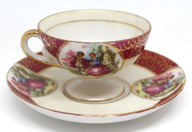
Domestic object - Small tea cup and Saucer, c1921
This item is from a collection donated by descendants of John Francis Turner of Wodonga. Mr. Turner was born on 6 June 1885. He completed all of his schooling at Scotts Boarding School in Albury, New South Wales. On leaving school, he was employed at Dalgety’s, Albury as an auctioneer. In 1924 John was promoted to Manager of the Wodonga Branch of Dalgety’s. On 15/03/1900 he married Beatrice Neal (born 7/12/1887 and died 7/2/1953) from Collingwood, Victoria. They had 4 daughters – Francis (Nancy), Heather, Jessie and Mary. In 1920, the family moved From Albury to Wodonga, purchasing their family home “Locherbie” at 169 High Street, Wodonga. "Locherbie" still stands in Wodonga in 2022. The collection contains items used by the Turner family during their life in Wodonga. The designation "Nippon porcelain" refers to porcelain made in Japan for export to the west, and stamped with the word Nippon on their bases. This practice began in 1891 in response to the U.S. McKinley Tariff Act, which forbade the import of items that weren't "plainly marked, stamped, branded, or labelled in legible English words." Unfortunately, many reproduction or fake pieces were also produced. In 1921 "Nippon" was no longer accepted by U.S. Customs Agents as the correct name of origin so from then on, imported Japanese porcelain was supposed to be marked "Japan". This information helps us to establish provenance of this item as after 1921.This item comes from a collection used by a prominent citizen of Wodonga. It is also an excellent example of Japanese porcelain of the early 20th century.A small teacup and saucer with a design of a couple in a garden. The design is repeated on the saucer. There is a circular pattern in red and gold around top of the cup and the rim of the saucer. Gilt decorations are included on the handle and around the inside of the cup.Under the saucer: Maker's mark inside a triangular shape and below a crown: "FINE CHINA/ Royal Nippon/ MADE IN JAPAN"domestic items, chinaware -
 Wodonga & District Historical Society Inc
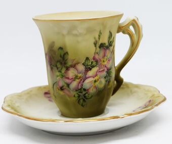
Domestic object - Hand painted coffee cup and saucer, c1920
This item is from a collection donated by descendants of John Francis Turner of Wodonga. Mr. Turner was born on 6 June 1885. He completed all of his schooling at Scotts Boarding School in Albury, New South Wales. On leaving school, he was employed at Dalgety’s, Albury as an auctioneer. In 1924 John was promoted to Manager of the Wodonga Branch of Dalgety’s. On 15/03/1900 he married Beatrice Neal (born 7/12/1887 and died 7/2/1953) from Collingwood, Victoria. They had 4 daughters – Francis (Nancy), Heather, Jessie and Mary. In 1920, the family moved From Albury to Wodonga, purchasing their family home “Locherbie” at 169 High Street, Wodonga. "Locherbie" still stands in Wodonga in 2022. The collection contains items used by the Turner family during their life in Wodonga. The designation "Nippon porcelain" refers to porcelain made in Japan for export to the west, and stamped with the word Nippon on their bases. This practice began in 1891 in response to the U.S. McKinley Tariff Act, which forbade the import of items that weren't "plainly marked, stamped, branded, or labelled in legible English words." Unfortunately, many reproduction or fake pieces were also produced. In 1921 "Nippon" was no longer accepted by U.S. Customs Agents as the correct name of origin so from then on, imported Japanese porcelain was supposed to be marked "Japan". This information helps us to establish provenance of this item.This item comes from a collection used by a prominent citizen of Wodonga. It is also an excellent example of Japanese porcelain of the early 20th century.A hand painted coffee cup and saucer with gold trim and floral design. The image includes tones of green shading and pink flowers.The cup and saucer have a gold trim. There are also embossed flowers on the saucer.Under saucer- Backmark - An hourglass surrounded by an upside down laurel wreath. Above the laurel wreath; "Hand Painted" Beneath the laurel wreath "NIPPON"domestic items, japanese porcelain