Showing 32033 items
matching buildings
-
 Stawell Historical Society Inc
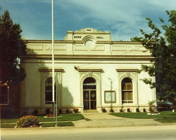
Photograph, Stawell Shire Hall 1866 c1980s -- Coloured
Colour Photo Stawell Shire Hall built 1866, c1980. The Shire Hall is in Longfield Street Stawell and has had many changes since 1866. Ronald Campbell, the Shire's second president laid the foundation of the hall on 28th April 1866. The contractors were Hutchings and Delbridge. The first Hall and office were the front part of the existing building. These rooms consisted of two 18 ft square rooms with an entrance hall separating them. The facade was almost the same as it is today. The building cost 502 pounds.Colour photograph of Stawell Shire Hall 1866. Very similar view to 0084 the photo clearly showing the two windows and arched entrance door. Landscaping outside the building is exactly the same as in 0084. stawell -
 Buninyong & District Historical Society
Photograph - B/W photograph, St. Alban's Cottage c 1873, former home of Dr. Sparling, July 1993
Built around 1873 by Dr. Sparling, on land formerly occupied by the first Buninyong Inn (aka Jamieson's Hotel). Some materials from the demolished hotel may have been used in building the house.Good example of 1870's professional residence, links to prominent citizen Dr Sparling.B/W Photograph, Polychrome brick cottage, L-fronted with bullnose verandah, on bluestone foundations with low bluestone fence. Signs "Buninyong Antiques" (under verandah) and "Antiques" on front of building.buninyong, sparling, jamieson, house, brick -
 Federation University Historical Collection
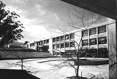
Photograph - Photograph - Colour, Ballarat College of Advanced Education Science Building
The black and White buildings of 'S' Building on the Mount Helen Campus of Federation University Australia. One photo shows 'D' Building under construction.ballarat college of advanced education, mount helen, greenhill, s building, d building, science building, courtyard, pound, britalism -
 Eltham District Historical Society Inc
Photograph, Eltham Community Centre
... buildings ...Australia’s first mud brick community building was opened in 1978. In 2018 a major upgrade took place. Colour photograph of mud brick Eltham Community Centre at corner of Main Road and Pitt Streeteltham, community centre, buildings, mud brick, main road, pitt street, eltham community reception centre -
 Sunbury Family History and Heritage Society Inc.
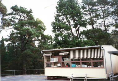
Photograph, Bulla Primary School - Portable classroom, c1990s
The building was one of the classrooms brought to the Bulla Primary School in the early 1990s to accommodate the increased school enrolments. These rooms were easily transportable and were uses extensively in Victorian Government schools from the early 1950s onwards to cope with growing school attendances. A non-digital photograph of a weatherboard building with a low pitched metal roof and brown and white striped sun-blinds erected in an open ground with tall conifer trees in the background.bulla primary school, portable classrooms -
 Mission to Seafarers Victoria
Slide - Glass slide, Black and white, circa 1921
This image provides an additional later modified building view to that of the image of the original single storey building image published on back page of the 1910 MTS Annual Report. According to the Annual Report of 1915 the plans to build a residence on top ( the 2nd storey ) of the Port Melbourne building got the go ahead to commence and opened 1916. Originally designed by architect, Frederick Williams, who built the first brick Mission at Port Melbourne in the 19th C. Walter Butler was commissioned for the second storey.The Port Melbourne building in the image established in the 19th C., still survives. It was a key centre of operations for the Mission prior to the building of the Mission near Australian Wharf in 1907 and prior to the eventual opening of the current "Central Mission" in 1917. NB operations of The Port Melbourne Branch Mission were eventually transferred to the King George V memorial Building, dedicated in December 1937 but demolished in 1995. The Mission depicted here still survives as part of an apartment complex on the corner of Nott st.Positive photograph on medium format glass slide ; b & w image of brick building taken from a corner street level view, with upper storey at one end on glass transparency with a flagpole and flag (Flying Angel) just discernible. The slide is edged with adhesive tape.missions to seamen institute, mission building, frederick williams, walter butler, port melbourne, beach road, mission to seafarers, nott street -
 Federation University Historical Collection
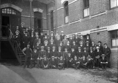
Photograph - Photograph (Black & White), Ballarat School of Mines Students, c1907
This building was built at the Ballarat School of Mines, now a campus of Federation University Australia.A black and white photograph mounted onto dark card showing a group of Ballarat School of Mines students and staff posing around the stairs at the back of the New Classrooms (now known as the Administration Building) . Professor Alfred Mica Smith sits in the second front row Verso: Group of Ball. Sch. Mines Students 25.10.07 ballarat school of mines, students, alumni, alfred mica smith, class, administration building, a building -
 Federation University Historical Collection
Photograph, Trav Munro, Federation University Arts Academy, 2016
Colour photograph of buildings at Camp Street Ballarat, including the Post Office building.arts academy, camp street, post office gallery, former ballarat post office -
 Bendigo Historical Society Inc.
Slide - BENDIGO BUILDINGS, Jan 1970
Slide. Bendigo Buildings. A three storey building under construction by Leighton Constructions.slide, bendigo, bendigo buildings., bendigo buildings. -
 Bendigo Historical Society Inc.
Slide - BENDIGO BUILDINGS, 1961
Slide. Bendigo Buildings. Building on edge of old brickworks, Miller Street Bendigo.slide, bendigo, bendigo buildings., bendigo buildings. -
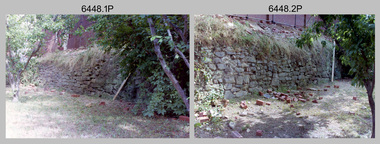
 University of Melbourne, Burnley Campus Archives
Photograph - Black and white print, Garden View, Unknown
Black and white photograph. Gardens to the South East of the Administration Building with the building in the background.On reverse, "Burnley Gardens with Burnley Horticultural College in the Background." "A."administration building, garden view, main building, emily gibson beds -
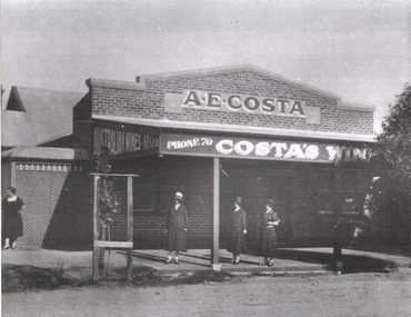 Wodonga & District Historical Society Inc
Photograph - A. E. Costa's Wine Shop
Costa’s Wine Cafe was once one of the best known landmarks in Wodonga. It was near the corner of High Street and Lawrence, across the road from where the water tower was later built. Mr. Bernardo Costa came to Australia from Switzerland, arriving in Sydney in 1857. In 1882 he moved to Wodonga and conducted his boot sale and repair business He applied for a Wine License in December 1886. In 1908 B Costa advertised that he had rebuilt his premises, which “affords the best and most comfortable accommodation to the travelling public”. For a while it was known as Wodonga Swiss Wine Café. After Bernardo’s death in 1915 the wine cafe and accommodation at the rear was run by his three daughters, Annie, Angela and Gertrude. In 1941 the Misses Costa sold their business and freehold to Mrs. J Adams who died just six years later. It was then run by her son Pat Adams, and after his demise his wife ran the business. Frank Walsh was running it as Walsh’s Wine Café by 1951. The Wine Café was closed in 1963 having been purchased by Woolworths and was demolished to build their new supermarket on the site.These images represent an early business in Wodonga . 2 black and white photos of the buildings of A. E. Costa, a brick building with signage.Photo 1: Above verandah: A.E. COSTA / Phone 70 COSTA's WINE Photo 2: Above verandah : WINE CAFEwodonga businesses, a. e. costa, wodonga pioneers, early wodonga businesses, wodonga businesses high street -
 Stawell Historical Society Inc
Photograph, “Warranooke” Homestead in Glenorchy 1867
“Warranooke” Homestead built 1867 enlarged 1926 destroyed by fire 13th Feb. 1979. Black and white photograph of a single storey building with a two storey building behind.glenorchy -
 Clunes Museum
Photograph - PHOTOGRAPHS
.1 The netball court in the photo was where "Collins Place", Fraser Street, Clunes is now located .3 the warehouse/Clunes Museum building at 36 Fraser Street, Clunes, was a former freezing worksPhotocopies of photographs .1 2 copies of girls playing netball .2 A streetscape of Fraser Street, Clunes .3 Del Mayberry (nee Campbell) and friend. The building that is now the warehouse/Clunes Museum is in the background of this photo, the building was a former freezing works .4 Jean Harling (nee Campbell) and male friend, outside The Club Hotel, Fraser Street, Clunes .5 Landscape of Clunes looking towards Station Flat Road. Port Phillip Mine is in the backgroundcampbell, netball, mayberry, harling -
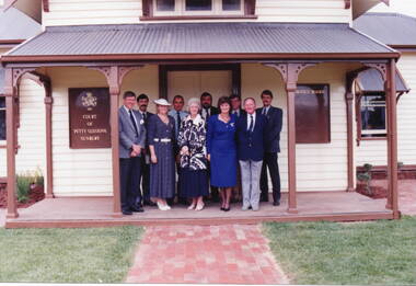 Sunbury Family History and Heritage Society Inc.
Photograph, Sunbury Courthouse, 1993
The group in the photograph at the opening of the former Sunbury Courthouse. The Courthouse was built in 1885 and functioned in that capacity until 1989 when it closed. In the 1992, Shire of Bulla council began to restore the building, which was completed in 1993. It functioned as a Tourist Information Centre until 2019, when that service was transferred into the new Global Learning Centre in Sunbury. The building is now occupied by the local Sunbury Aboriginal Corporation. Invited guests at the opening of the restoration in 1993 were from L- R: Back- Phil McMahon, Mayor, Sgt. Doug. McArthur, Sunbury police, John Munns, John Barnier, Jeff Cossum, Museum curator. L-R: Front - Peter Free, Cr. Kathy Duncan, Joy Munns and Cr. Veronica Burgess.The former Sunbury Courthouse was an important official building serving Sunbury and the surrounding area for over half a century. A non-digital coloured photograph of nine people at an official function are standing on the verandah of a weatherboard building. There is a timber notice board attached to the wall on either side of the group. phil mcmahon, doug. mcarthur, john munns, john barnier, jeff cossum, peter free, kathy duncan, joy munns, veronica burgess, sunbury courthouse, sunbury -
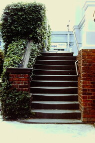 Kew Historical Society Inc
Slide - Stairs: Kew Post Office, 1980
A civic campaign for new public offices developed in Kew in the 1880s. After much deliberation, the location chosen was the junction of Bulleen and Cotham Roads. The buildings were designed by George Watson and John Henry Harvey, architects within the Department of Public Works (Victoria). Building was commenced in 1887, and after one year, the buildings were opened. The Post Office was transferred to the new Commonwealth Government in 1901. The Police Station and Court House, sold by the Victorian Government to the City of Boroondara in 2007, are now a community cultural centre and performing arts venue.The buildings were listed on the Victorian Heritage Register Register (HO885) in 1991. They are historically and architecturally significant to the State of Victoria because Watson and Harvey's designs exhibit diversity in integrating civil offices, they accommodate the apex of road junctions, and they demonstrate a departure from the contemporaneously favoured High Victorian Classical to the Queen Anne style in the design of civic buildings. 35mm colour transparency of the stairs on the right side of the entrance to the Kew Post Office. The [former] post office is a significant example of the English Queen Anne Revival style. The photograph was taken as part of a series by Ralph Andrews (Department of Building, RMIT) in April 1980.kew post office, khs - slides, new public offices -- kew (vic.), architectural styles -- english queen anne revival -
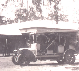 Lakes Entrance Historical Society
Photograph - Whadcoats Mail Bus Service, 1920 c
Tall trees behind building possibly outside store or hotel at Nowa Nowa Victoria Inscriptions and markings Black and white photograph of C Whadcoats Mail Bus it has three rows of seats, open sides and solid roof very wide front mudguard. Tall trees behind building possibly outside store or hotel at Nowa Nowa Victoriatransport, postal services -
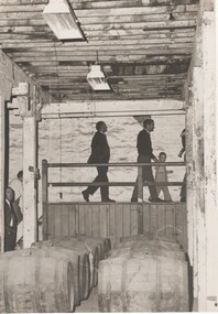 Rutherglen Historical Society
Image, Olive Codling
Some of the buildings of the Mount Ophir winery. Photo was taken by Miss Olive Codling, who was a life member of the Wodonga Historical Society. Photograph is believed to have been taken on the occasion of a Tour by the North East Branch, 1st combined meeting.Black and white photograph of several people walking across a raised walkway in a building with rough textured walls, and stained timber ceiling beams. There are two rows of wine barrels in the foregroundmt ophir, mount ophir, wine industry -
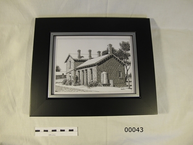 Yendon History Group
Framed pen and ink sketch of Yendon station, Mervyn Hill, 2010
Sketch was done as a sample of the artist's work when a drawing was sought to be the picture of the station on the interpretive sign planted at Yendon station. Although this is an excellent interpretation of the station building, it was thought to be too detailed for the purpose.Pen and ink detailed drawing of Yendon station building, with 2 people standing on the platform. Frame is timber, 50mm wide, mat black, with an 8mm silver trim around the cut-out hole.Signed by Mervyn Hill at the bottom right hand corner.yendon railway station, hill, mervyn, ink drawing -
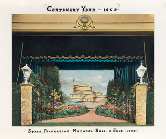 Bayside Gallery - Bayside City Council Art & Heritage Collection
Photograph - hand-coloured photograph, Brighton Centenary Year, Stage decoration, Mayoral Ball, c. 1959
This work was presented to The Mayor and Mayoress, Cr. and Mrs R.G. Ward, by the citizens of Brighton to commemorate the Brighton Centenary in 1959. Brighton was first incorporated as a borough on 18 January 1859, it became a town on 18 March 1887 and was proclaimed a city on 12 March 1919. The new Brighton Municipal Offices were designed by Kevin Knight of Oakley and Parkes with the engineers John Connell and Associates and were erected by Prentice Builders Pty Ltd. The foundation stone was laid on 13 February 1959 and the building was opened on 21 July 1961. The interior decoration and furniture was by Grant Featherston.brighton centenary, brighton town hall, stage decoration, mayoral ball, brighton municipal offices, civic centre, oakley and parkes, kevin knight, r.g. ward, mayor -
 Stawell Historical Society Inc
Photograph, Stawell Shire Hall -- Coloured
Stawell Shire Hall photograph taken around the same time as 84.13. Image shows the building painted white with no decorative fence out the front.View from the street of Stawell Shire Hall. The image is taken from the right hand side of the building showing a colourful flower bed in front of a large tree. The flag post is also out the front of the Shire Hall. stawell -
 Stawell Historical Society Inc
Photograph, Stawell Shire Hall 1866 c1990's
Stawell Shire Hall photograph taken late 1990s. The building appears freshly painted with the flag pole on the left hand side. The front door is now glass.Black & white photograph of Stawell Shire Hall late 1990's. The flag pole is on left side and the building looks freshly painted. The front door is now glass. Photo in Album 7 page 53.stawell -
 Bendigo Military Museum
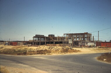
Photograph - New Printing Building Construction, Lithographic Squadron - Army Survey Regiment, Fortuna, Bendigo, c1989
This is a set of 12 photographs of contractors constructing Lithographic Squadron’s new Printing Building at Fortuna, Bendigo circa 1989. The building was purpose built to house a new computer-controlled Heidelberg Speedmaster five colour lithographic offset Printing Press. The print room was named Wayzgoose Hall after a medieval printing house festival. Wayzgoose Hall and the Speedmaster Press printing capability was commissioned by the Commander of the 3rd Military District BRIG P. Davies AM, ADC on Wednesday 27th June 1990. This occasion is covered in more detail in page 145 of Valerie Lovejoy’s book 'Mapmakers of Fortuna – A history of the Army Survey Regiment’ ISBN: 0-646-42120-4. See items 6131.18P and 6444.16P for photos of earlier phases of the construction process.This is a set of 12 photograph of the construction of Lithographic Squadron’s new Printing Building, Army Survey Regiment at Fortuna, Bendigo, c1989. Colour photographs are on 35mm negative film and scanned at 96 dpi. They are part of the Army Survey Regiment’s Collection. .1) to .2) - Photo, colour, 1989. Old stone retaining wall .3) to .12) - Photo, colour, 1989. Construction of new printing building.No personnel are identified. royal australian survey corps, rasvy, army survey regiment, army svy regt, fortuna, asr, litho sqn, printing -
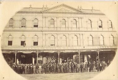 Bendigo Historical Society Inc.
Photograph - OLIVE PELL COLLECTION: GROUP PHOTO OF MEN
... BUILDINGS ...Photograph, on cream photo paper with picture within an oval shape of the name James Buick & Co Bee Hive Stores Building sign written across the verandah. The building has an ornate roof with six decorative finials in the shape of urn's along a balustrade. In the center is a triangle with a coat of arms. Lace work runs along the rood line. There are eighteen curved windows three have advertising for the Bee Hive Billiard Saloon, left to right one for H. Birch Legal Manager and General acent? and Globe Insurance Company. The fifth one is C. W. Belt Legal Manager General Accountant. the last on the right reads Denson?. One Man is standing on the verandah next to the Saloon window. There are 60+ men in the photo all wearing hats, one girl and two dogs some standing on the road and others standing on the foot path. Three pin hole on the top of the photo.buildings, commercial, beehive stores, james buick & co bee-hive stores, bee-hive billard saloon. -
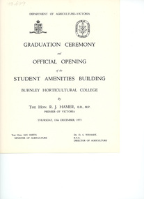 University of Melbourne, Burnley Campus Archives
Programme - Graduation Ceremony Program, Department of Agriculture, Victoria, Graduation Ceremony & Official Opening of the Student Amenities Building, 1973
The Student Amenities Building was officially opened by the Hon. R. J. Hamer, Premier of Victoria. Also present: Ian Smith, Minister for Agriculture and Dr. D. S. Wishart, Director of Agriculture.graduation ceremony, student amenities building, sketch, burnley horticultural college, the hon. r. j. hamer, ian smith premier of victoria, minister for agriculture, dr. d. s. wishart, director of agriculture, graduation ceremony programme -
 Halls Gap & Grampians Historical Society
Photograph - B/W, C 1875
... BUILDINGS ...1875-1876 The residence of John and Catherine D/Alton built on site of present Colonial Motor Inn. 1900 Owned by Langley family, "Morningside" was now taking in paying guests. 1909 Leased by James and Grace D'Alton who continued to run a small guest house. Late 1920s a small building was erected to serve as PO and telephone exchange. C1980 Guest house closed. 1982 Morningside demolished.Weatherboard house, picket fence 5 people Alexandria and Laura Sheridan, Catherine D/Alton, Meg Sheridan, a man standing at fenceMorningside 1875-76 John D'Alton and 2nd wife Catherine Fulton nee (Denholm), her mother and Aunt Mrs Sheridan original front now the back of Colonial motel Rose'e Australasian Views. Vitorian Series. Photographed and published George Rose, 123 Chapel St Windsor, Victoriabuildings, morningside, people, d'alton -
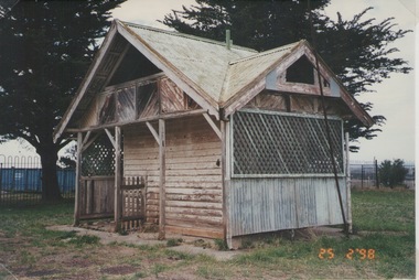 Sunbury Family History and Heritage Society Inc.
Photograph, Rosa McCall, Wooden Outhouse, 25th February 1998
The wooden outhouse was erected in the former Sunbury Asylum grounds and was a popular outdoor building where the patients and staff relaxed while walking around the grounds.Patients were encouraged to spend time outdoors and the extensive and elevated grounds provided plenty of space. The photograph was included in a collection that was put together for a photograph competition organised by the former Sunbury & District Heritage Association in March 2001.A non-digital coloured photograph of a wooden and corrugated iron outhouse with a trellis covering half of a wall. Two large cypress trees are behind the building.sunbury asylum, outbuildings, sunbury -
 Eltham District Historical Society Inc
Ledger, Eltham Road District. Assessment for the Year ending Oct. 14th, 1859, 1858c
The Eltham Roads Board was established in 1856. This ledger includes the signature of Road Board Secretary and Collector Wingrove, a significant person in Eltham's early history. This is a unique significant record of early settlers in the Shire of Eltham. One of 6 early rate books. This is among the oldest items in the EDHS collection. An article in the Eltham and Whittlesea Shires Advertiser Friday 21 Nov 1941 Page 5 titled: District's Early History states: "The first rate book which is still in existence at the Shire Office is for the year ending October 14, 1858 and is probably the best record possible to indicate the development of the district. At the time properties were rated as follows: Cultivated land. 6d. per acre; pasture land, 1d. per acre: estimated annual value of buildings, etc., 6d in the (pound). The total amount of rate recorded for the year was (pounds)153/14/8. Properties were described as being situated at Lower Plenty, Yarra Yarra, Eltham, Lower Eltham, Kangaroo Ground, Yarra Flats, Diamond Creek and the Yarra."Ledger with printed columns: Number, Name of Occupier, Description, Where situated, Cultivated land, Pasture land, Estimated annual value of buildings, Rate, Remarks, Arrears collected, excused, unoccupied, uncollected and amount actually collected. Ledger filled out by hand with 173 entries (not alphabetically arranged). A number of blank pages are included. Inside cover includes pasted printed note: RATE OF ASSESSMENT AS FOLLOWS: Cultivated land 6d per acre Pasture land 2d per acre Unalienated Pasture Land 8d per Acre Estimated Annual Value of Buildings, &c., 6d. in the Pound eltham roads board, rate book, rate payers, transaction, pioneers, settlers, wingrove, 1859, assessment ledger, eltham road district, public records office victoria (prov), rate books, shire of eltham archives -
 Eltham District Historical Society Inc
Ledger, Eltham Road District. Assessment for the Year ending Oct. 14th, 1860 (Version 1), 1859c
The Eltham Roads Board was established in 1856. This is a unique significant record of early settlers in the Shire of Eltham. One of 6 early rate books. This is among the oldest items in the EDHS collection. An article in the Eltham and Whittlesea Shires Advertiser Friday 21 Nov 1941 Page 5 titled: District's Early History states: "The first rate book which is still in existence at the Shire Office is for the year ending October 14, 1858 and is probably the best record possible to indicate the development of the district. At the time properties were rated as follows: Cultivated land. 6d. per acre; pasture land, 1d. per acre: estimated annual value of buildings, etc., 6d in the (pound). The total amount of rate recorded for the year was (pounds)153/14/8. Properties were described as being situated at Lower Plenty, Yarra Yarra, Eltham, Lower Eltham, Kangaroo Ground, Yarra Flats, Diamond Creek and the Yarra."Ledger with printed columns: Number, Name of Occupier, Description, Where situated, Cultivated land, Pasture land, Estimated annual value of buildings, Rate, Remarks, Arrears collected, excused, unoccupied, uncollected and amount actually collected. Ledger filled out by hand with 177 entries (not alphabetically arranged). A number of blank pages are included. Inside cover includes pasted printed note: RATE OF ASSESSMENT AS FOLLOWS: Cultivated land 6d per acre Pasture land 2d per acre Unalienated Pasture Land 8d per Acre Estimated Annual Value of Buildings, &c., 6d. in the Pound eltham roads board, rate book, rate payers, transaction, pioneers, settlers, wingrove, 1860, assessment ledger, eltham road district, public records office victoria (prov), rate books, shire of eltham archives -
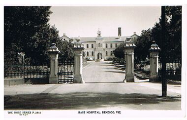 Bendigo Historical Society Inc.
Postcard - BENDIGO BASE HOSPITAL
... Buildings ...Postcard, black and white. Image shows front gates of Bendigo Base Hospital. Two storey building, gateway has two pillars each side. On bottom of card' The Rose Series P 2851 Base Hospital, Bendigo, Vic' On back ' Post Card, The Rose Series Deluxe.'Rose Seriesbendigo, buildings, bendigo base hospital, bendigo base hospital, hospital, barnard street, medical