Showing 2688 items matching "1871-1872"
-
 Orbost & District Historical Society
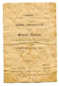
advertisement, 1902
Mrs Arthurena Dora Beattie (nee Morrison), had been teaching privately at Rosedale and came to Orbost with her husband and family in 1890. In 1892 she opened a private school in Salisbury Street (about the site of the Countryman Motor Inn) which she conducted for about 10 to 12 years. Her husband, John Wilson Beattie, a retired State School teacher, had been head teacher at the Rosedale School from July 1870 to August 1884. After coming to Orbost he selected land on Wall Creek. He was a widower with 7 of 11 surviving children when he married Arthurena in 1885. His fist wife, Georgina (nee KELLY) died at Rosedale in 1883 when the youngest child was just 5 weeks old. John and Arthurena had a further 8 children (5 born at Orbost), and after John's death she married George McCARLIE in 1916 at Sale and moved Mirboo North. (references:BEATTIE, Arthurena Dora Music teacher, Orbost - 1903 Electoral Roll. BEATTIE, Arthurena Dora Teacher, Orbost - 1912 Electoral Roll.) There was at least one other private school much earlier, in 1884. It was thought to be the first school in the district and conducted by William Ballantyne. It was located on the flat on the Newmerella side of the Snowy River near where the first railway crossing used to be. Wm Ballantyne had previously taught school at Sarsfield from June 1873 to November 1879. (information from John Phillips) This advertisement was for educational tuition by Mrs Beattie. Tuition would be from 10.00am - 12.00 and from 1.30pm - 3.30pm. Costs were thirteen shillings per quarter for children under the age of 12 years and one guinea for those over 12 years. A reduction would be given for more than one child in the same family. The 1872 legislation required all children aged 6-15 years to attend school unless they had a reasonable excuse. Parents who did not send their children to school were liable for fines up to five shillings for a first offence, with the penalty increasing to 20 shillings for each repeat offence. The Orbost State School had opened on 19th of March 1886 and this "private school" appears to have been a small private enterprise school. This is a useful research item associated with education in Orbost.A white A5 size paper advertisement which has black print. It is an advertisement for private educational tuition. Details of costs and hours are included.beattie education school advertising -
 Surrey Hills Historical Society Collection
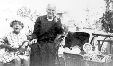
Photograph, Annie Barton and Jocelyn Cerini, 1928, c1928
The photo was taken in 1928 and the young child is definately Jocelyn Francesca Cerini, elder daughter of Natale Cerini and his wife Ethel (MS: Swan). The Cerini family lived at 215 Union Road. Most likely that the photo was taken in the back garden of 215 Union Road which backs onto 11 and 13 Barton Street. Thus the houses in the background are the two houses occupied by Barton family members - No 11 and 13 Barton Street, Surrey Hills. The photo card index compiled by Jocelyn Hall (nee Cerini) identifies the elderly lady as Miss Annie Barton, sister of Rev John Barton, second minister of Wyclif Congregational Church. She was a nurse. However the age of Jocelyn (born 1922) makes it more likely that this is Mrs Annie Eliza Barton (nee Duncan), wife of the Rev John Barton and mother of James Duncan Barton, John Saxon Barton, Ida Grace Barton, Albert Edward Barton, Annie Barton and Harold Arthur Barton. Annie Eliza (Duncan) Barton was born in 1845 and died on 16 Jan 1933, which is consistent with the age of the lady pictured. By the time this photo was taken her husband, the Rev John Barton (1844-1919) had died. He was minister of the Wyclif Church in 1896 and continued in that role until 1907. After a further appointment John Barton retired and continued to worship at Wyclif, residing at 13 Barton Street. On Federation in 1901 the street name changed - it was originally Kent Street. John Barton was born in 1845 in Ainsdale, Lancashire, son of James Barton and Ann Rimmer and grew up in Formby - the name later given to No 13 Barton Street. His family appear to have remained in the UK. He married Ann Eliza Duncan in 1872 in Queensland. Of the 2 daughters who were nurses: Ida Grace Barton (b 1877) did not marry. She trained at the Homeopathic Hospital (later Prince Henry's Hospital), graduating in 1909. Annie Barton (b 1883, Geelong) trained at the Melbourne Hospital. She was Matron AANS during WW1 in charge of the Base Hospital (Military) in St Kilda Road. She married Dr John Hodgson Nattrass. She died in 1965 at Caulfield. John and Ann Eliza Barton are buried in Box Hill Cemetery - C0044.A black & white photo of an elderly lady seated in a cane chair in an outdoor setting. To one side is a young girl also seated in a chair and holding a doll; to the other side is a doll's pram containing another doll. The background is indistinct but appear to be houses.clothing and dress, 1928, miss jocelyn francesca cerini, mrs jocelyn hall, annie eliza duncan, annie eliza barton, box hill cemetery, rev john barton, jocelyn cerini, dolls, 215 union road -
 Port Fairy Historical Society Museum and Archives
Photograph
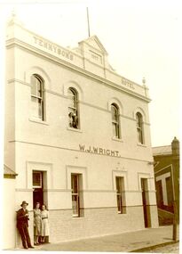
The small building on the left is the Farmers Inn, and was built about 1849, when James Brown became the first licensee. In 1854 John Walwyn Taylor moved from the Sally Ann to take over, and remained there until 1857, when he moved to his new hotel The Star of the West built on the old Sally Ann site. John Wall then became the new licensee of the Farmers Inn. In 1876 his wife Bridget made an application for the license to be transferred to her as “her husband suffered from rheumatism, and there were certain other reasons why the license should be transferred to her hands”. The Bench wondered about creating a precedence of granting a license to a married woman, who was living with her husband, (licenses were only granted to the widows of licensees at that time), so the application was postponed for 14 days, but eventually Mrs Wall won her case. In 1882 Patrick Tennyson took over the lease of the Farmer’s Inn and applied to change the name to Tennyson’s Hotel. In 1885 he bought the freehold in the Great Land Sale for £780. 12s. 8d., and in December, carried out extensive renovations. The local press reported that “the rooms were quite tasteful, the Billiard room commodious and well ventilated, and that the old hotel had not looked so good for years”. The double storied part of the hotel was added in 1893. Patrick Tennyson had a colourful career. He was born in Charlemont, County Armagh in 1846. When he was 21, he served as a papal guard at the Vatican for 2 years and then entered the Marist Brothers novitiate in Beauchamps. In 1872 he was one of three brothers to accompany Brother Ludovic to Sydney; he was then aged 23. After 5 years he withdrew from the Congregation and moved to Victoria, where he took up teaching, first at Rosedale near Sale, then at Crossley, by which time he was married to Anne White. They had eight children, three dying in infancy. Eight months after he took over the Farmers’ Inn, he was elected to the Borough Council, and served as Mayor in 1897. His great interest was sport, was Secretary of the Race Club for 20 years and supported the local Football Club by donating a silver cup for local competitions. Patrick Tennyson died in 1904. The hotel continued under various licensees until it burned down in 1977 under the name of “The Fishermen’s Arms”. Well known main street hotel no longer exists Sepia photograph of 2 story building with tiled wainscoting male and 2 females in doorway and 2 females in window upstairshotel, building, sackville street, patrick tennyson, w.j.wright -
 The Beechworth Burke Museum
Photograph - Photograph - Reproduction, c.1870s
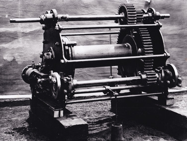
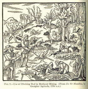
This photograph shows a piece of gold mining equipment identified as a mine winch, possibly an air winch cylinder of 1870s RG Ford's Patent design. Throughout the history of mining for gold and other precious materials, the windlass or winch (pictured) was used to bring up buckets full of soil from the bottom of a mine. This soil was then searched for gold/metals before being relocated to a different area. Due to the size and complexity of this particular piece of equipment, this winch may have been used to raise and lower mine carts to the entrance of the mine (often used in coal mining) and could have been used in raising cages up and down (acting as elevators) containing miners if the mine was particularly deep. The actual use of this particular item in the Beechworth locality is undocumented but these are some possibilities based on the use of these pieces of equipment in other mining locations. Mining can have a largely detrimental impact to the environment and therefore, the study of machinery like the one depicted in this photograph can help researches to reconstruct the methods and technologies used in the late 1800s and early 1900s. This particular item appears to have been removed from it's original site where it would have been used to assist with mining. It is possible that this photograph has been taken for recording purposes or as part of a machinery exhibition. Prior documentation records that this piece of equipment had connections to the Rocky Mountains Mining Company. Today, the Rocky Mountains Gold Mining company is famous in Beechworth for having been instrumental in the creation of the Rocky Mountain tunnel. Construction for this tunnel began in 1859 when a group of 12 men blasted a 400ft long tailrace though the rock beneath the town of Beechworth. Today, the 800ft tunnel, completed in 1871, is a popular tourist attraction but during the decades of gold mining, the purpose of this tunnel was to divert water away from the main sluicing operations so miners could better access gold and precious materials. The tunnel was used for this purpose for many years, later becoming useful for the Zwar Brother's tannery and currently as an outfall drain for Lake Sambell. This area continued to be mined until the early 1900s. The period when this item was in use is unclear but it is estimated to have been in the 1870s based on the design and appearance of the image. The gold works at the Rocky Mountain Tunnel closed in the early 1920s but the impact of mining remains in Beechworth today and therefore the study of photographs like this one which contain mining equipment can further understanding of mining in this region.This photograph has historic and research potential for study on the gold mining of the Beechworth region and types of equipment used to locate gold after the initial gold rush of 1853-1854 which resulted in the discovery of the surface gold and required miners to dig deeper to access precious metals. The clarity of the photo, and its good preserved condition, means it can continue to be used for research. This photo is part of a collection of six photos all within the Burke Museum Collection which depict mining equipment.Square black and white photograph on card.7793.1beechworth, mining, goldmining, goldmining equipment, beechworth burke museum -
 Eltham District Historical Society Inc
Photograph, Liz Pidgeon, Public Records Office Victoria (PROV) visit to Eltham Justice Precinct, 20 Apr 2018
The original Shire of Eltham was founded in 1871. Prior to its founding, the district was managed by the Eltham District Road Board, which was established in 1856. The initial rate assessment commenced in 1857 for the year ending October 14, 1858. The honour of being recorded with the first assessment went to a farm of 110 cultivated acres at Lower Plenty, owned by John Porter and occupied by Albert Baines. It was assessed at 6d/acre providing for a rate income of £2 15s. In July 2017, officers at Nillumbik Shire Council discovered some early Eltham Road District Assessment books and donated them to the Eltham District Historical Society. The seven volumes were the district’s first six years of rate assessments. This was a unique and significant record of early settlers in the pre-Shire of Eltham. They immediately became one of the oldest and most valuable items in our collection. An article on page 5 in the Eltham and Whittlesea Shires Advertiser, Friday, 21 November, 1941 titled: ‘District’s Early History‘ states: “The first rate book which is still in existence at the Shire Office is for the year ending October 14, 1858 and is probably the best record possible to indicate the development of the district. At the time properties were rated as follows: Cultivated land. 6d. per acre; pasture land, 1d. per acre: estimated annual value of buildings, etc., 6d in the (pound). The total amount of rate recorded for the year was £153/14/8. Properties were described as being situated at Lower Plenty, Yarra Yarra, Eltham, Lower Eltham, Kangaroo Ground, Yarra Flats, Diamond Creek and the Yarra.” Given the precious nature of this collection, priority was given to digitise the rate books and place them in suitable archival storage to minimise further handling. Subsequent discussion amongst our Collections team arrived at the conclusion that the most appropriate home for this valuable record was the Public Record Office Victoria (PROV), the archive of the State Government of Victoria and who are charged with archiving and caring for all Government related records. An approach was made to PROV who confirmed these records would complete their collection of rate assessment books for Eltham. At a small ceremony held Friday, April 20 at the Local History Centre, Eltham, members of the Society and our Collections team, along with Ms. Vicki Ward, MP for Eltham, presented the seven volumes for 1858-1863 along with the complete set of digital files to Mr. David Taylor, Community Archives Manager and Mr. Charlie Farrugia, Senior Collection Advisor, Public Record Office Victoria.Born Digitalassessment ledger, donation, eltham courthouse, eltham road district, local history centre, public records office victoria (prov), rate books, eltham district road board -
 Victorian Interpretive Projects Inc.
Book, Theodore Jesse Hoover, The Economics of Mining, 1938
Theodore Jesse Hoover, brother of the 31st President of the United States, was born in West Branch, Iowa, on January 28, 1871. He attended Stanford and received the Bachelor of Arts degree in Geology and Mining in 1901. Following graduation his professional career started with the position of assayer for the Keystone Consolidated Mining Company. After one year, he became assistant manager for the Standard Consolidated Mine, and a year later he was promoted to manager of the operation. In 1907 Hoover went to London as general manager of Minerals Separation, Ltd. This company was developing the froth flotation process for recovering minerals from ores. Hoover took an active part in the development of the flotation concentration process and authored one of the first books on the concentration of ores by flotation. After four years with Minerals Separation, Ltd., Hoover entered private practice as a consulting mining and metallurgical engineer with offices in London and in San Francisco. He was very successful and held positions of consulting engineer, managing director, director, and president of many mining companies in America, Europe, Asia, Africa, and Australia. He returned to Stanford in 1919 as Professor of Mining and Metallurgy and Executive Head of the Department of Mining and Metallurgy. His experience and ability in organization made him a natural leader. He was influential in the formation of the School of Engineering at Stanford. The School was formed in 1925 and he was made dean, a position he held until his retirement in 1936. As dean of engineering, he promoted a broad fundamental training program for undergraduate engineering students. Under his guidance, emphasis was placed upon graduate work and he was responsible for developing strong graduate engineering curricula at Stanford. While dean he continued teaching and his course, "The Economics of Mining," developed into a book which was published in 1933. He became interested in the functions of engineers and, with Professor Fish, wrote a book entitled "The Engineering Profession" which was published in 1940 and revised in 1950. In addition to his academic activities he was generous in his hospitality. Faculty and students alike enjoyed the annual field day and barbecue at his Rancho del Oso, near Santa Cruz. He was widely read and had a lively interest in all the things he encountered. He speculated on the antiquity of man and man's early production processes. To verify an idea regarding flint tools, he studied their shapes and became proficient in making arrow heads. He was also interested in wild life, and was one of the founding members of the Cooper Ornithological Society. (http://engineering.stanford.edu/about/bio-hoover)Blue hard covered book of 547 pages including an index. Contents include mine valuation (sampling, ore deposits, ore reserves, financial provisions, sale of mineral product, metal prices, reports) and Mining Organization (Co-operative effort, Mining Companies, Promoting Mining Enterprises, fluctuations of share prices, valuation of mining shares, fakes and fallacies, the mining Engineer and the law) and Mine Management (Organization of staff, mine manager, efficiency, industrial relations, training and discipline, safety).inside cover 'Charles Bacon Mackay School of Mines'.mining, economics, hoover, stanford, mackay school of mines, mackay, bacon -
 Tatura Irrigation & Wartime Camps Museum
Postcards and Cards, 1909 to approximately to 1920
Personal Stationery belonging to Kitty (CE) Crawford, Mother of John Lawry. Dance Programmes|Person stationary belonging to Kitty (CE Crawford) mother of John Lawry.|GROUP l. Dance Programmes - Some with pencils attached| l. Tatura Military Ball - July 21 ?| 2. Rushworth Military Ball - June 20, 1913| 3. Tatura Military Ball - July 17, 1913| 4. Murchison 3rd Squadron Annual Ball - August 11, 1909| 5. Tatura Golf Club Annual Ball - 1914|GROUP 2 - Perfume Cards| 1. Divinia (1913 Calendar on back) 6 cards| 2. Eau de Cologne Francaise (1 card)| 3. Rose de L'Empire (2 cards)| 4. Californian Poppy (1 card)| 5. Muguet (2 cards)| 6. Lierre Fleuri (1910 Calendar on back) (1 card)| 7. Floramye (1 card)| 8. Phul-Nana (1 card)|GROUP 3 - Bible Texts - Memory Verses| 4 cards with texts and colourful pictures. - Isaiah 12:2,| Psalms 51.15, Isaiah 26:4, 2 Timothy 2:3|GROUP 4 - Greeting Cards to Miss Kitty Crawford (mainly birthday)| 18 postcard size cards, most have letters included.|GROUP 5 - Greeting cards with no writing (unused)| 15 cards, same vintage as others (2 have writing but not to K Crawford)|GROUP 6 - Miscellaneous - including| Nestle's "Wonders of the World" - 32 cards| Cigarette Card - Wills (1 card)| Butterflies - Allens Irish moss Gum Jubes (1 card)| Victorian Footballers (J Bissett), Hoadley's Violet Nut Bars (1 card)| Ships of the World (Empress of Britain) (1 card)| No Category (3 cards)|GROUP 7 - Puzzle|Ribbons on a lggage tag|Perfume Cards|Bible Texts|Greeting Cards to Miss Kitty Crawford - Mainly birthday|Greeting Cards - unused|Miscellaneous|Puzzle|Tatura|1938 Military Ball Debs|Pearl Maskell|Myrtle Dick|Pauline Brady|Mabel Wilson|Margaret Hastie|Jean McIntyre|Madge Wells|Beth Bitcon|Mollie Arnold|Melvie Nicholson|Kitty Crawford|May Crawford|Christmas Card - To Miss Katie Crawford from J Powell|New Year Card -To M Hall From S Boyer|Crawford Centenary 1871-1971 Invitation - WoodlandsBlack plastic archive boxVariousdances and birthdays, documents, cards, postcards -
 The Beechworth Burke Museum Research Collection
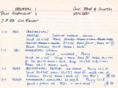
Card (Series) - Index Card, George Tibbits, Corner of Ford and Church Streets, Beechworth, 1976
George Tibbits, University of Melbourne. Faculty of Architecture, Building and Town & Regional PlanningIndex system that support the research for Beechworth : historical reconstruction / [by] George Tibbits ... [et al]Arranged by street names of BeechworthEach index card includes: street name and number of property, image of property, allotment and section number, property owners and dates of ownership, description of the property according to rate records, property floor plan with dimensions.beechworth, george tibbitsbeechworth, george tibbits -
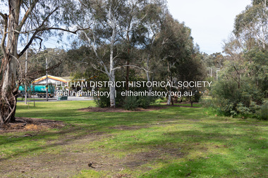 Eltham District Historical Society Inc
Photograph, Peter Pidgeon, Site of former Eltham Tennis Court, Wingrove Park, 2 Aug. 2022
View looking through Wingrove Park from near the Diamond Creek Trail towards the Coles Express Service Station and Mount Pleasant Road intersection. Comparison photo: SEPP_0720 Eltham Tennis Court, c.1909 and SEPP_0721 - Eltham Tennis Court, Lady Premiers 1909-1910 The tennis courts were located in Bremner’s Flats, present day Wingrove Park. The Eltham Lawn Tennis Club was formed on a Saturday evening, the 29th of October, 1898 at a meeting held at the Eltham State school. Twenty members were enrolled, and eight more shortly afterwards. Officers and a committee were duly elected, and the Treasurer was instructed to purchase the necessary requisites without delay. By the end of the first week in November all the requisites were to hand, two courts were marked out, and practice begun. The formal opening of the Courts of this Club took place on Saturday, November 12, 1898, when 26 members and their friends assembled. Part of a presentation by Peter Pidgeon to the Society, 13 August 2022 showcasing a series of photographs taken by John Henry Clark over the period 1895 to 1930. John Henry Clark was the youngest of three boys born to William Henry Clark (1823-1877) and Maria White (1843-1914). He and his brothers, William Charles Clark (1872-1945), Clement Kent Clark (1874-1912) operated a photography business (Clark Bros.) from 25 Thomas Street, Windsor near Prahran during the period c.1894 to 1914. Following death of Clement in September 1912 and their mother in 1914, the Clark Bros business appears to have dissolved, the premises demolished, and a new house was under construction in 1915. John set up business independently in 1914 operating out of 29 Moor Street, Fitzroy where he is registered in the 1914 and 1915 Electoral Rolls. By 1916 John had relocated to Eltham where he continued his practice as a photographer and took many of the early images around the district of Little Eltham. Around 1930 John changed professions and opened a small cobbler's shop in 1931 near the pond opposite Dalton Street adjacent to the Jarrold family cottage. He never married and continued his profession as a bootmaker from this little shop, maintaining a close relationship with Mrs Jarrold for the rest of their lives. His bootmaker shop remains today beside the Whitecloud cottage and is one of only three remaining shops in the area from the early 20th century.Comparative photo taken 2022 with one taken from same location over 100 years earlier by noted local photographer J.H. ClarkBorn Digitalbible street, eltham, j.h. clark photo (2022), bremner's flat, eltham lawn tennis club, eltham tennis court, main road, mount pleasant road, tennis court, wingrove park -
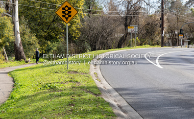 Eltham District Historical Society Inc
Photograph, Peter Pidgeon, Site of former pond, Main Road, Eltham, 2 Aug. 2022
The view is taken from Main Road opposite Dalton Street looking northwest across Wingrove Park Trail and White Cloud cottage which belonged to the Jarrold family Comparison photo: 00779 - Pond near Eltham Park, c.1910 Shows the pond near Eltham Park (later Eltham Lower Park) circa 1910. The view is taken from Maria Street (Main Road) opposite Dalton Street looking northwest across the Dalton Street road extension reserve (now Wingrove Park Trail) and Jarrold farm. A haystack is visible. Also visible is a kerosene streetlight and Jarrold family cottage The pond was drained by Council in 1932 due to claims of mosquitoes though locals such as Thekla Jarrold and John Clark disputed this and protested to Council about the draining. It was in this news article that Thekla stated she had lived there 39 years and John Clark 22 years without cause for concern. Part of a presentation by Peter Pidgeon to the Society, 13 August 2022 showcasing a series of photographs taken by John Henry Clark over the period 1895 to 1930. John Henry Clark was the youngest of three boys born to William Henry Clark (1823-1877) and Maria White (1843-1914). He and his brothers, William Charles Clark (1872-1945), Clement Kent Clark (1874-1912) operated a photography business (Clark Bros.) from 25 Thomas Street, Windsor near Prahran during the period c.1894 to 1914. Following death of Clement in September 1912 and their mother in 1914, the Clark Bros business appears to have dissolved, the premises demolished, and a new house was under construction in 1915. John set up business independently in 1914 operating out of 29 Moor Street, Fitzroy where he is registered in the 1914 and 1915 Electoral Rolls. By 1916 John had relocated to Eltham where he continued his practice as a photographer and took many of the early images around the district of Little Eltham. Around 1930 John changed professions and opened a small cobbler's shop in 1931 near the pond opposite Dalton Street adjacent to the Jarrold family cottage. He never married and continued his profession as a bootmaker from this little shop, maintaining a close relationship with Mrs Jarrold for the rest of their lives. His bootmaker shop remains today beside the Whitecloud cottage and is one of only three remaining shops in the area from the early 20th century.Comparative photo taken 2022 with one taken from same location over 100 years earlier by noted local photographer J.H. ClarkBorn Digitaleltham, j.h. clark photo (2022), bootmaker's shop, dalton street, diamond creek trail, jarrold cottage, main road, white cloud cottage, wingrove park trail -
 Eltham District Historical Society Inc
Photograph, Peter Pidgeon, Dalton Street, Eltham, 2 Aug. 2022
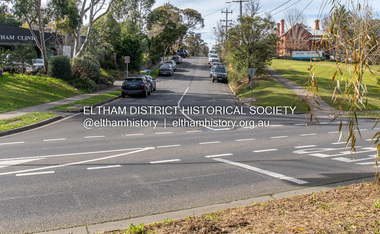
View looking up Dalton Street from near Main Road where the former pond was situated. The pond was drained by Council in 1932 due to concerns of mosquitoes, etc against the wishes of long standing residents such as Thekla Jarrold (39 years) and John Clark (22 years). On the right is the Eltham Primary Schoool No. 209 with the former Headmaster's residence and to the left is Eltham Clinic once the site of the Grant home. Comparison photo: SEPP_0643 In April 1935 the local paper reported on a story where a schoolgirl was talking whilst on her bicycle and it started moving off, flying down Dalton Street and across the main road missing cars and the guy wires for the telephone pole and hurtled 21 feet through the air into the drained pond suffering a broken arm and shock. She was rescued unconscious by John and taken into Mrs Jarrold’s for first aid. This was not the only instance of young girls losing control of bicycles down the hill. Part of a presentation by Peter Pidgeon to the Society, 13 August 2022 showcasing a series of photographs taken by John Henry Clark over the period 1895 to 1930. John Henry Clark was the youngest of three boys born to William Henry Clark (1823-1877) and Maria White (1843-1914). He and his brothers, William Charles Clark (1872-1945), Clement Kent Clark (1874-1912) operated a photography business (Clark Bros.) from 25 Thomas Street, Windsor near Prahran during the period c.1894 to 1914. Following death of Clement in September 1912 and their mother in 1914, the Clark Bros business appears to have dissolved, the premises demolished, and a new house was under construction in 1915. John set up business independently in 1914 operating out of 29 Moor Street, Fitzroy where he is registered in the 1914 and 1915 Electoral Rolls. By 1916 John had relocated to Eltham where he continued his practice as a photographer and took many of the early images around the district of Little Eltham. Around 1930 John changed professions and opened a small cobbler's shop in 1931 near the pond opposite Dalton Street adjacent to the Jarrold family cottage. He never married and continued his profession as a bootmaker from this little shop, maintaining a close relationship with Mrs Jarrold for the rest of their lives. His bootmaker shop remains today beside the Whitecloud cottage and is one of only three remaining shops in the area from the early 20th century.Comparative photo taken 2022 with one taken from same location over 100 years earlier by noted local photographer J.H. ClarkBorn Digitaleltham, j.h. clark photo (2022), dalton street, main road, eltham clinic, eltham primary school, headmaster's residence, state school no. 209 -
 Eltham District Historical Society Inc
Photograph, Peter Pidgeon, White Cloud Cottage, 701 Main Road, Eltham, 2 Aug. 2022
Jarrold Cottage built c.1853, also known as 'White Cloud", located at 701 Main Road, Eltham, opposite Dalton Street. The house remains intact and is listed on the Victorian Heritage Database and considered historically significant to the Shire of Nillumbik. The cottage was originally located closer to the Diamond Creek but was subject to flooding. It was dragged by horse to the present site shown, which was chosen for the higher ground that had been created as a result of land fill being deposited here from the quarry further around the bend on Main Road (site of present-day Eltham Primary School carpark) where the stone had been quarried for building the State School in Dalton Street. It had previously been rented for use as a Police Station / residence prior to the building of the permanent police house and station at the corner of Maria and Brougham streets in 1859. The cottage was purchased by Lena Skipper after the death of Thekla Jarrold in 1943 and remains in the family to present day (2022). Comparison photo: SEPP_0749 Part of a presentation by Peter Pidgeon to the Society, 13 August 2022 showcasing a series of photographs taken by John Henry Clark over the period 1895 to 1930. John Henry Clark was the youngest of three boys born to William Henry Clark (1823-1877) and Maria White (1843-1914). He and his brothers, William Charles Clark (1872-1945), Clement Kent Clark (1874-1912) operated a photography business (Clark Bros.) from 25 Thomas Street, Windsor near Prahran during the period c.1894 to 1914. Following death of Clement in September 1912 and their mother in 1914, the Clark Bros business appears to have dissolved, the premises demolished, and a new house was under construction in 1915. John set up business independently in 1914 operating out of 29 Moor Street, Fitzroy where he is registered in the 1914 and 1915 Electoral Rolls. By 1916 John had relocated to Eltham where he continued his practice as a photographer and took many of the early images around the district of Little Eltham. Around 1930 John changed professions and opened a small cobbler's shop in 1931 near the pond opposite Dalton Street adjacent to the Jarrold family cottage. He never married and continued his profession as a bootmaker from this little shop, maintaining a close relationship with Mrs Jarrold for the rest of their lives. His bootmaker shop remains today beside the Whitecloud cottage and is one of only three remaining shops in the area from the early 20th century.Comparative photo taken 2022 with one taken from same location over 100 years earlier by noted local photographer J.H. ClarkBorn Digitaleltham, j.h. clark photo (2022), dalton street, main road, bootmaker's shop, jarrold cottage, white cloud cottage, avenue of honour -
 Eltham District Historical Society Inc
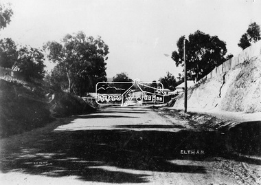
Negative - Photograph, J.H. Clark, Main Road, Eltham, c.1908
Gahan house on left, bakery on right at corner of York Street, Shillinglaw Cottage in distance. Newly constructed footpath (refer SEPP_0616) on eastern side between York Street and Bridge Street. Photo by J.H. Clark - John Henry Clark was one of four brothers that ran a photography business, Clark Bros. from 25 Thomas Street, Windsor between c.1894 and 1914. Source: Mr. L. Jarrold, Dromana, (formerly Eltham) Photographer: J.H. Clark John Henry Clark was the youngest of three boys born to William Henry Clark (1823-1877) and Maria White (1843-1914). He and his brothers, William Charles Clark (1872-1945), Clement Kent Clark (1874-1912) operated a photography business (Clark Bros.) from 25 Thomas Street, Windsor near Prahran during the period c.1894 to 1914. Following death of Clement in September 1912 and their mother in 1914, the Clark Bros business appears to have dissolved, the premises demolished, and a new house was under construction in 1915. John set up business independently in 1914 operating out of 29 Moor Street, Fitzroy where he is registered in the 1914 and 1915 Electoral Rolls. By 1916 John had relocated to Eltham where he continued his practice as a photographer and took many of the early images around the district of Little Eltham. Around 1930 John changed professions and opened a small cobbler's shop in 1931 near the pond opposite Dalton Street adjacent to the Jarrold family cottage. He never married and continued his profession as a bootmaker from this little shop, maintaining a close relationship with Mrs Jarrold for the rest of their lives. His bootmaker shop remains today beside the Whitecloud cottage and is one of only three remaining shops in the area from the early 20th century. There are a couple of images of Eltham taken by Clark Bros. in the Eltham District Historical Society collection, one such example being Hunniford’s Post Office with Miss Anne Hunniford out front (EDHS_00140 - marked on the back of the print, Clark Bros., 25 Thomas St. Windsor), which would date this image between c.1894 and 1914. Other early images of Eltham taken by John Henry Clark are marked on the face “J. H. Clark Photo” and it is assumed these are dated between 1914 and 1930. It is noted that the Grant of Probate for John H Clark of Eltham South dated 5 April !957 (513/387) records his occupation as "X Photographer".This photo forms part of a collection of photographs gathered by the Shire of Eltham for their centenary project book,"Pioneers and Painters: 100 years of the Shire of Eltham" by Alan Marshall (1971). The collection of over 500 images is held in partnership between Eltham District Historical Society and Yarra Plenty Regional Library (Eltham Library) and is now formally known as the 'The Shire of Eltham Pioneers Photograph Collection.' It is significant in being the first community sourced collection representing the places and people of the Shire's first one hundred years.Digital image 4 x 5 inch B&W NegJ.H. Clark Photoshire of eltham pioneers photograph collection, eltham, main road, gahan house, bakery, bridge street, footpath, j.h. clark photo, shillinglaw cottage, shillinglaw trees, york street -
 Eltham District Historical Society Inc
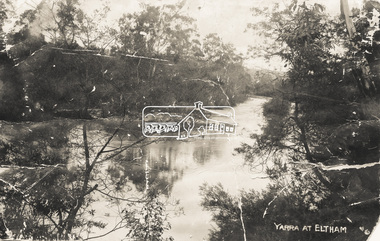
Photograph - Photo postcard, J.H. Clark, Yarra at Eltham, c.1910
This card depicts the Yarra River at Eltham circa 1910. It was addressed to "Mr J. L. Brown, "Elthamville", Tinning Street, Brunswick" most probably from an extended family member. From the same collection as accession no 00779, (Pond near Eltham Park) and no. 00780 (Eltham, J.H. Clark Photo - dated 20 May 1911). Sending postcards to family and friends including short messages was a common form of communication in the early 20th century. Photographer: J.H. Clark John Henry Clark was the youngest of three boys born to William Henry Clark (1823-1877) and Maria White (1843-1914). He and his brothers, William Charles Clark (1872-1945), Clement Kent Clark (1874-1912) operated a photography business (Clark Bros.) from 25 Thomas Street, Windsor near Prahran during the period c.1894 to 1914. Following death of Clement in September 1912 and their mother in 1914, the Clark Bros business appears to have dissolved, the premises demolished, and a new house was under construction in 1915. John set up business independently in 1914 operating out of 29 Moor Street, Fitzroy where he is registered in the 1914 and 1915 Electoral Rolls. By 1916 John had relocated to Eltham where he continued his practice as a photographer and took many of the early images around the district of Little Eltham. Around 1930 John changed professions and opened a small cobbler's shop in 1931 near the pond opposite Dalton Street adjacent to the Jarrold family cottage. He never married and continued his profession as a bootmaker from this little shop, maintaining a close relationship with Mrs Jarrold for the rest of their lives. His bootmaker shop remains today beside the Whitecloud cottage and is one of only three remaining shops in the area from the early 20th century. There are a couple of images of Eltham taken by Clark Bros. in the Eltham District Historical Society collection, one such example being Hunniford’s Post Office with Miss Anne Hunniford out front (EDHS_00140 - marked on the back of the print, Clark Bros., 25 Thomas St. Windsor), which would date this image between c.1894 and 1914. Other early images of Eltham taken by John Henry Clark are marked on the face “J. H. Clark Photo” and it is assumed these are dated between 1914 and 1930. It is noted that the Grant of Probate for John H Clark of Eltham South dated 5 April !957 (513/387) records his occupation as "X Photographer".Sending postcards to family and friends including short messages was a common form of communication in the early 20th century.Postcard in very poor condition which has been removed from an album. Glue residue and album page adhering preventing information being readFront: Yarra at Elthameltham, yarra river, brown family, j.h. clark photo -
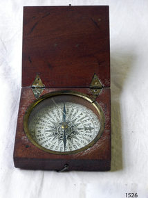 Flagstaff Hill Maritime Museum and Village
Instrument - Compass, c. 1839
This magnetic compass is a good size to fit easily into a person's pocket or personal luggage and is protected from knocks by its wooden case. It could have been used for reference when travelling on land or sea. There is no visible manufacturer's mark, which may mean that it was not of high monetary value. Leith is a district of Edinburgh in the country of Scotland, the U.K. It was once the Port of Edinburgh and many migrant ships departed from here bound for the Australian colony. It had a busy shipbuilding industry, with wet and dry docks. It appears from the inscription on the case "Chas Gray, LEITH, 1839" that this pocket compass once belonged to Charles M. Gray (Chas is a common abbreviation for the name Charles). The inscription coincides with the name, place and date that the Western Victorian pioneer Charles M. Gray left Scotland and arrived in Australia. Charles Gray was born in Anstruther, Scotland, in 1818. His family was connected with the Royal Marines, which may have created his nautical instruments such as this pocket compass. Charles Gray arrived in Hobson's Bay on 15 June 1839 on the ship “Midlothian”. That same ship had departed from Leith, Scotland on February 15th 1839. Did Charles Gray acquire the pocket compass in Leith, perhaps as a gift or a souvenir of his motherland? Charles Gray was an early squatter and went on to become a very successful settler as a sheep pastoralist in the Western District of what is now Victoria (originally the colony of New South Wales). He and his wife had a large property called “Nareeb Nareeb”, Green Hill Creek District (now Glenthompson), Victoria, from 1840-1886. He was also a local Councillor and Justice of the Peace, and had an interest in the local indigenous people; he named his property after their tribe. Charles returned to England in 1890 and died there in 1905. Charles Gray had written an account in 1890 of his life at Nareeb Nareeb, called Western Victoria in the Forties: "REMINISCENCES OF A PIONEER The Western District in the 1840's By Charles Gray" , a valuable historical reference to colonial Victoria. His book was published by the Hamilton Spectator in 1932. Charles Gray's photograph is one of 713 historical photographs of early Victorian settlers, created as a montage by Thomas Foster Chuck in 1872. The State Library of Victoria holds the framed montage titled “The Explorers and Early Colonists of Victoria”. To qualify for inclusion on this montage the Settlers must have arrived in Victoria before 1843. Charles Gray's photograph is number 349! The pocket compass is associated with Charles Gray, one of the early squatters and settlers in Western Victoria, possibly given to him as a parting gift on his emigration to Van Diemans land in 1839. The item is very significant as it's connection with one of Victoria's early pioneers is well provenanced by the inscriptions on the wooden case. Pocket compass, brass, set into a square wooden case with hinged lid and small hook catch. Compass is marked with 360 degrees and compass points and has two pointers; one to show magnetic north and one to set the direction of travel. Hinges are triangular and inset into the wood. The lid has an attached brass plaque with the inscription "Chas Gray, Leith, 1839" (It likely belonged to Charles Gray, Leith, UK, who migrated to Port Philip Australia in 1839 and became a successful pastoralist.) “Chas Gray / LEITH / 1839” engraved on brass plaque on lid.flagstaff hill, warrnambool, shipwrecked coast, flagstaff hill maritime museum, maritime museum, shipwreck coast, flagstaff hill maritime village, great ocean road, magnetic compass, pocket compass, charles m. gray, chas gray, migrrant from leith 1839, charles gray anstruther, scottland, ship midlothian 1839, squatter western victoria, settler western victoria, hobson's bay port phillip australia, charles gray nareeb nareeb - green hill creek district, western victoria in the forties: reminiscences of a pioneer by charles m. gray 1890, leith edinburgh u.k., western victoria in the forties: reminiscences of a pioneer - montage by thomas foster chuck 1872, charles gray, reminiscences of a pioneer, the western district in the 1840's, compass, scientific instrument, nautical instrument, direction, directional compass, navigation -
 Flagstaff Hill Maritime Museum and Village
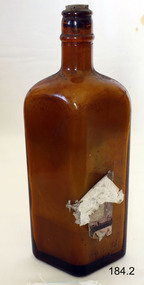
Container - Bottle, Pre 1974
Phenyle has been used for decades as a cleaner and disinfectant. It is well know for its use for cleaning outdoor toilets and easily identified by its strong odour. The brown glass bottle is immediately recognised as containing a poison. We've all seen them in a hundred different mystery movie scenes. The medicine cabinet opens and there, sitting on a shelf, is the incriminating object -- the ominous dark bottle with the skull and crossbones on the label. In off-screen reality, however, poison bottles have quite a different identity -- they are distinctive, varied, colorful -- and definitely collectible. Obviously, the one thing that sets the poison bottle apart from all other bottles is the need for prominent and immediate identification as a receptacle for toxic material, and this was achieved in a number of ways, including shape, color, embossing and labeling. Poisons were commonly found in the home for the purpose of controlling rodents and other pests, and were sold by grocers and druggists. For consumer protection, as far back as 1829, New York State made mandatory the marking of the bottles with the word "poison" in large letters. Then, in the middle of the 19th century, the American Pharmaceutical Association recommended legislation regarding identification of all poison bottles. In 1872 the American Medical Association also made recommendations -- namely that poison bottles be made of colored glass, and also have a rough surface on one side -- making them identifiable even in the dark -- and the word "poison" visible on the other (the skull and crossbones wasn't quite as ubiquitous as those movies led us to believe). However, passing these laws was not easy, and the manufacturers were essentially left to do as they wished. For collectors, the high point of poison bottle manufacturing was the period ranging roughly from the 1870s to the 1930s. At that time some, of the bottles were distinguished by particularly bright colors, such as cobalt blue (the most common) and emerald green. Others, particularly rare and collectible, had unusual -- and appropriate -- shapes, including skulls, leg bones and coffins. In order to better identify these lethal vessels by feel (not forgetting that there were many people in this period who could not read) when groping for them in the dark, they had such elaborate tactile patterns as quilted diamonds, lattices, hobnails and prominent vertical or horizontal ribbing, as well as spiky knobs and ridges. In addition, many had sharp points on top for the same precautionary purpose. Further efforts to distinguish poison bottles from others included uncommon multisided and triangular shapes, and unusual, hard-to-open tops, the predecessors of the modern child-proof openings. https://www.southcoasttoday.com/story/lifestyle/2001/08/19/poison-bottles-steeped-in-history/50352280007/The recognition and awareness of bottles containing poisonpous substances is extremely important for safety reasons.Bottle, brown glass, diamond shaped. "Bright Star" phenyle. Paper label attached, but peeling off and badly damaged. Corked with contents. Text moulded into glass, some with a border of stars. Poisonous contents, not to be taken. Registered Number 2140. Volume is 20 fluid ounces. Printed label "Bright Star". Text is moulded in the glass in raised lettering: "PHENYLE" outlined and decorated with star border. "POISONOUS", "NOT TO BE TAKEN" "V / DM / A" within oval, "REGD NO. 2140" (D and O are smaller and underlined) . Base is marked "F190".flagstaff hill, warrnambool, shipwrecked-coast, flagstaff-hill, flagstaff-hill-maritime-museum, maritime-museum, shipwreck-coast, flagstaff-hill-maritime-village, bright star, phenyl, cleaning and disinfecting chemical, poison, bottles -
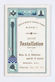 City of Greater Bendigo - Civic Collection
Memorabilia - Invitation and menu card, Joint Installation of Bros. K.J. Fullerton and W. F. Creeth, 1909
Freemasonary or Masonry has its beginnings in local guilds of stonemasons who from the end of 13th century regulated the qualification of stonemasons. Modern Freemasonry uses scriptures which include ritual practices and ethical conduct as part of its foundation and every member must profess a belief in a Supreme Being. Women are not allowed to be admitted and discussion of religion and politics is not to take place within the lodge. Freemasons meet in local Lodges which are supervised at a regional level by a Grand Lodge. The degrees of Freemasonry retain the three grades of medieval craft guilds, those of Entered Apprentice, Journeyman or fellow (now called Fellowcraft), and Master Mason. The candidate of these three degrees is progressively taught the meanings of the symbols of Freemasonry and entrusted with grips, signs, and words to signify to other members that he has been so initiated. The degrees are part allegorical morality play and part lecture. Candidates for Freemasonry will usually have met the most active members of the Lodge they are joining before being elected for initiation. (https://en.wikipedia.org/wiki/Freemasonry) The Golden Lodge of Sandhurst was established as the first Masonic Lodge in Bendigo in 1854. Many prominent men including City Councilors were lodge members at it was a popular way for men to socialise. As the masonic movement expanded further lodges were established in Bendigo and the surrounding Boroughs and Shires. The Golden and Corinthian Lodges purchasing two blocks of land in a prominent position in View Street in 1866 with the intention of erecting a new temple and after amalgamating in 1872 appointed architects Vahland and Getzschmann to design the building. The Bendigo Masonic Hall (now the Capital Theatre) was built in 1873 -74 for both public and private use and contained lodge rooms, a public tavern anda concert hall. The Masonic section occupied the northern side of the building at ground floor level and included a lodge room at the rear, a library and reading room, and other affiliated rooms. Walls of the entry hall and lodge room were decorated with classical columns and panels ornamented with Masonic emblems. The upper level of the building contained a large hall with balcony at the north end and removable stage at the south end. Elaborately decorated with Masonic emblems, this hall was used for Masonic purposes as well as being available to the wider community for social events. The tavern, which became known as the Masonic Hotel, occupied the basement and the ground floor of the southern side of the building and included a sitting room, parlours, billiard room, bedrooms, kitchen, cellars and servants' rooms. It appears that two public entrances were provided for this section, one directly from street level into the basement, the other from the public entry hall. Invitation for the Installation of two Lodge Brothers. Half fold design printed in gold, brown, light blue, dark blue and black ink on white card. Front and back cover decorated with masonic symbols. Menu listed inside. Front cover: Zenith & Golden Corinthian Lodges,/ No. 52 & No. 7./ Joint / Installation / of / Bros. K. J. Fullerton / and W. F Creeth / Masonic Hall / Wednesday, June 30th , 1909 bendigo masonic hall, capital theatre bendigo, milburn catering bendigo, making a nation exhibition, bendigo masonic lodge, city of greater bendigo events, city of greater bendigo community groups -
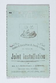 City of Greater Bendigo - Civic Collection
Memorabilia - Invitation and menu card, Joint Installation of Bros. R.T. Trembath and L. A. Sonnenberg, 1910
Freemasonary or Masonry has its beginnings in local guilds of stonemasons who from the end of 13th century regulated the qualification of stonemasons. Modern Freemasonry uses scriptures which include ritual practices and ethical conduct as part of its foundation and every member must profess a belief in a Supreme Being. Women are not allowed to be admitted and discussion of religion and politics is not to take place within the lodge. Freemasons meet in local Lodges which are supervised at a regional level by a Grand Lodge. The degrees of Freemasonry retain the three grades of medieval craft guilds, those of Entered Apprentice, Journeyman or fellow (now called Fellowcraft), and Master Mason. The candidate of these three degrees is progressively taught the meanings of the symbols of Freemasonry and entrusted with grips, signs, and words to signify to other members that he has been so initiated. The degrees are part allegorical morality play and part lecture. Candidates for Freemasonry will usually have met the most active members of the Lodge they are joining before being elected for initiation. (https://en.wikipedia.org/wiki/Freemasonry) The Golden Lodge of Sandhurst was established as the first Masonic Lodge in Bendigo in 1854. Many prominent men including City Councilors were lodge members at it was a popular way for men to socialise. As the masonic movement expanded further lodges were established in Bendigo and the surrounding Boroughs and Shires. The Golden and Corinthian Lodges purchasing two blocks of land in a prominent position in View Street in 1866 with the intention of erecting a new temple and after amalgamating in 1872 appointed architects Vahland and Getzschmann to design the building. The Bendigo Masonic Hall (now the Capital Theatre) was built in 1873 -74 for both public and private use and contained lodge rooms, a public tavern anda concert hall. The Masonic section occupied the northern side of the building at ground floor level and included a lodge room at the rear, a library and reading room, and other affiliated rooms. Walls of the entry hall and lodge room were decorated with classical columns and panels ornamented with Masonic emblems. The upper level of the building contained a large hall with balcony at the north end and removable stage at the south end. Elaborately decorated with Masonic emblems, this hall was used for Masonic purposes as well as being available to the wider community for social events. The tavern, which became known as the Masonic Hotel, occupied the basement and the ground floor of the southern side of the building and included a sitting room, parlours, billiard room, bedrooms, kitchen, cellars and servants' rooms. It appears that two public entrances were provided for this section, one directly from street level into the basement, the other from the public entry hall. Invitation for the Installation of two Lodge Brothers. Horizontal fold printed in black ink on blue card. Embossed cover with scalloped edging. Front and back cover decorated with masonic symbols. Menu listed inside. Front cover: golden & Corinthian & Zenith Lodges / No. 7 and Mo. 52 / joint Installation / of / Bros, R. T. Trembath and L. A. Sonnenber / Masonic Hall, Bendigo / Wednesday, June 29th, 1910. bendigo masonic hall, capital theatre bendigo, milburn catering bendigo, brockley printers bendigo, making a nation exhibition, bendigo masonic lodge, city of greater bendigo community groups, city of greater bendigo events -
 City of Greater Bendigo - Civic Collection
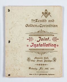
Memorabilia - Invitation and Menu Card, Joint Installation, 1905
Freemasonary or Masonry has its beginning in local guilds of stonemasons which from the end of 13th century regulated the qualification of stonemasons. Modern Freemasonry uses scriptures which include ritual practices and ethical conduct as part of its foundation and every member must profess a belief in a Supreme Being. Women are not allowed to be admitted and discussion of religion and politics is not to take place within the lodge. Freemasons meet in local Lodges which are supervised at a regional level by a Grand Lodge. The degrees of Freemasonry retain the three grades of medieval craft guilds, those of Entered Apprentice, Journeyman or fellow (now called Fellowcraft), and Master Mason. The candidate of these three degrees is progressively taught the meanings of the symbols of Freemasonry and entrusted with grips, signs, and words to signify to other members that he has been so initiated. The degrees are part allegorical morality play and part lecture. Candidates for Freemasonry will usually have met the most active members of the Lodge they are joining before being elected for initiation. (https://en.wikipedia.org/wiki/Freemasonry) The Golden Lodge of Sandhurst was established as the first Masonic Lodge in Bendigo in 1854. Many prominent men including City Councilors were lodge members at it was a popular way for men to socialise. As the masonic movement expanded further lodges were established in Bendigo and the surrounding Boroughs and Shires. The Golden and Corinthian Lodges purchasing two blocks of land in a prominent position in View Street in 1866 with the intention of erecting a new temple and after amalgamating in 1872 appointed architects Vahland and Getzschmann to design the building. The Bendigo Masonic Hall (now the Capital Theatre) was built in 1873 -74 for both public and private use and contained lodge rooms, a public tavern anda concert hall. The Masonic section occupied the northern side of the building at ground floor level and included a lodge room at the rear, a library and reading room, and other affiliated rooms. Walls of the entry hall and lodge room were decorated with classical columns and panels ornamented with Masonic emblems. The upper level of the building contained a large hall with balcony at the north end and removable stage at the south end. Elaborately decorated with Masonic emblems, this hall was used for Masonic purposes as well as being available to the wider community for social events. The tavern, which became known as the Masonic Hotel, occupied the basement and the ground floor of the southern side of the building and included a sitting room, parlours, billiard room, bedrooms, kitchen, cellars and servants' rooms. It appears that two public entrances were provided for this section, one directly from street level into the basement, the other from the public entry hall. Invitation for the Installation of unnamed Brothers. Half fold printed in gold and red ink on cream coloured card. Embossed cover with plain edging. Front and back cover decorated with masonic symbols. Menu listed inside. Front cover: The Zenith and Golden and Corinthian Lodges ? Joint Installation / Masonic Hall, Bendigo / Wednesday, June 28th, 1905 / Bro J.O.R Milburn Caterer bendigo masonic hall, capital theatre bendigo, milburn catering bendigo, making a nation exhibition, james printer eaglehawk, bendigo masonic lodge, city of greater bendigo community groups -
 City of Greater Bendigo - Civic Collection
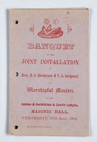
Memorabilia - Invitation, Joint Installation of Bros. R.O. Henderson & T. L. Sargeant, 1906
Freemasonary or Masonry has its beginnings in local guilds of stonemasons who from the end of 13th century regulated the qualification of stonemasons. Modern Freemasonry uses scriptures which include ritual practices and ethical conduct as part of its foundation and every member must profess a belief in a Supreme Being. Women are not allowed to be admitted and discussion of religion and politics is not to take place within the lodge. Freemasons meet in local Lodges which are supervised at a regional level by a Grand Lodge. The degrees of Freemasonry retain the three grades of medieval craft guilds, those of Entered Apprentice, Journeyman or fellow (now called Fellowcraft), and Master Mason. The candidate of these three degrees is progressively taught the meanings of the symbols of Freemasonry and entrusted with grips, signs, and words to signify to other members that he has been so initiated. The degrees are part allegorical morality play and part lecture. Candidates for Freemasonry will usually have met the most active members of the Lodge they are joining before being elected for initiation. (https://en.wikipedia.org/wiki/Freemasonry) The Golden Lodge of Sandhurst was established as the first Masonic Lodge in Bendigo in 1854. Many prominent men including City Councilors were lodge members at it was a popular way for men to socialise. As the masonic movement expanded further lodges were established in Bendigo and the surrounding Boroughs and Shires. The Golden and Corinthian Lodges purchasing two blocks of land in a prominent position in View Street in 1866 with the intention of erecting a new temple and after amalgamating in 1872 appointed architects Vahland and Getzschmann to design the building. The Bendigo Masonic Hall (now the Capital Theatre) was built in 1873 -74 for both public and private use and contained lodge rooms, a public tavern anda concert hall. The Masonic section occupied the northern side of the building at ground floor level and included a lodge room at the rear, a library and reading room, and other affiliated rooms. Walls of the entry hall and lodge room were decorated with classical columns and panels ornamented with Masonic emblems. The upper level of the building contained a large hall with balcony at the north end and removable stage at the south end. Elaborately decorated with Masonic emblems, this hall was used for Masonic purposes as well as being available to the wider community for social events. The tavern, which became known as the Masonic Hotel, occupied the basement and the ground floor of the southern side of the building and included a sitting room, parlours, billiard room, bedrooms, kitchen, cellars and servants' rooms. It appears that two public entrances were provided for this section, one directly from street level into the basement, the other from the public entry hall. Invitation for the Installation of Brothers Henderson and Sargeant. Half fold printed in red ink on grey / mauve coloured card with plain edging. Menu listed inside on left, toasts listed on inside right. Front cover: Banquet / at the / Joint Installation / of / Brox, R. O Henderson & T. L. Sargeant / as / Worshipful Masters / of the / Golden and Corinthian & Zenith Lodges / Masonic Hall / Wednesday, 27th June 1906 bendigo masonic hall, capital theatre bendigo, milburn catering bendigo, making a nation exhibition, brockley printers bendigo, bendigo masonic lodge, city of greater bendigo community groups -
 City of Greater Bendigo - Civic Collection
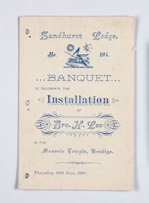
Memorabilia - Invitation, Joint Installation of Bros. H. Lee, 1907
Freemasonary or Masonry has its beginnings in local guilds of stonemasons who from the end of 13th century regulated the qualification of stonemasons. Modern Freemasonry uses scriptures which include ritual practices and ethical conduct as part of its foundation and every member must profess a belief in a Supreme Being. Women are not allowed to be admitted and discussion of religion and politics is not to take place within the lodge. Freemasons meet in local Lodges which are supervised at a regional level by a Grand Lodge. The degrees of Freemasonry retain the three grades of medieval craft guilds, those of Entered Apprentice, Journeyman or fellow (now called Fellowcraft), and Master Mason. The candidate of these three degrees is progressively taught the meanings of the symbols of Freemasonry and entrusted with grips, signs, and words to signify to other members that he has been so initiated. The degrees are part allegorical morality play and part lecture. Candidates for Freemasonry will usually have met the most active members of the Lodge they are joining before being elected for initiation. (https://en.wikipedia.org/wiki/Freemasonry) The Golden Lodge of Sandhurst was established as the first Masonic Lodge in Bendigo in 1854. Many prominent men including City Councilors were lodge members at it was a popular way for men to socialise. As the masonic movement expanded further lodges were established in Bendigo and the surrounding Boroughs and Shires. The Golden and Corinthian Lodges purchasing two blocks of land in a prominent position in View Street in 1866 with the intention of erecting a new temple and after amalgamating in 1872 appointed architects Vahland and Getzschmann to design the building. The Bendigo Masonic Hall (now the Capital Theatre) was built in 1873 -74 for both public and private use and contained lodge rooms, a public tavern anda concert hall. The Masonic section occupied the northern side of the building at ground floor level and included a lodge room at the rear, a library and reading room, and other affiliated rooms. Walls of the entry hall and lodge room were decorated with classical columns and panels ornamented with Masonic emblems. The upper level of the building contained a large hall with balcony at the north end and removable stage at the south end. Elaborately decorated with Masonic emblems, this hall was used for Masonic purposes as well as being available to the wider community for social events. The tavern, which became known as the Masonic Hotel, occupied the basement and the ground floor of the southern side of the building and included a sitting room, parlours, billiard room, bedrooms, kitchen, cellars and servants' rooms. It appears that two public entrances were provided for this section, one directly from street level into the basement, the other from the public entry hall. Invitation for the Installation of Brother Lee. Half fold printed in blue ink on cream coloured card with plain edging. Menu listed inside on left, toasts listed on inside right, officers listed on back cover. Front cover: Sandhurst Lodge / No 194 / Banquet / to celebrate the / Installation / of / Brother H. Lee / in the / Masonic Temple, Bendigo / Thursday, 20th June 1907 bendigo masonic hall, capital theatre bendigo, milburn catering bendigo, making a nation exhibition, bendigo masonic lodge, city of greater bendigo events, city of greater bendigo community groups -
 Melton City Libraries
Photograph, Ann Dowling, c.1857
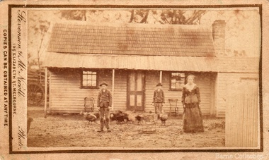
On the 12th of March 1891 documents show Ann Myer’s application for a dairy. A small addition to the front right side of the house can be seen in the photo of Ann and her two sons. The dairy remained until the house was demolished in 1969. Mary Dowling’s sisters Ann and Eliza appear on the shipping list to Australia arriving in Melbourne as assisted immigrants on the ‘Hotspur’ on the 25th June 1855. Their ages were recorded as 19 and 20 years. Ann Dowling’s records contains receipts for the rent of land in the parish of Kororoit in 1865. In 1867 Ann married Henry Miers at St Patricks Cathedral on the 28th May at age 26 years. Other spelling of the family name have been spelt, Miers, Myres, Mears and eventually became Myers. Henri came from Prussia but little information about his life before he married Ann. Ann and Henri had a small house built c1860 near Ryans Creek also known a Myers Gully. Henry was a labourer. According to notes in Edna’s research the original house consisted of two rooms and was built by Russell, and more rooms were added later built by Paddy Burns, the grandfather of Nick Burns. Additions were made to extend the south veranda and north further skillion rooms were added.Ann and Henri had four sons, Henry born in 1870, Thomas in 1872, George in 1874 and Frederick in 1877. By the December of 1886 tragedy struck again when father Henry fell from the top of a hay wagon at Darlingsford when the driver Ralph Parkinson failed to warn him the horses where about to move. Henry asked to be taken home where he died the next day. Henri Miers was aged 51 years at his death. The Parkinson family paid compensation for causing the death of Henry. Ralph Parkinson died shortly after. The Myers boys received their education at Melton State School. Their handwriting is testament to the benefit of receiving an education to grade 8. Frederick the youngest son gained his Merit Certificate on the 10th of October 1889. They also received books inscribed by the Head Teacher. Ann was illiterate and was aged about 15 years when she arrived in Australia and was dependent on youngest son Frederick. Although at a disadvantage she managed her legal affairs. Frederick Myers married Martha Watson in 1908. Thomas Myers died in November 1909 Ann Dowling Myers died in October 1924. She lived in the family home with Martha Fred, grandson Fred and granddaughters Marjorie and Edna who was aged six at her death. Her son Henry died in 1950 followed by George in 1954 and Frederick in 1963. Ann with two of her children and turkeys at the front of their housepioneer families, local identities -
 Eltham District Historical Society Inc
Document - Folder, Wellers of Kangaroo Ground, 1984-2017
Wellers of Kangaroo Ground Vertical File Contents: 1. Article: History of Wellers Restaurant by Sandra Cahir, revised 2017. 7 pages 2. Article: Weller’s Hotel of Kangaroo Ground (final draft) by Jim Allan, 1 June 2017, including feedback email from Sandra Cahir (7 May 2017). 3. Printout of online image - Kangaroo Ground landholders from 1841, Kangaroo Ground Presbyterian Church. (2022, June 29). Retrieved from https://kgpc.pcvic.org.au/images/history_images/Kangaroo-Ground-landholders.jpg 4. Folder of printouts of historical newspaper articles referencing the hotel 1866-1911 https://trove.nla.gov.au/list/163201 5. Printouts (various versions) from Victorian Heritage Database (National Trust and Nillumbik Shire) https://vhd.heritagecouncil.vic.gov.au/ 6. Collection of research notes, copies of records from various publications including EDHS Chronology of Events and Kangaroo Ground: The Highland Taken by Mick Woiwod, pp90, 180-181 (EDHS_01618). 7. Report: Request for ministerial amendment to use the property as a restaurant, includes existing conditions and plan for development, 1 November 1984 8. Papers donated by Diana and Peter Bassett-Smith including: a. Photocopy of Weller’s Hotel, Licensee M. Weller b. Letter: Shire of Eltham to Office of the Secretary for Planning and Environment, 23 Feb 1984 - Information regarding inclusion of Wellers Hotel into the Historic Buildings Register c. Letter: Historic Buildings Council letter to Peter Bassett-Smith seeking historical information on Wellers Hotel, 10 Jan 1985 d. Memo: Peter Bassett-Smith to Robert N. Hendrey on history of Wellers Hotel, 28 Jan 1985 - Includes extract of information about Mary Weller, Dept. of Crown Lands and Survey Map NILLUMBIK showing properties of John Weller and E. Weller and a Diamond Valley News article from 10 April 1973, p11, "Eltham on old coach route" 9. Information about the Weller family including family trees from various sources a. Edward Weller, Pioneer Families in Victoria, http://mepnab.netau.net/w/w09.html, 1 Jan 2017 (link broken) b. The WELLER family tree. (2017, January 1), 2 pages. Retrieved from https://www.weller.org.uk/cgi-bin/FamilyTree/ShowFamily.pl? and 27 pages Retrieved from https://www.weller.org.uk/cgi-bin/FamilyTree/ShowFamily.pl?ListAllPeople=A c. Edward WELLER on the WELLER family tree. (2017, January 1), 1 page. Retrieved from https://www.weller.org.uk/cgi-bin/FamilyTree/ShowFamily.pl?PersonID=516 d. Photograph (print copy), believed to be Edward Weller, 1836-1883 e. Photograph (print copy), Gravestone of Weller family at Kangaroo Cemetery f. Wellers of Kangaroo Ground, 1 page, possibly from History, http://www.wellers.com.au (broken) c.2016 g. Edward and Mary Weller miscellaneous biographical research notes (by Jim Allen?) including from Ancestry.com, and extracts from Chappel file (EDHS_04448) with relevant names highlighted h. Information about the Vernon Pitman family from Ancestry.com 10. Newspaper articles: a. Cobb & Co called here by Marguerite Marshall; Diamond Valley News, May 4, 1982, p2 b. Rich is history, 30 August 1983 (very similar to previous article) c. Weller’s Pub - restaurant, craft store or art gallery? Diamond Valley News, October 22, 1985, p3 d. Despite years of neglect a magical charm lies waiting, Diamond Valley News, October 29, 1985 e. Old pub fate still in doubt, Diamond Valley News, (?) 29 October 1985 f. Renovated Weller’s Pub to begin its new stage of life, DVN 26 January 1988 g. Wellers Restaurant, Lynne Hillier, Network, October 1988, p14 h. Revolution at Wellers, Nillumbik Mail, December 20, 2000 i. Wellers brings on good times, Valley Weekly, June 22, 2005 j. Dine in with ideal outlook, Valley News, 10 August 2005 k. Advertisement: Wellers of Kangaroo Ground, Enjoy lunch, afternoon tea and dinner at Wellers from Tuesday to Sunday, Valley Weekly, Wednesday, August 31, 2005 l. Advertisement: Wellers of Kangaroo Ground, Appearing live; Normie Rowe Fri 24 Feb, Diamond Valley Leader February 22, 2006, p11 m. Advertisement: Wellers of Kangaroo Ground, Lunch Special, Diamond Valley Leader March 27, 2010 n. Braithwaite abounds to Kangaroo Ground, Gig Guide, The Age, Friday, October 8, 2010, p14 o. History up for grabs, Diamond Valley Leader, March 28, 2012 p. Advertisement: Wellers Restaurant, Freehold only for sale, Morrison Kleeman, Diamond Valley Leader, March 28, 2012 q. Restaurant’s crash course, Megan Bailey, Diamond Valley Leader, January 1, 2014, p3. Also accessible online - Staff praised after car crashes through Kangaroo Ground eatery. (2022, June 29). Retrieved from https://www.heraldsun.com.au/leader/north/staff-praised-after-car-crashes-through-kangaroo-ground-eatery/news-story/021c896a1ab6d76bd6b73f2e57dc1854 r. Eatery set for revival, Brittany Shanahan, Diamond Valley Leader 15 February 2017; Also, online as Much-loved Wellers of Kangaroo Ground to be relaunched as Italian restaurant Fondata 1872. (2022, June 29). Retrieved from https://www.heraldsun.com.au/leader/north/muchloved-wellers-in-kangaroo-ground-to-be-relaunched-as-italian-restaurant-fondata-1872/news-story/665777fb347584ef483867ae2b536a8f s. Fondata 1872 proves a big hit with food, Diamond Valley Leader 3 May 2017, p3 11. Wellers of Kangaroo Restaurant Bar Entertainment Functions, tri-fold brochure promotional brochure 12. Website Printout: Wellers Restaurant, Live Guide, (2017, January 5). Retrieved from http://www.liveguide.com.au/Restaurants_Bars/VIC/Kangaroo_Ground/Food_Styles/3... 13. Website Printout: Wellers of Kangaroo Ground, Only Melbourne (2017, January 30). Retrieved from http://www.onlymelbourne.com.au/wellers-of-kangaroo-ground 14. Printouts from Fondata 1872 website and Facebook page including colour photograph of sign in front and business card (2017). Related EDHS Collection items • Wellers Hotel of Kangaroo Ground by Jim Allen, Part 1, Newsletter No. 235, Eltham District Historical Society, August 2017. Retrieved from https://elthamhistory.files.wordpress.com/2017/08/edhs-nl-235-aug-2017.pdf • Wellers Hotel of Kangaroo Ground by Jim Allen, Part 2, Newsletter No. 236, Eltham District Historical Society, October 2017. Retrieved from https://elthamhistory.files.wordpress.com/2017/10/edhs-nl-236-oct-2017.pdf • EDHS_03997 - Slide, Wellers Hotel, Pitmans Corner, Eltham-Yarra Glen Road, Kangaroo Ground, c.1975 https://victoriancollections.net.au/items/5e59e36221ea671798ac40eb • EDHS_03998 - Slide, Wellers Hotel, Pitmans Corner, Eltham-Yarra Glen Road, Kangaroo Ground, c.1975 https://victoriancollections.net.au/items/5e59e39e21ea671798ac9c27 • EDHS_03999 - Slide, Wellers Hotel, Pitmans Corner, Eltham-Yarra Glen Road, Kangaroo Ground, c.1975 https://victoriancollections.net.au/items/5e59e3c721ea671798acd2ef • EDHS_04000 - Slide, Wellers Hotel, Pitmans Corner, Eltham-Yarra Glen Road, Kangaroo Ground, c.1975 https://victoriancollections.net.au/items/5e59e3e021ea671798acfd68 • EDHS_04066-18 - Photograph, Wellers Restaurant, Eltham-Yarra Glen Road, Kangaroo Ground, c.Mar. 1989 https://victoriancollections.net.au/items/610f4dafa346aadcee7ac79c • EDHS_04041-26 - Photograph, Wellers Restaurant, 150 Eltham-Yarra Glen Road, Kangaroo Ground, c.May 1988 https://victoriancollections.net.au/items/610e2f4a7d65e7c945a35e69 • EDHS_04437 – Newsclipping, Renovated Weller's Pub to begin its new stage of life by Linley Hartley, Diamond Valley News, 26 January 1988 https://victoriancollections.net.au/items/5de4913921ea6710a46a85c7 • EDHS_04438 - Newsclipping, Wellers Restaurant by Lynne Hillier, Network, October 1988, p14 https://victoriancollections.net.au/items/5de4916f21ea6710a46aea0f • ArtStreams magazine (from Volume 9, 2004) ‘partnered' with Wellers in promoting and supporting the arts and culture. Various advertisements throughout, particular with live performance acts. Numerous references throughout to art and music performances on site. • Stephen Cummings and Joe Camilleri at Wellers Kangaroo Ground, ArtStreams, Vol. 9, No. 4, Sep/Oct 2004, p17 EDHS_04406 - Journal, ArtStreams: Whittlesea, Banyule, Darebin, Manningham, Nillumbik, Yarra; Vol. 9, No. 4, Sep-Oct 2004 https://victoriancollections.net.au/items/5bcc086021ea6804a82a92a9 • Daryl Braithwaite rocks up at Wellers, Fiona Sievers, ArtStreams, Vol.10 No.2, 2005, pp6-7 EDHS_04409 - Journal, ArtStreams: Vol. 10, No. 2, 2005 https://victoriancollections.net.au/items/60f5416ab06f0c13a9419541 • Ephemeral Sculpture by Peter Dougherty, ArtStreams, Vol.10 No.3, 2005, pp7-9. About sculptures created in or on the grounds of culinary establishments throughout the Shire. - Denise Keele-Bedford constructed ‘Ou Well’ at Wellers Restaurant and Vicky Shukuroglou, also at Wellers set up cotton banners printed and painted with natural dyes from onion skins, spinach, radish beetroot, turmeric and charcoal. EDHS_04410 - Journal, ArtStreams: Vol. 10, No. 3, 2005 https://victoriancollections.net.au/items/60f5436db06f0c13a941ae19 • Music at Wellers Restaurant, ArtStreams, Vol.10 No.4, 2005, p23 EDHS_04411 - Journal, ArtStreams: Vol. 10, No. 4, 2005 https://victoriancollections.net.au/items/60f543e4b06f0c13a941b059 • Weller’s Pub, Diamond Valley sketchbook / text by Brian McKinlay ; drawings by Graham Hawley, 1973, pp42-43 EDHS_00856 - https://victoriancollections.net.au/items/590852edd0ce7b14e8177da3 • Gold Field Coaches Stopped Here, Nillumbik now and then / Marguerite Marshall; photographs Alan King with Marguerite Marshall, 2008, pp86-87 EDHS_00977 - https://victoriancollections.net.au/items/5935f315d0cdd42c80f9cc52 External Links: • Historic Kangaroo Ground venue comes up for rare sale. (2022, June 29). Retrieved from https://www.smh.com.au/business/companies/historic-kangaroo-ground-venue-comes-up-for-rare-sale-20120325-1vshw.html • Wellers, Kangaroo Ground property sold with leaseback. (2022, June 29). Retrieved from https://www.urban.com.au/expert-insights/investing/37735-wellers-kangaroo-ground-property-sold-with-leaseback • Wellers, Kangaroo Ground | With Mark Seymour, at one of his …. (2022, June 29). Retrieved from https://www.flickr.com/photos/robertmilesdesign/4564390893/ • 2016 Notice of proposed deregistration - WELLERS OF KANGAROO GROUND PTY LTD 124 435 409. (2022, June 29). Retrieved from https://publishednotices.asic.gov.au/browsesearch-notices/notice-details/WELLERS-OF-KANGAROO-GROUND-PTY-LTD-124435409/35d43b89-159a-4435-963f-daec688a61ca • Search results for: Websites (archived). (2022, June 29). Retrieved from https://trove.nla.gov.au/search/category/websites?keyword=%22wellers%20restaurant%22 29 June 2022 edward weller, wellers of kangaroo ground, wellers hotel, wellers restaurant, mary weller, pittmans corner, fondata 1812 at wellers, historic buildings register, hotels, john weller, kangaroo ground, pitman's corner, bassett-smith collection -
Federation University Historical Collection
Document, Zelda Martin, Central Victorian Goldmining towns - Boom Towns or Ghost Towns?, c1996
Zelda Martin was a PhD candidate at the University of Melbourne.[.1] 4th item in light blue display book titled Research Approach/Overview of Chapters/Confirmation of Canditure/Chapters1,2,3&4 of proposed thesis. *Twenty-seven page article on Victorian goldfields towns titled: Central Victorian Goldmining Towns - Boom Towns or Ghost Towns. The article was written during the author's PhD study. It outlines the context methodology, and resources and the chapters of the proposed thesis: (1) Central Victorian Goldmining Towns - The Context (2) Contemporary Views of the Factors Necessary for Town Growth (3) Outward Manifestations of Town Growth (4) The Trappings of Government (5-9) The Main Towns and Their Hinterland. [.2] 5th item in Light Blue display book as above item. *Chapter 1 of proposed thesis titled 'Pick, Shovel and Tin Dish Mining.' Covers in Section A: Central Victoria - Pre 1851: Aborigines in Central Victoria, Squatters, and Government. Section B: The years 1851-1854: The Early Gold Rushes, Government Reaction, Township Surveys, Legislation, Town Development, Local Government and Early Settlement. [.3] 6th item in Light Blue display book as above item. *2A of proposed thesis titled 'Contemporary Views of the Factors Necessary for Town Growth'. Similar information to Chapter 1 plus extra re towns and maps. Sections: Introduction, Context of Place - Geographical Towns Listed, The Context of Time - Pre1851 Aborigines, Governance of Port Phillip, The Squatters, The Villages of Central Victorian Highlands, Conclusion, Condensed Version of Chapter2B. [.4] 7th item in Light Blue display book as above item. *Chapter2B of proposed thesis. Sections: Area of Research, Schools, Banks, Newspapers, Progress Association, Town Development - Sandhurst (Bendigo), Ballarat, Castlemaine,, Maryborough, Ararat and Stawell. [.5] 8th item in Light Blue display book as above item. *Chapter 3 of proposed thesis titled 'Outward Manifestations of Town Growth'. Sections: Introduction, Contemporary Writing, Educationalists, The Bankers, The Townsfolk, Current Theory, General Theories of Urban Development, and Conclusion. [.6] 9th item in Light Blue display book as above item. *Chapter 4 of proposed thesis titled 'Trappings of Government' Sections: Introduction, Early Government Attitudes to Mining and Town Development, Law and Order, Township Surveys, Legislation, Local Government, Transport and Communication, The People and Lobbyists. [.7] 10th item in Light Blue display book as above item. *'The Rise and Fall of Central Victorian Goldmining Towns'. Includes a map showing main Goldfields, a table showing towns and villages at two points in time - 1857 and 1871; a Bibliography of Primary and Secondary Sources. [.8] Resource No1. Black display book titled Local Towns 1 : Alma: *Brief history *Directory *Maps Amphitheatre / Mountain Hut: *Brief History Post Office Directory Ararat: *Brief History *Post Office Directory 1869 - Alphabetical Listing by Occupation *Ararat - Prominent Citizens of 1858 *Langi-Morgala Museum Avoca: *Brief History *Excerpts from 'Avoca The Early Years', Margery and Betty Beavis; pg1 - Beginnings; pg11 - The Midas Touch; pg25 - Local Gold Escorts; pg27 - A Town is Born; pg51- The Administration of Justice; pg53 - The Ways of the Law; pg61 - News of the Day; pg65 - A Time to Play; pg72 - Land Ownership *Post Office Directory (Bailliere's) 1869 *Tourism Map and Information of area *Historic Avoca - A 5.5km Tour *Avoca & the Pyrenees Region - information pamphlet Ballarat: *Early History of Ballarat - Ballarat Historical Society, Publication No.1: origin of the name; Ballaarat - the Beginning; Fabulous Yields from the Ballaarat Goldfield; *Streetscape Lydiard Street. *Hand drawn map showing Leigh River, Old Portland Bay Road, plaque on road to Colac; etc. *Newspaper article re 'The Theatre Royal' ( which stood in the vicinity of the current Owen Williams store) - 'The News'15/04/1998 *Article - 'Ballarat's Mechanics' Institute Lives On' Ballarat Courier, 14/09/1985 *Article - Standing the Test of Time' The News 17/11/1993 re The Mechanics Institute & picture of the Reading Room *'Ballarat a Study of a City, Phyllis Reichl, pub. Nelson, 1968; no.3 place, time and people field studies series *Investigator Vol.33 No.2, 1998 Geelong Historical Society. Article on pg75 describes Ballarat in 1861 *Folded poster - 'Ballarat 100' a history of telegraph communication, pub. Telecom. Beaufort (Fiery Creek): *Brief history *Post Office Directory [.9] Resource No.2 Black Folder Titled Towns cont.No2 Bendigo (Sandhurst): *'Family & Local History at the Bendigo Library - 1851-2001 150 years of gold'. *Bendigo Government Camp in 1853 illustration; key to sketch and names of Government officers stationed there *Excerpts from 'Bendigo and Vicinity' Adolph Haman *The Bendigo Goldfield Registry - pgs 1-7 Introduction *Excerpt: 'Breaking the Grip' *Excerpt: The Most Go-Ahead Place *Excerpts from 'History of Bendigo' - anti license agitation; laying out of town; proposed railway; gold calls and dividends; the Sandhurst Municipality; journalism *Bibliography Blackwood: *Excerpts from 'Aspects of Early Blackwood - The Goldfield, the Landmarks, the Pioneers' Alan J Buckingham and Margaret F Hitchcock, JG Publishing,1980 Buninyong: *A Brief History *Investigator Vol1 No.2 Feb 1966 Geelong Historical Society. Pg3 - Article re gold escort route - Mt Alexander to Adelaide - (see a simple monument on the Western Highway a few miles out of Horsham. Pg 15 - Ballarat Excursion - re the finding of gold. *Three articles published by Buninyong and District Historical Society Inc: (Magpie Exploration; Finding Gold In The Green Hills; Magpie Exploration; Burnt Bridge to Cargarie to Mt Mercer) *Copies of newspaper articles/items *Buninyong Street Directory Carisbrook: *In the Beginning There Was Carisbrook *The History of the Carisbrook Racecourse Carngham / Snake Valley: *Brief History *Directory Castlemaine: *Directory 1865-1866 - Alphabetical and Street *Poster - Castlemaine A Contemporary Guide "The Great Centre" 1866 - A Contemporary Guide to the Fascinating Past *Pamphlet - Castlemaine District Community Hospital *Map - Castlemaine, Maldon & Surrounding Districts *Map and Information - The Dry Diggings Track - a 55kl walk among historic goldfields relics ( Castlemaine Fryerstown Vaughan Mt Franklin Hepburn Daylesford) *Postcard - Former Court House *Directory 1867 - Alphabetical, Trade [.10] Resource No.3 Grey folder Titled Towns 3 Creswick to Maryborough Creswick: *Brief History *Booklet - "Creswick Cemetery Walk" *Booklet - The Buried Rivers of Gold Heritage Trail Creswick *Creswick Historical Museum Information Sheet *Chronological History of Creswick *Alphabetical Directory of the Borough of Creswick *Creswick's Creek Directory 1856 *Historic Creswick Walking Tour *A Brief Account of the Schools of Creswick - Past and Present *100 Years of Railway Travel in Creswick *The Berry Deep Leads *The Spence Home at Jackass Gully in the Creswick State Forest ( William Guthrie Spence - Pioneer) *The New Australian Mine and the 1882 Disaster *Creswick District News, Issue 7, July August 1999 *The Creswick Miners Walk - Information and Map *Maps Chewton: *Brief History *Directory Clunes: *Brief History *Clunes Street Directory Daylesford: *Brief History *Notable Bushfires in Daylesford District Over More Than a Century - "Black Thursday" 1851; 1862; 1899; the Disastrous Hepburn Fire of 1906; 1939; 1944; 1969. *Post Office Directory -Daylesford and Hepburn Dunolly / Inkerman: *Brief History *Directory *Pamphlet - Goldfields Historical Museum *Pamphlet - Historic Dunolly - Victoria's Best Kept Secret *Map of Gold Workings at Dunolly Area - showing where the main gold rushes occurred *Brief History - Inglewood *Directory - Inglewood - Name Occupation, Dwelling Kingower: *Brief History *Directory - Name / Ocupation / Dwelling Linton / Happy Valley / Piggoreet: *Brief History *Directory - Lintons McIvor: *"A History of the Shire and the Township of Heathcote" by J.O. Randell Majorca: *Brief History *Official Post Office Directory 1869 - Name / Occupation/ Address Maldon (Tarrangower): *Brief History Part 1 *Brief History Part 2 *Post Office Directory *List - Alphabetical Order by Names plus Business and Trade (Tarrangower Times Oct/1858) *List - Alphabetical Order by Trade plus Name and Business *Directory - Name / Occupation / Dwelling Maryborough: *Worsley Cottage - built by Arthur Worsley, a contractor in stonework in 1894 [.11] Resource No. 4 Blue Display Book titled Towns 4 Moliagul to Stawell Moliagul: *Brief History *Moligul Legislative Assembly (Voting?) List - Names and Occupations *Moliagul Victorian Post Office Directory 1868 - Name / Ocupation / Address / Comments *"The Welcome Stranger" gold nugget *The Sunday School *The Welcome Stranger Discovery Walk - information and map Moonambel (Mountain Creek) Redbank *Brief History *List of names extracted from advertisments of the Pioneer and Mountain Creek Advertiser 16/02/1861. *Bailliere's Directory 1869 - Alphabetical List of Name / Occupation / Place St Arnaud: *Brief History Sebastapol: *Brief History *Directory 1869 - Alphabetical by Name; plus occupation and address. Browns and Scarsdale: *Brief History *Browns Street Directory - Name and Occupation Smythesdale: *Brief Description *Smythesdale Street Directory -Name and Occupation Stawell (Pleasant Creek) *Brief History *Victorian Official Post Office Directory - Name /Occupation / Dwelling *Chronology - 1841-1920 *Production of gold statistics - 1879 - 1900 *Big Hill *Extracts from "The Golden Years of Stawell". Chapt 1 - Stawell's Coming Out. Capt. 2 - The Gold Rush. Caapt.3 - Cradle of Democracy. Chapt.4 - The Reefs Becomes Stawell. Chapt. 5 - Rushing In. Chapt.6 - The Pioneers. Chapt 7 - The Decade of Optimism. [.12] Resource No. 5: Blue Display Book titled 'Towns Steiglitz to the The Golden Triangle. Steiglitz: Brief History Victorian Post Office Directory 1869 *Map of Steiglitz *List of maps relevant to Steiglitz history *Information 6 tables of data from "Reports of Mining Surveyors Talbot (Back Creek) Brief History Taradale: Post office Directory 1869 - Name/Occupation/Street. Also list in alphabetical order by Occupation Taradale *Chronological Reference to Taradale Mines *Water - The Coliban System of Waterworks *Joseph Brady *The Syphon Tarnagulla (Sandy Creek) *Brief History *Tarnagulla Businessmen Cameos to give depth to advertisments in 'The Tarnagulla Courier' various issues 1864-1871 *Directory - Name/Occupation /Address *List - Name/Business/Trade Wedderburn (Koorong) *Brief History *List - Name/Occupation The Golden Triangle: *The Early Rushes - Wedderburn / Moliagul / Sandy Creek - Tarnagulla / Jones Creek - Waanyarra / Kingower / Dunolly - Goldsborough / Inglweood *Census of 1857 - Population / Occupations *1858-1871 - A Time of Consolidation- Wedderburn / Moliagul / Sandy Creek- Tarnagulla / Arnold *Census 1871 - Population *Information gleaned from the census data - Demographics / Population / Occupations / marital / Birthplace / Religion / Literacy/ Occupation and Housing Cameos *Graphs - Birthplace of settlers /Male-Female Ratio / Married males / Children under 15 as Percentage of Population / Religion *Census 1857 - Statistical data *Maps *Bibliography [.13] Resource No. 6 - Black Display Book Information and Research in Central Victoria including: *Banking - Research from ANZ Bank Archives *Institutions - also includes articles listed from the Ballarat Times Newspaper *Australian mining History Association - A.M.H.A. Bibliography *Australia's Mining History * Bibliography - Land Surveys Victoria - *1853 Administration (Statistics and Other) includes: schools / ministers of religion / police / military / local administration / licences for sale of spirits / distances between various Victorian gold fields. * Victoria Government Gazette (Copy) - N0. 116, 12/12/1854 includes: Gold Felds Commission of Enquiry & No. 85, 15/09/1854 - Addresses presented to the Lieutenant Governor (Sir Charles Hotham) during his tour through the Gold Fields of Victoria,1854. Addresses on behalf of : the people of Bendigo; Members of the Church of England, Bendigo; Members of the Wesleyan Church on the Bendigo Gold Fields; Bendigo Gold District General Hospital; the Bendigo Prospecting Association; Committee of the Bendigo Local Exhibition; Bendigo District Medical Association; Coloured Americans Resident at Bendigo; German Inhabitants of Bendigo; Landowners, Inhabitants, and Miners of Castlemaine; Inhabitants of Forest Creek; Inhabitants of Heathcote and Gold Miners of McIvor; Residents and landholders of the District of Bacchus Marsh; Inhabitants of Kilmore and Vicinity. *Gold Fields Correspondence 1853: letter from Lieutenant Colonel Valiant, (Officer commanding the Troops in Victoria) to the Lieutenant Governor re threatened disturbance at Sandhurst (Bendigo) regarding the Gold License Fee. * Extracts from a book "Victoria" re Gold Fields Commission of Enquiry involving mainly Ballarat and Castlemaine and a chapter titled 'A Tour to the Victorian Gold-Fields' *Lists of central Victorian newspapers - listed by date published 1851to 1874; by first date available to State Library. *A list of cities and towns showing County, population in 1861 &1871, and municipal status. [.14] Resource no.7. Black display book. *Reference: Papers presented to Parliament Victoria - 1859-1860 4 volumes - relevant sections copied. Contains information on Branches of Government. General / Finance / Gold / Gazette / Commission and Warrant / Statistic. *Gold Fields Act. In accordance with the Act the gold fields are divided into six districts - Ballaarat, Castlemaine , Sandhurst, Avoca, Ararat, and Beechworth.. Official staff in each gold district consists of a Resident Warden, Wardens, Wardens' Clerks, Bailiffs, Chinese Protectors, Chinese Interpreters, and Mining Surveyors. *Gold Receiver *Gaols *Police magistrates and Clerks of Petty Sessions, etc. *Field Branch *Immigration and Emigration Overland - Chinese - 1859 *Population on the Goldfields *The Geological Survey - The Government Geologist is assisited by staff from four branches - the office Branch; the Publishing Branch; the Field Branch and the Museum Branch. *Commission to Enquire Into Sludge dated 10/02/1859 (Some sections copied) - Report to the Honorable Chief Commissioner of Public Works, Melbourne re the mode of carrying the sludge from the puddling mills in Sandhurst without interfering with the drainage of the town and the roads in the neighbourhood. [.15] Resource No.8: Camel display book titled Resource No. 8. Aborigines *Lists of book titles - +"Readings in Victorian prehistory" +"The Aborigines of Port Phillip" +Aboriginal languages and clans" +"A History of the Port Phillip District" +"Langi Ghiran 1: Aboriginal Rock...." +"Koorie History: sources for aboriginal studies in the State Library of Victoria", ed. Tom Griffiths, Melb. Friends of the State Library, 1989 +"The Public Lands of Australia Felix"; settlement and land appraisal in Victoria1834-91 with special reference to the Western Plains", J.M.Powell, Melb. Oxford University Press 1970 +*Bibliography of the Victorian Aborigines' from the earliest manuscripts to 31st December 1970, Massoa, Aldo, Melb. Hawthorn Press, 1971 +"Aborigines in Colonial Victoria, 1836-1886", M.F. Christie, Sydney University Press, 1979 +"Urban and Industrial Australia: readings in Human Geography" ed J.M. Powell, Melb. Sorrett Pub. 1974 *Extracts: -Processes of Pioneer Settlement - The Squatting Occupation of Victoria, 1834-60. J.M. Powell -Areal Variations in the Class Structure of the Central-Place Hierarchy. P. Scott - Volume1 and Volume 2: Notes Relating to the Habits of the Natives of Other Parts of Australia and Tasmania. Compiled from various sources for the Government of Victoria by R Brough Smyth. John Curry, O'Neil, Melb. 1st pub. Melb. 1876. p31-45 - Numbers and Distribution of the Aborigines in Victoria -Victorian Aborigines 1835-1901 - A Resource Guide to the Holdings of the Public Record Office, Victoria; published by the Government Information Centre 1984. *History of the Aboriginal Artefacts Displayed in the Daylesford Museum. F. G. Powell (4 page pamphlet) *Letter to Zelda Martin from Peter Lovett, Cultural Officer, Ballarat & District Aboriginal Co- Operative, 05/02/1997 *Map: Ian Clarke Victorian Tribunal Boundary Map - Clans of Central Victoria. *Victorian Rock Art and Mythology - Article about Mount Langhi Ghiran and myths of the Tjapwarong people. *Two Aboriginal myths relating to the Grampians - 'The Monster Emu' / 'The Aquisition of Fire', by the Aborigines in the Grampians Areas *Article titled (chapter 8) Ballarat - information re camping sites in the region. Lake Wendouree / Lake Burrumbeet (includes a myth) / Mt Bunninyong / Lal Lal / Pitfield / Mount Elephant / Mount Egerton / Meredith / Lake Goldsmith / Lake Learmonth / Ercildoune *Notes on the Aborigines of the Wider Ballarat Region plus European names=Aboriginal names. John Morris 26/07/1995 *Role of Aborigines in Town Development in Central Victoria. Mentions Native Police Force est. in Port Phillip 1842 and Central Board for Aborigines est. 1860 *The Grave of King Billy. (Frank Wilson) Pamphlet. *Camping Places in Central and Northern Victoria. Article re Lake Burrumbeet site. *Programme for the Unveiling of Memorial Cairn for Edward Stone Parker 1802-1865. Note portrait not accurate. Accurate portrait is available in the book "A Successful Failure A Trilogy The Aborigines and Early Settlers", Edgar Morrison, Graffiti Publications, 2002. * Large envelope addressed to Mr G Netherway containing newspaper cuttings regarding the life of Edward Stone Parker, the unveiling of the Memorial Cairn as mentioned above, articles titled 'Episodes from Our Early Days' (Edgar Morrison, Yandoit)- The Black's School, A School At Last and The Final years. Also a typed page titled 'Historical Background to E.S.Parker's Career. Includes an interesting tale titled 'When the cat lay doggo' re laying power leads for the unveiling ceremony at the memorial site. [.16] green display folder titled 'Research Aids' *List of references to Commissioners' & W'ardens' Reports (formerly held at La Trobe Library Archives, now at Public Records Office [PRO]). Indicates town referred to / date of report / name of camp if different to town. * Archive information re Anglican Records *Movement around the Goldfields - Miners and Storekeepers - usefulness of newspapers in providing information - areas covered - Castlemaine, Maldon, Ararat, Stawell, Tarnagulla, Dunolly. *Port Phillip /Victoria Directories 1839/1867 - Chronological list of Directories included in this series. *"Notes on the History of Local Government in Victoria" A.W. Greig Melb. University Press 1925 - Photo-copied extract p5-p40. (Source - Deakin University Library) - Introduction by W.Harrison Moore. Section 1 - Development in New South Wales Before Separation. Section 2 - Development in Victoria After Its Separation from New South Wales. Hand written notations: 'roads, markets, and local government 1855 on' ;'opportunity of squatters in parliament' and 'opportunities of matters in parliament p33' * Notes on the Establishment of Surveyor General's Department 1851and Commissioner of Crown Lands and Survey. * Newspaper articles from The Argus, 1849, re the discovery of gold in the Pyrenees region. * Excerpt - a report on schools - A.B.Orlebar, Inspector; re the need for permanent school buildings rather than tents. *Excerpt from - 'Approaches to Urban History', Sean Glynn: The Case for Caution * Except from - 'The Urban Sprinkle', Weston Bate: Country Towns and Australian Regional History *Reference- 'The History of Land Tenure in the Colony of Victoria', John Quick. References the Haines Land Bill, land tenure and Land Leagues. [.17] Light blue envelope folder titled 'Birtchnell's Ballarat, etc. Directory 1862 *Contains various directories for Smythesdale, Buninyong, Clunes, Brown's and Creswick. [.18] Red envelope folder no.2 titled Victorian Gazetteer *Selected pages from 1869 Victorian Gazetteer on A4 paper (with a handwritten note questioning if some pages are from 1868 Victorian Gazetteer as appears to be different sizes - A3 pages.) Information includes locations and descriptions of towns, hotels, banks, communications and populations. (Does not include names, residences and occupations) [.19] Red Envelope folder titled Bailliere's Official Post Office Directory 1868 (or1869 or a mixture of both?) *Preface *Contains a selection of pages of towns highlighted in yellow in the the index *Work on this directory was commenced in 1867. *Information includes: Municipalities - mayors and councilors; lists of towns naming male inhabitants and their occupations. [.20]Yellow manila folder titled Post Grad Seminar Presentation 1996 *Gives some background to Zelda Martin's proposed thesis and why she chose the topic Gold Mining Towns Boom or Bust [.21] A3 display book - No. 1A * A list of 'Relevant Newspapers collected: The Tarrangower Times and Maldon Advertiser (first published 1858) Includes dates 1858-1867. The Mount Alexander Mail. Includes dates 1854-1866 The Tarnagulla Courier. Includes dates from1864-1871 Dunolly and Burnt Creek Express. Includes dates from 1862-1871 * Selection of newspaper pages from The Mount Alexander Mail 1854 to 1856, mostly showing advertisements for businesses and services provided to that community. [.22] A3 display book - No. 1B * Selection of newspaper pages from The Mount Alexander Mail 1857 to 1866, mostly showing advertisements for businesses and services provided to that community. [.23] A3 display book -No. 2 * Selection of newspaper pages from The Tarnagulla Courier 1864 to 1871, mostly showing advertisements for businesses and services provided to that community. [.24] A3 display book - No. 3 *Selection of newspaper pages from The Tarrangower Times (and Maldon and Newstead) Advertiser 1858 to1867, mostly showing advertisements for businesses and services provided to that community. [.25] A3 display book - No.4 * Selection of newspaper pages from The Dunolly and Burnt Creek Express; and The Dunolly and Betbetshire Express 1862 to 1871, mostly showing advertisements for businesses and services provided for that community. [.26] A3 display book - No.5 Includes: * Bryce Ross's Diggings Directory. Includes instructions for using this directory. This directory was used by "all persons having connexion or desiring to communicate with 'working parties, private friends, or Stores at the Diggings." As a directory for each area wwas completed it was published in each month's issue of Bonwick's "Digger's Magazine." Years c1852/1853. This Directory commences first at the head of Forest Creek. Includes a directory for Bendigo and Ballarat. Of interest at the end of the Bendigo and Ballarat directory is a list of the number of storekeepers, butchers, doctors, smiths, eating houses, lemonade sellers and chapels. * The Castlemaine Directory and Book of General Information Comprehending Glass's Model Calendar for the Two Years 1862 and1863. "zelda martin, victorian goldfield towns, bendigo, castlemaine, ballarat, maldon, stawell, ararat, maryborough, creswick, avoca, heathcote, banks, bank of australasia, union bank of australia, government camp, sandhurst, water supply, tarnagulla, talbot, back creek, mountain creek, police court, carisbrook, dunolly, thompson's foundry, charles clacy, anthony trollope, robert cecil, mount alexander, urbanisation, national schools, education, govenrment, industry, railway, transport, settlement, land settlement in central victoria, steiglitz, joseph brady, the new australian mine, berry deep leads, william guthrie spence, creswick state forest, arthur worsley, worsley cottage, the welcome stranger, moliagul, moonambel, redbank, st arnaud, sebastapol, brown's, scarsdale, clunes, chewton, daylesford, bushfires, inkerman, inglewood, kingower, lintons, happy valley, piggoreet, mcivor, majorca, tarrangower, taradale, the coliban system, the syphon, sandy creek, wedderburn, koorong, arnold, jones creek, waanyarra, the golden triangle, census 1857, blackwood, buninyong, durham lead, magpie, carngham, snake valley, alma, amherst, daisy hill, amphitheatre, mountain hut, beaufort, fiery creek, counties, population, gold fields commission of enquiry1854, william westgarth, gold license fee, lieutenant colonel valiant, administration of the victorian gold fields, commission to enquire into sludge 1859, e.s. parker, edward stone parker, edgar morrison, mount franklin protectorate, dja dja wurrung, memorial cairn, franklinford, mt franklin memorial cairn, jajowurrong, dja dja wurung, tjaowarong, wothowurong, assistant protectors, daylesford museum, buluk, rock art - grampians, aboriginal mythology - grampians, aborigines, first nations people, mount franklin, aboriginal artifacts, lake burrumbeet, native police force, central board of aborigines, yandoit, commissioners' reports, wardens' reports, port phillip/victoria directories 1839-1867, local government - victoria 1853/1854, surveyor general's department - 1850's, victorian schools 1850's, a.b.orlebar, haines land bill, william charles haines, wilson gray, land tenure, land leagues, victorian gazetteer, the tarrangower times and maldon advertiser - 1858-1867, the mount alexander mail 1854-1866, the tarnagulla courier 1864, dunolly and burnt creek express 1862-1871, bryce rose's diggings directory, the castlemaine directory 1862-1863 -
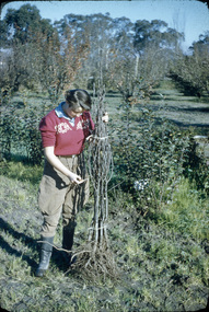 University of Melbourne, Burnley Campus Archives
Album - Colour slides, Burnley Views, 1956-1969
Contributor: T.H. KneenBox of 47 slides, some labelled. (1) "Marjorie Hall 1st Year Student June '56 No. 1872." Working with fruit tree stock. (2) "Orchard June 1956 No. 1710." 2 men and a tractor.(3) "Camp 1957." Wilson's Promontory. (4) View of Drive No. 1677." C. 1958 (5) "GenView No. 1771." (6) "Burnley Gardens Entrance 4.4.58 N0. 1672." (7) "Wilson's Promontory Lilly Pilly Gully Nov 1960." (8) Dec '62." (9) "Dec '62." Kneen child. (10) Luffmann Ponds "Aut. 1962." (11) Grevillea Sep 1963. (12) Sep 1963.Reflection of Crack Willow in Luffmann Ponds. (13) Sep 1963. Orchard blossom. (14) View of Administration Building at sunset Aug 1964. (15) Rose 'Heat Wave.' May 1965. (16) Kneen child sitting under a tree May 1966. (17) 'Department of Agriculture Burnley Gardens' sign May 1966. (18) Administration Building May 1966. (19) Plant Science Block May 1966. ((20) Wintersweet August 1966.(Actually appears to be Witch Hazel Hamamelis mollis.) (21) Student on tractor in the Orchard October 1966. (22) Garden view, view of Principal's Residence through blossom trees October 1966. (23) Students walking through the Gardens October 1966. (24) "Leaf Cuttings Rex begonia 2 October 1966. (25) Emily Gibson beds October 1966. (26) Principal's Residence in a garden view October 1966. (27) Garden view looking towards the Principal's Residence and the Shady Garden October 1966. (28) Drive looking towards the Administration Building from the Plant Research Institute. (29) Kneen child (not Burnley?) (30) Unveiling of Burnley Horticultural College plaque commemorating 75 years, 1891-1966 - Eric Littlejohn, ?, T.H. Kneen. Includes key to Pavilion 1969. (31) "Rose Pruning Demo - Canteen." July 1969. (32, 33) "Rose Pruning Demo 1969." July 1969. (34) "Plant Science Block & College." July 1969. (35) Plant Science Block 6/69." July 1969. (36) "Burnley Gardens 6/69." looking towards Dairy and Yarra Boulevard (37) "Pond No. 1717." (38) "Pond 1748." Kneen children playing by the Luffmann Ponds, Oak tree behind.. (39) Ginkgo leaves June 1967. (42) ? (43) Erithyna caffra in flower (removed 2016) December 1966. ((44) Administration Building and Nursery from PRI." (45) Pelargoniums. (46) Azalea mollis (47) Pelargonium foreground, geranium background.marjorie hall, students, fruit trees, orchard, tractor, wilson's promontory, burnley gardens, entrance, drive, garden view, luffmann ponds, grevillea, rose, kneen family, sign, wintersweet, plant science block, administration building, students working outside, principals residence, plaque, rose pruning demonstrations, ginkgo, pelargoniums, erythryna -
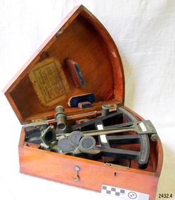 Flagstaff Hill Maritime Museum and Village
Instrument - Octant, mid 1800's
An Octant is a doubly reflecting navigation instrument used primarily by sailors to measure the angular distance between two visible objects and was a forerunner of the sextant. The name comes from the Latin octo, or "one-eighth of a circle," for the Octan'ts arc which spans 45°, or one-eighth of a circle. The primary use of an Octant is to measure the angle between an astronomical object and the horizon for celestial navigation. The estimation of this angle, is known as sighting or shooting the object, or taking a sight. The angle, and the time when it was measured, can be used to calculate a position line on a nautical chart (latitude), for example, sighting the Sun at noon or Polaris at night (in the Northern Hemisphere) gives an angle by which the latitude can then be estimated. Sighting the height of a landmark on land can also give a measure of distance. This fine octant once belonged to Captain Farquhar Chisholm and was donated by his granddaughter, Margaret Ruth Greer (nee Chisholm, born 1914). The label inside the Octant's box reads “Thomas L. Ainsley, Instrument Maker … etc”. Farquhar Chisholm was born in 1832 in Inverness, Scotland. He regularly sailed on perilous voyages between Quebec, Canada and the Baltic ports of Europe. In 1854 he migrated to Australia during the Gold Rush, to a place called Fiery Creek (near Beaufort Victoria) where he was fairly successful in his quest for gold. In the years of the Great Gold Rush, it was said that there were over 40,000 diggers in the goldfields of the Beaufort area! In 1857 having made sufficient money, he hired another crew and returned to Clachnacuddin, Inverness shire, Scotland and in that same year, he studied and obtained his Master Mariner Certificate (which would have included the use of an octant for navigation). He was appointed to Mr George (or James) Walker, as commander of his sailing ship, the 3-masted ELIZABETH, built 1859 and known as “The Walker barque”. In 1870 he married, then in 1887 returned to Australia with his wife and children (Kenneth Chisholm (1871), Mary Bremner Chisholm (1873), Margaret Hood Chisholm (1874), Farquhar Chisholm (1878)). They arrived in Port Melbourne, Victoria and sadly, only six weeks after landing, his wife Caroline passed away (in Geelong,1888). In 1900 Capt. Chisholm lived in Camperdown (Victoria) and not long after this his daughter Margaret died of consumption. In his later years, he went to live in the manse of St. Paul’s Presbyterian Church, Wangaratta, with his son, Rev. Farquhar Chisholm. He died there on Sat, 23rd March 1912, 80 years old. He was known as “… quiet, unobtrusive and competent, respected by all with whom he came in contact”. Some other members of Captain Chisholm’s family are; his older son Kenneth Chisholm, who was a contractor in Camperdown; a nephew Donald Macintosh (of 23 Douglas Row, Inverness); a grandson Brian Jones (son of Caroline Belle-Jones nee Chisholm, who lived in Camperdown in the earlier part of her life).The octant, the forerunner of the sextant, was a significant step in providing accuracy of a sailors latitude position at sea & his vessels distance from land when taking sightings of land-based landmarks.Octant, once belonging to Captain Farquhar Chisholm. Wedge shape (the size of an eighth of a circle), made of wood, glass and metal. Used in the 1880s. Maker’s name across centre “L. SIMON - - - SHIELDS”. Three (3) light filtering, coloured glass shades. Two (2) eyepieces. Scale attached for measuring angles. Label inside the fitted, wedge-shaped case "Thomas L. Ainsley, Optician"Label inside case "Thomas L. Ainsley, Optician" Maker’s name across centre “L. SIMON - - - SHIELDS”.flagstaff hill, warrnambool, shipwrecked-coast, flagstaff-hill, flagstaff-hill-maritime-museum, maritime-museum, shipwreck-coast, flagstaff-hill-maritime-village, maritime navigation, navigation instrument, migration, captain chisholm, farquhar chisholm, sailing ship, the elizabeths, thomas l. ainsley, l. simons, shields england, octant, john hadley, chisholm -
 Eltham District Historical Society Inc
Photograph - Digital Photograph, Alan King, St Margaret's Anglican Church, Pitt Street, Eltham, 30 January 2008
St Margaret’s Church of England was officially opened on December 12, 1861. It is the oldest intact church building in Eltham. At the time it was known as Christ Church until its consecration in 1871, when it was completely free of debt (£1,700 for the church and parsonage) despite the district’s poverty. This was largely due to the free labour and materials, including locally made bricks donated by local artisans and others. The church is historically significant because it is the oldest church in the former Shire of Eltham and has associations with the philanthropist and founder of Brighton, Henry Dendy (who donated the land on which the church is built), the architect Nathaniel Billing and the prominent local builder, George Stebbing. The church is architecturally and aesthetically significant because it is constructed in the Gothic Revival style with several stained-glass windows of various dates and is also a very early use of polychromatic brickwork in Victoria. Billing was one of the first Melbourne architects to employ polychromatic brickwork and an important early architect. The rear wall was intended to be temporary. A major feature of the design is the large buttresses with long, steeply graded upper faces. The overall design is well proportioned with the surface brick patterns relieving an otherwise austere design. The church is spiritually and socially significant because it has been an important place of worship for the people of Eltham for almost 150 years. The land on which the buildings stand was donated by Henry Dendy. Dendy arrived in Melbourne in 1841 after purchasing in England eight square miles at Brighton under the system of "special surveys". After this land passed out of his hands, Dendy moved about Victoria, visited England, then returned to settle in Eltham where he purchased a flour mill. Dendy chaired the meeting held in 1860 “for the purpose of devising such means as may be expedient for the establishment of a Church of England in the township of Eltham”. He became chairman and treasurer of the church committee. Unlike the establishment of many early churches in Victoria where a vicar was appointed to a parish and later a permanent church was constructed, the population at Eltham initiated action to build a church. The nearest church at that time was at Heidelberg and the Eltham settlement was part of the parish of St Johns Heidelberg. Isolation and the tedious, time consuming journey between Heidelberg and Eltham resulted in the Eltham community taking its own action. The original vicarage (Dendy House) at the rear of the church is also an important part of the cultural significance of this place because it is connected to the church and the development of the Eltham area. Together, the church and the vicarage are aesthetically significant because they form a significant streetscape feature. The mud-brick community hall designed by Robert Marshall was added in 1978. In 2014 the original temporary rear wall was removed as part of a modern extension designed by Architects Atelier Wagner and constructed by Conrad Construction and Management. Covered under Heritage Overlay, Nillumbik Planning Scheme. National Trust of Australia (Victoria) State significance Victorian Heritage Published: Nillumbik Now and Then / Marguerite Marshall 2008; photographs Alan King with Marguerite Marshall.; p67This collection of almost 130 photos about places and people within the Shire of Nillumbik, an urban and rural municipality in Melbourne's north, contributes to an understanding of the history of the Shire. Published in 2008 immediately prior to the Black Saturday bushfires of February 7, 2009, it documents sites that were impacted, and in some cases destroyed by the fires. It includes photographs taken especially for the publication, creating a unique time capsule representing the Shire in the early 21st century. It remains the most recent comprehenesive publication devoted to the Shire's history connecting local residents to the past. nillumbik now and then (marshall-king) collection, eltham, st margaret's anglican church, st margaret's church, christ church -
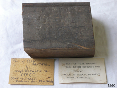 Flagstaff Hill Maritime Museum and Village
Souvenir - Wood Sample, Alexander Stephen and Sons, 1869
This teak wood sample was part of a handrail from the wreck of the ship Otago. The Otago 1869-1931 The iron-hulled 3-masted barque Otago was built in Glasgow by Alexander Stephen & Sons Ltd, Kelvinhaugh, as a merchant ship and launched in 1869. The vessel changed hands several times in the late 19th century after being sold to an Australian firm in 1871. During one of its voyages, the captain died while the ship was in port at Bangkok. Marine author Joseph Conrad was on board and, being a qualified captain, he took command and continued the journey to Sydney and Mauritius. It was the only ship he ever commanded. In 1903 the Melbourne shipping company Huddart, Parko & Co., purchased the Otago and converted it to serve as a coal hulk for use in Sydney. The Otago was later sent to Hobart, Tasmania, where it continued as a hulk until 1931. It was sold for scrap and eventually abandoned on the banks of the Derwent River at a place now known as Otago Bay, opposite Conrad Drive, Otago. The outline of the hull is still visible and a nearby plaque tells the story. There are other vessels also named Otago, one of them in the same year. Joseph Conrad (1857-1927): - Polish-born Joseph Conrad became a British subject in 1886. He was a renowned marine fiction writer and, for a short time, a mariner and Captain. As a 13-year-old boy, Joseph Conrad desired to be a sailor. At 19, he joined the British merchant marine, working in several roles. He eventually qualified as a captain but only served in this role once: from 1888 to 1889, when he commanded the barque Otago, taking over from the deceased captain and completing the ship’s journey from Sydney to Mauritius. In 1889 he began writing his first novel, Almayer’s Folly. He retired from life as a mariner in 1894, aged 36. Conrad’s affection for Australia and his visits to Australia from 1878 to 1982 were later commemorated by a plaque in Circular Quay, Sydney. Conrad continued as an author; some characters in his books were said to be inspired by his maritime experiences and the people he had met. By the end of his life, he had completed 19 novels, many stories, and essays, plus one incomplete novel, Suspense, which was finished and published posthumously. In 1924, Prime Minister Ramsay MacDonald offered Conrad a knighthood for his work but he declined. There is an 1882 sailing ship named the Joseph Conrad, after the author, that is now preserved at the Mystic Seaport Maritime Museum in the USA as part of the fleet of historic ships, used as an exhibit and a training ship. The Danish square-rigged training ship was originally named Georg Stage but was renamed by marine author Alan Villiers when he bought It in 1934. The wood sample from the Otago is significant for its association with renowned marine author Joseph Conrad, who had once commanded the vessel; it was his only command as Captain and was known as Joseph Conrad's Otago. The maritime connection with Conrad extends to items in the collection, including some of his maritime novels based on his first-hand knowledge, a wooden ship model of a ship named after him, and a navigation chart of Otago Harbour. The sample of teak is significant as an example of materials used in the construction of the 1869 iron-hulled sailing ship, built in Glasgow, Scotland, specifically for use to sail across the world with cargo to trade between the colonies including Australian ports. Wood sample; a rectangular section of a teak wood handrail that has a bead planed along one side. Two cards with the sample have inscriptions, one handwritten and one typed. The sample is from the wreck of the barque Otago, once under the command of Captain Joseph Conrad. Handwritten card: "PART OF TEAK HANDRAIL / from / Joseph CONRAD'S ship / OTAGO / (HULK at RISDON, DERWENT River, TASMANIA) Typed card: "PART OF THE TEAK HANDRAIL / FROM JOSEPH CONRAD'S SHIP / "OTAGO" / (HILK AT RISDON, DERWENT / RIVER, TASMANIA)"flagstaff hill, flagstaff hill maritime museum and village, warrnambool, maritime museum, maritime village, great ocean road, shipwreck coast, joseph conrad, joseph conrad's ship, captain joseph conrad, otago, barque otago, merchant ship, cargo ship, hulk, 1869 ship, iron hull, sailing ship, handrail, fitting, souvenir, wood sample, teak, new zealand, sydney, newcastle, tasmania, hobart, derwent river, otago harbour, otago bay, conrad drive, 19th century, mauritius, marine author, marine novel, alex villiers, georg stage -
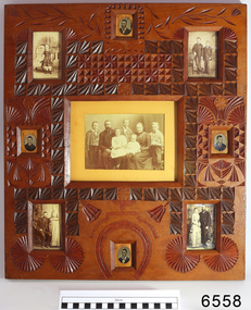 Flagstaff Hill Maritime Museum and Village
Photograph - Portraits, c. 1904
Ann Dale (nee Lees) was given this frame by her younger brother Thomas Chamberlain Lees, who was eighteen at that time. Thomas was the youngest son and seventh child of Lees and Sarah (nee Chamberlain) Lees. Ann loved her little brother’s artistic talents, which are demonstrated in this frame he designed and carefully carved for her. Thomas had cleverly finished the back with timber pieces around the images, and a section of a 1904 calendar. His “GOOD LUCK” is below the image of Ann, her husband Ellis Dale and their five children, c 1900. Sadly, Thomas died in 1911, aged 25. Ellis Dale’s father, William, was a quarryman who sailed from Yorkshire to Australia in 1852. He later bought land for Dale’s Quarries on the edge of Warrnambool in the area of Dale and Aberline roads. From the age of about eleven, Ellis and his brother worked in the quarry beside their father. In 1890 Ellis Dale married Ann Lees. Ann had lived nearby at Wangoom with her parents, Lees and Sarah Lees, who had had her photograph taken when she was a little girl, wearing her black dress. Ellis built a bluestone cottage for himself and Ann on his father’s land in Dales Road. He later added weatherboard rooms, and they named their finished home “Latrigg”. Early in their marriage Ellis recycled some empty dynamite boxes from their quarry to build a cupboard with drawers for Ann’s flat irons and other ironing equipment. The cupboard was used by future generations until recently, when Ann’s granddaughter, Betty Stone, donated it as part of the Chamberlain Dale Lees Collection. It is now in the kitchen of the Port Medical Office. Chamberlain Dale Lees family – local Colonial Pioneers Centre: Ellis Dale and Ann (nee Lees) and their five children - c 1900. Sons lvor William, Robert Ellis, Alfred John, and daughters - Elsie Mary Dale, and Daisy Elvena Dale. Top Left: Ann Lees - c 1868, (the little girl in the black dress) Top Right: William Dale Jnr. and Ellis Dale - c 1871 Lower Left: Ellis Dale and Ann (nee Lees), married 22 Jan. 1890 Lower Right: William Dale Jnr. and Agnes (nee Gillies), married 1883 Oval Photographs: unidentified but presumed to be family members [NB Spelling of Ann Dale – The spelling of Ann’s name has been confirmed by Betty Stone as being “Ann” (Not Anne), by phone conversation with Flagstaff Hill Maritime Village, K P 14th April 2014] (Note: For additional information please refer to Betty Stone’s book “Pioneers and Places - A History of three Warrnambool Pioneering Families” ie. Chamberlain, Dale and Lees Families)This item is associated with the families of Chamberlain, Dale and Lees. These families are listed in the "Pioneers' Register" for Warrnambool Township and Shire, 1835-1900, published by A.I.G.S. Warrnambool Branch. The handmade frame is a unique example of clever craftsmanship and carving skills used by early pioneers with limited access to materials.Family photographs, nine, set into carved, solid wood frame, stained and lacquered. Carving includes leaves, flowers, a horseshoe and a ribbon with the words "GOOD LUCK" Photographs are of the Lees family of Wangoom, from the 'Chamberlain Dale Lees Collection’ Made by Thomas Lees for his sister, Ann. The little girl with black boots on is Betty Stone's grandmother. The back of the frame has a London calendar dated 1904.Words in carved ribbon "GOOD LUCK" Calendar for the year 1904flagstaff hill, warrnambool, shipwrecked coast, flagstaff hill maritime museum, maritime museum, shipwreck coast, flagstaff hill maritime village, great ocean road, chamberlain, dale, lees, stone, betty stone, warrnambool pioneers, thomas lees, wangoom, ann dale, ellis dale, flagstaff hill, warrnambool, shipwrecked coast, flagstaff hill maritime museum, maritime museum, shipwreck coast, flagstaff hill maritime village, great ocean road, chamberlain, dale, lees, stone, betty stone, warrnambool pioneers, thomas lees, wangoom, ann dale, ellis dale, thomas chamberlain lees, handmade photograph frame, carved photograph frame, dynamite -
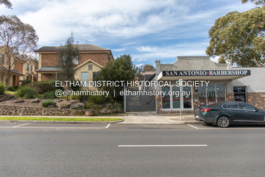 Eltham District Historical Society Inc
Photograph, Peter Pidgeon, 820 Main Road, Eltham, 2 Aug. 2022
In 1855 the first post office opened in Eltham under the management of Thomas Hunniford. It was a weatherboard building located on the eastern side of Main Road just south of Bridge Street. During the 1880s under the managment of Hunniford's daughter, Anne, the building was modernised with a new awning and upper facade. In late 1925 a new brick building was erected immediately next door (820 Main Road). Following the death of Anne Hunniford in December 1928, J.N Burgoyne was appointed Postmaster. The extension to the right of the store was erected in 1939 for a new telephone exchange adjacent to the store and post office. A continuous telephone service operated by Mr Burgoyne and his family commenced operation 18 November 1939. Approximately 70 extensions were routed through the new exchange, 40 of which were transferred from the Greensborough Exchange. Entry to the exchange was via a separate door on Main Road or via the shop. The public telephone was initially mounted on the wall but later moved to the street. The present store is a barber shop and it remains, though heavily modified, one of only three remaining shop fronts from the early 1900s in Eltham. Comparison photo: SEPP_0700, 00140, SEPP_0701, SEPP_0702 Part of a presentation by Peter Pidgeon to the Society, 13 August 2022 showcasing a series of photographs taken by John Henry Clark over the period 1895 to 1930. John Henry Clark was the youngest of three boys born to William Henry Clark (1823-1877) and Maria White (1843-1914). He and his brothers, William Charles Clark (1872-1945), Clement Kent Clark (1874-1912) operated a photography business (Clark Bros.) from 25 Thomas Street, Windsor near Prahran during the period c.1894 to 1914. Following death of Clement in September 1912 and their mother in 1914, the Clark Bros business appears to have dissolved, the premises demolished, and a new house was under construction in 1915. John set up business independently in 1914 operating out of 29 Moor Street, Fitzroy where he is registered in the 1914 and 1915 Electoral Rolls. By 1916 John had relocated to Eltham where he continued his practice as a photographer and took many of the early images around the district of Little Eltham. Around 1930 John changed professions and opened a small cobbler's shop in 1931 near the pond opposite Dalton Street adjacent to the Jarrold family cottage. He never married and continued his profession as a bootmaker from this little shop, maintaining a close relationship with Mrs Jarrold for the rest of their lives. His bootmaker shop remains today beside the Whitecloud cottage and is one of only three remaining shops in the area from the early 20th century.Comparative photo taken 2022 with one taken from same location over 100 years earlier by noted local photographer J.H. ClarkBorn Digitaleltham, j.h. clark photo (2022), main road, 820 main road, burgoyne store