Showing 811 items
matching maps and sections
-
 Bendigo Historical Society Inc.
Map - STRUGNELL COLLECTION: NEW CHUM LINE OF REEF, 5/4/01
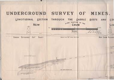
Map, Along portion of the New Chum Line, Underground Survey of Mines, Bendigo, Longitudinal Section through the Saddle Reefs and Centre Country. Eureka Extended Co's shaft, New Chum Railway Co's shaft. Surveyed under the supervision of H.Herman, B.C.E., F.G.S., Acting Government Geologist.H.S.Whitelowmap, bendigo, new chum line -
 Bendigo Historical Society Inc.
Map - STRUGNELL COLLECTION: HUSTLER'S LINE OF REEFS, BENDIGO, September 1913
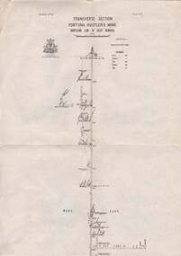
Map, Hustler's Line of Reefs, Fortuna Hustler's Mine, Bendigo, Transverse Section. Plate Mo.111(3).Bulletin No 33 Signed H.A.Whitelaw. Drawing shows the vertical shaft descending to over 2228 feet and appears to show samples of connecting horizontal shafts with their respective mineral contentsUnderground Survey Office, Bendigo.map, bendigo, fortuna hustler's mine -
 Port Melbourne Historical & Preservation Society
Flyer, Victorian Railways, Sandridge Rail Trail, 2005
Fold out flyer with black and white picture of train and three men on front cover. Back cover coloured image from Latrobe picture collection of park-like setting with steam train in background. Fold out section has history of railway, map, walk and ride descriptionstransport - railways, recreation, piers and wharves - station pier, piers and wharves - railway pier, hobson's bay railway company, melbourne and hobson's bay united railway company, montague street station, golden fleece hotel, st barnabas anglican church, north port station, lord raglan hotel -
 Ballarat Tramway Museum
Ephemera - Timetable/s, Osboldstone & Co Pty Ltd and Printers and Publishers Melbourne, "OSBA Tram Time Tables with Railway and Tramway Map, of Melbourne and Suburbs", 1920's
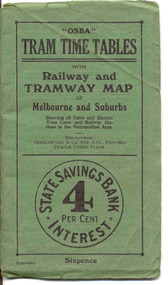
Yields information about the tram timetables applicable to Melbourne's trams, including cable and electric and demonstrates the spread of Melbourne's public transport system in the early 1920's.Forty Eight page printed book contained with oversize green heavy paper covers centre stapled with a coloured map glued into the rear cover of the book titled "OSBA Tram Time Tables with Railway and Tramway Map, of Melbourne and Suburbs". Published c1920 - shows Footscray system, Victoria St Flemington link, does not show Puckle St. Timetables details Fares, first and last cars for cable and electric lines, sections and other details of the various lines. Note page 44 and 45 cannot be accessed, paper not cut correctly during the printing process - leave as is. Map prepared by Gawler and Drummond Architects, shows in colour the cable routes, electric tramways, authorised tramways and railway lines. Municipalities shown in different colours. Map folded into 12 sections. Published by Osboldstone & Co Pty Ltd, Printers and Publishers, Temple Court Place, Melbourne. Price 6d. Full scan of document added as a pdf file 5/6/2019. map, timetables, melbourne, cable trams -
 Bendigo Military Museum
Map - Map Extract - Charterhouse of Mendip, John James Raisbeck, Unknown
Map extract showing the towns of Cheddar, Rodney Stoke, Westbury and a smaller town of Easton. The area depicted is part of Somerset, England. Map is hand drawn by J.J. Raisbeck date unknown. John James RAISBECK was born on 4 July 1880 at Christchurch New Zealand. He served 4 years (Citizen Military Force - CMF) in 9th Australian Light Horse Regiment in Central VIC with the rank 2nd Lieutenant. He was the first Australian appointed to the Survey Section RAE, on 16 April 1910, as a draughtsman which was his civilian profession, with the rank Warrant Officer, honorary 2nd Lieutenant. He was required to resign his commission in the CMF. He supervised the draughting work of the Section in Melbourne and was largely responsible for the mapping standards and specifications set in the production of the Cowes one-inch-to-one-mile military map, which became the enduring Australian standard. He was also responsible for supervising the printing of the maps by the Victorian Government Printer. He was appointed 2nd Lieutenant in the AIF Survey Corps draft on 6 December 1917 (from Melbourne) embarking for England on 22 December 17. He was attached to the Australian Corps Topographic Section in France from 21 April 1918 to 5 March 1919 serving as Second-in-Command and as Officer Commanding. He was promoted Lieutenant 15 October 1918, attending the AIF Survey School, Southampton in 1919, returning to Australia 23 June 1919, before his AIF appointment was terminated 17 July 1919. He went on to serve the Survey Section RAE and Australian Survey Corps, including in the Second World War, having been promoted Captain then Major and Officer Commanding Army Headquarters Cartographic Section until February 1940. He retired after 33 years of service to military survey, and after serving the Corps in two world wars, on 4 July 1943 with the retired rank Lieutenant-Colonel. He was the author of the article ‘A Short History of the Military Survey of Australia, 1907-1936’, published in The Australian Surveyor, Sept 1, 1937Map extract slightly larger than A4. Scale: One Inch to One and a half Mile. 1:31680, 9 x copiesSignature of "J.J. Raisbeck" bottom right-hand cornerroyal australian survey corps, rasvy, fortuna, army survey regiment, army svy regt, asr -
 Bendigo Historical Society Inc.
Document - FIRE BELL PLAN OF BENDIGO
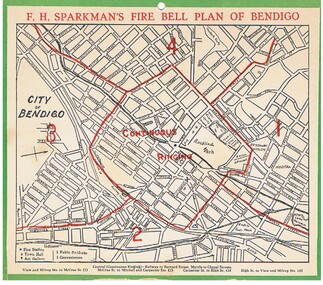
Plan Document. A Fire Bell Plan of Bendigo issued by F.H.Sparkman. A street map of Bendigo split up into a central zone plus four surrounding zones. It is probably the upper part of a calendar with the date section missing (torn off). F.H.Sparkman was a printer and a Mason. Date not shown but probably prior to 1950F.H.Sparkmanessential services, firefighting, fire bell plan of bendigo, fire bell plan, f.h.sparkman -
 Bendigo Historical Society Inc.
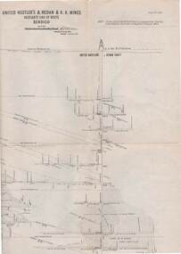
Map - UNITED HUSTLER'S & REDAN MINE - TRANSVERSE SECTIONS N & S OF SHAFT UNITED HUSTLER'S & REDAN MINE
Transverse Sections N & S of Shaft United Hustler's & Redan Mine on the Hustler's Line of Reef Bulletin No 33, Plate No XXX. Map shows some of the stone encountered on the levels and depth. Geological Survey of Victoria emblem and signed by H A Whitdan, Underground Survey Office Bendigo, September 1913.mining, parish map, united hustler's & redan mine, transverse sections n & s of shaft united hustler's & redan mine, hustler's line of reef -
 Bendigo Historical Society Inc.
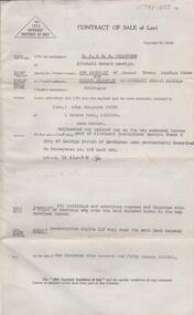
Document - H. A. & S. R. WILKINSON COLLECTION: CONTRACT OF SALE
Contract of sale of land dated 10th December, 1952 between Mrs. A. Baggaley & Mr. A. Baggaley (vendor) and Mrs. A. M. Smyth (purchaser). Property: land delineated and coloured red on the map endorsed hereon part of allotment 23 section 3B Parish of Sandhurst City of Bendigo, land described in conveyance No. 619 book 495, together with all buildings thereon with a right of carriage way over the land coloured brown on the map. Price: 1,950 pounds.organization, business, h.a. & s.r wilkinson real estate -
 Bendigo Historical Society Inc.
Map - K. K. MINE - TRANSVERSE SECTION K. K. MINE
Transverse Section of the K. K. Mine on the Hustler's Line of Reefs, Bulletin No 33, Plate No XXXII. Map shows the different levels and their depth. Also, the different types of stone encountered and geological features such as spurs and faults. Has drawing of the poppet legs at the top of the shaft and sill of shaft 773.56 ft above sea level. Map has Geological Survey of Victoria crest and signed by H S Whitelaw, Underground Survey Office Bendigo, September 1913. miners, fortuna hustler's mine, transverse section of k. k. mine, hustler's line of reefs, geological survey of victoria, h s whitelaw -
 Ballarat Tramway Museum
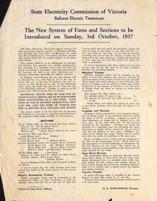
Poster, State Electricity Commission of Victoria (SECV), "The New System of Fares and Sections to be Introduced on Sunday, 3rd October 1937", Sep. 1937
... "The New System of Fares and Sections to be Introduced on... Sections ...Poster titled "The New System of Fares and Sections to be Introduced on Sunday, 3rd October 1937" produced by the SECV, Ballarat Electric Tramways. r. Provides information on the SEC control, the method of payment, sections, fares, weekly, school, scholars, luggage and parcel, View Point Services and Tourist Ticket. Signed by H. N. Hornabrook as Manager. Has printer's name, Tulloch and King in the bottom left-hand corner. See Reg. Item 2488, page 30 for another copy 8251 for the associated map/fare poster that was used in tramcars.Demonstrates the work the SEC undertook to provide information on the new ticket system of 1937 and yields information about the system.Poster quarto typeset printed sheet, Printed in blue ink on white paper with a semi gloss. Three copies held.trams, tramways, sec, fares, sections, tickets -
 Federation University Historical Collection
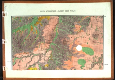
Map, Clunes, Mt Greenock, and Talbot Gold Fields, 1883, 1883
A geological plan of the Clunes, Mt Greenock, and Talbot Gold Fields in two parts. .1) This section of the map includes Talbot, Talbot water supply race, Mt Glasgow, Little Green Hill, Middle Hill, Mt Cameron, Ballarat Hill, Bakery Hill, Goodwoman Hill, Scandanavian Lead, Eglinton Swamp, McCallum's Creek, Tullaroop Creek, Dunach, Maryborough Railway, Middle Creek and includes many mines such as Rip Van Winkel, Union Extended, South Greenock, Nicholl's Freehold. .2) This section of the map includes McCallums, Clunes, Green Hill, Mt Beckworth, Mt Gap, Maryborough Reservoir, and includes mines such as Lothair, Bute, Clyde, Clunes Consols, London and Australian, Oriental,clunes, talbot, water supply, railway, geology -
Creswick Campus Historical Collection - University of Melbourne
Still Image, 1952
Subject: King Lake . 6 brown envelopes marked Run 3, 4, 7, 7a, 8, 9 containing c. 80 prints. 1 section of a topographical map marked State Aerial Survey. Stored in a brown cardboard file box marked King Lake Run No.3 - 9. (x9). Photos commissioned by Forests Commission Victoria.Aerial Photographs -
 Ballarat Tramway Museum
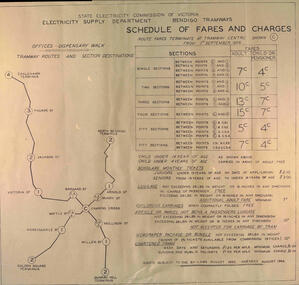
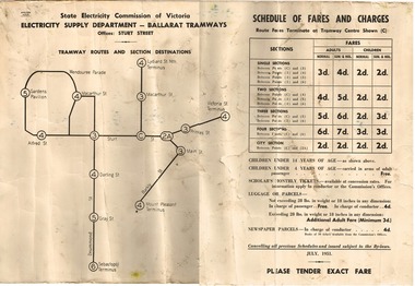
Poster - "Schedule of Fares and Charges - Bendigo", State Electricity Commission of Victoria (SECV), Aug. 1966
... Sections ...Drawing showing Bendigo Tramways (SEC) Fares, Charges, and Section Map. Also gives charges for Scholar's Monthly tickets, Luggage, Parcels, Newspapers and Chartered trams. Dated August 1966 Fares only in decimal currency. Titled - "Schedule of Fares and Charges (as from) - 1 September 1966". Shows offices as Dispensary Walk. Two copies held.Demonstrates the way the SEC advised passengers in Ballarat and Bendigo how the fare and charges systems worked and yielded information about the fare charges in force at the time. A copy was provided in each tram behind framed glass.Dye line print of a drawing on paper."BTPS" in blue ink on reartrams, tramways, bendigo, fares, sections, map -
 Federation University Historical Collection
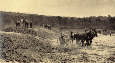
Book, Yallourn, 10/1962
In the foreword the Chairman and General Manager, W.H. Connolly, wrote: "Australia's progress since the Second World War has been remarkable - and nowhere more so than in Victoria. Although the smallest pf the mainland States, Victoria is today the most highly industrialised, the second most populous and the most rapidly developing State in the Commonwealth. Many factors have contributed to this growth, bu the one of greatest importance is the vast wealth of easily extractable brown coal in the Latrobe Valley which is the source of Victoria's electricity and a major part of its solid fuel. ... "White and green soft covered book of 34 pages with black & white and coloured illustrations. The book includes starts with an historical section, and includes information the open cut, Yallourn Power Station, Yallourn Briquette Works, the town, Morwell Open Cut, and includes a map of the Latrobe Valley Brown Coal resources.yallourn, connolly, open cut, power station, kernot, coal, briquette, lyle, monash, yallourn open cut, yallourn power station, yallourn briquette works, morwell open cut, hazelwood, brown coal, gippsland, horses, turning sod -
 Bendigo Historical Society Inc.
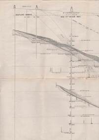
Map - STRUGNELL COLLECTION: HUSTLER'S LINE OF REEFS, BENDIGO, September 1913
Map, Hustler's Line of Reefs, Great Extended Hustler's Mine, Longitudinal Section Plate No X111 (13). Bulletin No 33 Signed H.A.Whitelaw Underground survey Office Bendigo September 1913 Drawing shows mine shaft to over 3454 feet deep and appears to show samples of connecting horizontal shaftsUnderground Survey Office, Bendigo.map, bendigo, great extended hustler's mine -
 Melbourne Tram Museum
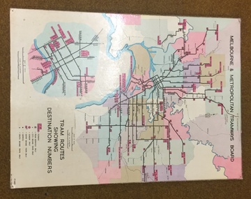
Map, Melbourne & Metropolitan Tramways Board, Del J. Chau, "Tram Routes showing destination numbers", 1972
Titled "Tram Routes showing destination numbers". Map dated 1972, showing routes with route numbers, including short working, names of main destinations, roads, railway stations and rail lines, municipalities, rivers, scales, city section in detail, depots and Sunday only services. In bottom right hand corner has number P.14431, Del J. Chau 1972. The original has been altered to show the Bundoora, La Trobe University and East Burwood lines and the change to Airport West. Type of map that was placed on the rear of the driver's doors of a W Class tramcar.Demonstrates a MMTB produced map used in trramcars.Full colour map or poster printed on heavy cardboard.trams, tramways, mmtb, map, routes -
 Bacchus Marsh & District Historical Society
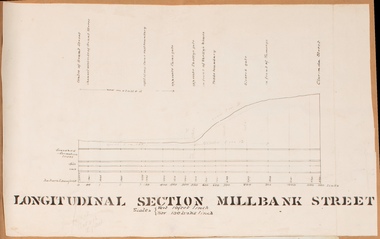
Drawing, Longitudinal Section Millbank Street Bacchus Marsh circa 1905
Millbank Street is a short street located close to the central business and shopping area of Bacchus Marsh. In the early 1900s works to improve the drainage of the street were discussed and planned by Bacchus Marsh Shire Council. This plan is most probably the plan discussed at a Shire Council meeting in April 1905. Single page plan showing a longitudinal section view of MIllbank Street running from Clarinda Street to Grant Street in Bacchus Marsh. The names of Millbank Street property owners, Cain, Shelley, Oliver and Ramsay are marked on this plan. Scale: Vertical 10 feet to 1 inch. Horizontal: 100 links to 1 inch Part of a set of maps which are pasted into a bound volume containing 76 maps or plans in total. High resolution digital image stored on BMDHS computer network. bacchus marsh victoria maps, millbank street bacchus marsh -
 Victorian Aboriginal Corporation for Languages
Periodical, John Barnes, The La Trobe journal, 2001
... maps ...The main focus of this edition is the extensive map collection of the State Library of Victoria. Contents: From the Editorial Chair Obituary: Estelle Canning Judith Scurfield The Map Section of the State Library Miles Lewis Maps for Building Research Thomas A. Darragh This Beautiful Work of Art?: Skene and Slight's Continental Australia Gerard Hayes Annotation: Ludwig Becker's ?First Camp from Duroadoo? Susan Ballyn Jean Baptiste Lehimas de Arrieta: The First Spanish Settler in Australia? Frances Thiele Recreating the Polite World: Shipboard Life of Nineteenth-Century Lady Travellers to Australia John Barnes Library Profile: Keith Murdochmaps, b&w illustrationsmaps, state library of victoria -
 Bacchus Marsh & District Historical Society
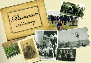
Book, Parwan: A History, 2010
Explores the history of the small farming community on the outskirts of Bacchus Marsh. It contains a plethora of fascinating details about the early years of this farming community from the 1830s until the early 2000s. There is a brief section at the beginning which looks at the history of the area prior to the colonial era. The book contains numerous sections about families and individual people who have lived in the Parwan area and includes many images of places and people. Citation: Parwan: A History by Dianne Van Leuvan. Published by Parwan History Group, Bacchus Marsh, Vic., 2010.Paperback printed book. 128 pages. with illustrations and photographs, some coloured. Includes facsimiles, maps, and index. Includes a separate folded sheet inside a pocket which has a reproduction of a map of the Parwan Parish in the County of Grant. On the reverse of this sheet are two reproductions. One is a land auction plan for February 1910 advertising the sale of portions of land from the Nerowie Estate. The other reproduction is a section of a map showing some of the blocks of land in the Nerowie Estate which has the heading, 'Nerowie Titles 1898'. A pocket inside the back cover contains a separate booklet which is an index, and two pages of 'Additional Information'.non-fictionExplores the history of the small farming community on the outskirts of Bacchus Marsh. It contains a plethora of fascinating details about the early years of this farming community from the 1830s until the early 2000s. There is a brief section at the beginning which looks at the history of the area prior to the colonial era. The book contains numerous sections about families and individual people who have lived in the Parwan area and includes many images of places and people. Citation: Parwan: A History by Dianne Van Leuvan. Published by Parwan History Group, Bacchus Marsh, Vic., 2010.parwan vic. history -
 Eltham District Historical Society Inc
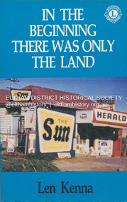
Book, Len Kenna, In the beginning there was only the land, 1988
A book, published as part of the Australian Bicentenary Celebrations on the history of the suburb of Bundoora. ... Includes photographs, maps and index. Local history of the outer Melbourne suburb of Bundoora, from the original Wurundjeri people through to its development as a thriving suburb in the 1980s ; section entitled "The Aborigines" (pp.14-21) discusses the traditional way of life of the Wurundjeri people prior to European settlement.bundoora, bundoora hall, hospitals, jane mckimmie, janefield, janefield church, john mckimmie, la trobe university, marvellous melbourne, mont park, mont park psychiatric hospital, plenty river, william shillinglaw, wurundjeri, yan yean reservoir -
 The Beechworth Burke Museum Research Collection
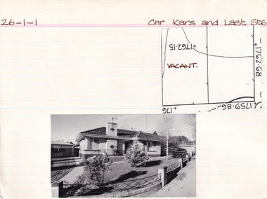
Card (Series) - Index Card, George Tibbits, Cnr Kars & Last Streets, Beechworth, 1976
George Tibbits, University of Melbourne. Faculty of Architecture, Building and Town & Regional PlanningIndex system that support the research for Beechworth : historical reconstruction / [by] George Tibbits ... [et al]Arranged by street names of BeechworthEach index card includes: street name and number of property, image of property, allotment and section number, property owners and dates of ownership, description of the property according to rate records, property floor plan with dimensions.beechworth, george tibbitsbeechworth, george tibbits -
 Bendigo Military Museum
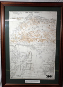
Map - MAP, NEW GUINEA FRAMED, 1941 onwards
Map of Western section of New Guinea. Black print on white background with mountain ridges in tan. Mounted with green border & brown wooden frame, glass front & white cardboard backing with wire hanging strap on back. Inset LHS bottom: A: Aroe Island B: KIA Island C: Taniimba IslandPrinted in black at top centre: “NEW GUINEA WESTERN’ Printed on border under map: “These escape maps were carried in the zip pockets of life jackets by fighter pilots in WW2. This map was presented to A.S.R. on the 12/7/79 by Councillor Ian McKenzie, Mayor of Eaglehawk, who served as a fighter pilot in 78th SQN in S.W. Pacific area during 1943-44.”map, new guinea, western, raaf -
 Ringwood and District Historical Society
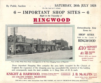
Flyer, Shop Sites Sale By Public Auction, Ringwood, Victoria - 1924
Folded double-sided brochure advertising six Ringwood shop sites for sale by Public Auction at 3pm, Saturday, July, 1924, with town photographs, location map, and summary of local features and services. Includes newspaper extract from the Real Estate and Property section from "Evening Sun", 6th June, 1924.Locality plan highlights shop sites for auction east of Pratt Street along Whitehorse Road. (Agents) Knight & Harwood, 315 Collins Street, Melbourne, Phones 10615, 10616 Central, in conjunction with J.B. McAlpin, Estate Agent, Opposite Railway Station, Ringwood, Phone Ringwood 7. -
 Bendigo Historical Society Inc.
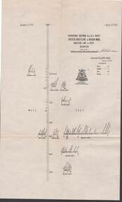
Map - STRUGNELL COLLECTION: UNITED HUSTLER'S & REDAN MINE, September 1913
Map, Transverse Sections N. & S. Of shaft, United Hustler's & Redan Mine, Hustler's Line of Reef, Bendigo. Plate No. XXX (30).Bulletin No 33 Signed H.A.Whitelaw. Drawing shows the vertical shaft descending to over 976 feet and appears to show samples of connecting horizontal shafts with their respective mineral contentsUnderground Survey Office, Bendigo.map, bendigo, hustler's & redan mine -
 Melbourne Tram Museum
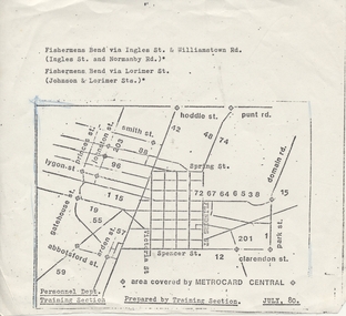
Drawing, Melbourne & Metropolitan Tramways Board (MMTB), "Area covered by MetroCard Central", Jul. 1980
Sheet (half foolscap?) photocopied, with a map of Melbourne tramway and bus routes drawn on it to show the extent of the ticket known as MetroCard Central. Dated July 1980. Prepared by the Training Section of the MMTB? For more details see http://www.robx1.net/victkt/pre1981/html/1980.htm - accessed 7/11/2018.trams, tramways, melbourne, tickets, mmtb, metrocard -
 Ballarat Tramway Museum
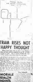
Document - Photocopy, Alan Bradley, "Tram Rises Not Happy Thought", 2003
Yields information through letters to the Editor about the impact of tram fare rises on Ballarat Residents, noting wages at the time.Photocopy, of part of the front page of The Courier, 16/6/1951, titled "Tram Rises Not Happy Thought". Gives the impact of the fare rises, doubling the weekly travel cost. Has a map showing the tramway routes and section destination to apply from 1/7/1951. The main problem was the cancellation of the concessional weekly ticket, revision of sections. Quotes Mr. T. A. Farr, Manager SEC Ballarat, notes differences in fares, penny surcharge on Sundays and holidays. On the front page are notes on the death and funeral arrangements of Ben Chifley.trams, tramways, public transport, fares, sec -
 Bendigo Historical Society Inc.
Map - STRUGNELL COLLECTION: UNITED HUSTLER'S & REDAN & K.K.MINES, September,1913
Map, United Hustler's & Redan & K.K.Mines, Hustler's Line of Reefs, Bendigo.Plat No.XXX1(31),. NOTE:- Plates 4,8,13,20,26,& 31 form a Longitudinal Section from Fortuna Hustler's to Hystler's Consols Mine. Bulletin 33.Signed H.A.Whitelaw. Drawing shows the vertical shafts descending to over 1932 feet and 1805 feet respectively .Underground Survey Office, Bendigo.map, bendigo, united hustler's, redan, k.k.mines -
 Ballarat Tramway Museum
Poster - Digital Image, State Electricity Commission of Victoria (SECV), "Schedule of Fares and Charges - July 1951", Jul. 1951
... Sections ...Demonstrates the way the SEC provided information to passengers about the fares and sections and other charges on the Ballarat Tramway system.Printed poster on heavy cartridge paper showing Ballarat Tramway (SEC) Fares, Charges, and Section Map. Also gives charges for Scholar's Monthly tickets, Luggage, Parcels and Newspapers. Dated July 1951. Digital image btm6322i2.pdf scanned in 2011 from the Bill Kingsley collection. Added 12-11-2015 trams, tramways, ballarat, fares, sections, map -
 Whitehorse Historical Society Inc.
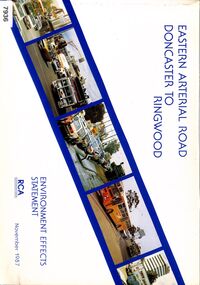
Book - Government Environment Effects Statement, Road Construction Authority (now part of VicRoads), Eastern Arterial Road - Doncaster to Ringwood, November 1987
The book covers the Environment Effects Statement for the Eastern Arterial Road Extension from Doncaster to Ringwood and the Ringwood Bypass. Aspects covered are development works, traffic affects, public transport, landscape and visual affects, noise, pedestrian/ bicycle access, lighting, air quality and construction affects. Includes maps, cross sections, photos.The book covers the Environment Effects Statement for the Eastern Arterial Road Extension from Doncaster to Ringwood and the Ringwood Bypass. Aspects covered are development works, traffic affects, public transport, landscape and visual affects, noise, pedestrian/ bicycle access, lighting, air quality and construction affects. Includes maps, cross sections, photos.non-fictionThe book covers the Environment Effects Statement for the Eastern Arterial Road Extension from Doncaster to Ringwood and the Ringwood Bypass. Aspects covered are development works, traffic affects, public transport, landscape and visual affects, noise, pedestrian/ bicycle access, lighting, air quality and construction affects. Includes maps, cross sections, photos.eastern freeway extension, eastern arterial road, mullum mullum creek, road construction, environmental impact -
 Melbourne Tram Museum
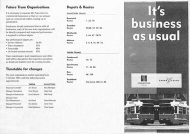
Pamphlet - PTC split, Public Transport Corporation (PTC), It's business as usual, 9/1997
Gives details of the split of the tram division of the Public Transport Corporation Vic to come into effect on 1-10-1997 into two business divisions - Yarra Trams and Swanston Trams. Includes a map showing which entity was to operate what section of Melbourne Trams. Prepared for employee information. Provides information on who would be the senior managers, a timetable, depots and routes to be operated and the logos that would be used.Yields information about the split of the Public Transport Corporation Tram division in preparation for the future privatisation. Pamphlet - photocopy titled Pamphlet - It's business as usual about the split up of the PTC to Swanston Trams and Yarra Trams. Two copies held.trams, tramways, yarra trams, swanston trams, ptc, managers, depots, public transport corporation