Showing 464 items
matching parcels
-
 Orbost & District Historical Society
framed photograph
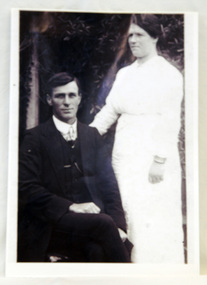
William Garnet Macalister's parents, Thomas Mewburn and Ruth Hannah Macalister, owned and operated "Orbost House". William Garnet Macalister was born at Bairnsdale in 1884 and at Sale, aged 72, in 1958. He operated a line of coaches conveying passengers and parcels from Orbost to Cabbage Tree Creek, Club Terrace, Cann River and surrounding districts. The service departed from Orbost on Wednesdays and from the Cann River Hotel on Fridays. He was also Orbost's first milkman. He married Ethel Roda SAYERS in 1909. ( Information from John Phillips) The Macalister family is associated with early Orbost.A copy of a b/w 1920 wedding photograph. It is in a wooden frame. The photo is of a groom, William Garnet Macalister, seated with his bride, Ethel, Roda Macalister, standing on his right an arm at his back.Handwritten on back - WILLIAM GARNET MACALISTER - SON OF THOMAS MEWBURN MACALISTER RUTH HANNAH MACALISTER OF ORBOST HOUSE B 1910 died 2003 (93 years old) ETHEL RODA MACALISTER (nee SAYERS)macalister-william macalister-ethel orbost-house -
 Ballarat Tramway Museum
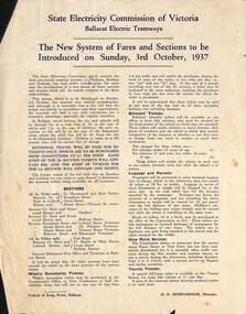
Poster, State Electricity Commission of Victoria (SECV), "The New System of Fares and Sections to be Introduced on Sunday, 3rd October 1937", Sep. 1937
Poster titled "The New System of Fares and Sections to be Introduced on Sunday, 3rd October 1937" produced by the SECV, Ballarat Electric Tramways. r. Provides information on the SEC control, the method of payment, sections, fares, weekly, school, scholars, luggage and parcel, View Point Services and Tourist Ticket. Signed by H. N. Hornabrook as Manager. Has printer's name, Tulloch and King in the bottom left-hand corner. See Reg. Item 2488, page 30 for another copy 8251 for the associated map/fare poster that was used in tramcars.Demonstrates the work the SEC undertook to provide information on the new ticket system of 1937 and yields information about the system.Poster quarto typeset printed sheet, Printed in blue ink on white paper with a semi gloss. Three copies held.trams, tramways, sec, fares, sections, tickets -
 Ballarat Tramway Museum
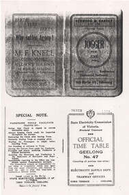
Document - Photocopy, State Electricity Commission of Victoria (SECV), "Official Time Table Geelong No. 47", March 1953
Photocopy of the March 1953 SEC Geelong Timetable, giving details of the fares, transfers, luggage or parcels, lost property, times of each tram on the Newtown, West Geelong, East Geelong, Chilwell, Eastern Park, Belmont and North lines. Has adverts for M F Knell chiropodist, Henwood and Dancey Printers, photos of the Captain and Coach and Secretary of the Geelong Football Club, a list of Premiership records, goals and Brownlow Medals. Note: Sheets are not in the same order as the printed versions due to the photocopying method. See items 5357 and 5629 for earlier versions. Yields information about the operation of the Geelong tramway system.Photocopy - 17 A4 sheets of the "Official Time Table Geelong No. 47" published March 1953tramways, trams, geelong, football, timetable, operations -
 Sunbury Family History and Heritage Society Inc.
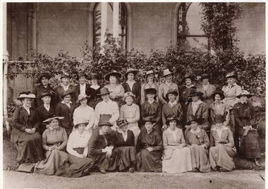
Photograph, Sunbury Red Cross 1915, 1915
The women in the photograph were members of the Sunbury Red Cross in 1915 and was taken during the years of World War 1 at 'Rupertswood Mansion' one of the Clarke family's homes. Over those four years the local people supported the war effort in many ways. School children knitted garments for the soldiers, Food parcels were sent away to the Front. Local events were held to raise money for the war effort. Many events supporting the war effort took place at Rupertswood and the Sunbury Red Cross frequently gathered at the mansion.On the Homefront members of the Sunbury community worked tirelessly to support the war effort and leading this movement was the local Red Cross.A non-digital sepia photograph with a narrow cream border of a group of well-dressed women posing for a photograph in front of a large mansion. A note on the back states that it is an original photograph which was taken in 1915. sunbury red cross, red cross, world war 1, rupertswood mansion, sir william clarke -
 Warrnambool and District Historical Society Inc.
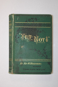
Book, Yet Not I, Late 19th century
The handwriting of the Skilbeck inscription suggests that it is of 19th century origin so the first owner of the book may have been Richard Skilbeck, a pioneer of the Koroit district who was at Yangery Grange farm from 1866 to 1916. The name on the printed label would be that of a Skilbeck descendant. This book is of antiquarian interest and is also kept because of its connection to the Skilbeck families from the Koroit area This is a hard cover book of 357 pages. It has a green cover with black and gold decorative panels and scrolls and gold lettering. The cover is somewhat stained and the spine is a little faded. The book has 33 chapters and advertisements at the back of the book for other books by the same author. There are decorative borders and scrolls at the beginning and end of each chapter. There are several black and white full-page illustrations, all protected by tissue paper. The inscription is handwritten in black ink and a piece of paper containing a printed name and address is affixed to the first page with adhesive tape. This label appears to come from an address on a parcel or newspaper. ‘Skilbeck Yangery’ ‘18 Mr Skilbeck Southern Cross Store Warrnambool’ richard skilbeck, yangery grange, yet not i -
 Ballarat Tramway Museum
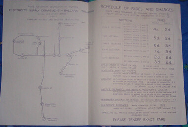
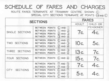
Poster, State Electricity Commission of Victoria (SECV), "Schedule of Fares and Charges - November 1955", Nov. 1955
Demonstrates the way the SEC advised passengers in Ballarat and Bendigo how the fare and charges systems worked and yielded information about the fare charges in force at the time. A copy was provided in each tram behind framed glass.Dyeline print of a drawing showing Ballarat Tramway (SEC) Fares, Charges, and Section Map. Also gives charges for Scholar's Monthly tickets, Luggage, Parcels, Newspapers and Chartered trams. Originally dated November 1955. All fares in shillings and pence. Titled - "Schedule of Fares and Charges - November 1955" See Reg Item 1731 and 4135 for the following versions. Note May have not been made in November 1955, some printed versions have been seen. Two additional copies found in depot collection 1/2011, added 5/1/2011. trams, tramways, ballarat, fares, sections, map -
 Ballarat Tramway Museum
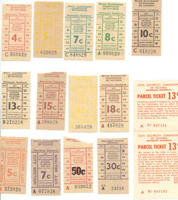
Ephemera - Ticket/s, Set of 14 mixed SEC and BTPS tickets donated to the BTM, late1960's to late 1970's
Set of 14 mixed SEC and BTPS tickets donated to the BTM as a set 1/7/2001. Tickets except for the BTPS ones have note been used. The image file shows the group of tickets. Tickets have not been individually numbered with the Registration Number, but can be identified by their ticket number and denomination. Most of the SEC tickets have the SEC logo "Electricity makes life easier! and small boy wrapped in a towel on the back, unless otherwise noted. All on off white (tending to a very light brown) paper unless otherwise noted with ticket numbers in black except for parcels ticket. 4c - C 355628 - red 5c - B 639028 - yellow 7c - C848828 - turquoise 8c - A939628 - green 10c - C818228 - black 13c - B279228 - black 15c - A388828 - off reddish brown 16c - A565428 - yellow 18c - A417828 - brown 5c - A372838 - City Section, orange, with tartan back 7c - A077828 - City Section, purple, with tartan back SEC Provincial Tramways 13c - Parcel Ticket - A 007101 (2 part ticket - see Reg. Item No. 1727 for further details) BTPS - 30c - A24310 - purple with BTPS information on back BTPS - 5c - over stamped with black 50c - A030052, plain back.trams, tramways, tickets, btps, secv, ballarat -
 Warrnambool and District Historical Society Inc.
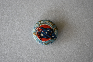
Badges, Australian Comfort Funds, circa 1916
These three badges all bear the phrase " For Our Fighting Men" and were sold to raise funds for Australian servicemen's comforts in World War One. The funds would have been used to send food and amenities parcels to those serving overseas, to provide assistance to those soldiers who had returned to Australia or were serving within Australia. The funds from the sale of these badges were directed to the Australian Comforts Fund which was an organisation formed in August 1916 from the amalgamation of the State groups formed to provide assistance to those serving in World War One. These badges are of interest as examples of those made and sold in Australia during World War One to provide comforts for Australian servicemen..1 Circular metal and enamel badge. The front features the Australian flag on a red background surrounded by a white annulus and a pale blue ring with text. There are rust marks on the surface.The reverse has a pin clip. .2 Identical to .1 but very discoloured and faded. .3 Circular metal and enamel badge. The front features a the head and shoulders of an Australian soldier in uniform with a slouch hat and a gun with bayonet fixed against a background of the Australian flag. Inside the outer rim of pale gold is a white ring with red text. There is a pin clip on the reverse. .1 FOR OUR FIGHTING MEN .2 Identical to .1 .3 OUR FIGHTING MEN AUSTRALIAN.COMFORTS. FUNDaustralian comforts fund -
 Eltham District Historical Society Inc
Photograph, Frank Stokes with daughters Dorothy (left) and Beryl (right) at Stokes Orchard, Nyora Road, Eltham, 1944, 1944
Frank Stokes first traveled to the district by train in 1944 to find land with the intention to establish an orchard. By chance he met Arthur Bird of Bird Orchard (bounded by Pitt Street, Eucalyptus Road and Wattle Grove) and they got talking over their common interest. Arthur put Frank up for the night and pointed out the land, part of Crown Allotment 15, Section 5, Parish of Nillumbik (CA15) somewhat diagonally opposite Bird Orchard. Frank bought the land and for the next two years would travel by train from Melbourne to Eltham every weekend establishing Stokes Orchard and building a home for his family, which they eventually moved into in 1946. In the mid 1970s the Shire of Eltham divided the orchard up into numerous rate-able parcel lots, which became affordable for Frank. As a consequence Stokes Orchard was turned into a housing development by Macquarie Builders and marketed as the Stokes Orchard Estate in two stages; Stage 1 encompassing Scarlet Ash Court, Ironbark Close and Peppermint Grove bounded by Nyora and Eucalyptus roads c.1976 and Stage 2 encompassing Stokes Place, Orchard Way, The Crest and The Lookout bound by Nyora and Diosma roads c.1979. The development of Orchard Way, The Crest and The Lookout did not proceed as planned due to the lack of the sewer along Diosma Road and so many of the proposed lots were incorporated into five-acre parcels instead.Representative of the orchard growing areas of ElthamDigital file only - Digitised by EDHS from a scrapbook (containing commercially printed photos of digital scans) on loan from Beryl Bradbury (nee Stokes), daughter of Frank Stokes.1944, beryl bradbury (nee stokes), beryl bradbury (nee stokes) collection, dorothy stokes, eltham, frank stokes, nyora road, stokes orchard -
 Bendigo Historical Society Inc.
Document - MINING REPORTS - GOLD ESCORTS
Two typed copies of Gold Escorts, Some Statistics. First one is South Australia - Mt. Alexander to Adelaide for 1852 and 1853. Mentioned are number, Escort Commdr, departure and arrival, days return, parcels, weight of gold and value in pounds. For Victoria - Ballarat to Melbourne, Geelong and Mount Alexander to Melbourne for 1852 mentioning date, Govt. Gold, Private Gold, ounces and value in pounds. Escort Loadings Sample - Castlemaine 1853, ounces and cash. Escort Loadings - All areas, 1860, number of ounces and total. Also mentioned are Total Escort Loadings, Victoria for each year 1851 to 1862 in ounces and dwts.document, gold, mining reports, mining reports, gold escorts, tolmer, alford, rose, stuart, lamb, cromie, wyndham, howell, malcolm blume, l j blake -
 Bendigo Historical Society Inc.
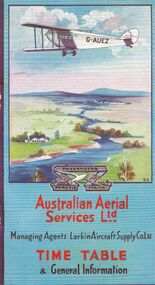
Document - BASIL WATSON COLLECTION: AUSTRALIAN FLIGHT TIMETABLES, a. & b. 1927/29; c. 1927?
Australian Flight Timetables,3 booklets: 1. Australian Aerial Services Ltd. booklet contains timetables, educational notes on aerial transport, first flight impressions, coach connections with airports, rules of the air, 1920's although no date on booklet. Aerial route map shows route from Melbourne to Hay, then to Adelaide, and east to Cootamundra. 2. AHS Timetable and general information booklet. Issued 1st March 1929, contains timetables, general information re flights, image of passengers 'emplaning' at Essendon Airport. 3. 'Fly There' booklet of timetable information and passenger fares and parcel rates. West Australian Airways.person, individual, basil watson -
 Ballarat Tramway Museum
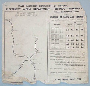
Poster, State Electricity Commission of Victoria (SECV), "Schedule of Fares and Charges - July 1951", Jul.1951
Demonstrates the way the SEC advised passengers in Ballarat and Bendigo how the fare and charges systems worked and yielded information about the fare charges in force at the time. A copy was provided in each tram behind framed glass.Printed sheet and mounted onto at least two other sheets of heavy blank paper to form a poster of a drawing showing Bendigo Tramways (SEC) Fares, Charges, and Section Map. Also gives charges for Scholar's Monthly tickets, Luggage, Parcels, Newspapers and Chartered trams. Fares in shillings and pence and decimal currency. Titled - "Schedule of Fares and Charges - July 1951". Shows offices as Hargreaves St. Has details of designer/draftsman and date "AVM/MM / 14/5/51" in top left hand corner. See images for digital photographs of the poster. Stored within a purpose made folder. In very poor order.trams, tramways, bendigo, fares, sections, map -
 Ballarat Tramway Museum
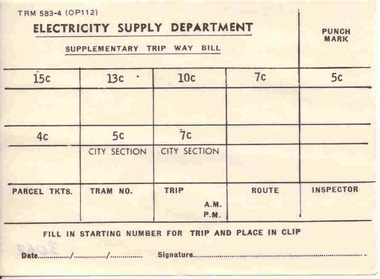
Document - Photocopy, State Electricity Commission of Victoria (SECV), "Supplementary Trip Way Bill", 1966
Yields information about the form used in Ballarat and Bendigo by the SEC to enabling ticket checking by Inspectors on the trams.Single sheet of paper titled "Supplementary Trip Way Bill", form No. TYE 583-4 (OP112), for filling in ticket starting numbers, for tickets from 8 ticket values through to 15c value. Also allows for parcel tickets, tram no, trip, route, inspector and punch marks. Has line for filling in date and signature at base of ticket. Used in late 1960's. Max. fare 15c Three copies held. See also Reg. item 68 and 279 for another sample - 1/- max value. See Fares in Ballarat – from Alan Bradley 11/4/2005 – appendix for Booktrams, tramways, secv rules, by laws, tickets, fares, ballarat, bendigo -
Glen Eira Historical Society
Plan - Nettalie
Land Victoria title documents vol 339 folio 763A and 764 relating to the property Nettalie on the corner of Balaclava and Orrong Rds. These documents detail the history of the land dealing relating to Nettalie and the neighbouring estate Harleston listed as parcels 209a and 209b. These dealing include grants of land, mortgages and conveyance (transfers). The documents include photocopies of handwritten notes of the title history date 1870; a partial copy of an instrument of conveyance dated 1863 and the original titles of the land owned at various times by William Noall, Alfred Shaw, Alfred Desailly and Sir Frederick Grimwade. Within the documents are various hand drawn and printed diagrams of the subdivisions.forsyth william, noall william, cutts william henry, shaw alfred, hailes george button, bakewell john, pascoe john randle, little william, fraser alexander, powell walter, whitney john, hodgeson richard, trollope william thomas, keep edward, blundell mary, carr john bonney, farie claud, fosberry john wallcott, davies john, brady michael, lloyd frederick, turner george, desailly alfred, grimwade frederick s sir, parish of prahran, county of bourke, caulfield north, st kilda east, balaclava road, orrong road, nettalie, netley house, harleston, melbourne grammar school, land subdivision, land sales, land titles, legal documents, homestead, schools, houses -
 Whitehorse Historical Society Inc.
Photograph - Playground, 27 Good Governs Rd Mitcham
Black and white photographs of a family of 3 at 27 Good Governs Rd with a paddock in the background Approximately 1969On rear of Photo: This was the paddock at the back of No 27 Good Governs Street at one stage Approx 1969 (Now no 12 Irvine St Development of 27 units0 Land was sold for $3.5 million in 2009 by estate of Mr Murray Jones who was the original owner of this parcel of land He purchased the remaining land from the mortgagor of Miss Linda Roberts. John Hay is the boy with his cousins from Ringwoodgood governs rd no 27, irvine st no 12, jones murray -
 Eltham District Historical Society Inc
Photograph, The Jelbart Barn, 93 Arthur Street, Eltham, 1972c
Owned at the time by architect, Ian Jelbart, the property had been in the Jelbart family since the 1940s; a 5560sqm secluded hilltop parcel in Eltham. When the manor house and its barn were built, Eltham was a rural community; Jelbart’s grandfather Ronald was a businessman whose poultry farm formed part of the family’s original 100ha holding. A portion would later be subdivided into residential lots to make way for new homes that would form the basis of the Woodridge Estate in the early 1970s. The Barn was developed as a residence by Ian Jelbart in the late 1960;'s. Handmade mud bricks were used in its construction. This is a view from The Barn looking towards the Manor HouseDigital file only; created from scan undertaken by EDHSarthur street, eltham, houses, jelbart barn, jelbart property, kinloch gardens, verandah, mud bricks, enclosure -
 Halls Gap & Grampians Historical Society
Photograph - B/W, C 1880
1880-1902 Land owned by Robert and Sarah Graham who owned a large portion of land best described as Upper Fyans Valley. At some time after 1880, they sold a parcel of the land under Sundial Peak to David Austin who built a slab hut. C1896, The land was sold to James and Amy Balmain which they named 'Bellfield' Amy was a daughter of John D/Alton who built the Stawell Water Supply System. Balmain purchased the vacant school cottage at Burnt Bridge and moved it to 'Bellfield' Over the next six years the house was enlarged to accommodate their growing family but sold in 1902 following the death of Amy Balmain.House with addition People leaving house by horse and carriage, people standing in groundsState Library Victoria, Rose's Australasian Views Victorian Series photographed and published by George Rose 123 Chapel St., Windsor, Victoriabuildings, houses, bellfield -
 Otway Districts Historical Society
Photograph, Crowes: Terminus of the railway line, 1911
The terminus of the railway, and the southern-most station on the Australian mainland, was Crowes, approximately 2 kilometres from Lavers Hill. The line ended at "The Black Stump". Crowes was designed as a fully functioning terminus and received a complete instalment of facilities. The site was laid out with three roads plus a dead end siding for a locomotive shed and ash pit. Goods sheds, a platform and livestock ramps catered for freight loadings, while on the north side was a station office, waiting room, parcels shed and passenger shelter. Three departmental residences were also provided. The resident Station Master was withdrawn in November 1916 and the station closed with the line on 10 December 1954.Photograph. Terminus of the Colac-Crowes at Crowes.crowes; terminus; "the black stump"; -
 Federation University Historical Collection
Plan, City of Ballarat (Part) (Ballaarat East), 08/05/1928
Crown Cadastral Plan showing Governement Roads, Crown Parcels, Dimensions, Crown grantees, dated of grants, etc in Ballarat East. The plan shows features such as Bakery Hill, Canadian Station, recreation reserves, timber reserves, Yarrowee Creek, Black Hill Reserve, Eureka Reserve and Garden, Orphan Asylum, Rifle Butts Reserve, Ballarat Woollen Mill, Ballarat Observatory, Sovereign Hill Recreation Reserve, Specimen Vale, Market Reserve, Cemetery WGS 84 Centroid 37 degrees 33' 55" S 143 degrees 52' 38" E E.W. Extent; 5 km N-S Extent; 4 kmmap, plan, ballarat east, ballarat woollen mill, ballarat railway line, ballarat railway station, eureka reserve, eureka cemetery, ballarat orphanage, russell square, bakery hill -
 Ballarat Tramway Museum
Poster, State Electricity Commission of Victoria (SECV), "Schedule of Fares and Charges - August 1966", Aug. 1966
Demonstrates an aspect of the SEC method of advising fares and sections to the travelling public. Also gave a small map that would have been useful to crews to explain to visitors where things were. Used in tramcars when trimmed. This poster made for the 1966 or second last fare increase. A similar arrangement used on Bendigo tramcars.Dyeline print of a drawing showing Ballarat Tramway (SEC) Fares, Charges, and Section Map. Also gives charges for Scholar's Monthly tickets, Luggage, Parcels, Newspapers and Chartered trams. Originally dated August 1965, amended August 1966. Note only shows decimal currency. Fares were applicable from 1/9/1966. Titled - "Schedule of Fares and Charges - August 1966" 2nd copy added 1/5/2001 - In good condition and images added as well. 3rd copy added 3-8-2006 - BTPS Cat. No. 608 - folded into four. For map - see blrtfcmap.jpg and for actual fare tables, btm705i1.jpg, btm705i2.jpg"BTPS 608" on outside of folded sheet in black ink and "Ballarat Tramway Preservation Society Catalogue No. 608" on top right hand corner of sheet.trams, tramways, ballarat, fares, sections, map -
 Ballarat Tramway Museum
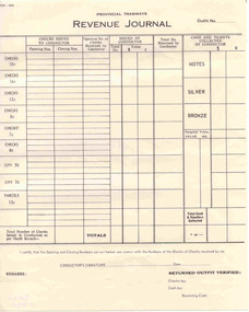
Document - Form/s, State Electricity Commission of Victoria (SECV), "Revenue Journal", 1969
Demonstrates aspects of the SEC tramway governance system in requiring sales of tickets to be monitored - balancing cash received against tickets issue, sold and returned. Issued to crews and then checked by clerks. The last Revenue Journal printed - fares as the system closed in 9/1971 in Ballarat.Printed form titled "Revenue Journal", for recording the value of tickets sold by Conductors. Headed - "Provincial Tramways". Has value of tickets up to 18c, parcel tickets of 13c. Gives the opening and closing number of tickets or checks issued to the conductor, check returned by conductor, total number issued, value, returned by conductor, cash returned, decimal currency, space for hospital vouchers and area where signed by conductor. Printed on off white paper. Has form number 554-200. Two copies held. Additional 7 copies added 8/1/2007. See Reg Item 3974 for a set of these for 11/3/1971.trams, tramways, tickets, accounting, revenue journal, conductors -
 Kew Historical Society Inc
Plan - Subdivision Plan, Jas R Mathers Son & McMillan, East Kew Tramway Estate, 1915
Pru Sanderson, in her groundbreaking ‘City of Kew Urban Conservation Study : Volume 2 - Development History’ (1988), summarised the periods of urban development and subdivisions of land in Kew. The periods that she identified included 1845-1880, 1880-1893, 1893-1921, 1921-1933, 1933-1943, and Post-War Development. These periods were selected as they represented periods of rapid growth or decline in urban development. An obvious starting point for Sanderson’s groupings involved population growth and the associated economic cycles. These cycles also highlighted urban expansion onto land that was predominantly rural, although in other cases it represented the decline and breakup of large estates. A number of the plans in the Kew Historical Society’s collection can also be found in other collections, such as those of the State Library of Victoria and the Boroondara Library Service. A number are however unique to the collection.The Kew Historical Society collection includes almost 100 subdivision plans pertaining to suburbs of the City of Melbourne. Most of these are of Kew, Kew East or Studley Park, although a smaller number are plans of Camberwell, Deepdene, Balwyn and Hawthorn. It is believed that the majority of the plans were gifted to the Society by persons connected with the real estate firm - J. R. Mathers and McMillan, 136 Cotham Road, Kew. The Plans in the collection are rarely in pristine form, being working plans on which the agent would write notes and record lots sold and the prices of these. The subdivision plans are historically significant examples of the growth of urban Melbourne from the beginning of the 20th Century up until the 1980s. A number of the plans are double-sided and often include a photograph on the reverse. A number of the latter are by noted photographers such as J.E. Barnes.The East Kew Tramway Estate was a subdivision of two separate parcels of land between Adeney Avenue and Normanby Road. The larger section included 54 lots facing Adeney Avenue, Argyle Road, and Campbell, Hunter and Wishart Streets. [Hunter and Wishart Streets were created as part of the subdivision.] A further 17 allotments faced Normanby Road, Hubert and Campbell Streets. [The name of Hubert Street was later to be changed to Cecil Street.] The promotion of the sale referred to the advantages of living between two tram routes, in High Street and Cotham Road. On the plan, quaintly drawn trams mark these routes. Also on the plan is the route of part of the Outer Circle [Railway] Line.east kew tramway estate, subdivision plans - east kew -
 Melbourne Tram Museum
Photograph - Set of 2 Black & White Photograph/s, Lee A Ratten, late 1930s
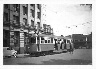
Set of two black and white photographs of tramcar 815 in Collins St at Spencer St. Tram 815 was one of 24 W5 class trams built by MMTB at Preston Workshops in 1937. Entered service Saturday 13 November 1937. In April 1984 converted to SW5. Currently stored at Newport Workshops. Was relocated to the site of the former Glenhuntly Post Office in Glenhuntly Road Feb. 2020. Photo shows tram at corner with Specer St station parcels building and VR building in background. Also shows building on corner which was used by State Saving Bank of Victoria. Destination shown as "Kew Depot" route number 47.trams, tramways, w5 class, collins st, spencer st, route 47, tram 815 -
 Eltham District Historical Society Inc
Photograph, Frank Stokes with his mother Florence (nee West) and children, Dorothy (left), David (centre) and Beryl (right), Stokes Orchard, Nyora Road, Eltham, c.1950, 1950c
Frank's mother Florence was visiting from England at the time. Frank Stokes first traveled to the district by train in 1944 to find land with the intention to establish an orchard. By chance he met Arthur Bird of Bird Orchard (bounded by Pitt Street, Eucalyptus Road and Wattle Grove) and they got talking over their common interest. Arthur put Frank up for the night and pointed out the land, part of Crown Allotment 15, Section 5, Parish of Nillumbik (CA15) somewhat diagonally opposite Bird Orchard. Frank bought the land and for the next two years would travel by train from Melbourne to Eltham every weekend establishing Stokes Orchard and building a home for his family, which they eventually moved into in 1946. In the mid 1970s the Shire of Eltham divided the orchard up into numerous rate-able parcel lots, which became affordable for Frank. As a consequence Stokes Orchard was turned into a housing development by Macquarie Builders and marketed as the Stokes Orchard Estate in two stages; Stage 1 encompassing Scarlet Ash Court, Ironbark Close and Peppermint Grove bounded by Nyora and Eucalyptus roads c.1976 and Stage 2 encompassing Stokes Place, Orchard Way, The Crest and The Lookout bound by Nyora and Diosma roads c.1979. The development of Orchard Way, The Crest and The Lookout did not proceed as planned due to the lack of the sewer along Diosma Road and so many of the proposed lots were incorporated into five-acre parcels instead.Representative of the orchard growing areas of ElthamDigital file only - Digitised by EDHS from a scrapbook (containing commercially printed photos of digital scans) on loan from Beryl Bradbury (nee Stokes), daughter of Frank Stokes.1950, beryl bradbury (nee stokes), beryl bradbury (nee stokes) collection, david stokes, dorothy stokes, eltham, flatbed truck, florence stokes (nee west), frank stokes, nyora road, stokes orchard -
 Eltham District Historical Society Inc
Photograph, The Stokes family home blanketed with snow, corner Nyora and Eucalyptus roads, Eltham, winter 1951, 1951
Taken from outside the family home on the southest corner of the intersection of Nyora Road and Pitt Street with Eucalyptus Road. Frank Stokes first traveled to the district by train in 1944 to find land with the intention to establish an orchard. By chance he met Arthur Bird of Bird Orchard (bounded by Pitt Street, Eucalyptus Road and Wattle Grove) and they got talking over their common interest. Arthur put Frank up for the night and pointed out the land, part of Crown Allotment 15, Section 5, Parish of Nillumbik (CA15) somewhat diagonally opposite Bird Orchard. Frank bought the land and for the next two years would travel by train from Melbourne to Eltham every weekend establishing Stokes Orchard and building a home for his family, which they eventually moved into in 1946. In the mid 1970s the Shire of Eltham divided the orchard up into numerous rate-able parcel lots, which became affordable for Frank. As a consequence Stokes Orchard was turned into a housing development by Macquarie Builders and marketed as the Stokes Orchard Estate in two stages; Stage 1 encompassing Scarlet Ash Court, Ironbark Close and Peppermint Grove bounded by Nyora and Eucalyptus roads c.1976 and Stage 2 encompassing Stokes Place, Orchard Way, The Crest and The Lookout bound by Nyora and Diosma roads c.1979. The development of Orchard Way, The Crest and The Lookout did not proceed as planned due to the lack of the sewer along Diosma Road and so many of the proposed lots were incorporated into five-acre parcels instead.Representative of the orchard growing areas of Eltham. One of the rare times it has snowed in ElthamDigital file only - Digitised by EDHS from a scrapbook (containing commercially printed photos of digital scans) on loan from Beryl Bradbury (nee Stokes), daughter of Frank Stokes.1951, beryl bradbury (nee stokes) collection, eltham, eucalyptus road, nyora road, snow, stokes family home -
 Eltham District Historical Society Inc
Photograph, The first houses in construction on the new Stokes Orchard Estate, July 1976, July 1976
Viewed from near the Stokes family home at 1 Nyora Road looking northeast across Ironbark Close to Scarlet Ash Court with Peppermint Grove in the distance. Frank Stokes first traveled to the district by train in 1944 to find land with the intention to establish an orchard. By chance he met Arthur Bird of Bird Orchard (bounded by Pitt Street, Eucalyptus Road and Wattle Grove) and they got talking over their common interest. Arthur put Frank up for the night and pointed out the land, part of Crown Allotment 15, Section 5, Parish of Nillumbik (CA15) somewhat diagonally opposite Bird Orchard. Frank bought the land and for the next two years would travel by train from Melbourne to Eltham every weekend establishing Stokes Orchard and building a home for his family, which they eventually moved into in 1946. In the mid 1970s the Shire of Eltham divided the orchard up into numerous rate-able parcel lots, which became affordable for Frank. As a consequence Stokes Orchard was turned into a housing development by Macquarie Builders and marketed as the Stokes Orchard Estate in two stages; Stage 1 encompassing Scarlet Ash Court, Ironbark Close and Peppermint Grove bounded by Nyora and Eucalyptus roads c.1976 and Stage 2 encompassing Stokes Place, Orchard Way, The Crest and The Lookout bound by Nyora and Diosma roads c.1979. The development of Orchard Way, The Crest and The Lookout did not proceed as planned due to the lack of the sewer along Diosma Road and so many of the proposed lots were incorporated into five-acre parcels instead.Housing development in Eltham as an extension to the Woodridge EstateDigital file only - Digitised by EDHS from a scrapbook (containing commercially printed photos of digital scans) on loan from Beryl Bradbury (nee Stokes), daughter of Frank Stokes.1976-07, beryl bradbury (nee stokes) collection, building construction, ironbark close, nyora road, peppermint grove, scarlet ash court, stokes orchard estate, houses -
 City of Moorabbin Historical Society (Operating the Box Cottage Museum)
Badge - WWI Red Cross Buttons
The International Committee of the Red Cross was formed in 1862. Initially its purpose was to try and find ways of overcoming the inadequacy of army medical services so as to alleviate the suffering of those wounded in armed conflict. Over time it has extended its work to include many forms of humanitarian aid in times of peace and war. The Australian Red Cross Society (ARCS) was formed just after the outbreak of the First World War in August 1914, originally as a branch of the British Red Cross. It is especially remembered in the provision of “comforts” for soldiers overseas. Enormous sums of money were raised, and thousands of women volunteers contributed their time by making vast quantities of clothing: socks, vests, mittens, mufflers, pyjamas and a variety of linen. Items were sent to headquarters located in the state capitals, often using government houses as depots, where, after being sorted and packed by yet more volunteers, they were sent to Britain or the front. The effect of this work for the recipients was to bring comfort in its truest sense, for a seemingly trivial gift of a bar of chocolate of a pair of dry socks could bring the most profound relief for a soldier on the Western Front. From the date of its inception until the armistice the ARCS dispatched 395,695 food parcels and 36,339 clothing parcels Between 1914 and 1918 more than £3,500,00 was collected and spent on Red Cross services to the Australian Forces and Empire Forces. During WW1 and WW2 Red Cross raised funds selling buttons.Early settlers in Moorabbin Shire held fundraising events for the support of Red Cross Victoria and made cakes and knitted socks, gloves and scarves for distribution to serving men and women Metal buttons with printing on themRed Crossred cross, fund raising buttons, wwi, wwii, french red cross, british red cross, market gardeners, early settlers, moorabbin shire, bentleigh, cheltenham, caulfield repatriation hospital -
 City of Moorabbin Historical Society (Operating the Box Cottage Museum)
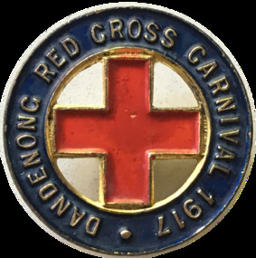
Badge - Red Cross - Springvale, 1917
The International Committee of the Red Cross was formed in 1862. Initially its purpose was to try and find ways of overcoming the inadequacy of army medical services so as to alleviate the suffering of those wounded in armed conflict. Over time it has extended its work to include many forms of humanitarian aid in times of peace and war. The Australian Red Cross Society (ARCS) was formed just after the outbreak of the First World War in August 1914, originally as a branch of the British Red Cross. It is especially remembered in the provision of “comforts” for soldiers overseas. Enormous sums of money were raised, and thousands of women volunteers contributed their time by making vast quantities of clothing: socks, vests, mittens, mufflers, pyjamas and a variety of linen. Items were sent to headquarters located in the state capitals, often using government houses as depots, where, after being sorted and packed by yet more volunteers, they were sent to Britain or the front. The effect of this work for the recipients was to bring comfort in its truest sense, for a seemingly trivial gift of a bar of chocolate of a pair of dry socks could bring the most profound relief for a soldier on the Western Front. From the date of its inception until the armistice the ARCS dispatched 395,695 food parcels and 36,339 clothing parcels Between 1914 and 1918 more than £3,500,00 was collected and spent on Red Cross services to the Australian Forces and Empire Forces. During WW1 and WW2 Red Cross raised funds selling buttons.This Carnival was an example of the support given to Red Cross by market gardeners, early settler families and schools in Moorabbin ShireDandenong Red Cross Carnival 1917red cross, dandenong, springvale, chelsea, dingley, keysborough -
 Ballarat Tramway Museum
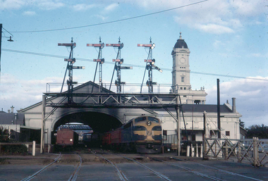
Photograph - Digital image, W. J. Llewelyn, late 1960s
Set of three colour digital images taken by W. J. Llewelyn of the Ballarat Railway Station at Lydiard St North. .1 - Possibly a S class loco on the Horsham / Dimboola/Serviceton St, about to leave Ballarat station during the late 1960's or early 1970's. A freight train is on platform 2. Note the Parcels Office and that the clock had not been fitted to the station building. .2 - S305? shunting at Ballarat station, during the late 1960's or early 1970's. Photos taken from the signal box. .3 - R766 on a special train at the station - late 1980's. Has the failed Melbourne - Canberra - Sydney tourism venture carriages at the rear.trams, tramways, railway station, level crossings, lydiard st north, steam locomotive -
 Melbourne Tram Museum
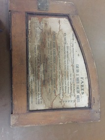
Functional object - Cable tram door frame piece/s, Melbourne Tramway & Omnibus Co. Limited, c1890
Fare board panel from Melbourne Cable tram saloon, from the inside or internal framing panels around a door. Made from soft wood, cut and assembled with wood screws, glued and then varnished. Part or panel that fitted over the end saloon window - fitted with hinges to allow access to the saloon door slide mechanism. Internal part of this part has a light colour finish on the rear. Details the fares for the Carlton / North Carlton routes. Also provides information on luggage and parcels. Issued by the MMTB. For detailed image of the panel, see the pdf file. Something not quite right when dB text opens it, open with a pdf reader to see the full text.trams, tramways, cable trams, components, fares, carlton, north carlton