Showing 870 items
matching road traffic
-
 Greensborough Historical Society
Newspaper Clipping, Diamond Valley Leader, Homes face bulldozer, 29/11/2017
Dozens of Greensborough homes will be bulldozed to make way for Victoria's largest ever transport project - The North East LinkNews article 1 page, black text and colour image .north east link, traffic, greensborough homes, compulsory acquisition -
 Greensborough Historical Society
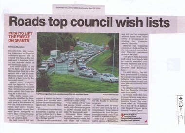
Newspaper Clipping, Diamond Valley Leader, Roads top council wish lists, 29/06/2016
Traffic issues in Banyule and surrounding areas are discussed.News clipping, black text and colour imagetraffic, north east link, banyule council, metropolitan ring road, banyule city council -
 Greensborough Historical Society
Photographic Slides, Police in Victoria, 1858-1930
Set of 7 slides depicting photographs of police from 1858 to 1930s. Includes gold escorts, traffic police in Melbourne, black trackers.7 photographic slides in Kodak box, plastic with yellow lid. Digital images entered seperately Each slide is marked with its subjectvictoria police, police -
 Greensborough Historical Society
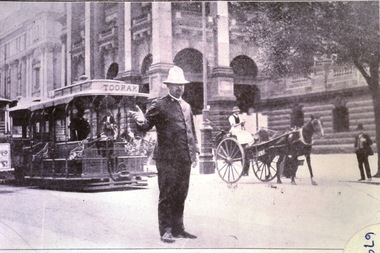
Photograph - Digital Image, Victorian Policeman on Point duty in Swanston Street 1930s, 1930s
Digital copy of one of 7 slides depicting photographs of police from 1858 to 1930s. This image is of an officer on traffic duty at the Melbourne Town Hall, Swanston Street, with the Toorak tram in background.Digital copy of black and white slide.victoria police, melbourne town hall -
 Glenelg Shire Council Cultural Collection
Newspaper - Newspaper Clipping - K. S. Anderson, c. 1964
K.S. Anderson CollectionNewspaper clippings - K.S. Anderson on threat of Melbourne to Port of Portland Port Authority; Port traffic sets another record; 1964 Portland's Year of Achievement.k s anderson collection -
Glenelg Shire Council Cultural Collection
Photograph, 1950-1960
Sourced from Casterton Town Hall former Shire of GlenelgBlack and white photo. Two bridges, side by side. One on left is part of unsealed road, the one on right is a wooden bridge. Kings Bridge Merino-Coleraine Rd.Front: 'Kings Bridge Merino-Coleraine Rd. Traffic detoured over temporary Bridge on Right' - handwritten, pen Back: Photographer's stamp - round, purple -
 Halls Gap & Grampians Historical Society
Photograph - B/W, C 1900
In early 1900, three Emmett brothers, with support from George Mason, set about following up a report of gold in the area. Confirmation of gold led to a gold rush in June 1900. Traffic from Ararat and Willaura passed Mason's Farm and it was on Mason's land that the first settlement, Ladysmith, sprang up.Road leading to Mt William goldfield 1900. George Mason's farmhouse on right hand side of road.access routes, roads, mining, ladysmith -
 Halls Gap & Grampians Historical Society
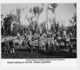
Photograph - Sepia, C 1900s
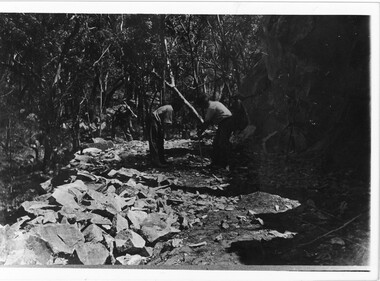
Photo depicts "road-making" approaching the Mount William gold fields. Because of the heavy traffic in the area during the very wet winter of 1900, low sections of the track became quagmires and road building was essential.Photo shows men with horses, carts, shovels etc. There are six horses in photo, three of them hitched up to carts. There are twenty-two men in total, some holding shovels etc.Photo has been laminated. "Title" appears at bottom of photo together with previous holder of photoaccess routes, roads, access routes, road building -
 Halls Gap & Grampians Historical Society
Photograph - B/W, C 1920s
Men have started to form the Mt Victory Road. Until the 1900's access to the Stoney Creek gorge was via a winding bridal jinker track. Increased traffic lead to much of this route being widened into what became known as Bluff Road. Within a few years the route was further improved and was officially named Mount Victory Road in 1930.Photo shows 3 men working with pick and shovel on roadPick and shovel Mt Victory Rdaccess routes, roads, access routes, road building -
 Eltham District Historical Society Inc
Negative - Photograph, Diamond Creek, Eltham. Old Diamond Street Bridge
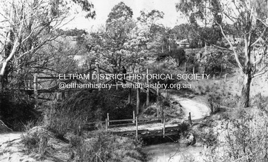
Copy of Rose Series Postcard P. 4314. (The Rose Stereograph Company) Shows two bridge crossings over the Diamond Creek in Diamond Street, Eltham. The upper pedestrian crossing provided continual access for foot traffic during times of flood. The railway came to Eltham in 1901, the Eltham Railway Station is visible in the distance as well as a wooden bodied Tait (Red Rattler) First Class train carriage. The Tait train was first introduced in 1910 as a steam locomotive hauled carriage and in 1919 electric motor carriages were introduced however the line to Heidelberg was not electrified till 1921 and to Eltham in April 1923. The Railway General Store on Main Road is visible beyond the station and was built by Luther Haley in 1902. It was the first shop in the present day shopping centre. It was later known as lloyd's stopre (1917-1920) followed by a succession of six other owners until purchased by Eric Staff in 1939. George Rose founded the Rose Stereograph Company in 1880 and was joined by Herbert (Bert) Cutts in the early 20th Century. The pair formed a lifetime working partnership and strong personal friendship. Assisted by George’s two sons, Herbert George and Walter, and later by Neil Cutts, the Rose Stereograph Company continued its operations for more than 140 years. The company was initially built on stereographs, but as cinema took over and stereographs fell out of fashion, the Rose Stereograph Company developed Australia’s first commercially viable photographic postcard business. Specialising in postcards of iconic historical moments and significant landmarks, The Rose Stereograph Company became a staple of the Australian travel industry.This photo forms part of a collection of photographs gathered by the Shire of Eltham for their centenary project book,"Pioneers and Painters: 100 years of the Shire of Eltham" by Alan Marshall (1971). The collection of over 500 images is held in partnership between Eltham District Historical Society and Yarra Plenty Regional Library (Eltham Library) and is now formally known as 'The Shire of Eltham Pioneers Photograph Collection.' It is significant in being the first community sourced collection representing the places and people of the Shire's first one hundred years.Digital image 4 x 5 inch B&W Negdiamond creek, diamond street bridge, eltham, eltham railway station, glass plate negative, lloyd's general store, postcard, railway station, railway store, rose series postcard, rose stereograph company, shire of eltham pioneers photograph collection, staffs general store, tait train, travel -
 Eltham District Historical Society Inc
Negative - Photograph, Construction of the new concrete bridge over the Diamond Creek on Main Road, Eltham, c.May 1926
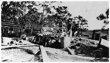
Construction of the new concrete bridge over the Diamond Creek on Main Road, Eltham, c.May 1926. Viewed from northern approach looking south east towards Eltham Park (Eltham Lower Park), showing the power lines that used to run in front of the park. The original long suspension bridge over the Diamond Creek on Main Road at Eltham collapsed during flooding of the Diamond Creek on October 13 and 14, 1923. The original bridge was built around 1840 for the coach road when Cobb & Co.'s coach was the only conveyance between Eltham and Melbourne. Widespread damage was done in Melbourne and surrounding areas by floods resulting from the overflow of the Yarra at many points along its banks. A temporary bridge rigged up was severely damaged by the flooding of the creek and was closed to vehicular traffic in April 1924. A new concrete bridge was constructed to replace it and by May 1926 all the concrete piles and abutments had been completed. The bridge was finally completed and opened for traffic in September 1926, almost three years after it initially collapsed.This photo forms part of a collection of photographs gathered by the Shire of Eltham for their centenary project book,"Pioneers and Painters: 100 years of the Shire of Eltham" by Alan Marshall (1971). The collection of over 500 images is held in partnership between Eltham District Historical Society and Yarra Plenty Regional Library (Eltham Library) and is now formally known as the 'The Shire of Eltham Pioneers Photograph Collection.' It is significant in being the first community sourced collection representing the places and people of the Shire's first one hundred years.Digital image 4 x 5 inch B&W Negshire of eltham pioneers photograph collection, bridge, bridge construction, cement mixer, diamond creek (creek), eltham, eltham lower park, eltham south, main road bridge -
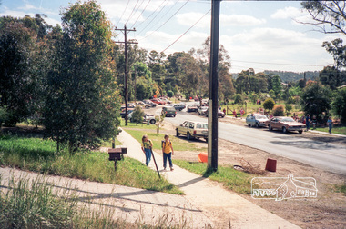
 Eltham District Historical Society Inc
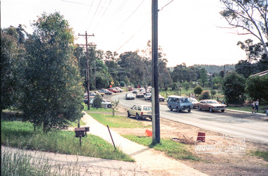
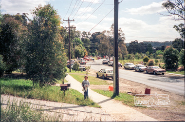
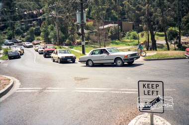
Photograph, School pick-up traffic from Eltham East Primary School, Grove Street, c.April 1987
Probably a Shire of Eltham investigation into traffic and parking at school pick-up timesRoll of 35mm colour negative film, 3 stripsKodak GA 100 5095shire of eltham, eltham east primary school, roads, grove street -
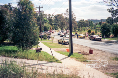
 Eltham District Historical Society Inc
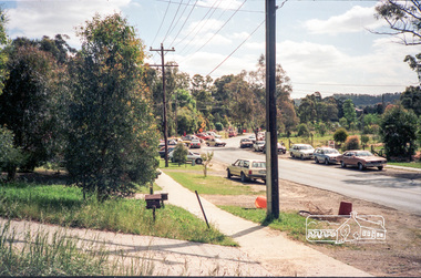
Photograph, School pick-up traffic from Eltham East Primary School, Grove Street, c.April 1987
Probably a Shire of Eltham investigation into traffic and parking at school pick-up timesRoll of 35mm colour negative film, 3 stripsKodak GA 100 5095shire of eltham, eltham east primary school, roads, grove street -
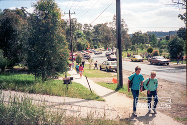
 Eltham District Historical Society Inc
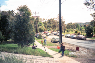
Photograph, School pick-up traffic from Eltham East Primary School, Grove Street, c.April 1987
Probably a Shire of Eltham investigation into traffic and parking at school pick-up timesRoll of 35mm colour negative film, 3 stripsKodak GA 100 5095shire of eltham, eltham east primary school, roads, grove street -
 Eltham District Historical Society Inc
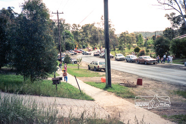
Photograph, School pick-up traffic from Eltham East Primary School, Grove Street, c.April 1987
Probably a Shire of Eltham investigation into traffic and parking at school pick-up timesRoll of 35mm colour negative film, 3 stripsKodak GA 100 5095shire of eltham, eltham east primary school, roads, grove street -
 Eltham District Historical Society Inc
Photograph, School pick-up traffic from Eltham East Primary School, Grove Street, c.April 1987
Probably a Shire of Eltham investigation into traffic and parking at school pick-up timesRoll of 35mm colour negative film, 3 stripsKodak GA 100 5095shire of eltham, eltham east primary school, roads, grove street -
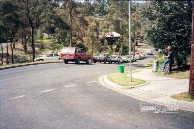 Eltham District Historical Society Inc
Photograph, School pick-up traffic from Eltham East Primary School, Beard Street, c.April 1987
Probably a Shire of Eltham investigation into traffic and parking at school pick-up times At the junction of Grove and Beard Streets viewed from Wycliffe CrescentRoll of 35mm colour negative film, 3 stripsKodak GA 100 5095shire of eltham, eltham east primary school, roads, grove street, beard street, wycliffe crescent -
 Eltham District Historical Society Inc
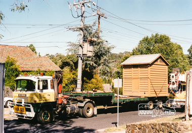
Photograph, Lock-up No. 17 arriving at the Local History Centre, 728 Main Road, Eltham, March 2001, March 2001
The portable lockup at Eltham is not original to the site. The date of construction is unknown, believed from the 1880s. It is a prefabricated design and each of the timber panels are individually numbered on the inside surfaces. It is amongst a large group of portable lockups, categorised as 'Portable Lock Up - Timber - Later' and also known as the "Casterton style", based on the only known plan for portable lock ups, built for the Casterton Police Station, in 1907. The later portables have been in use since the 1880s. It is not known how many lock ups of this type have been constructed in Victoria. At least 50 examples have been documented around the state. Of these, 42 are known to be extant. The original 1860s site lockup was a 2-cell bluestone construction. Some of the original bluestone remains. It was used in the 1970s as traffic island edging at the intersection of Main Road and Wattletree Road where it was painted white then later relocated back to this site in the 1980s to be used as edging for a driveway access off Main Road beside the former Police Residence where the Police Station originally stood. Evidence of some of this edging remains in place today leading to the replica Police Station. Other blocks were used to define the garden edging in the carpark at the rear of the residence.This lockup used to be located at the Police Station in Pryor Street and was then stored in Youth Road before being acquired for the Local History Centre 3 colour photographseltham, main road, police residence, local history centre, eltham district historical society, courthouse, youth road -
 Kiewa Valley Historical Society
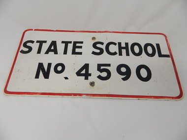
Sign - Bogong State School
Bogong State School opened in 1941 to provide an education for the employees of the State Electricity Commission of Victoria. The school had up to date equipment and received glowing reports from School inspectors. It closed c1986.Historical: The Bogong State School was opened for the children of S.E.C.V. workers who lived at Bogong in a remote part of north east Victoria. The nearest school would have been 14 miles away and over mountain roads subject to heavy construction traffic and extremes of climatic conditions. Metal sign painted white with thin red border and black block capital letters and numbers. There is a hole in the middle top and middle bottom of the sign."State School / No. 4590"state school. bogong. education. state electricity of victoria. kiewa hydro electric scheme. -
 Kiewa Valley Historical Society
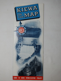
Map - Kiewa on the Map, Guide to Kiewa Hydro-Electric Project
Published by the SECV in 1950. They controlled the roads from Mt Beauty to the Bogong High Plains and all other roads within the Kiewa works area. The roads are not open to general tourist traffic. Conducted tours of the Kiewa area are operated by Eastern Road Lines Pty. Ltd., AlburyThe SECV constructed the KHES and controlled all roads within the Kiewa works area.Large colored map folded in half and then in 3. Front third is mostly blue and white with titles.. When opened the cover has black and white photos beside it with print and 'Please Note'. Also in the other half, a 'Road Map to Kiewa' showing the south eastern side of Australia, mostly yellow (the land) and blue (the sea). Inside the map is a close up map of "Ground Plan of Kiewa Hydro Electric Project' with a 'Key Map Showing Distances'.map of kiewa 1950, khes map -
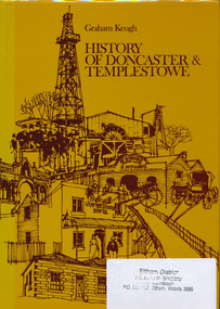 Eltham District Historical Society Inc
Book, City of Doncaster and Templestowe, History of Doncaster & Templestowe by Graham Keogh, 1975
History of the City of Doncaster and Templestowe, beginning with first settlers on Bulleen and Templestowe rivers, including gold seekers, general development 1900-1945, expansion, road problem, disaster of 1962, traffic problems, Warrandyte State Park, historical research. photos index466 p.ISBN 0959948716doncaster, templestowe, bulleen, warrandyte -
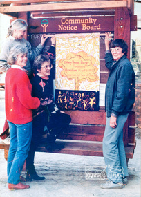 Eltham District Historical Society Inc
Photograph, Ron Grant, The Eltham Peace Group hanging the Hiroshima Day Banner on the Community Notice Board, Arthur Street, Eltham; Community Arts 1986 'As We Are' Banner Project Group, Hiroshima Day, 6 August 1986
Arthur Street, Eltham next to ANZ Bank The Hiroshima Day Banner was made by Jacky Talbot as part of the project. The women wanted to do something for Hiroshima Day and suggested that a workshop be set aside to make a banner. The artist was concerned about the remaining time scheduled for the project and spent several days "whipping" up the banner herself. For the artist this banner was to prove quite significant. The women hung it at the Community Notice Board on Hiroshima Day and were photographed by the local newspaper publicising the group and drawing wider community attention to the remembrance of the day. Although no new members joined the group from this activity, the artist felt that she was more fully accepted by the group afterwards. This banner has initiated a small group of women committed to peace. The artist has also continued to liaise and meet with the women as time permits. Future group plans include: making kimonos to wear when carrying the banner, participating in the Palm Sunday March, an observance of Hiroshima Day activity, which is yet to be decided, establishing contact with a sister-town in USA and USSR and supporting Eltham Council's stance as a Nuclear Free Zone. (The banner habits of the Eltham tribes : Eltham Shire "as we are" Community Banner Project report / by Jacky Talbot, Shire of Eltham, Feb. 1987, p46) Used in Shire of Eltham display at the Eltham Community Festival, 7 November 1987. Shire of Eltham Engineering Department Providing the resources to undertake • Survey, design, consultation • Road construction and maintenance • Bridge construction and maintenance • Street sweeping • Drain and pit cleaning • Traffic engineering installation and maintenance • Garbage collection • Tip management, land reclamation and beautification • Maintenance of community buildings • Provision of community and recreation facilitiesIllustrative of services provided by former Shire of ElthamColour photograph 20 x 29 cm mounted on green-painted chipboard 28 x 35.5 cm (string on back for hanging) Ref: 01842-0Title printed on label adhered to board below photograph (replaced June 2017)display panel, eltham festival, eltham peace banner, hiroshima day banner, infrastructure, shire of eltham, laurel eckersall, anne laurence, betty johnson, joan maclagan -
 Eltham District Historical Society Inc
Photograph, Old Bridge, Kaylock's Crossing, Brougham Street, Eltham, c.1895
Brougham Street was created in Josiah Holloway's 1851 subdivision of Little Eltham. It was one of several east-west streets shown on the subdivision plan as crossing the Diamond Creek. The western part was named Wellington Street on the subdivision plan but was later changed to conform with the name of the eastern part as acknowledgement of the continuity of the street. It is not known when the first bridge was constructed in Brougham Street however it was certainly mentioned at Council’s meeting of 2 June 1884 as being in a dangerous state of repair. This photo (c.1895) of an old bridge shows a very low-level simple log girder bridge crossing the creek at a right angle and so the approaches involved bends in the road alignment. This bridge was generally known as Kaylocks Bridge or Kaylock’s Crossing after the owner of the adjoining land. It was most likely built from around the mid-1850s, or a crossing of some fashion established as Richard George Kaylock, butcher of Little Eltham and his wife Emily Ann settled there in 1854. His property was in Wellington Street (now Brougham Street) and apparently extended across the Diamond Creek. The land on the western side of the creek was farmed, the house being on the eastern side. Kaylock's Bridge formed part of the original coach road to Eltham and in 1922 was described as an "old rustic bridge". Its low level and insubstantial construction made it susceptible to flood damage, necessitating frequent closures until repairs could be carried out. In September 1922, Council called for tenders for a new timber bridge to be constructed at Kaylock’s crossing. An engineering assessment carried out for the Council by Macleod Consulting at the time of the replacement suggested that the construction details indicate that it was in the 1900s, however this dating could possibly have been the result of numerous repairs undertaken over the years to flood damage. The tender was awarded to Mr Weller of Kangaroo Ground who commenced work in February 1923 on a higher-level timber trestle bridge. Work was slowed due to illness of the contractor and the accidental death of a man in March 1923 following the collapse of the bank after he had jumped into a hole that had just been blasted. The bridge was completed around July 1923 at which point the old structure was pulled up, marking what was described in the ‘Advertiser’ newspaper as the passing of an old and well-loved landmark in the district. In April 1924 the approach to Kaylocks bridge was washed away during the heavy flooding that destroyed the Main Road bridge. The western side was repaired, and an extra span was added to the eastern side using timber from the destroyed Main Road bridge. The bridge was again severely damaged four months later in August 1924 When a lack of finances delayed repairs to the Bridge Street bridge in 1931 (also referred to as Obelisk Bridge at the time), traffic had to detour via Brougham Street for some time. Local residents feared that the Bridge Street bridge might never reopen. Kaylocks Bridge was constantly subject to damage by floods. In the 1934 flood it was submerged by two feet of water. In more recent times the bridge was again severely damaged by flooding and repairs made. A new bridge and adjoining footbridge were constructed in 2009. Part of a slide show presentation "Bridges & Waterways of the Shire" by Russell Yeoman to the 13 September 1989 Society meeting. The presentation included slides of historic photos from the Shire of Eltham Pioneers collections as well as several recent views.Photo of earliest known crossing of the Diamond Creek at brougham StreetPostcard photo printbrougham street, eltham, wellington street, kaylocks bridge, bridge, diamond creek (creek) -
 Eltham District Historical Society Inc
Photograph, Arthur Street, Eltham near corner with Main Road, Aug 1992, 4/8/92
Four black and white photographs showing pedestrian crossing Arthur Street, Eltham, 1992.arthur street, eltham, shops, traffic -
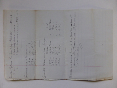 Warrnambool and District Historical Society Inc.
Document, Traffic Returns - Tramway, 1880
... Street (south of Merri St) Warrnambool great-ocean-road ...This is a traffic report of the Warrnambool Tramway in 1880. The Warrnambool Tramway ran from the south end of Fairy Street near the present day railway sheds past the site of the old Woollen Mill, then extended towards the Warrnambool Bay on the easterly side of the site today of the Lady Bay Apartments and on to the Tramway Jetty. The Tramway was completed in 1858 and was horse-drawn. It was leased to private individuals until 1864 when the Warrnambool Council took over the management. The Tramway closed in 1890 when the Breakwater was opened and it had its own spurline from the railway station to the end of the Breakwater. The 1880 report shows that contractors were paid over £300 and that 26, 409 tons of potatoes and 9167 bales of wool were carried by the Tramway in that year. This report is of interest as it shows the operations of the Warrnambool Tramway in 1880. The Tramway was significant in the maritime history of Warrnambool.This is a single foolscap-size sheet with handwritten material concerning a report of the Warrnambool Tramway operations in 1880. The writing is in black ink. The page has a large red-lined margin on the left side. The sheet is a little stained where it has been folded.history of warrnambool, warrnambool tramway -
 Warrnambool RSL Sub Branch
'A Little Parable'. A humourous piece written in the 1950s, about Bob's friend (and Madge's younger sister Betty's husband) LES ROSS, Reg. No. 2475, a veteran of the 5th Machine Gun Company, 18th Battalion, in the Middle East and on the Western Front and later, a fighter pilot with the Australian Flying Corps. He re-enlisted in WW2 and served in the RAAF, in northern Australia, in air traffic control. (Photos of Les courtesy of Les and Betty's son, Robert Hamilton Ross)
snape collection