Showing 322 items
matching water life
-
 Wodonga & District Historical Society Inc
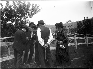
Negative - Haeusler Glass Negatives Collection -- Haeuslers inspecting fruit
The Wodonga Historical Society Haeusler Collection provides invaluable insight into life in late nineteenth and early twentieth century north east Victoria. The collection comprises manuscripts, personal artefacts used by the Haeusler family on their farm in Wodonga, and a set of glass negatives which offer a unique visual snapshot of the domestic and social lives of the Haeusler family and local Wodonga community. The Haeusler family migrated from Prussia (Germany) to South Australia in the 1840s and 1850s, before purchasing 100 acres of Crown Land made available under the Victorian Lands Act 1862 (also known as ‘Duffy’s Land Act’) in 1866 in what is now Wodonga West. The Haeusler family were one of several German families to migrate from South Australia to Wodonga in the 1860s. This digital image was produced from one of the glass negatives that form part of the collection, probably taken by Louis Haeusler (b.1887) with the photographic equipment in the Wodonga Historical Society Haeusler Collection. This item is unique and has well documented provenance and a known owner. It forms part of a significant and representative historical collection which reflects the local history of Wodonga. It contributes to our understanding of domestic and family life in early twentieth century Wodonga, as well as providing interpretative capacity for themes including local history and social history.Digital image created from the Haeusler Glass negative collection. The image shows the men inspecting the fruit for codlin moth which was new to the area. August Klinge holds a water divining rod behind his back.wodonga pioneers, haeusler family, glass negatives, dry plate photography -
 Wodonga & District Historical Society Inc
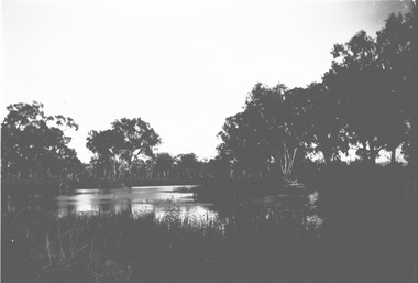
Negative - Haeusler Glass Negatives Collection - Water view near Wodonga
The Wodonga Historical Society Haeusler Collection provides invaluable insight into life in late nineteenth and early twentieth century north east Victoria. The collection comprises manuscripts, personal artefacts used by the Haeusler family on their farm in Wodonga, and a set of glass negatives which offer a unique visual snapshot of the domestic and social lives of the Haeusler family and local Wodonga community. The Haeusler family migrated from Prussia (Germany) to South Australia in the 1840s and 1850s, before purchasing 100 acres of Crown Land made available under the Victorian Lands Act 1862 (also known as ‘Duffy’s Land Act’) in 1866 in what is now Wodonga West. The Haeusler family were one of several German families to migrate from South Australia to Wodonga in the 1860s. This digital image was produced from one of the glass negatives that form part of the collection, probably taken by Louis Haeusler (b.1887) with the photographic equipment in the Wodonga Historical Society Haeusler Collection. This item is unique and has well documented provenance and a known owner. It forms part of a significant and representative historical collection which reflects the local history of Wodonga. It contributes to our understanding of domestic and family life in early twentieth century Wodonga, as well as providing interpretative capacity for themes including local history and social history.Digital image created from the Haeusler Glass negative collection. A view of water between trees near Wodonga, Victoria C. 1910wodonga pioneers, haeusler family, glass negatives, dry plate photography, wodonga -
 Wodonga & District Historical Society Inc
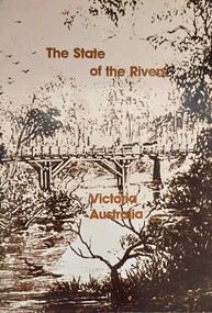
Book - The State of the Rivers, Victoria Australia, Constable, D & Smith, K, 1983
Rivers play an essential part in the life and wealth of our society. They are also the most striking feature of the landscape, contributing much to the beauty of rural and urban surroundings as well as to the recreation, peace and happiness of our people. This report includes historical colour and black and white photos and maps. It aimed to give an accurate account of the condition of the rivers of Victoria. It was produced by the Standing Consultative Committee on River Improvement.A 64 page volume including text, black and white and colour images and maps.Rivers play an essential part in the life and wealth of our society. They are also the most striking feature of the landscape, contributing much to the beauty of rural and urban surroundings as well as to the recreation, peace and happiness of our people. This report includes historical colour and black and white photos and maps. It aimed to give an accurate account of the condition of the rivers of Victoria. It was produced by the Standing Consultative Committee on River Improvement.rivers in victoria, conservation victoria, water supply victoria -
 City of Kingston
Photograph - Colour, Paul Tresize, 1998
The name Mordialloc was derived from the name Moody Yallock, which comes from the Bunurong language. The Bunurong Peoples are the Traditional Owners of this area. The name means “high water” or “high creek”. In 1839, colonial authorities declared the mouth of the creek, and an additional 830 odd acres as an Aboriginal Reserve, although this proclamation was never gazetted. The reserved land included part of the Carrum Carrum Swamp which was abundant with wild life and natural resources. Regular encroachments, including land sales which began in 1863, were made on the land until 1878 when the Reserve was declared closed, and the land was opened up to land sales. Market gardening and suburban house lots quickly began to develop, and Mordialloc became a renowned picnic and holiday site. Mordialloc Creek is a popular bay side destination for local and visitors, and is a site for boating, kayaking, fishing and swimming, along with many other activities.Colour photograph of Mordialloc Creek, looking out to the bay. Many small fishing and leisure craft are moored on either side of the banks of the creek. To the right hand side can be seen parklands, while the left hand side has a small inlet in which more small crafts are moored.mordialloc, bunurong, traditional owners, suburbs, boats, fishing, waterways -
 City of Kingston
Photograph - Colour, 1998
The name Mordialloc was derived from the name Moody Yallock, which comes from the Bunurong language. The Bunurong Peoples are the Traditional Owners of this area. The name means “high water” or “high creek”. In 1839, colonial authorities declared the mouth of the creek, and an additional 830 odd acres as an Aboriginal Reserve, although this proclamation was never gazetted. The reserved land included part of the Carrum Carrum Swamp which was abundant with wild life and natural resources. Regular encroachments, including land sales which began in 1863, were made on the land until 1878 when the Reserve was declared closed, and the land was opened up to land sales. Market gardening and suburban house lots quickly began to develop, and Mordialloc became a renowned picnic and holiday site. Mordialloc Creek is a popular bay side destination for local and visitors, and is a site for boating, kayaking, fishing and swimming, along with many other activities.Colour photograph of Mordialloc Creek, looking inland.Small fishing and leisure boats are moored on either side of creek, with a view of the Mordialloc Bridge Hotel in the background.mordialloc, bunurong, traditional owners, suburbs, boats, fishing, waterways, hotel -
 City of Kingston
Photograph - Colour, Paul Tresize, 1998
The name Mordialloc was derived from the name Moody Yallock, which comes from the Bunurong language. The Bunurong Peoples are the Traditional Owners of this area. The name means “high water” or “high creek”. In 1839, colonial authorities declared the mouth of the creek, and an additional 830 odd acres as an Aboriginal Reserve, although this proclamation was never gazetted. The reserved land included part of the Carrum Carrum Swamp which was abundant with wild life and natural resources. Regular encroachments, including land sales which began in 1863, were made on the land until 1878 when the Reserve was declared closed, and the land was opened up to land sales. Market gardening and suburban house lots quickly began to develop, and Mordialloc became a renowned picnic and holiday site. Mordialloc Creek is a popular bay side destination for local and visitors, and is a site for boating, kayaking, fishing and swimming, along with many other activities.Colour photograph of Mordialloc Creek, looking inland. Boats are moored on either side of the creek and the Bridge Hotel is visible in the background.mordialloc, bunurong, traditional owners, suburbs, boats, fishing, waterways, hotel -
 City of Kingston
Photograph - Colour, Paul Tresize, 1998
The name Mordialloc was derived from the name Moody Yallock, which comes from the Bunurong language. The Bunurong Peoples are the Traditional Owners of this area. The name means “high water” or “high creek”. In 1839, colonial authorities declared the mouth of the creek, and an additional 830 odd acres as an Aboriginal Reserve, although this proclamation was never gazetted. The reserved land included part of the Carrum Carrum Swamp which was abundant with wild life and natural resources. Regular encroachments, including land sales which began in 1863, were made on the land until 1878 when the Reserve was declared closed, and the land was opened up to land sales. Market gardening and suburban house lots quickly began to develop, and Mordialloc became a renowned picnic and holiday site. Mordialloc Creek is a popular bay side destination for local and visitors, and is a site for boating, kayaking, fishing and swimming, along with many other activities.Colour photograph of Mordialloc Creek with boats moored on both sides of the street and Pompei's boat yard visible on the right hand side of the creek., Main Street and St Brigid's Catholic Church are visible in backgroundmordialloc, bunurong, traditional owners, suburbs, boats, fishing, waterways, hotel, church -
City of Kingston
Photograph - Colour, Paul Tresize, 1998
The name Mordialloc was derived from the name Moody Yallock, which comes from the Bunurong language. The Bunurong Peoples are the Traditional Owners of this area. The name means “high water” or “high creek”. In 1839, colonial authorities declared the mouth of the creek, and an additional 830 odd acres as an Aboriginal Reserve, although this proclamation was never gazetted. The reserved land included part of the Carrum Carrum Swamp which was abundant with wild life and natural resources. Regular encroachments, including land sales which began in 1863, were made on the land until 1878 when the Reserve was declared closed, and the land was opened up to land sales. Market gardening and suburban house lots quickly began to develop, and Mordialloc became a renowned picnic and holiday site. Mordialloc Creek is a popular bay side destination for local and visitors, and is a site for boating, kayaking, fishing and swimming, along with many other activities.Colour photograph of Mordialloc Creek with boats moored on both sides of the street and Pompei's boat yard visible on the right hand side of the creek., Main Street and St Brigid's Catholic Church are visible in background.mordialloc, bunurong, traditional owners, boats, fishing -
 Melbourne Legacy
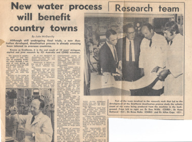
Newspaper - Document, article, New water process will benefit country towns
A newspaper article about scientists working on water treatment processes. This document was from a file of information about guest speakers (see also 00812-00822 and 00830-00837). So it is assumed that one of the scientists mentioned was approached to speak at a Legacy function. The caption mentions Dr Don Willis (CSIRO), Dr Hans Battered (ICI), Dr Brian Bolto (CSIRO), and Dr Allan Cope (ICI). Legatees met regularly and had guest speakers to entertain and inform on different subjects at their Tuesday Luncheons. The Programme Committee was responsible for organising the speakers.A record that the speakers at Legacy functions came from many walks of life and the subjects spoken on were varied.Newspaper article with black and white photos of scientists.speakers, legatee event -
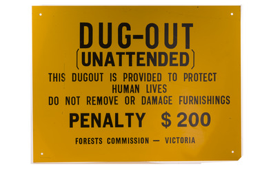 Forests Commission Retired Personnel Association (FCRPA)
Dugout sign, Post 1966
Considered in terms of both loss of property and loss of life, the Black Friday bushfires on 13 January 1939 were one of the worst disasters to have occurred in Australia and certainly the worst bushfire up to that time. The fires burnt 2 million hectares, 69 sawmills were destroyed, 71 people died, and several towns and sawmills were entirely obliterated. Among those killed were four men from the Commission The subsequent Royal Commission conducted by Judge Leonard Stretton has been described as one of the most significant inquiries in the history of Victorian public administration. Its recommendations led to sweeping changes. In addition to building dams and water points, the Stretton Royal Commission recommended expanding and controlling the use of bushfire dugouts at forest sawmills. Well-constructed dugouts had saved the lives of many sawmill workers and their families during the 1939 bushfires. But in some locations, they had proved fatal. Dugouts became mandatory for those few sawmills that remained in the forest after the 1939 fires. Many remote logging coupes and FCV roading camps also had dugouts. The local District Forester was required to make annual pre-season inspections of all dugouts on State forests and those within the Fire Protected Area (FPA). Some were built privately on private land. Most were primitive construction with a log or corrugated iron roof covered with earth. A hessian bag often hung at the entrance to keep the heat and smoke out. But they were dark and damp with snakes and other creepy crawlies often lurking inside. By 1940-41 there were 19 new dugouts constructed by the Commission and a further 128 by forest licensees. Ten years later there were 8 new Commission dugouts and 21 new ones built by other interests. By 1960-61 the rate of new builds was declining but the Commission still managed 103 dugouts while 127 were looked after by others. However, as the forest road network improved and gave all-weather access to modern two-wheel-drive vehicles the reliance on dugouts receded.Large metal sign that was positioned near forest dugoutsbushfire, forest signs, forests commission victoria (fcv) -
Port Melbourne Historical & Preservation Society
Book, Life on the bend, Jul 2017
"Life on the bend" Oblong book. Front cover photographs on blue background. Back cover blue with context logo.. Book explores 8 themes including industry, early settlement, identity ."Life on the bend" social history of Fishermans Bend Melbournebuilt environment - industrial, natural environment, fishermans bend -
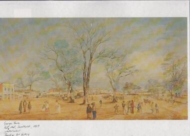 Bendigo Historical Society Inc.
Document - PUBLISHED ARTICLES: THE PAINTER GEORGE ROWE
Published articles about the painter George Rowe: a. article from un-named magazine - ''A nineteenth century romance - George Rowe and his wife Philippa Curtis’’ (2 pages); b. second part of article, continued from a. (3 pages); c. single page titled ''George Rowe's Town'' re exhibition devoted to George Rowe's life in Cheltenham, England (no date). (Transferred to Box 652 June 8) g. Laminated Print of George Rowe's watercolour painting of Pall Mall Sandhurst 1857. Original held by Bendigo Art Gallery.George Rowe, Pall Mall, Sandhurst, 1857. Water Colour. Bendigo Art Gallery.ephemera, mementoes, general interest, george rowe. cheltenham -
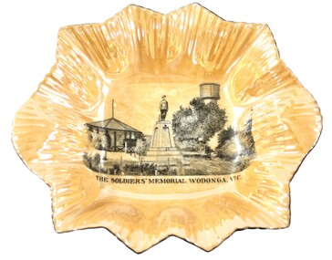 Wodonga & District Historical Society Inc
Memorabilia - Woodland Grove Souvenir dish made by RKG under licence for Royal Sydney China, Czechoslovakia, c. 1920, RKG, c. 1921 - 1938
A wide range of souvenirs have been produced to commemorate Wodonga and its landmarks over time. These items document key changes in Wodonga and its heritage. The producers mark on the plate was used by the company RKG Czechoslovakia between 1921 and 1938 This plate depicts three key landmarks in Wodonga. THE SOLDIERS' MEMORIAL in Wodonga was unveiled on Tuesday 18th November 1924. It was designed by Messrs. Hosken & Co., of Hawthorn, Victoria. The monument is all of Australian workmanship. The pedestal is made of Harcourt granite, 9ft x 9ft at the base, and rising in seven courses to a height of 10ft 2in. The emblems (rising sun and wreath) are of bronze, and the lettering of the inscription and names of fallen soldiers are in raised lead letters. Originally the Memorial was completed with a full life size, 6ft in height, sculpture of an Australian soldier in Sicilian marble. The memorial bore the inscriptions: ERECTED BY THE RESIDENTS OF WODONGA AND DISTRICT IN MEMORY of the Men of this Town and District who fell in the Great War, 1914-1919, Also in grateful recognition of the men who served and returned. “Lest We Forget.” In 1982, due to frequent vandalism and high cost of materials to repair, the soldier statue was removed and later installed at the RSL Rooms. THE WATER TOWER is a major landmark of High Street, Wodonga. It began operation from 1924 until it ceased operation in 1959. It stood unused for a decade until the lower section was modified and put to use as “ The Tower’s Cobbler’s Inn” in 1962. In 1972 Wodonga City Council proposed to demolish the Tower. Their suggestion received an unfavorable response from the city’s citizens, so the Tower still stands today. THE BAND ROTUNDA was officially opened on Sunday 5th September 1920 at the naming of the triangular reserve at the corner of High and Hovell Streets as Woodland Grove. The Wodonga Band gave a public performance on this occasion. The tri-coloured ribbon, which stretched across the entrance to the Rotunda was cut by Mrs R.H Murphy, daughter of Mr. John Woodland, secretary of the Wodonga Shire Council for 35 years, after whom the area was named. The rotunda has since been moved to Martin Park, Wodonga. Small china pieces carrying scenic views of holiday destinations were a popular kind of souvenir during much of the 20th century. These items have local and social significance as they reflect the landmarks or local features valued by the community over time. An apricot irregular shaped dish made from lustre ware with a drawing of the Wodonga Soldiers Memorial, Water Tower and Rotunda. The manufacturer's mark is imprinted on the base. Text under the image says 'THE SOLDIERS' MEMORIAL. WODONGA. VICManufacturer's trademark printed on base, in orange paint, in a circular formation 'ROYAL SYDNEY CHINA / MADE IN / CZECHOSLOVAKIA', within circular formation '(crown) / RK / G' ('RK / G' within circle with handles).porcelain, wodonga, royal sydney china, soldier memorial, wodonga souvenirs -
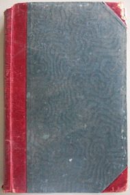
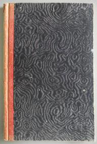 Warrnambool and District Historical Society Inc.
Journal - Diary, Diary of Augustus Bostock 1904-1907, Circa 1904
Augustus Bostock was the 9th child of Robert & Rachael Bostock of Vaucluse Epping Forest, Van Diemen’s Land. He was only 4 years old when his mother died. He was inspired by his father to seek his fortune in the Western District of Victoria. He arrived around 1850. He married Margaret Aitkin in July 1865. Augustus owned several properties in the district and leased others. He sat on the court of Warrnambool, Mortlake or Hexham as required. He resided at Marramook in Hawkesdale and later moved to Vaucluse in Hopetoun Road Warrnambool, where he died in 1920 at the age of 87. He was involved in many aspects of life in the Western District, racing, cricket, and social activities to name a few. This diary shows the daily entries over a long period of time with activities ranging from fencing, visiting neighbours and weather details. It mentions many local people and many properties he visited. Augustus Bostock along with a number of his brothers was one of the earliest pioneers in the Western District of Victoria. This diary sheds considerable light onto the life of Augustus and people of his era. There is a wealth of information on a range of topics relating to early life in Warrnambool and district.Cardboard cover, water- waved patterned in black and grey with orange cloth binding. Pages are all handwritten with dates in margin. Augustus Bostock Diary for 1904.diary of augustus bostock 1904-1907, warrnambool -
 Eltham District Historical Society Inc
Photograph - Digital Photograph, Alan King, Pigeon Bank, Kangaroo Ground-Warrandyte Road, Kangaroo Ground, 6 February 2008
In 1848, Francis Rogerson form Dumfriesshire, Scotland purchased 80 acres of land at Kangaroo Ground on which he built a two-roomed bark hut. He named the property afterr the many Bronzewings and Wonga Pigeons in the area. Ewen Hugh Cameron moved to Pigeon Bank the same year he was elected to Parliament as the Member for Evelyn. At the time he moved in, Pigeon Bank had six rooms and the present water well. He made further extensive additions and lived there until his death in 1915. Covered under Heritage Overlay, Nillumbik Planning Scheme. Published: Nillumbik Now and Then / Marguerite Marshall 2008; photographs Alan King with Marguerite Marshall.; p27 Pigeon Bank, on the Kangaroo Ground – Warrandyte Road, Kangaroo Ground, is one of the Shire’s oldest farm dwellings, and has been home to some of the district’s earliest and most distinguished families. Although close to the road, the white weatherboard Victorian farmhouse is ensured privacy by the trees and hedges around it. On 4.8 hectares of farmland, Pigeon Bank is surrounded by rolling hills, farmland and bush, the peace of which is punctuated by an occasional birdcall. Pigeon Bank’s first owner was Francis Rogerson, from Dumfriesshire, Scotland, who bought 80 acres (32.4ha) of land in 1848 on which he built a two-roomed bark hut. Today this is the centre piece of the 14-room home.1 Rogerson lined the rooms with tongue-and-groove boards and roofed them with wooden shingles and sapling frames, which remain under the present green corrugated iron roof. He named Pigeon Bank after the many forest bronzewing and Wonga Pigeons in the area at the time, and the name Bank was commonly used in Scotland. Rogerson was united with one of the oldest families in the area when his sister Janet married John Bell, son of William, the original Bell settler. When Ewen Cameron moved to Pigeon Bank in 1874 it had six rooms and the present water well. He made extensive additions to the house and farm buildings and lived at Pigeon Bank until his death in 1915. Cameron, who had arrived in Melbourne from Scotland in 1853, contributed an enormous amount to the community. He worked as a builder, as a miner at Andersons Creek, a storekeeper at Queenstown2 and as the first postmaster at Warrandyte. In 1867 he married Agnes Bell, daughter of local farmer, John Bell. Cameron was a member of the Eltham Road Board (which preceded the Shire Council) and for more than 50 years, from 1863, he was an Eltham Shire Councillor, being President three times. Cameron was the Member for Evelyn for 40 years from 1874. In the 1880s he became the Government Whip, in 1902 the Minister for Mines and Water Supply, and in 1904, the Minister for Health, Cameron was also an outstanding farmer, whose farm won the Agricultural Department prize for the finest in the district, three consecutive times. Not surprisingly Pigeon Bank became the centre of district life. Every New Year’s Eve, Cameron hired a highland piper, who marched from the Kangaroo Ground school house to Pigeon Bank playing his pipes.3 Distinguished visitors included opera singer, Dame Nellie Melba, Victorian Premier, Thomas Bent, Governor, Lord Hopetoun and artist, Longstaff. Following Cameron’s death, the property changed hands several times, then returned to the family in 1919 when bought by Gordon Cameron. As the car took over from the horse, Pigeon Bank entered difficult times because the farm had produced chaff and oats and bred Clydesdales and harness ponies. In 1926 Mr Matthews bought the property and made many alterations including pulling down the kitchen, which had been separate from the main house. The property again changed hands several times. One owner was Senator James F Guthrie, who added a sunroom. In 1968 the house again returned to the Cameron family, when Vera Jackson, a grand-daughter of Ewen Cameron, and her husband, bought the property. The Bishop family, who were sixth and seventh generation Bells and also descended from the Camerons, restored the house in the 1980s. Today tongue-and-groove boards still line part of the hall (which retains two fine arches), the breakfast room, and Ewen Cameron’s former room. Five original fireplaces in the bed and living rooms are still in working order. The wide veranda with a curved iron roof and ornate iron lace work bounds three sides of the house, and nearby a windmill stands beside the water well. Sue and Ron James, who bought the property in 2001, made extensive improvements to the homestead and meticulously restored the grounds to their original state.This collection of almost 130 photos about places and people within the Shire of Nillumbik, an urban and rural municipality in Melbourne's north, contributes to an understanding of the history of the Shire. Published in 2008 immediately prior to the Black Saturday bushfires of February 7, 2009, it documents sites that were impacted, and in some cases destroyed by the fires. It includes photographs taken especially for the publication, creating a unique time capsule representing the Shire in the early 21st century. It remains the most recent comprehenesive publication devoted to the Shire's history connecting local residents to the past. nillumbik now and then (marshall-king) collection, ewen hugh cameron, francis rogerson, kangaroo ground, kangaroo ground-warrandyte road, pigeon bank -
 Eltham District Historical Society Inc
Photograph - Digital Photograph, Alan King, Cameron family graves, Kangaroo Ground Cemetery, Eltham-Yarra Glen Road, Kangaroo Ground, 28 January 2008
Six year old Judith Furphy was the first person known to have been buried at Kangaroo Ground Cemetery in May 1851. The cemetery is situated on an ancient river bed with exposed Nillumbik sands. The rest of the district is formed from black volcanic soil which was hard to dig. According to local historian Mick Woiwod (deceased) the site may have been a burial ground for the local Wurundjeri people as the exposed softer sands were always their prefered camping sites. The Hon. Ewen Hugh Cameron who lived at Pigeon Bank and was the Member for Evelyn for 40 years (1874-1914) was buried here in 1915. Published: Nillumbik Now and Then / Marguerite Marshall 2008; photographs Alan King with Marguerite Marshall.; p39 The Wurundjeri people might have buried their dead on the site of the Kangaroo Ground Cemetery, according to local historian Mick Woiwod. Kangaroo Ground was a premier hunting ground, but camping on the black volcanic soil would have been uncomfortable. Unlike most of Kangaroo Ground, its cemetery, on an ancient river bed, comprises a rare exposure of Nillumbik sands – always the preferred campsite for Aboriginal people. The cemetery area is the only place where the soil was soft enough to dig a grave easily.1 Six-year-old Judith Furphy was the first person known to have been laid to rest at the Kangaroo Ground Cemetery. She died on May 17, 1851, from a chill caught by resting on wet grass. Local Andrew Ross wrote ‘..no public burying place existed nearer than Melbourne. The case being considered urgent, a general meeting of the settlers took place on the evening of the 17th……. The result was the selection of unoccupied crown land …….which was subsequently granted by Government for a public cemetery.’2 Judith was buried the next day on May 18. Her grave was marked by the trustees with a plaque, which unfortunately states nine years old, when she was probably only six. Judith came from an illustrious family. Her brother, Joseph, was the author of Such is Life and other works. Another brother, John, developed and manufactured the famous Furphy water cart, which distributed water to World War One soldiers along with the latest rumours. Hence the name Furphy entered the Australian idiom, as synonymous with ‘rumour’. Judith’s father Samuel helped build the first Kangaroo Ground church school. Inside, near the entrance of the cemetery, on Yarra Glen Road, stand a rotunda and a water tank. Occasional benches invite mourners to pause and remember. The gate with wrought iron and brick supports, bears the inscription ‘Erected by Sir Ewen and Lady Cameron in memory of their daughter, Flora Margaret’. These are only two of the famous people connected with this cemetery. The Hon. Ewen Hugh Cameron JP and MLA from 1874 to1914, who lived at Pigeon Bank, Warrandyte Road, was buried here in 1915. Unrelated, but with the same name, was Sir Ewen Cameron who had been Minister for Health and was laid to rest there in 1964. Sir Herbert Gepp, a leading industrialist and the former owner of Garden Hill, at Yarra Glen Road, was buried there in 1954.3 Many of the more imposing tombstones belong to the earlier graves. Unfortunately bushfires have cracked several. But this adds to the melancholy attractiveness of the cemetery, graced by some beautiful eucalypts, cypress and pines. Early pioneering families represented at the cemetery include Armstrong, Barr, Bell, Harkness, Jardine, Johnston, Rogerson, Stevenson, Thomson and Walters. Armstrong and Bell were among the first families to come to the district and Stevenson owned the district’s first sheep station. It took in much of present day Christmas Hills, which was the name he gave his sheep station. Harkness was the first to suggest a Kangaroo Ground school be built, and one of the first to suggest establishing the Eltham District Road Board. Many of these families leased pastoral land before the mid-century and bought land when it came on sale in 1849. In the cemetery’s early days sections were devoted to the major Christian denominations (mainly the Protestant) and one section was set aside for ‘other’ or ‘non-believers’. However in modern times burial plots have not been placed in areas according to religious beliefs.This collection of almost 130 photos about places and people within the Shire of Nillumbik, an urban and rural municipality in Melbourne's north, contributes to an understanding of the history of the Shire. Published in 2008 immediately prior to the Black Saturday bushfires of February 7, 2009, it documents sites that were impacted, and in some cases destroyed by the fires. It includes photographs taken especially for the publication, creating a unique time capsule representing the Shire in the early 21st century. It remains the most recent comprehenesive publication devoted to the Shire's history connecting local residents to the past. nillumbik now and then (marshall-king) collection, kangaroo ground, eltham-yarra glen road, agnes bell cameron, agnes cameron (nee bell), cameron family, edward aubrey haughton, eugene cameron, evelyn florence cameron, ewen hugh cameron, gravestones, jane armstrong, jane bell, jessie agnes haughton (nee cameron), jessie cameron, john donald cameron, kangaroo ground cemetery, neville cameron, simon armstrong, vera cameron, william bell armstrong, wurundjeri -
 Emerald Museum & Nobelius Heritage Park
Book, Alfred and Ursula Klink, E.E. Kurth and his work, Reflections on a Creative Life by Alfred and Ursula Kling, 2014
Professor Ernest Edgar Kurth of the University of Tasmania, invented a faster, simpler and cleaner way to produce charcoal on a continuous basis during the second world war. The charcoal was used to produce a combustible gas in motor cars, as a substitute for petrol, which was heavily rationed. The first batch of charcoal was produced in February 1942 and continued until the end of the war. Wood from stringybark trees was cut into lengths and fed into a kiln which converted it into charcoal. The Kiln is located on Beenak Road, 7km north of Gembrook. It has great historical significance, particularly as an alternative supplier of fuel during the second world war. It is a State Registered facility, managed by the Friends of Kirth Kiln and the park is managed by Parks Victoria Green soft covered book of 150 pages, with a photo of 2 men and a boy out in the bush with 3 fires burning.Contains a Prelude about Ernest Edgar Kurth written by Alfred Klink (2013) and a Foreward by John Sullivan (Heritage Officer of Parks Victoria). There is an Acknowledgement page, with recognition given to the grant provided by the Department of Sustainability, Environment, Water, Population and Communities. e.e. kurth, kirth kiln, charcoal kiln, parks victoria -
 Linton and District Historical Society Inc
Photograph, Dam Builders, Battery Dam, Linton, 1910
Mounted black and white image. William (or Richard?) Ching and team with horses and drays, creating water dam at Linton, 1910battery dam, dam building, dam workers, dams, horses, working life -
 Wodonga & District Historical Society Inc
Souvenir - Souvenir Cream Jug - Soldiers' Memorial, Wodonga
This item is from a collection donated by descendants of John Francis Turner of Wodonga. A wide range of small china pieces carrying scenic views of holiday destinations or key locations were a popular kind of souvenir during much of the 20th century. Several different items have been produced to commemorate Wodonga and its landmarks over time. These items document key changes in Wodonga and its heritage. This plate depicts three key landmarks in Wodonga. THE SOLDIERS' MEMORIAL in Wodonga was unveiled on Tuesday 18th November 1924. It was designed by Messrs. Hosken & Co., of Hawthorn, Victoria. The monument is all of Australian workmanship. The pedestal is made of Harcourt granite, 9ft x 9ft at the base, and rising in seven courses to a height of 10ft 2in. The emblems (rising sun and wreath) are of bronze, and the lettering of the inscription and names of fallen soldiers are in raised lead letters. Originally the Memorial was completed with a full life size, 6ft in height, sculpture of an Australian soldier in Sicilian marble. The memorial bore the inscriptions: ERECTED BY THE RESIDENTS OF WODONGA AND DISTRICT IN MEMORY of the Men of this Town and District who fell in the Great War, 1914-1919, Also in grateful recognition of the men who served and returned. “Lest We Forget.” In 1982, due to frequent vandalism and high cost of materials to repair, the soldier statue was removed and later installed at the RSL Rooms. THE WATER TOWER is a major landmark of High Street, Wodonga. It began operation from January 1924 until it ceased operation in 1959. It stood unused for a decade until the lower section was modified and put to use as “ The Tower’s Cobbler’s Inn” in 1962. In 1972 Wodonga City Council proposed to demolish the Tower. Their suggestion received an unfavorable response from the city’s citizens, so the Tower still stands today. THE BAND ROTUNDA was officially opened on Sunday 5th September 1920 at the naming of the triangular reserve at the corner of High and Hovell Streets as Woodland Grove. The Wodonga Band gave a public performance on this occasion. The tri-coloured ribbon, which stretched across the entrance to the Rotunda was cut by Mrs R.H Murphy, daughter of Mr. John Woodland, secretary of the Wodonga Shire Council for 35 years, after whom the area was named. The rotunda has since been moved to Martin Park, Wodonga.This item comes from a collection used by a prominent citizen of Wodonga. It is also an excellent example of souvenir items created featuring landmarks to represent the city of Wodonga.White glazed porcelain cream jug with grooved square handle. The base is unglazed. The rim and outer face of the handle are outlined in black paint. On one side of the jug is a black transfer print of a the Wodonga Soldiers' Memorial. Text underneath the scene reads "THE SOLDIERS' MEMORIAL, WODONGA, VIC."'. The manufacturer's trademark is printed on the base of the jug. RKG stood for Rudolf Kampf of Grunlas. The mark with the initials under the crown was used from 1921 to 1938.Beneath the image: 'THE SOLDIERS' MEMORIAL WODONGA VIC" Under the jug Manufacturer's trademark printed in orange paint, in a circular formation '(crown) / RK / G' ('RK / G' within circle with handles) above the words "Made in Czechoslovakia"domestic items, souvenir wodonga, woodland grove wodonga -
 Wodonga & District Historical Society Inc
Souvenir - China Souvenir Plate Soldiers' Memorial. Wodonga, Victoria China, c1924 - 1939
This item is from a collection donated by descendants of John Francis Turner of Wodonga. A wide range of small china pieces carrying scenic views of holiday destinations or key locations were a popular kind of souvenir during much of the 20th century. Several different items have been produced to commemorate Wodonga and its landmarks over time. These items document key changes in Wodonga and its heritage. This plate depicts three key landmarks in Wodonga. THE SOLDIERS' MEMORIAL in Wodonga was unveiled on Tuesday 18th November 1924. It was designed by Messrs. Hosken & Co., of Hawthorn, Victoria. The monument is all of Australian workmanship. The pedestal is made of Harcourt granite, 9ft x 9ft at the base, and rising in seven courses to a height of 10ft 2in. The emblems (rising sun and wreath) are of bronze, and the lettering of the inscription and names of fallen soldiers are in raised lead letters. Originally the Memorial was completed with a full life size, 6ft in height, sculpture of an Australian soldier in Sicilian marble. The memorial bore the inscriptions: ERECTED BY THE RESIDENTS OF WODONGA AND DISTRICT IN MEMORY of the Men of this Town and District who fell in the Great War, 1914-1919, Also in grateful recognition of the men who served and returned. “Lest We Forget.” In 1982, due to frequent vandalism and high cost of materials to repair, the soldier statue was removed and later installed at the RSL Rooms. THE WATER TOWER is a major landmark of High Street, Wodonga. It began operation from January 1924 until it ceased operation in 1959. It stood unused for a decade until the lower section was modified and put to use as “ The Tower’s Cobbler’s Inn” in 1962. In 1972 Wodonga City Council proposed to demolish the Tower. Their suggestion received an unfavorable response from the city’s citizens, so the Tower still stands today. THE BAND ROTUNDA was officially opened on Sunday 5th September 1920 at the naming of the triangular reserve at the corner of High and Hovell Streets as Woodland Grove. The Wodonga Band gave a public performance on this occasion. The tri-coloured ribbon, which stretched across the entrance to the Rotunda was cut by Mrs R.H Murphy, daughter of Mr. John Woodland, secretary of the Wodonga Shire Council for 35 years, after whom the area was named. The rotunda has since been moved to Martin Park, Wodonga.This item comes from a collection used by a prominent citizen of Wodonga. It is also an excellent example of souvenir items created featuring landmarks to represent the city of Wodonga.A china plate depicting the Soldiers' Memorial Wodonga. The central coloured image is surrounded by a 8 representations of a variety of flowers and a silver edge trim. The makers mark underneath the dish was used between 1918 - 1939 so assists in establishing provenance of the irem.Beneath image: "SOLDIERS' MEMORIAL WODONGA On back of dish, Beneath a crown " VICTORIA CHINA CZECHOSLAVAKIA"victoria china, souvenir wodonga, wodonga soldiers memorial, woodland grove wodonga -
 Wodonga & District Historical Society Inc
Memorabilia - China Souvenir Cup Woodland Grove Wodonga, c. 1925 - 1940
A wide range of small china pieces carrying scenic views of holiday destinations or key locations were a popular kind of souvenir during much of the 20th century. Several different items have been produced to commemorate Wodonga and its landmarks over time. These items document key changes in Wodonga and its heritage. This cup depicts three key landmarks in Wodonga. THE SOLDIERS' MEMORIAL in Wodonga was unveiled on Tuesday 18th November 1924. It was designed by Messrs. Hosken & Co., of Hawthorn, Victoria. The monument is all of Australian workmanship. The pedestal is made of Harcourt granite, 9ft x 9ft at the base, and rising in seven courses to a height of 10ft 2in. The emblems (rising sun and wreath) are of bronze, and the lettering of the inscription and names of fallen soldiers are in raised lead letters. Originally the Memorial was completed with a full life size, 6ft in height, sculpture of an Australian soldier in Sicilian marble. The memorial bore the inscriptions: ERECTED BY THE RESIDENTS OF WODONGA AND DISTRICT IN MEMORY of the Men of this Town and District who fell in the Great War, 1914-1919, Also in grateful recognition of the men who served and returned. “Lest We Forget.” In 1982, due to frequent vandalism and high cost of materials to repair, the soldier statue was removed and later installed at the RSL Rooms. THE WATER TOWER is a major landmark of High Street, Wodonga. It began operation from 1924 until it ceased operation in 1959. It stood unused for a decade until the lower section was modified and put to use as “ The Tower’s Cobbler’s Inn” in 1962. In 1972 Wodonga City Council proposed to demolish the Tower. Their suggestion received an unfavorable response from the city’s citizens, so the Tower still stands today. THE BAND ROTUNDA was officially opened on Sunday 5th September 1920 at the naming of the triangular reserve at the corner of High and Hovell Streets as Woodland Grove. The Wodonga Band gave a public performance on this occasion. The tri-coloured ribbon, which stretched across the entrance to the Rotunda was cut by Mrs R.H Murphy, daughter of Mr. John Woodland, secretary of the Wodonga Shire Council for 35 years, after whom the area was named. The rotunda has since been moved to Martin Park, Wodonga. This item has local historic and social significance as it depicts which features of the city the community valued in the past. It has artistic significance as an example of the kinds of souvenirs used widely across Australia to represent communities and the landscape.A white souvenir cup made from china with a water colour image of Woodland Grove, Wodonga which incorporates the Soldier Memorial, Water Tower and the Rotunda."WOODLAND GROVE, WODONGA."souvenirs, wodonga, woodland grove, soldiers memorial, wodonga landmarks -
 Wodonga & District Historical Society Inc
Memorabilia - China Souvenir Bowl Woodland Grove Wodonga, c. 1920 - 1940
A wide range of small china pieces carrying scenic views of holiday destinations or key locations were a popular kind of souvenir during much of the 20th century. Several different items have been produced to commemorate Wodonga and its landmarks over time. These items document key changes in Wodonga and its heritage. This plate depicts three key landmarks in Wodonga. THE SOLDIERS' MEMORIAL in Wodonga was unveiled on Tuesday 18th November 1924. It was designed by Messrs. Hosken & Co., of Hawthorn, Victoria. The monument is all of Australian workmanship. The pedestal is made of Harcourt granite, 9ft x 9ft at the base, and rising in seven courses to a height of 10ft 2in. The emblems (rising sun and wreath) are of bronze, and the lettering of the inscription and names of fallen soldiers are in raised lead letters. Originally the Memorial was completed with a full life size, 6ft in height, sculpture of an Australian soldier in Sicilian marble. The memorial bore the inscriptions: ERECTED BY THE RESIDENTS OF WODONGA AND DISTRICT IN MEMORY of the Men of this Town and District who fell in the Great War, 1914-1919, Also in grateful recognition of the men who served and returned. “Lest We Forget.” In 1982, due to frequent vandalism and high cost of materials to repair, the soldier statue was removed and later installed at the RSL Rooms. THE WATER TOWER is a major landmark of High Street, Wodonga. It began operation from 1924 until it ceased operation in 1959. It stood unused for a decade until the lower section was modified and put to use as “ The Tower’s Cobbler’s Inn” in 1962. In 1972 Wodonga City Council proposed to demolish the Tower. Their suggestion received an unfavorable response from the city’s citizens, so the Tower still stands today. THE BAND ROTUNDA was officially opened on Sunday 5th September 1920 at the naming of the triangular reserve at the corner of High and Hovell Streets as Woodland Grove. The Wodonga Band gave a public performance on this occasion. The tri-coloured ribbon, which stretched across the entrance to the Rotunda was cut by Mrs R.H Murphy, daughter of Mr. John Woodland, secretary of the Wodonga Shire Council for 35 years, after whom the area was named. The rotunda has since been moved to Martin Park, Wodonga. This item has local historic and social significance as it depicts which features of the city the community valued in the past. It has artistic significance as an example of the kinds of souvenirs used widely across Australia to represent communities and the landscape.A white glazed china souvenir bowl. Frilled edge. Includes a painted representation of Woodland Grove, Wodonga, VictoriaBeneath the painted central image "WOODLAND GROVE, WODONGAwodonga, souvenirs, woodland grove, ceramics -
 Bendigo Historical Society Inc.
Newspaper - LONG GULLY HISTORY GROUP COLLECTION: WATER IN THE VICTORIA QUARTZ
BHS CollectionPhotocopy of a newspaper article titled Water Continues to Rise in the Victoria Quartz by James Lerk. Article mentions the water problem in the Victoria Quartz Mine and where they believed it was coming from. Also mentioned is the mining inspector William Abraham. There is a short history of his working life up to the time of his qualifying as a mine manager after studying part-time for ten years at the Bendigo School of Mines. There is a dark photo of William and his horse.bendigo, history, long gully history group, the long gully history group - water in the victoria quartz, james lerk, victoria quartz, william abraham, new chum reef, matthew stevens, south bellevue, new chum and victoria mine, lazarus, new chum drainage association, william abraham snr, druid, mary kane, lady miltoa, ballarat freehold company, the wallaby, richard grenfell, bendigo advertiser, bendigo school of mines, confidence extended mine, george ellis -
 Wodonga & District Historical Society Inc
Souvenir - Souvenir Cup and Saucer Woodland Grove, Wodonga, Victoria, Royal Stafford China, c1940s
This item is from a collection donated by descendants of John Francis Turner of Wodonga. Mr. Turner was born on 6 June 1885. He completed all of his schooling at Scotts Boarding School in Albury, New South Wales. On leaving school, he was employed at Dalgety’s, Albury as an auctioneer. In 1924 John was promoted to Manager of the Wodonga Branch of Dalgety’s. On 15/03/1900 he married Beatrice Neal (born 7/12/1887 and died 7/2/1953) from Collingwood, Victoria. They had 4 daughters – Francis (Nancy), Heather, Jessie and Mary. In 1920, the family moved From Albury to Wodonga, purchasing their family home “Locherbie” at 169 High Street, Wodonga. "Locherbie" still stands in Wodonga in 2022. The collection contains items used by the Turner family during their life in Wodonga. A wide range of small china pieces carrying scenic views of holiday destinations or key locations were a popular kind of souvenir during much of the 20th century. Several different items have been produced to commemorate Wodonga and its landmarks over time. These items document key changes in Wodonga and its heritage. This plate depicts three key landmarks in Wodonga. THE SOLDIERS' MEMORIAL in Wodonga was unveiled on Tuesday 18th November 1924. It was designed by Messrs. Hosken & Co., of Hawthorn, Victoria. The monument is all of Australian workmanship. The pedestal is made of Harcourt granite, 9ft x 9ft at the base, and rising in seven courses to a height of 10ft 2in. The emblems (rising sun and wreath) are of bronze, and the lettering of the inscription and names of fallen soldiers are in raised lead letters. Originally the Memorial was completed with a full life size, 6ft in height, sculpture of an Australian soldier in Sicilian marble. The memorial bore the inscriptions: ERECTED BY THE RESIDENTS OF WODONGA AND DISTRICT IN MEMORY of the Men of this Town and District who fell in the Great War, 1914-1919, Also in grateful recognition of the men who served and returned. “Lest We Forget.” In 1982, due to frequent vandalism and high cost of materials to repair, the soldier statue was removed and later installed at the RSL Rooms. THE WATER TOWER is a major landmark of High Street, Wodonga. It began operation from January 1924 until it ceased operation in 1959. It stood unused for a decade until the lower section was modified and put to use as “ The Tower’s Cobbler’s Inn” in 1962. In 1972 Wodonga City Council proposed to demolish the Tower. Their suggestion received an unfavorable response from the city’s citizens, so the Tower still stands today. THE BAND ROTUNDA was officially opened on Sunday 5th September 1920 at the naming of the triangular reserve at the corner of High and Hovell Streets as Woodland Grove. The Wodonga Band gave a public performance on this occasion. The tri-coloured ribbon, which stretched across the entrance to the Rotunda was cut by Mrs R.H Murphy, daughter of Mr. John Woodland, secretary of the Wodonga Shire Council for 35 years, after whom the area was named. The rotunda has since been moved to Martin Park, Wodonga. This item comes from a collection used by a prominent citizen of Wodonga. It is also representative of a domestic item common in the 1940s and features significant landmarks used in many forms to represent the city of Wodonga.This bone china cup and saucer set features an image of Woodland Grove. Wodonga, Victoria. The image incorporates landmarks in Woodland Grove, including the Soldiers' Memorial, the Rotunda and the Water Tower. There is a makers' mark imprinted on the underside of the plate."ROYAL STAFFORD/BONE CHINA/ MADE IN ENGLAND/ 423" . A crown is in the centre of the textmemorabilia, woodland grove, wodonga victoria -
 Wodonga & District Historical Society Inc
Memorabilia - Souvenir Plate Woodland Grove, Wodonga, Victoria, Royal Stafford China
A wide range of small china pieces carrying scenic views of holiday destinations or key locations were a popular kind of souvenir during much of the 20th century. Several different items have been produced to commemorate Wodonga and its landmarks over time. These items document key changes in Wodonga and its heritage. This plate depicts three key landmarks in Wodonga. THE SOLDIERS' MEMORIAL in Wodonga was unveiled on Tuesday 18th November 1924. It was designed by Messrs. Hosken & Co., of Hawthorn, Victoria. The monument is all of Australian workmanship. The pedestal is made of Harcourt granite, 9ft x 9ft at the base, and rising in seven courses to a height of 10ft 2in. The emblems (rising sun and wreath) are of bronze, and the lettering of the inscription and names of fallen soldiers are in raised lead letters. Originally the Memorial was completed with a full life size, 6ft in height, sculpture of an Australian soldier in Sicilian marble. The memorial bore the inscriptions: ERECTED BY THE RESIDENTS OF WODONGA AND DISTRICT IN MEMORY of the Men of this Town and District who fell in the Great War, 1914-1919, Also in grateful recognition of the men who served and returned. “Lest We Forget.” In 1982, due to frequent vandalism and high cost of materials to repair, the soldier statue was removed and later installed at the RSL Rooms. THE WATER TOWER is a major landmark of High Street, Wodonga. It began operation from 1924 until it ceased operation in 1959. It stood unused for a decade until the lower section was modified and put to use as “ The Tower’s Cobbler’s Inn” in 1962. In 1972 Wodonga City Council proposed to demolish the Tower. Their suggestion received an unfavorable response from the city’s citizens, so the Tower still stands today. THE BAND ROTUNDA was officially opened on Sunday 5th September 1920 at the naming of the triangular reserve at the corner of High and Hovell Streets as Woodland Grove. The Wodonga Band gave a public performance on this occasion. The tri-coloured ribbon, which stretched across the entrance to the Rotunda was cut by Mrs R.H Murphy, daughter of Mr. John Woodland, secretary of the Wodonga Shire Council for 35 years, after whom the area was named. The rotunda has since been moved to Martin Park, Wodonga. This bone china plate features an image of Woodland Grove. Wodonga, Victoria. The image incorporates landmarks in Woodland Grove, including the Soldiers' Memorial, the Rotunda and the Water Tower. There is a makers' mark imprinted on the underside of the plate."ROYAL STAFFORD/BONE CHINA/ MADE IN ENGLAND/ 423" . A crown is in the centre of the textmemorabilia, woodland grove, wodonga victoria -
 Wangaratta RSL Sub Branch
Work on paper - Envelope Art
Sent to Mrs McDonald "Monald" 32 Grey Street Wangaratta from soldier during second world warVictoria's 2/24th Infantry Battalion was raised in Wangaratta in July 1940. They were welcomed with open arms by the local community as they rapidly built up their numbers. The people of Wangaratta adopted the Battalion and they became known as "Wangaratta's Own" because of the time the battalion spent in the town during its formative period prior to deployment overseas. Many of the soldiers maintained life long friendships with the people of Wangaratta. Even though the Battation was disbanded in 1946 members and their families return each year, in November, for a commemorative service at the 2/24th Battalion Memorial Wall at the Wangaratta Cemetery.Cream paper envelope with coloured drawing of small boat and three huts on stilts in water with palm trees and two mountains in background.Top left - AIR MAIL Top right - postage stamp Right side Mrs M acDonald "Monald" 32 Grey Street Wangaratta Victoria Australiaww2, envelope art -
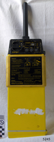 Flagstaff Hill Maritime Museum and Village
Equipment - EPIRB Transmitter
This distress EPIRB unit (Emergency Position Indication Radio Beacon) was found on the beach at Levy's Point, Warrnambool, in December 2000 by a Warrnambool resident. Local police were alerted at the time. This distress signal unit is a world-wide COSPAS/SARSAT, satellite assisted, SAR (Search and Rescue) system for location of distress transmissions emitted by an EPIRB. Offshore cruising vessels must have such a unit as part of its essential safety equipment. This model EPIRB relies on four satellites with orbit times of approximately 100 minutes. Earlier units relied solely on aircraft flying overhead to detect and forward on the EPIRB’s location to Search And Rescue authorities, whereas this new system utilises satellites. An employee from the Lokata firm provided additional information about the Lokata EPIRB units. They had a machined aluminium case with labels that were also made on site. The units could be activated manually or automatically released when a magnetic switch in the case casing was activated. This later model, circa 1983, would have been mounted externally on a vessel's bulkhead in a spring-loaded, stainless-steel protective 'skeleton' mounting, The unit released when the water pressure sensor detected a set time it was under the water, in a similar way that life crafts were released. Each unit was registered to a particular vessel - the vessel's details on this unit are indecipherable. The Lokata Company was established in 1970, designing and manufacturing marine products including communications. The company no longer makes products with the “Lokata” brand. In 2001 Sartech Engineering Ltd. took over the support for the Lokata EPIRB beacons. This emergency location device is a late 20th century invention to help save lives at sea. It adds to the history of maritime life, its risks, the lives lost as sea, and the many inventions aimed as rescuing and saving lives. The local area is notorious for the number of lives lost through shipwreck. It also carries stories of heroic efforts to save lives, and other inventions to help reduce the chance of accidents at sea.EPIRB unit; “Emergency Position Indication Radio Beacon”. A distress communication unit for sending a distress location transmission in an emergency at sea. The EPIRB is a yellow, rectangular box with dials, buttons, indicator lights and instruction. An antenna protrudes from the top of the unit. The EPIRB unit sends a 406P (X) EPIRB, with 406M-Hz frequency, 48-hour duration signal. The maker was LOKATA Ltd in England. Remnants of a white label remain on the side. Circa 1980s."NAME OF VESSEL 'SERVICE IF SELF TEST FAILS' " “LO-KATA” moulded into the body. "406P (X) EPIRB" “Model 406” "Lokata Type No 92408" "UK Type approved to MPT 1278" "Class 2" "Made by Lokata Ltd, Falmouth Cornwall England TR10 8AE"" "LOKATE LTD. New North Road Hainault, Ilford Essex IG6 2UR" "ARMED / SAFE / TRANSMIT / CODE / DISPLAY / SET / wait / pass / fail / TEST" "IDENTIFIER / 1349:24034234N" [some characters may be different] "COUNTRY / DENMARK" "VESSEL IDENTITY / 124 [the rest is indecipherable]flagstaff hill, warrnambool, shipwrecked-coast, flagstaff-hill, flagstaff-hill-maritime-museum, maritime-museum, shipwreck-coast, flagstaff-hill-maritime-village, emergency position indicating radio beacon, epirb, lokata ltd, marine safety equipment, satellite transmitting beacon, safety equipment, distress signal, life saving, safety at sea, shipwreck location, lo-kata, falmouth, emergency, beacon, radio signal, communication, marine equipment -
 Warrnambool and District Historical Society Inc.
Journal - Diary, Diary of Augustus Bostock 1890, Circa 1890
Augustus Bostock was the 9th child of Robert & Rachael Bostock of Vaucluse Epping Forest, Van Diemen’s Land. He was only 4 years old when his mother died. He was inspired by his father to seek his fortune in the Western District of Victoria. He arrived around 1850. He married Margaret Aitkin in July 1865. Augustus owned several properties in the district and leased others. He sat on the court of Warrnambool, Mortlake or Hexham as required. He resided at Marramook in Hawkesdale and later moved to Vaucluse in Hopetoun Road Warrnambool, where he died in 1920 at the age of 87. He was involved in many aspects of life in the Western District, racing, cricket, and social activities to name a few. This diary shows the daily entries over a long period of time with activities ranging from fencing, visiting neighbours and weather details. It mentions many local people and many properties he visited. Augustus Bostock along with a number of his brothers was one of the earliest pioneers in the Western District of Victoria. This diary sheds considerable light onto the life of Augustus and people of his era. There is a wealth of information on a range of topics relating to early life in Warrnambool and district.Blue cloth, water wave cover with maroon binding.Maroon, blue and white patterned pages inside front and back covers. Pages are all handwritten. Coomete 1890.diary of augustus bostock 1890, warrnambool -
 National Wool Museum
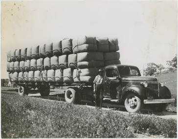
Photograph - Transporting Wool, 1960s
One of fifty one photographs originally in a photo album found in the National Wool Museum’s office. The album was water damaged and the images were removed for conservation. The images follow the process of wool. Beginning in a sheep paddock and finishing as a folded fabric. It includes all the steps in between in this process, including shearing, transporting, selling, washing and the many different steps in the process of turning a single thread of wool into fabric.Black and white image showing a man standing in front of a truck loaded with wool bales. The bales are being transported from Boorowa to Sydney.AUSTRALIAN NATIONAL PUBLICITY / ASSOCIATION / FLINDERS STREET RAILWAY BUILDING, / MELBOURNE AUSTRALIA / W40. Seventy bales of Wool going by motor vehicle from Boorowa to / Sydney.wool industry, working life, women, boonoke station, farming, sheep farming, agriculture, sheep stations, transport, wool processing, shearing, textile industry, wool -
 National Wool Museum
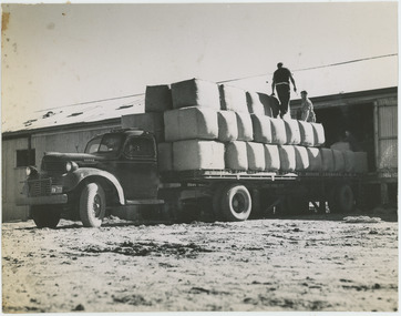
Photograph - Loading Wool Bales, 1960s
One of fifty one photographs originally in a photo album found in the National Wool Museum’s office. The album was water damaged and the images were removed for conservation. The images follow the process of wool. Beginning in a sheep paddock and finishing as a folded fabric. It includes all the steps in between in this process, including shearing, transporting, selling, washing and the many different steps in the process of turning a single thread of wool into fabric.Black and white image showing two men loading wool bales onto a motor transport vehicle.AUSTRALIAN NATIONAL PUBLICITY / ASSOCIATION / FLINDERS STREET RAILWAY BUILDING, / MELBOURNE AUSTRALIA / W68 / W68. Loading wool bales on to / a motor transport.wool industry, working life, women, boonoke station, farming, sheep farming, agriculture, sheep stations, transport, wool processing, shearing, textile industry, wool