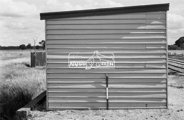
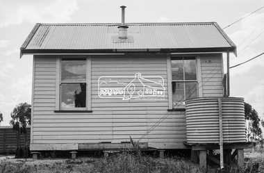
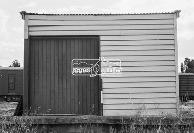
Showing 621 items matching "1870s"
-
 Warrnambool and District Historical Society Inc.
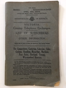
Booklet, Victorian Country telephone exchanges 1923, 1923
This is a 1923 booklet containing information on the Telephone Exchanges and the lists of subscribers in the areas of Geelong, Camperdown, Casterton, Hamilton, Mortlake, Portland and Warrnambool. Telephones were in use in Victoria as early as the 1870s with the first Telephone Exchange facility established in Melbourne in 1880. In 1890 the first Telephone Exchange in Warrnambool was established with 35 subscribers. In 1912 the first automatic Telephone Exchange for public use was established in Geelong. This was the second established in the British Empire. This booklet is of considerable importance as it lists all the telephone subscribers in the Warrnambool area in 1923. It is a great research tool as it gives not only the addresses of the subscribers but also in many instances their occupations and business names and in the areas around Warrnambool the names of the properties at that time. This is a soft-cover booklet of 104 pages. It has a dark grey cover with printed information on both sides. It was published in 1923. The pages are stapled together and contain lists of Telephone Exchanges, information on the distances from one Exchange to another in the area and the rates of charges for telephone trunk lines. It also has a list of subscribers in the Camperdown, Geelong, Hamilton and Warrnambool areas. The front cover has a small piece missing at the right hand side edge. There are some rubbing and dirt marks on the cover.Front Cover: ‘Victoria Country Telephone Exchanges, List of Subscribers And Other Information’warrnambool telephone exchange, 1923 telephone book, warrnambool -
 Phillip Island and District Historical Society Inc.
Photographs, Fuji Film, Pickersgill Family, c 1850's
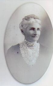
The Pickersgill family were the original settlers on Churchill Island, and amongst the earliest at Griffiths Point, now San Remo. Samuel Jabez Pickersgill, is the seventh of nine children of Samuel and Winifred Pickersgill of Churchill Island fame. Samuel Jabez lived from 1866 – 1956, and in his old age wrote down his memoirs of his early years in the 1870s and 1880s. Some of these are on the Phillip Island & District Historical Society website: www.pidhs.org.auSix Black & White photographs of possible members of the Pickersgill family. 255-01. Portrait of a lady - unknown, but member of Pickersgill family. Lady is possibly Mary (Anderson) Potter daughter of Thomas Anderson and Catherine Sayle. She was the wife of Rev Herbert Potter. Edith Potter from Herberts first marriage in England married Walter Pickersgill. 255-02. Photograph of a house - maybe Pickersgill connection. 255-03. Family group - lady with 5 children - possibly Pickersgill. 255-04. Samuel K Pickersgill with wife & child. 255-05. Samuel K Pickersgill. 255-06. Photograph of 5 ladies (sisters) Back Row: Mrs Annie Potter & Mrs Charles Grayden. Front Row: Mrs Priscilla Howse, Mrs Lil Beamish, Mrs Kate Thompson. The sister in the middle of the group was the eldest, Lil nee Pickersgill, who was born before the family settled on Churchill Island.pickersgill family, samuel k pickersgill, laurie thompson -
 Mission to Seafarers Victoria
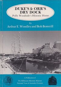
Book, Arthur E. Woodley et al, Duke’s & Orr’s Dry Dock, Polly Woodside’s Historic Home, 1985
70 pages : illustrations, facsimiles, mapsnon-fictionduke and orr dry dock, polly woodside, national trust, yarra river, south wharf, interest group -
 Eltham District Historical Society Inc
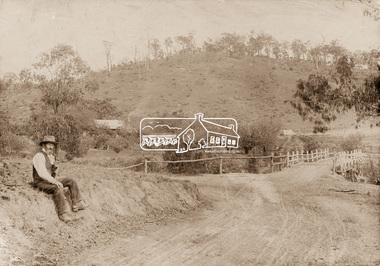
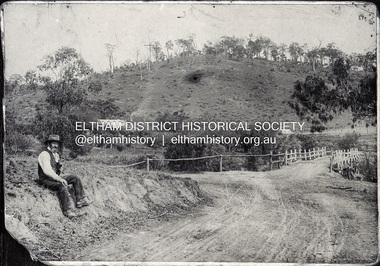
Photograph, Mr Belot smokes his pipe whilst resting at Cottle's Bridge, c.1890
The area, previously known as Back Creek, was named after Thomas Cottle, who settled in the district in the 1870s, and the original bridge over the Diamond Creek on the road to Strathewen. The original bridge (seen in the photo) was replaced with a new timber bridge at a cost of £1,500, the tender being awarded to a contractor named Birch who commenced work in June 1927. The gentleman in the photo who is resting whilst having a smoke of his pipe is a member of the Belot family.Original sepia photograph mounted on card broken lower left corner and cracked upper rightbelot, bridge, cottles bridge, cottles bridge-strathewan road, diamond creek (creek), heidelberg-kinglake road -
 Bacchus Marsh & District Historical Society
Map, Tracing of plan shewing portion through Bacchus Marsh District of proposed new Main Road between Gisborne and Blackwood
Road construction and planning was a primary function of the early local government authorities in rural and regional Victoria. This plan is indicative of the sort of documentation which generated considerable public interest and comment in rural communities. The date of this plan is not clear. Newspaper articles in the Bacchus Marsh Express around 1869 contain numerous references to the proposed new road between Gisborne and Blackwood which suggests this plan may date from the late 1860s or early 1870s.A single page paper map showing the proposed route of a main road to be constructed between Gisborne and Blackwood. The map is pasted into a bound volume containing 76 maps or plans in total. High resolution digital image stored on BMDHS computer network. roads, road plans, bacchus marsh victoria maps, gisborne to blackwood main road -
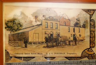 Charlton Golden Grains Museum Inc
Photograph - Lithograph, Rider & Mercer, Views of Charlton
Close up photograph of part of the Charlton Lithograph showing the Charlton Steam Power Flour Mill of G & C Foreman. Located in on the bank of the Avoca river. The mill owners attempted to dam the river during the 1870s. The mill was built in 1876 as recorded by the local traveling correspondent . Foreman's flour mill established 1876 at the west end of High Street. Sold to Norske in 1925. Replaced by Noske's Flour Mill on Kays Street in 1927.Colour photo taken of a small portion of the Charlton Lithograph. Showing the Charlton Steam Flour Mill of G. C. Foreman.Charlton Steam Flour Mills. G & C Foreman proprietors.lithograph, business, industry, charlton, flour mill, noske bros, foreman -
 Kew Historical Society Inc
Photograph - Demolishing the Zig-Zag Bridge, 1929
Henry Beater Christian (1886-1962) , was a descendant of one of the earliest settler families in Kew. Employed at the Kew Asylum as a 'public servant', he was a skilled amateur photographer, photographing numerous scenes in Kew and on his travels around Victoria. The majority of his photographs date from 1916 to 1929. His finest photographs are housed in two photograph albums. Rare photograph of the demolition of the Zig-Zag Bridge linking the two asylums on either side of the Yarra River.Digital copy of a photograph from page 16 of the 47-page photograph album containing 261 gelatinous silver images, loaned by Diane Washfold with permission given to digitise and hold a copy in our collection. The Zig-Zag Bridge linked the grounds of the Yarra Bend and Kew Asylums. The wooden bridge was constructed in the 1870s and lasted through numerous floods until its destruction in 1929. A horizontal structure, the walkway was reached via a wooden staircase on the Kew bank of the river. The steps were required due to the different levels of the banks on this stretch of the river. This night-time photograph shows the remaining parts of the bridge being destroyed by fire."Demolishing Zig-Zag / 6. 1929"henry beater christian (1886-1962), landscape photography, kew (vic.) — yarra river, christian-washfold collection, photograph albums, zig-zag bridge -
 Bendigo Historical Society Inc.
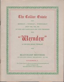
Book - AUCTION CATALOGUE: THE COLLIER ESTATE, 1954
Catalogue. 30 page catalogue of 995 items for auction from 'Werndew' the Collier Estate mansion at 65 Irving Rd, Toorak on 12, 13, and 14 July 1954. Auctioneers- Beauchamp Bros. Collins St., Melbourne. Attached and loose are numerous newspaper articles (1954) about the Collier mansion and family. Jenkin Collier (d.1921) left his fortune, made in the 1870s building boom, to his 3 unmarried daughters who lived in 'Werndew'. Annette Collier died 1947, aged 82. Alice Collier died 1950, aged 86. Edith Collier died 1954, aged 84.Beauchamp Bros. - auctioneersheritage, collier estate, jenkin collier, werndew, auction, annette collier, alice collier, edith collier -
 Warrnambool and District Historical Society Inc.
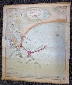
Map - Warrnambool Port 1879, 1879
The port facilities in Warrnambool Bay were in constant use from the first years of Warrnambool’s settlement but there were also difficulties for the shipping trade – a small and unsafe anchorage, the lack of loading facilities and little natural protection from the southerly gales. From the 1870s on there was local agitation for some sort of Breakwater to be built and an Andrew Kerr design was approved by the Warrnambool Council but no funds were made available from the Victorian Government. Throughout the 1870s the building of a Breakwater was a major political issue in the district with preliminary work being funded and started in 1874. In 1879 the Government agreed to a further inspection of the area and an official report. Sir John Coode (1816-1892) was commissioned to make this report. He had come to Australia in 1872 to advise on harbour construction. Coode recommended a 1800 feet long Breakwater and wharf connected to the shore and it was this proposal that the plan described herein and drawn up in 1879 was to accompany. The original plan was eventually modified because of the cost and a Breakwater was completed in 1890 under the direction of the engineer, Arthur Dudley Dobson, with extensions early in the 20th century. This plan is of great interest as it shows in simple graphic form the original plans proposed by Sir John Coode for the Warrnambool Breakwater. It is therefore of great historical importance. The Breakwater was not the maritime success that it was hoped it would be but it is today a significant feature of our foreshore. This is a Plan drawn up in 1879 by Victorian Harbours to accompany Sir John Coode’s Report on the proposed Warrnambool Breakwater. The chart detail is hand-drawn and hand-tinted on canvas with the names of places, geographical and marine features and local points of interest added in print. The edges of the chart are rubbed and the chart is somewhat faded and dirty but the main colours of red, green and brown are still clearly discernible. The title of the plan is printed in an oval inset at the top of the chart. The plan shows two possible Breakwater designs, one from the Borough Surveyor (Andrew Kerr?) and one from Sir John Coode.Victorian Harbours Warrnambool Plan to accompany Sir John Coode’s report Dated 28th Feby 1879 warrnambool breakwater, andrew kerr, sir john coode, arthur dudley dobson, warrnambool, warrnambool harbour, warrnambool history, warrnambool beach -
 Warrnambool and District Historical Society Inc.
Glass Slide Holder, Early to mid 20th century
This box has been used to store photographic glass slides. Since the 1850s glass slides or lantern slides have been used in photography and were particularly popular from the 1870s on. They preceded photographic film and were eventually eclipsed by the 35 mm. colour slides produced by Kodachrome in the mid 20th century. Glass slides, however, were still in use up to the 1990s in some scientific areas such as astronomy because of the stability of glass ware. This container has no known local provenance and is retained for display purposes.This is a brown varnished wooden container made in a rectangular shape. It is hinged at one end with two metal hinges and has two metal clips on the sides to keep the container closed. There are also two metal clips at the top perhaps for storage purposes. The inside has a flat black painted surface top and bottom and a loose black paper in one section. ‘3’vintage photography, history of warrnambool -
 Kew Historical Society Inc
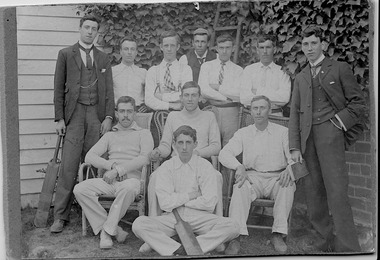
Photograph, First XI, Kew Cricket Club, 1913
The first cricket club in Kew in was formed in 1863, and played its matches in Wellington Street, and then later in O’Shaughnessy’s Paddock. In the early 1870s, a second club was formed and played at Victoria Park. The Kew Cricket Club gained its permanent name in 1888-89. One of the named players in the photograph - Albert Watson - was the son of the local Methodist Minister. The photograph entered the collection within a donation of items by Mrs Joy Ivory, a descendant of the Watson family, and a member of the Society.The photograph, dating from 1911 has local significance as an image of participation in sport and recreation.A monochrome photograph, mounted on card of the Kew Cricket Club's first XI cricket team in 1911. Annotations on the reverse identify three of the players: Standing left with bat: George Twycross; standing right: Albert Clements; Seated third on right: Albert Watson.Presented to Kew Historical by Mrs Ivory (nee Watson) Kew Cricket Club / Standing left with the bat Mr George Twycross / Standing right Mr Bert Clements / Seated third on right Mr Albert Watson / Year 1913kew cricket club (vic), sport - kew - victoria, albert watson, albert clements, george twycross -
 Bacchus Marsh & District Historical Society
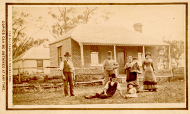
Photograph, Tom Oliver and family at Woodside, Parwan 1883
The family in this photograph is believed to be the Oliver family. Thomas Oliver, a farmer, advocated for a school at Parwan near Bacchus Marsh. This image depicts him and members of his family at his property, Woodside in 1883. The Woodside property was formerly owned by John Cook. The Olivers lived at Woodside during the 1870s and 1880s. Thomas Oliver retired around 1888 and moved to 'Elam's Cottage' in Bacchus Marsh. Three months after moving to Bacchus Marsh he died.Small sepia unframed photograph on card with gold border framing photograph. Housed in the album, 'Photographs of Bacchus Marsh and District in 1883 by Stevenson and McNicoll'. An image depicting a family group in front of a farm house. There are three men, two women and two small children standing or lying on a grassed area in front of the house, which has a post-and-rail fence. The farmhouse is a simple rectangular- shaped brick house with two chimneys and a tiled or slate roof. Behind the house can be seen a second building, also one-storeyed with a tiled or slate hip roof. On the front: Stevenson & McNicoll. Photo. 108 Elizabeth St. Melbourne. COPIES CAN BE OBTAINED AT ANY TIME. On the back: LIGHT & TRUTH inscribed on a banner surmounted by a representation of the rising sun. Copies of this Portrait can be had at any time by sending the Name and Post Office Money Order or Stamps for the amount of order to STEVENSON & McNICOLL LATE BENSON & STEVENSON, Photographers. 108 Elizabeth Street, MELBOURNE. stevenson and mcnicoll 1883 photographs of bacchus marsh and district, farms, farmers, oliver family parwan vic. -
 Eltham District Historical Society Inc
Negative - Photograph, Mr Belot smokes his pipe whilst resting at Cottle's Bridge, c.1990 (c.1890)
Copy of original photograph. The area, previously known as Back Creek, was named after Thomas Cottle, who settled in the district in the 1870s, and the original bridge over the Diamond Creek on the road to Strathewen. The original bridge (seen in the photo) was replaced with a new timber bridge at a cost of £1,500, the tender being awarded to a contractor named Birch who commenced work in June 1927. The gentleman in the photo who is resting whilst having a smoke of his pipe is a member of the Belot family.Roll of 35mm Black and White negative film, 3 strips, (1 of 14 frames)Film - Agfa Ortho 25belot, bridge, cottles bridge, cottles bridge-strathewan road, diamond creek (creek), heidelberg-kinglake road -
![High Street, East Kew [looking west], 1977](/media/collectors/550653872162f11fb04854aa/items/586f8bbfd0ce0e07f06d22ed/item-media/586f8c3ad0ce0e07f06d44cc/item-fit-380x285.jpg) Kew Historical Society Inc
Kew Historical Society IncPhotograph, High Street, East Kew, 1977
The Kew Historical Society's Pictures Collection is comprised of photographs and original works of art. The photographs include original (mainly) images dating from the 1870s to the present. A number of these photographs derive from the former City of Kew's Civic Collection while others are the work of amateur and professional photographers. Most of the images in the collection depict people, places and objects within the suburbs of Kew and Kew East. Other photographs depict other locations in Melbourne and Victoria. A number of the photographs are of statewide and/or national significance.View from junction of High and Strathalbyn Sts., Kew East, looking approximately west toward Cemetery, October 1977. Inscription reverse: "KH-72. View from junction of High St. & Strathalbyn Sts, Kew E. Looking approx. west, towards Cemetery. October 1977."high street -- kew (vic.), streetscapes -- kew (vic.) -
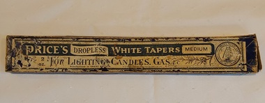 Mont De Lancey
Domestic object - Candle Tapers, Price's Patent Candle Company. Limited, c 1880 - 1910
Before electricity, candles were a primary source of light. They were used to light dinner tables, grand dining halls, and other formal settings. Tapers were essentially wax-coated wicks used to light gas or kerosene appliances or candles. Price's developed its 'Ship Brand' trademark in the 1870s, featuring the image of a clipper ship under sail. Price's candle tapers were made between 1880 and 1910. Price's Candles was founded in 1830 by William Wilson. A long thin vintage rectangular cardboard box of three pieces of used thin Price's Dropless White Tapers Medium, for lighting candles, gas etc. The lid is heavily patterned with blue and white product name and information. The base and the sides have no writing. Manufactured in Great Britain. Inside a patterned circle on the right is 'Price's Patent Candle Company. Limited London & Liverpool.'candles, lighting equipment, tapers, gas lighters -
 Kew Historical Society Inc
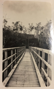
Photograph - Zig-Zag Bridge, 1924
Henry Beater Christian (1886-1962) , was a descendant of one of the earliest settler families in Kew. Employed at the Kew Asylum as a 'public servant', he was a skilled amateur photographer, photographing numerous scenes in Kew and on his travels around Victoria. The majority of his photographs date from 1916 to 1929. His finest photographs are housed in two photograph albums. Digital copy of a photograph from page 8 of the 47-page photograph album containing 261 gelatinous silver images, loaned by Diane Washfold with permission given to digitise and hold a copy in our collection. The Zig-Zag Bridge linked the grounds of the Yarra Bend and Kew Asylums. The wooden bridge was constructed in the 1870s and lasted through numerous floods until its destruction in 1929. A horizontal structure, the walkway was reached via a wooden staircase on the Kew bank of the river. The steps were required due to the different levels of the banks on this stretch of the river. The photo is taken from the Kew side of the river and shows clearly the width of the walkway on top of the bridge. "Zig-Zag Bridge"henry beater christian (1886-1962), landscape photography, kew (vic.) — yarra river, christian-washfold collection, photograph albums, zig-zag bridge -
 Kew Historical Society Inc
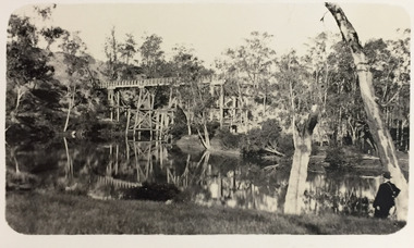
Photograph - Demolishing the Zig-Zag Bridge, 1929
Henry Beater Christian (1886-1962) , was a descendant of one of the earliest settler families in Kew. Employed at the Kew Asylum as a 'public servant', he was a skilled amateur photographer, photographing numerous scenes in Kew and on his travels around Victoria. The majority of his photographs date from 1916 to 1929. His finest photographs are housed in two photograph albums. Rare photograph of the demolition of the Zig-Zag Bridge linking the two asylums on either side of the Yarra River.Digital copy of a photograph from page 16 of the 47-page photograph album containing 261 gelatinous silver images, loaned by Diane Washfold with permission given to digitise and hold a copy in our collection. The Zig-Zag Bridge linked the grounds of the Yarra Bend and Kew Asylums. The wooden bridge was constructed in the 1870s and lasted through numerous floods until its destruction in 1929. A horizontal structure, the walkway was reached via a wooden staircase on the Kew bank of the river. The steps were required due to the different levels of the banks on this stretch of the river. This is a photo of the bridge before part of it was destroyed in a flood in 1929. A man, perhaps Henry Christian, stands at the right of the foreground."Demolishing Zig-Zag / 6. 1929"henry beater christian (1886-1962), landscape photography, kew (vic.) — yarra river, christian-washfold collection, photograph albums, zig-zag bridge -
 Warrnambool and District Historical Society Inc.
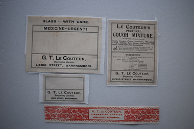
4 Labels, Le Couteur Chemist, Early 20th Century
In 1896 George Le Couteur succeeded Frank Uren in the Liebig Street chemist shop that had been established by James Astley Bromfield in 1876. Le Couteur had been an apprentice with Michael Ryan in Timor Street in the early 1870s. Le Couteur had his own medicines including his Pectoral Cough Mixture ( selling in bottles for 2 shillings and sixpence) which he claimed acted as a preventative for that "dread disease consumption ". In 1907 Le Couteur sold the business and moved to Melbourne. These labels are of interest as George Le Couteur was an important chemist in Warrnambool ate the end of the 19th century and the early 20th century..1 Cream coloured rectangular label with black text adhered to a piece of white paper. .2 Buff coloured rectangular label with black text adhered to a piece of white paper. .3 Buff coloured rectangular label with red text and decoration of berries .4 Buff coloured rectangular label with black text adhered to a piece of white paper.1 GLASS -- WITH CARE MEDICINE --URGENT G.T LE COUTEUR .1GLASS --WITH CARE MEDICINE --URGENT G.T. LE COUTEUR Dispensing Chemist LIEBIG STREET, WARRNAMBOOL .2 LE COUTEUR'S PECTORAL COUGH MIXTURE with text detailing conditions for which it offers to cure and directions for taking, .3 G.T LE COUTEUR DISPENSING CHEMIST LIEBIG STERRT, WARRNAMBOOL .4 G.T LE COUTEUR Dispensing Chemist LIEBIG STREET, WARRNAMBOOL le couteur, chemist, james bromfield, cough medicine, warrnambool chemists -
 Glen Eira Historical Society
Letter - Hart Family
Handwritten letter from Rodney Hart to Mr Ballantyne, Secretary of the Caulfield Historical Society donating a photograph of his grandfather John Hart and family in from of their Bambra Road house, letter dated 07/03/1984. Includes a black and white photograph with verso description “ John Hart’s home Bambra/Neerim Road, Caulfield 1858 L-R John Hart, wife Mary, mother Susannah. [Date incorrect: John married Mary in 1864, Susannah died in 1875 so it is most likely dated 1870s]hart rodney, hart john, hart mary, hart susannah, ballantyne r, caulfield historical society, bambra, neerim road, caulfield, brick houses, architectural styles -
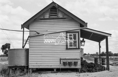
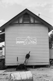
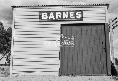
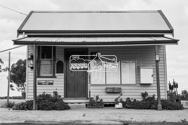 Eltham District Historical Society Inc
Photograph, Barnes Railway Station, Moama, NSW, c.November 1962, 1962
The railway reached Echuca in 1864 and transformed the town into a major river port, with a famous wharf and substantial urban growth in the 1870s. In 1876 the Deniliquin and Moama Railway Company opened its 71 km (44 mi) private railway northwards to Barnes and Deniliquin, and the line at Echuca was extended across the Murray River into Moama to join the railway. This section was taken over by Victorian Railways in 1923, as part of the 1922 Border Railways Act. Barnes station was closed in 1979. Deniliquin railway line https://en.wikipedia.org/wiki/Deniliquin_railway_lineDigital TIFF file Scan of 35mm Ilford FP3 black and white negative transparencybarnes railway station, echuca, george coop collection, moama -
 Greensborough Historical Society
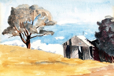
Painting - Digital image, Barn at Willis Vale, 1920c
Painting of a barn at Willis Vale. 'Willis Vale' was owned and farmed by the Partington family from the 1870s. The derelict Willis Vale house was destroyed in 1964 when a fire originating from North Plenty Gorge - Kurrak Road - was lit by two teenage boys and made its way several kilometres down to Partington's Flat Greensborough. Gary Partington thought the barn was probably associated with the bull yard. (Note: Only some abandoned stumps existed when Gary was very young in the mid to late 1940s) Digital copy of painting.willis vale, partington family -
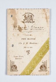 City of Greater Bendigo - Civic Collection
Memorabilia - Event Program, City of Bendigo, Mayor Dinner, 1902
John Robert Hoskins was a Councillor with the City of Bendigo from1888 - 1902 and Mayor from 1901 - 1902. Hoskins' interests in the region included the mining company Hoskins & Co, which distinguished itself on the late Derwent Reef United Company's leased ground in 1868 by achieving a yield of over an ounce to the ton. In the late 1870s John R. Hoskins formed a estate agency in partnership with Frederick Illingworth. He was also manager of the New Nil Desperandum, formed to work the shaft of the old Raywood mine, from 1906 to 1908. Event program for the Mayoral Dinner July 25, 1902. Gold, green and brown ink on cream card. Half fold with menu printed inside and Toast List on back cover. Scalloped edges.Front cover: (Picture) Bendigo Coat of Arms / Mayoral Dinner / Given by / The Mayor / (Cr .J. R. Hoskins) / July 25, 1902 / Town Hall / Bendigo bendigo town hall, making a nation exhibition, c roberts caterer, mayor j. r. hoskins, councillor j. r hoskins, mayoral ball, city of greater bendigo events, city of greater bendigo ceremonial item -
 Hymettus Cottage & Garden Ballarat
Book, Shakespeare's Stories
This Book was presented for fancy work to Miss Annie Wilson in 1882 with A. Bain as School Principal. It has a premium plate with presentation details on the verso of the front cover. It together with an earlier book from the same school helps trace the history of the school from its origins as Alex Bain's Camp St School in the 1870s through to its renaming as the High School Ballarat pre-dating the later Education Department's Ballarat Agricutural High School re-named Ballarat High School in the early twentieth century.Identifies personalities and principles of excellence in education in nineteenth century Ballarat. -
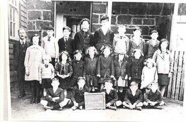 Hume City Civic Collection
Photograph, Bulla State School, 1930
The class photograph was taken at the Bulla State School No. 46 in 1930. Two children have been identified. They are John Daniel, seated in the front row, second from the left. Vincent Daniel is standing, first on the left in the back row. The Daniel family were store holders in the Bulla township. Over the years a teacher's residence and another larger weatherboard classroom were added to the original bluestone building. The school functioned for over 100 years from the late 1870s until 2006 when it was closed and is now a private house.The Bulla State School was one of the oldest schools in the district and served the children from surrounding areas. A black and white school photograph which has been photographed from another image. The twenty two children of twelve boys and ten girls are in three rows and standing in front of a bluestone building with their teacher.bulla state school no46, daniel john, daniel vincent, schools