Showing 1066 items matching "boundary"
-
 Eltham District Historical Society Inc
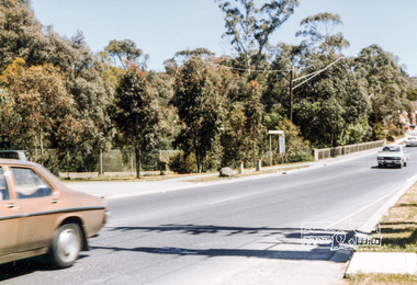
Photograph, Para Road Bridge over the Plenty River at Briar Hill, Jan 1986, January 1986
Boundary of Eltham and Diamond Valley Shires looking northRoll of 35mm colour negative film, 3 stripsKodak CL 200 5093bridge, para road, briar hill -
 Eltham District Historical Society Inc
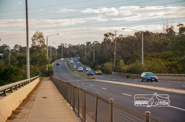
Photograph, Looking north from Fitzsimons Lane Bridge, c.May 2001
Viewed from the boundary of Eltham, Lower Plenty and TemplestoweRoll of 35mm colour negative film, 7 stripsAgfa HDC 200 plus-2eltham, streets, main road, fitzsimons lane, fitzsimons lane bridge -
 Peterborough History Group
Document - Maps, tourist information
Council boundaries, past tourist information, past mapsHistoric town information and mapsPhotocopies, copies of maps, newspaper clippingpeterborough history, peterborough 3270 -
 Bendigo Historical Society Inc.
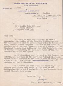
Document - AILEEN AND JOHN ELLISON COLLECTION: LETTER COMMONWEALTH ELECTORAL OFFICE
Letter dated 30th July, 1969 from the Commonwealth of Australia, State of Victoria, electoral office for the division of Bendigo, 45 bull Street, Bendigo addressed to Mr. Leslie John Ellison, 15 Archer Street, Kangaroo Flat, 3555. The letter advise Mister Ellison that due to changes in the federal electoral boundaries Archer Street is now in the Golden Square subdivision but because by-elections must be held on the boundaries of the previous federal election, Archer Street reverted to the subdivision of Marong.government, federal, electoral office -
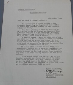 Bendigo Historical Society Inc.
Document - Technical school in Bendigo
BHS CollectionTypewritten letter from the Bendigo Inspectorate placement committee to the heads of Primary schools advising them of the change to the boundary between the two technical school. Attached to the letter two drawing showing in the first the area covered by the white Hills technical school and the Kangaroo Flat technical school and in the second the Bendigo, Golden Square and Eaglehawk High School boundaries. The letter is dated 19th July 1968 and signed by W.F.R Budge (District Inspector of Schools) Aileen and John Ellison Collection.technical school, white hills technical, kangaroo flat technical -
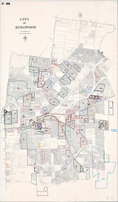 Ringwood and District Historical Society
Map, City of Ringwood - Rateable Properties Layout - c.1966
A0-size (approx) map of named streets, lot-numbered properties and locality features within City of Ringwood boundary. Coloured outlines of subsequent subdivisions. Seperate enlargement showing northern half of map.Scale: 8 chains to 1 inch. -
 Whitehorse Historical Society Inc.
Photograph, Narmara Primary School, 13/01/1994 12:00:00 AM
Coloured photo of Narmara Primary School looking North along East boundary. School on North side of Highbury Road between Middleborough Road and Blackburn Road. Since demolished and site developed for housing.narmara primary school, warner, philip -
 St Patrick's Old Collegians Association (SPOCA)
Photograph - Buildings, SPJC, Exterior, 1850s Image
-
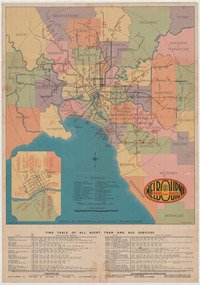 Melbourne Tram Museum
Ephemera - Map - Timetable, Melbourne & Metropolitan Tramways Board (MMTB), "Map and timetable of Melbourne Tram and Bus Services", March 1952
Map provided information about Melbourne's tramway network in 1952. At base of map - timetable of all night trams and bus services. On rear index to routes, 1st and last services, time of Sunday am services, Latrobe St. services and photo of Wattle Park. The conversion of Bourke St to electric trams marked up. Copy 1 - has been marked for hypothetical extensions in blue pencil mainly in the northern and western suburbs. In particular note the Ballarat Road and South Road markings. Copy 2 - has been marked up for newer route numbers, following the opening of the Bourke St services and additional route numbers on the Essendon Depot lines. Demonstrates the provision of information about Melbourne tram services.Fold out map (10 sections - 2 high x 5 wide), coloured of Melbourne's Tram and Bus routes, route numbers, rail lines, municipalities boundaries and location of major places of interest. melbourne, tram and bus services, mmtb, buses, trams, routes, timetables, all night services -
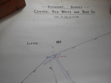 Bendigo Historical Society Inc.
Administrative record - Central Red White and Blue Mine Map
Draftsman's drawing Boundary Survey of Central Red White and Blue Co Map. Handwritten signature of Garnet G Buich, Licensed Mining Surveyor Forms part of the Margaret Roberts Collection of mining records.bendigo, margaret roberts, gold, map, mine, central red white and blue -
 Whitehorse Historical Society Inc.
Photograph - ColouredPhotograph, Narmara Primary School, 13/01/1994 12:00:00 AM
Coloured photo of Narmara Primary School, looking North from south boundary. School on North side of Highbury Road between Middleborough Road and Blackburn Road. Since demolished and site developed for housing.narmara primary school, warner, philip -
 Eltham District Historical Society Inc
Negative - Photograph, J.A. McDonald, Buttermans Track, St Andrews, April 1962
Looking to culvert from Crosby's boundary Circa April 1962Record of various Shire of Eltham infrastructure works undertaken during the period of 1952-1962 involving bridge and road reconstruction projects, sometimes with Eltham Shire Council Project Reference numbers quoted. It was during this period that a number of significant improvements were made to roads and new bridges constructed within the shire that remain in place as of present day (2022). In many situations, the photos provide a tangible visible record of infrastructure that existed throughout the early days of the Shire. The album was put together by or under the direction of the Shire Engineer, J.A. McDonald.1962-04, buttermans track, infrastructure, shire of eltham, st andrews, bridge construction -
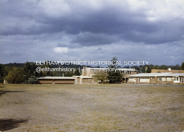
 Eltham District Historical Society Inc
Colour Print, David Taylor, Maurie Fabbro's home viewed from the rear of Eltham High School, c.1976
Viewed from the near the basketball court at the western boundary of the schooldavid taylor collection, eltham, eltham high school, fabbro's farm -
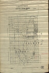 Federation University Historical Collection
Plan - map, Ascot: Counties of Ripon and Talbot, 18/12/1920
Cadastral map showing parish boundaries and land ownership. "L5270"Maps parishes located in Ascot area. Photo-Lithographed at the Dept. of Lands and Survey.Highlighted parish labelled, Mrs E.C.Sutherland.parish, map, ascot, counties, e. c. sutherland, a. cameron, sweeney, w. j. clarke, mount hollowback, tourello, burrumbeet, glendaruel, dowling forest, a. j. mullett, w. j. butson, 1920, william coghill, chatham, chatham family collection, mrs e.c.sutherland. -
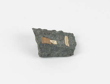 The Beechworth Burke Museum
Geological specimen - Greenstone / Gabbro, Unknown
This specimen was recovered from Ceres West of Geelong, Victoria. Greenstone is the name for any metamorphosed basic igneous rock (in the case of this specimen, Gabbro) that gains its greenish colour to the presence of the minerals chlorite, actinolite, or epidote, hence the term 'green' and 'stone'. Greenstone is often formed through metamorphsis along a convergent plate boundary. In the rock cycle (the series of processes that creates the various types of rocks) there are identified three different types of rocks, which are the sedimentary, the igneous and the metamorphic. Metamorphic rocks started out as sedimentary, igneous or earlier metamorphic rocks but changed from their original condition under the effect of high heat, high pressure or hot, mineral-rich fluid. However, if pressure or heat is too high, then the rock will melt, resulting in the formation of an igneous rock. The name used to describe these types of rocks reflects this specific inherent trait of change, since the word “metamorphic” derives from the Greek word “metamorphosis”, meaning “change of form or structure”. Metamorphic rocks form in the Earth`s crust but can be also found on the surface, due to elevation of the Earth`s surface. They are divided into two categories: the foliated metamorphic and the non-foliated metamorphic rocks. Gabbro is a highly useful mineral that is often polished to create cemetery markers and kitchen benches. It is notable for its qualities of durability, being able to withstand extreme elements and wear. Whilst not rare, Gabbro is of great utility and has been highly desirable for its qualities. This specimen is part of a larger collection of geological and mineral specimens collected from around Australia (and some parts of the world) and donated to the Burke Museum between 1868-1880. A large percentage of these specimens were collected in Victoria as part of the Geological Survey of Victoria that begun in 1852 (in response to the Gold Rush) to study and map the geology of Victoria. Collecting geological specimens was an important part of mapping and understanding the scientific makeup of the earth. Many of these specimens were sent to research and collecting organisations across Australia, including the Burke Museum, to educate and encourage further study.Greenstone is a solid hand-sized metamorphic mineral of a green colour. Greenstone is the name for any metamorphosed basic igneous rock (in the case of this specimen, Gabbro) that gains its greenish colour to the presence of the minerals chlorite, actinolite, or epidote, hence the term 'green' and 'stone'. Gabbro is a medium to coarse grained rocks that consist primarily of plagioclase feldspar and pyroxene. Greenstone is often formed through metamorphsis along a convergent plate boundary. Gabbro forms due to cooling and crystallization of magma underneath Earth's surface. Greenstone/Gabbro/from Ceres west/of Geelong. Has old Geological Survey label/and probably collected by/Richard Daintree in 1861/C.Willam 15/4/21/ Other label: 62 /greenstone, metamorphosed, igneous rock, gabbro, chlorite, actinolite, epidote, metamorphsis, rock cycle, various types of rocks, sedimentary, high heat, high pressure, mineral-rich fluid, metamorphosis, foliated metamorphic, non-foliated metamorphic, convergent plate boundary, greenish colour, minerals -
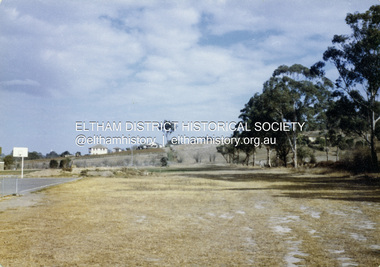
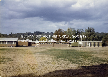
 Eltham District Historical Society Inc
Colour Print, David Taylor, Maurie Fabbro's home viewed from the rear of Eltham High School, c.1976
Viewed from the near the western boundary of the school near the Athletic fielddavid taylor collection, eltham, eltham high school, fabbro's farm -
 Eltham District Historical Society Inc
Colour Print, David Taylor, Maurie Fabbro's home viewed from the rear of Eltham High School, c.1976
Viewed from the near the western boundary of the school near the Athletic fielddavid taylor collection, eltham, eltham high school, fabbro's farm -
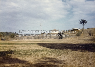
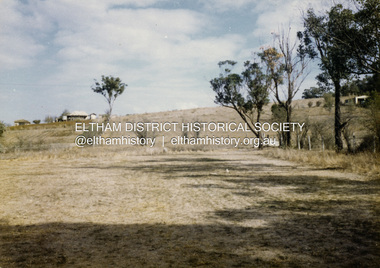
 Eltham District Historical Society Inc
Colour Print, David Taylor, Eltham High School Athletic Field, c.1976
Viewed from the school's western boundary looking across the Athletic Fielddavid taylor collection, eltham, eltham high school -
 Eltham District Historical Society Inc
Colour Print, David Taylor, Eltham High School Athletic Field, c.1976
Viewed from the school's western boundary looking across the Athletic Fielddavid taylor collection, eltham, eltham high school -
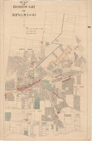 Ringwood and District Historical Society
Map, Borough of Ringwood, Victoria - c.1950s
A0-size (approx) map of named streets and lot-numbered properties within Borough of Ringwood ward boundaries. Colour-coded key marking Land Under Control of Council, Factory Areas, and Business Areas.Scale: 8 chains to 1 inch. North Ward, East Ward, South Ward. -
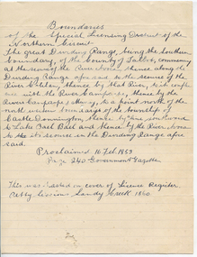 Tarnagulla History Archive
Handwritten statement: District boundaries, Boundaries, unknown
Murray Comrie Collection. A handwritten statement on lined paper relating to boundaries of the Special Licensing District of the Northern Circuit (court). Note on lower section states that the statement 'was pasted on cover of License Register Petty Sessions Sandy Creek 1860'.tarnagulla, court, petty sessions, licensing -
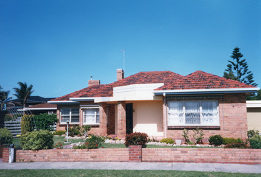 Lakes Entrance Historical Society
Photograph - Historic House, 2000
Built soon after WW11 by Fred Moore for Reg and Hazel Bulmer, post war contemporary style, named 'Camelot'. Fred Moore, also built the Lakes Entrance Infant Welfare Centre, brick with tiled roof, of similar style, unfortunately demolished 1998.Colour photograph of a substantial brick dwelling with tiled hip roof, brick column supporting front porch, on the corner of Church Street. Low brick fence on boundary, at 16 Bulmer Street, Lakes Entrance Victoriafences, houses, heritage study -
 Greensborough Historical Society
Map, Victoria. Department of Crown Lands and Survey, Keelbundoora; Counties of Bourke and Evelyn, 1950c
Map of the Victorian counties of Bourke and Evelyn showing parish boundaries and land ownership.Show the original landholders for this area.Map on light brown parchment, covered in plastic."L.5305" and "3462" -
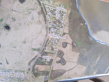 Peterborough History Group
Plan - Moyne Shire Council Aerial photograph, Department of Sustainability and Environment, January 2018
View shows development at the time and showing the town boundary using Vicmap InformationSignificant in that it provides a record of the current state of development of the town. Also, a view of the estuary at that time.A3 size copy of an aerial view of the majority of the town with street names mentioned. curdies river inlet, peterborough, aerial view -
 Glenelg Shire Council Cultural Collection
Photograph - Photograph - Hanlon Park, Portland, n.d
Black and white photo of a football match at Hanlon Park, Portland, taken from north side of ground, looking south. Spectators can be seen behind white boundary fence, some footballers close to fence on that side.Back: Round purple stamp: 'PRINTED BY M.E. ANDREWS, PORTLAND' 'Scene of Football Match Portland V Casterton Federal' 'Attendance 400' - handwritten in black inkhanlon park, recreation, football, local sport -
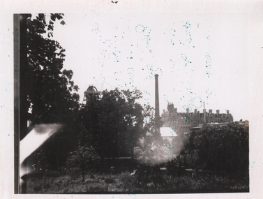 Bendigo Historical Society Inc.
Photograph - HUSTLER'S ROYAL RESERVE (PARK) GOLD MINE BENDIGO
Black and white photograph, poor quality. Image shows chimney and top of poppet head of Hustler's Royal Reserve Gold Mine, on boundary of (now) Rosalind Park, Bendigo. Shamrock Hotel visible in RH background of photo.bendigo, mining -
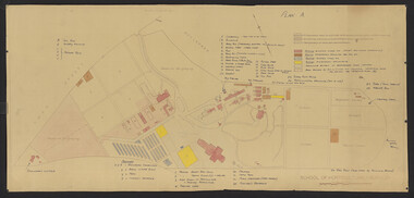 University of Melbourne, Burnley Campus Archives
Plan - Coloured plan, Thomas H. Kneen, School of Horticulture - Burnley, 1948-1949
Colour-coded to show existing and proposed buildings, numbered and lettered to indicate use of buildings Related documents: B91.476, B91.484Plan with handwritten amendments by T.H. Kneen on 24.10.1949. Extensive explanation of existing and proposed structures at the College. Plan A: area bounded by Swan St., Yarra Boulevard, reserves for grazing, orchard and vegetable gardens along southern boundary. Amended 24/10/49 T.H. Kneent.h. kneen, burnley gardens, burnley school of horticulture, farm buildings -
 Eltham District Historical Society Inc
Negative - Photograph, J.A. McDonald, Rattray Road East, Montmorency, 8 May 1961
From south boundary lot looking along proposed alignment 1 May 1961Record of various Shire of Eltham infrastructure works undertaken during the period of 1952-1962 involving bridge and road reconstruction projects, sometimes with Eltham Shire Council Project Reference numbers quoted. It was during this period that a number of significant improvements were made to roads and new bridges constructed within the shire that remain in place as of present day (2022). In many situations, the photos provide a tangible visible record of infrastructure that existed throughout the early days of the Shire. The album was put together by or under the direction of the Shire Engineer, J.A. McDonald.infrastructure, montmorency, rattray road, road construction, shire of eltham, 1961-05-08 -
 Eltham District Historical Society Inc
Negative - Photograph, J.A. McDonald, Rattray Road East, Montmorency, 1 May 1961
From south boundary lot looking along proposed alignment 1 May 1961Record of various Shire of Eltham infrastructure works undertaken during the period of 1952-1962 involving bridge and road reconstruction projects, sometimes with Eltham Shire Council Project Reference numbers quoted. It was during this period that a number of significant improvements were made to roads and new bridges constructed within the shire that remain in place as of present day (2022). In many situations, the photos provide a tangible visible record of infrastructure that existed throughout the early days of the Shire. The album was put together by or under the direction of the Shire Engineer, J.A. McDonald.1961-05-01, infrastructure, montmorency, rattray road, road construction, shire of eltham -
 Eltham District Historical Society Inc
Negative - Photograph, J.A. McDonald, Rattray Road East, Montmorency, 1 May 1961
From south boundary lot looking along proposed alignment 1 May 1961Record of various Shire of Eltham infrastructure works undertaken during the period of 1952-1962 involving bridge and road reconstruction projects, sometimes with Eltham Shire Council Project Reference numbers quoted. It was during this period that a number of significant improvements were made to roads and new bridges constructed within the shire that remain in place as of present day (2022). In many situations, the photos provide a tangible visible record of infrastructure that existed throughout the early days of the Shire. The album was put together by or under the direction of the Shire Engineer, J.A. McDonald.1961-05-01, infrastructure, montmorency, rattray road, road construction, shire of eltham