Showing 749 items
matching contractor
-
 Charlton Golden Grains Museum Inc
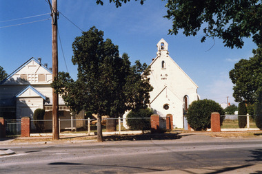
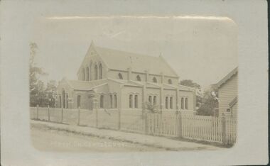
Photograph, Brownjohn, Reg, Charlton Presbyterian Church and Hall mid-1980s, c.1890
The Presbyterian Church was built in 1871 by local contractor and grazier James Patterson of Nardoo Park, Woosang. The Presbyterian and Methodist Churches formed combined Parish in 1969. The buildings were demolished in 1989.Colour photograph of Charlton Presbyterian Church and Hall. The white-painted brick church building is on the right. The letters A . D 1871 in black are on the front of the church. There is also a bell tower, a small gothic arched window and a small round leadlight window on the front wall. The church hall is a white weatherboard building with blue trim. Red brick pillars stand at the entrance to the church and the hall. A large electricity pole is in front of the hall. james patterson, charlton, presbyterian, church, pastoral care -
 Bendigo Historical Society Inc.
Document - MCCOLL, RANKIN AND STANISTREET COLLECTION: CENTRAL NAPOLEON GOLD MINING CO. N.L, 14th April 1949
Document: Letter to Mr J Stanistreet from Saunders & Russ Machinery and Building Contractors requesting to purchase two lengths of H girder 10 x 5 that are laying unused at the back of Central Napoleon's Battery for a sum of £20-0-0 per ton, document was found in the back of Central Napoleon GM N.L Minutes book number 2 which is now numbered 2205.712a.organization, business, industry - mining, mccoll rankin & stanistreet, mining, gold mining, central napoleon -
 Kew Historical Society Inc
Plan, Melbourne and Metropolitan Board of Works, Melbourne & Metropolitan Board of Works : Borough of Kew : Detail Plan No.1294 & 1295, 1904
The Melbourne and Metropolitan Board of Works (MMBW) plans were produced from the 1890s to the 1950s. They were crucial to the design and development of Melbourne's sewerage and drainage system. The plans, at a scale of 40 feet to 1 inch (1:480), provide a detailed historical record of Melbourne streetscapes and environmental features. Each plan covers one or two street blocks (roughly six streets), showing details of buildings, including garden layouts and ownership boundaries, and features such as laneways, drains, bridges, parks, municipal boundaries and other prominent landmarks as they existed at the time each plan was produced. (Source: State Library of Victoria). This plan forms part of a large group of MMBW plans and maps that was donated to the Society by the Mr Poulter, City Engineer of the City of Kew in 1989. Within this collection, thirty-five hand-coloured plans, backed with linen, are of statewide significance as they include annotations that provide details of construction materials used in buildings in the first decade of the 20th century as well as additional information about land ownership and usage. The copies in the Public Record Office Victoria and the State Library of Victoria are monochrome versions which do not denote building materials so that the maps in this collection are invaluable and unique tools for researchers and heritage consultants. A number of the plans are not held in the collection of the State Library of Victoria so they have the additional attribute of rarity.Original survey plan, issued by the MMBW to a contractor with responsibility for constructing sewers in the area identified on the plan within the Borough of Kew. The plan was at some stage hand-coloured, possibly by the contractor, but more likely by officers working in the Engineering Department of the Borough and later Town, then City of Kew. The hand-coloured sections of buildings on the plan were used to denote masonry or brick constructions (pink), weatherboard constructions (yellow), and public buildings (grey).The streets and built structures in MMBW Detail Plan 1294 & 1295 were surveyed in 1903 and released to contractors in 1904. This plan is one of two in the collection where the lithographers amalgamated two separate plans. Both plans include sections of Studley Park. Dominating the south and west corners of Kew Junction are the Clifton and Kew Hotels. The Kew Hotel, owned by Patrick O’Shaughnessy was one of the oldest in Kew. MMBW plans were amended over time to take account of new subdivisions such as that which created Merrion Place. Of the four mansions shown in Studley Park Road, three remain – ‘Field Place’, the home of Frances Henty, ‘Leaghur’ and ‘Darley’. ‘Byram’ (later ‘Goathland’, then ‘Tara Hall’) was an architectural marvel. Designed in 1888 by E.G. Kilburn for the paper magnate George Ramsden, it was demolished in 1960. While an earlier sale of the southern section of Byram had created Tara Avenue in 1927, the demolition of the house in 1960 enabled the extension of Tara Avenue northward.melbourne and metropolitan board of works, detail plans, mmbw 1294, mmbw 1295, cartography -
 Kew Historical Society Inc
Plan, Melbourne & Metropolitan Board of Works : Borough of Kew : Detail Plan No.1573, 1905
The Melbourne and Metropolitan Board of Works (MMBW) plans were produced from the 1890s to the 1950s. They were crucial to the design and development of Melbourne's sewerage and drainage system. The plans, at a scale of 40 feet to 1 inch (1:480), provide a detailed historical record of Melbourne streetscapes and environmental features. Each plan covers one or two street blocks (roughly six streets), showing details of buildings, including garden layouts and ownership boundaries, and features such as laneways, drains, bridges, parks, municipal boundaries and other prominent landmarks as they existed at the time each plan was produced. (Source: State Library of Victoria)This plan forms part of a large group of MMBW plans and maps that was donated to the Society by the Mr Poulter, City Engineer of the City of Kew in 1989. Within this collection, thirty-five hand-coloured plans, backed with linen, are of statewide significance as they include annotations that provide details of construction materials used in buildings in the first decade of the 20th century as well as additional information about land ownership and usage. The copies in the Public Record Office Victoria and the State Library of Victoria are monochrome versions which do not denote building materials so that the maps in this collection are invaluable and unique tools for researchers and heritage consultants. A number of the plans are not held in the collection of the State Library of Victoria so they have the additional attribute of rarity.Original survey plan, issued by the MMBW to a contractor with responsibility for constructing sewers in the area identified on the plan within the Borough of Kew. The plan was at some stage hand-coloured, possibly by the contractor, but more likely by officers working in the Engineering Department of the Borough and later Town, then City of Kew. The hand-coloured sections of buildings on the plan were used to denote masonry or brick constructions (pink), weatherboard constructions (yellow), and public buildings (grey). This plan has detailed annotations written in red or blue ink, showing prices, which may be the annual valuations of the properties, and some owners’ names, a most unusual feature on contractor's maps. Some areas, such as the buildings of Methodist Ladies’ College (MLC), include the school’s tennis court and swimming pool, but are not coloured to show building materials – did the draftsman just run out of time, or ink, or enthusiasm, before his plan had to be submitted? MLC had been founded in 1882 as a ‘modern school of the first order’ with buildings that formed ‘a collegiate institution for girls unsurpassed in the colonies’. The goal of its founders was to provide a high-class Christian education for girls, comparable with that provided elsewhere for boys. Some shops are shown along Edgevale Road, though they are not designated as commercial premises. Larger houses are depicted, including ‘Fairlawn’ in Barkers Road, and ‘Clevedon’ and ‘Rosehill’ (now demolished) in Fitzwilliam Street.melbourne and metropolitan board of works, detail plans, mmbw 1573, maps - borough of kew, cartography -
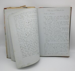
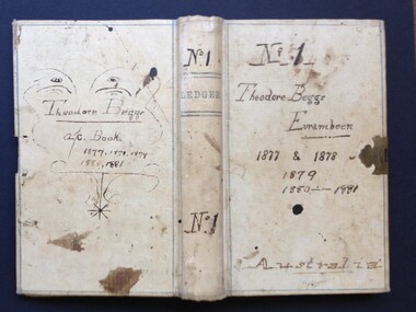 Beaufort Historical Society
Work on paper - Ledger, Theodore Beggs Eurambeen No. 1 1877-1881, 1877
Small, c. 7"x 4", 253 p., cloth boundeurambeen -victoria, beaufort - people, beaufort - history, pastoral industry - victoria, beggs family, chinese - beaufort -
 Charlton Golden Grains Museum Inc
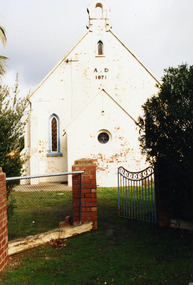
Photograph, Charlton Shire, St Andrews Charlton Presbyterian Church, c.Dec 1987
The St Andrew Charlton Presbyterian Church was built in 1871 by James Patterson, a contractor and grazier of Nardoo Park, Woosang. Dismantled in 1889 to clear area for St Andrews Village, Hall built in 1913.Colour Photo of St Andrews Presbyterian Church c.1987charlton presbyterian church, james patterson, church, presbyterian, pastoral care, manse -
 Phillip Island and District Historical Society Inc.
Photographs, Country Roads Board, Phillip Island 2nd Bridge Construction, 1966 - 1969
Fifteen photographs from a collection of 70 taken at the construction of Phillip Island 2nd Bridge from 1966 - 1969 by Country Roads Board and Shire of Bass. Contractor John Holland & Co Pty Ltd.Fifteen Black & White photographs of the construction of the Phillip Island 2nd Bridge from 1966 - 1969 by Country Roads Board. Various photos of materials, machinery and people involved in the construction.351-50: CRB NEG No. 66-2860G. 351-51: CRB NEG No. 67-2866. 351-52: CRB NEG No. 67-2867B. 351-53: CRB NEG No. 66-2958A. 351-54: CRB NEG No. 66-2958B. 351-55: CRB NEG No. 67-3070E. 351-56: CRB NEG No. 67-3070F. 351-57: CRB NEG No. 64-3280B. 351-58: CRB NEG No. 67-3356G. 351-59: CRB NEG No. 66-3462D. 351-60: CRB NEG No. 66-3465G. 351-61: CRB NEG No. 66-3466D. 351-62: CRB NEG No. 67-3535D. 351-63: CRB NEG No. 67-3535H. 351-64: CRB NEG No. 67-3535M.phillip island 2nd bridge construction, phillip island bridge (1969), country roads board, shire of bass, john holland & co pty ltd, sasha stark -
 Eltham District Historical Society Inc
Ledger, Contract Register; Country Roads Board, Shire of Eltham, 1933
Ledger describing name and address of contractor, description and locality, particulars, schedule of tender (description incl quantities and price) and payments - hand written. Ledger maintained for period 1933-1964 and contains 97 entries.Hard cover bound ledger with leather corners and spine and pre-printed columns -
Clunes Museum
Plan - PLANS, DEPARTMENT OF PUBLIC WORKS, POST & TELEGRAPH OFFICE CLUNES, 1878
THE DEPARTMENT OF PUBLIC WORKS PUT THE CONTRACT OUT TO TENDER, LEWIS AND ROBERTS OF BALLARAT, CONTRACTORS, WON THE TENDER AT A PRICE OF 4099 POUNDS. THE FOUNDATION STONE WAS LAID BY GOVERNMENT OFFICIALS ON FRIDAY 25TH OCTOBER 1878.1 PHOTOCOPY OF DRAWING NO.1 INCLUDES SIDE AND FRONT ELEVATIONS, GROUND, FIRST FLOOR AND ROOF DRAWINGS .2 PHOTOCOPY OF THE DRAWING NO. 2 INCLUDES SIDE AND FRONT ELEVATIONS, GROUND, FIRST FLOOR AND ROOF DRAWING SCALE IS 8 FEET TO ONE INCHON REVERSE: WRITTEN IN BLACK BIRO "C.- TAMMY VAN DRUIN, 17 TAIL ST SEBASTOPOL 3336" .1 & 2 INITIALLED BY GWW (GEORGE WILLIAM WATSON) AND STAMPED WITH GOVERNMENT SEAL "DEPARTMENT OF WORKS MELBOURNE VICTORIA" post office, telegraph office, george william watson, department of public works, lewis & roberts ballarat -
 Stawell Historical Society Inc
Photograph, Stawell Hospital from Main Street with Wimmera Street on left and Scotland Place on right c1930-1940
Stawell Hospital from Main Street 1930's- 1940's. Wimmera Street on left and Scotland Place on right. J.C. Zala Electrical Contractor and W.E. Coward Carpenter and Joiner signs on right.stawell hospital -
 Bendigo Military Museum
Photograph - Removal of Sequoia Californian Redwood Tree - Army Survey Regiment, Fortuna, Bendigo, 1994
These nine photographs of contractors felling a sequoia Californian redwood tree was taken at the Army Survey Regiment, Fortuna, Bendigo on the 16th of September 1994. Although 23 photos were taken at the time, 14 were not scanned due to their similarity to the nine featured photos. Two sequoia Californian redwood trees were planted at the front entrance of Fortuna Villa in the early days of gold mining magnate George Lansell’s occupation in the 1870’s. They were of immense proportion and much admired during the Lansell era and RA Svy’s occupation from 1942 to 1996. In these early days of Army occupation, the trees were lopped due to concerns of their size and proximity to the Villa. The felling of the tree in 1994 was considered unsafe due to perceptions of disease. These perceptions were upsetting to staff, as some believed that although there were a few dead branches, the tree was OK. As the tree had a noticeable lean, measurements were taken indicating the tree was stable. A sequoia sapling was eventually planted as a replacement to the diseased tree. It was decided to mill and store the timber of the felled tree on-site due to its historical significance. Although future uses were not determined at the time, the timber was eventually used to construct display cabinets and souvenir pens. When Defence decided to relocate geospatial production to a new facility in Junortoun an outer suburb of Bendigo in 2008, the sequoia timber was used as a beautiful feature in the front foyer as well as several feature walls within the building, providing a historical connection Fortuna Villa.This is a set of nine photographs of contractors felling a Sequoia (Californian redwood) tree at the Army Survey Regiment, Fortuna, Bendigo on the 16th of September 1994. The colour photographs were printed on photographic paper and are part of the Army Survey Regiment’s Collection. The photographs were scanned at 300 dpi. .1) - Photo, colour, 1994, Felling of sequoia Californian redwood tree. .2) - Photo, colour, 1994, Felling of sequoia Californian redwood tree. Neil Morgan (ground maintenance) is hugging the tree. .3) - Photo, colour, 1994, Felling of sequoia Californian redwood tree. .4) to .8) - Photo, colour, 1994, Felling of sequoia Californian redwood tree. .9) - Photo, colour, 1994, background on left - WO2 Bob Garritty, foreground L to R: Geoff (ground maintenance), unidentified, Neil Morgan (ground maintenance)..1P to .9P – No personnel are identified.royal australian survey corps, rasvy, army survey regiment, army svy regt, fortuna, asr -
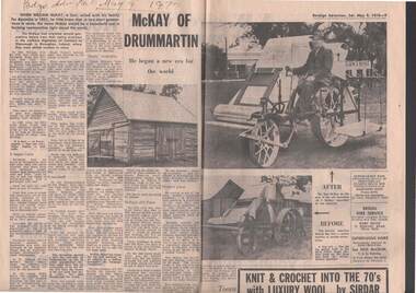 Bendigo Historical Society Inc.
Document - NEWSPAPER ARTICLE MCKAY OF DRUMMARTIN: HUGH VICTOR MCKAY AND FAMILY
Newspaper article (Bendigo Advertiser May 9th, 1970) ''McKay of Drummartin'' - Hugh Victor McKay and family. Family history of McKay family, their farming at Drummartin, the development of the Sunshine Harvester etc. Mention of Pickles firm in Bendigo being one of the contractors used in the early days of production of the harvester (office in Ballarat in 1886). Property in 1970 being in the hands of Ron McKay. Photos of property and early harvester and restoration.Bendigo Advertiserperson, individual, mckay family -
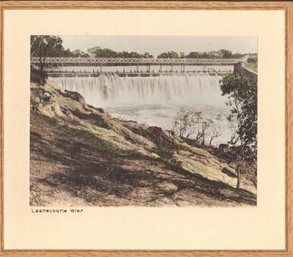 Bendigo Historical Society Inc.
Photograph - LAANECOORIE WEIR
Black and white (hand tinted) photograph of Weir structure at Laanecoorie. Figure on left of photo. Inscriptions: 'Laanecoorie Weir on reverse in black lead pencil. History: James Lerk 17.3.2000 'Laanecoorie Weir' built by Bendigo contractor. Valves by Roberts Foundry ' With note' photographs from Mrs Ella Bourke, 131 Barnard St, Bendigo Ph 43 8269. Photographs Frances (Frank) Thomas Bourke.Francis (Frank) Thomas Kennedyplace, water, laanecorrie weir -
 Bendigo Historical Society Inc.
Document - MCCOLL, RANKIN AND STANISTREET COLLECTION: CENTRAL DEBORAH GOLD MINE NL: WAGES TIME BOOK
Document: McColl, Rankin & Stanistreet Collection: Central Deborah Gold Mine NL - brown cover, spirax No. 578 sketch book. Written on front cover 'Central Deborah Gold Mining Coy. Violet Street, Bendigo.' List of mining contractors and miners with categories 'shifts by others', 'wages shifts by others' 'tons', 'feet', 'expenses', 'remarks'. Written on back cover 'Central Deborah Time Books'.organization, business, central deborah gold mine, mccoll, rankin & stanistreet collection: central deborah gold mine nl, goldmining, wages, contractors, miners, time books -
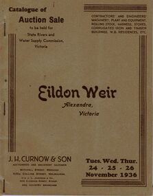 Bendigo Historical Society Inc.
Document - IAN DYETT COLLECTION: AUCTION CATALOGUE - EILDON WEIR
Grey covered auction catalogue with brown printing for a sale on the 24th, 25th and 26th November 1936 for the State Rivers and Water Supply Commission held at Eildon Weir, Alexandra, Victoria. For sale was Contractors' and Engineers' Machinery, Plant and Equipment, Rolling Stock, Harness, Stores, Corrugated Iron and Timber Buildings, W.B. Residences, etc. Contains a black and white photo of the Eildon Weir and the Administrative Quarters, Lot No. 1306.business, auctioneers, j h curnow & son pty ltd, ian dyett collection - auction catalogue - eildon weir, state rivers and water supply commission, j h curnow & son, j l jamieson, bolton bros pty ltd -
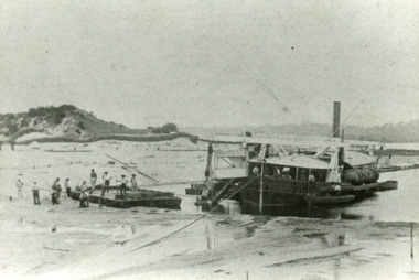 Lakes Entrance Historical Society
Photograph - Wombat, 1885c
The dredge 'Wombat' owned by John Carpenter, contractor for stage one of cutting the entrance from the lake through to ocean - Bass Strait. Photo shows channel partly dredged and men on work platform in front of dredge.Black and white photograph showing bucket dredge Wombat removing sand from between piers. Dunes on western side on left, lakes in background, hills of Kalimna and Nungurner in distance. Work platform in front of dredge with workers. Lakes Entrance Victoria waterways, public works, dredging -
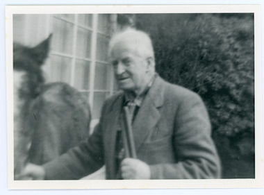 Mt Dandenong & District Historical Society Inc.
Photograph, Edward John Price 1973
John Lundy-Clarke grew up in the Kalorama/Mt Dandenong area and later in life (1972-74) began to write a comprehensive history of the district working from an original settlement map in an effort to cover all areas. Edward John Price (Ted)(1899-1974) was the third child of Edward Joseph and Annie Price. He lived a very industrious life in the area. When the new CRB road cut through the family land Edward John established a Corn and Produce store on a level area adjoining the new road . Along with his brother Charlie, Ted took up road contracting and formed Grange Road in 1923. They also took up contracts to metal the CRB road between The Gap and Olinda. Edward John married Myra Wilson in 1930. They lived in the first brick home built in the district. They had two sons, Edward Joseph 2nd and Alan.Black and white photograph showing an old man dressed in a jacket holding the reins of a horse. Reverse of photograph has handwritten description by John Lundy-Clarke.Edward John Price 1973. Son of Edward Joseph & Annie Ada nee Ross. Born 1899 died 1974. Farmer, Carrier, Sawmiller, Contractor, Quarry Owner, Shop Proprietor (Kew Junction 1935). Father of Alan & Edward J.edward john price, myra wilson, edward joseph price, annie price, alan price, charles price, grange road, crb road -
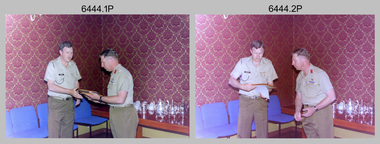 Bendigo Military Museum
Photograph - Commander 3rd Military District Visit – Army Survey Regiment Fortuna, Bendigo, 1989
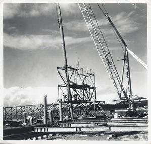
This is a set of 16 photographs of a visit to the Army Survey Regiment, Fortuna, Bendigo by the Commander 3rd Military District BRIG P. Davies AM, ADC on the 23rd and 24th of October 1989. In this set BRIG P. Davies AM, ADC was taken on a tour through the orthophoto production area. In photos .1P to .3P and .6P BRIG P. Davies AM, ADC presented a productivity award to CO LTCOL John Winzar in Fortuna’s Ballroom. LTCOL Winzar was the CO of the Army Survey Regiment from 1987 to 1989. The WILD OR1 orthophoto projector and workstation featuring in photos .7P to.10P and .12P to .14P was introduced in the mid-1980s. It was the second-generation equipment used to orthorectify colour and monochrome film aerial photography, replacing the system introduced in 1973. See items 6124.5P, 6133.4P and 6228.4P for more photographs of orthorectification equipment. Photos .15P and .16P feature contractors preparing the foundations for the construction of Lithographic Squadron’s new Printing Building at Fortuna, Bendigo. The building was purpose built to house a new computer-controlled Heidelberg Speedmaster five colour lithographic offset Printing Press. The print room was named Wayzgoose Hall after a medieval printing house festival. See item 6131.18P for more photographs of contractors preparing the foundations. This is a set of 16 photographs of a visit to the Army Survey Regiment, Fortuna, Bendigo by the Commander 3rd Military District (CMDR 3MD ) BRIG P. Davies AM, ADC on the 23rd and 24th of October 1989. The photographs are on 35mm negative film and were scanned at 96 dpi. They are part of the Army Survey Regiment’s Collection. .1) to .3) - Photo, colour, 1989. L to R: CO LTCOL John Winzar, CMDR 3MD BRIG P. Davies AM, ADC. .4) - Photo, colour, 1989. L to R: SGT Chris Edwards, CMDR 3MD BRIG P. Davies AM, ADC, SGT Graham Johnston, unidentified, SGT Martin Evans. .5) - Photo, colour, 1989. L to R: WO1 Allan Adsett, WO2 Keith Fenton RE UK Exchange, SGT Bob Garritty, WO2 Rob Bogumil, SSGT Peter Imeson, WO1 Ralph Chant. .6) - Photo, colour, 1989. L to R: CO LTCOL John Winzar, WO2 Pat Lumsden, SSGT Di Chalmers. .7) - Photo, colour, 1989. L to R: MAJ Terry Edwards, CMDR 3MD BRIG P. Davies AM, ADC, CPL Graeme Priestley, WO2 Rob Bogumil, SGT Bob Garritty. .8) - Photo, colour, 1989. L to R: CMDR 3MD BRIG P. Davies AM, ADC, CPL Graeme Priestley, SGT Bob Garritty. .9) & .10) - Photo, colour, 1989. L to R: CPL Trevor King, CMDR 3MD BRIG P. Davies AM, ADC, MAJ Terry Edwards. .11) - Photo, colour, 1989. L to R: ADJT CAPT Greg Tolcher, unidentified. .12) - Photo, colour, 1989. CPL Pat Drury, WILD OR-1 Orthorectification Workstation. .13) & .14) - Photo, colour, 1989. CPL Pat Drury, WILD OR-1 Orthorectification Workstation equipment. .15) & .16) - Photo, colour, 1989. Contractors prepare the foundations for Lithographic Squadron’s new Printing Building - Wayzgoose Hall..1P to .16P – no annotations. CMDR 3MD BRIG P. Davies AM, ADC and the date are identified on the film negative sleeve cover sheet.royal australian survey corps, rasvy, army survey regiment, army svy regt, fortuna, asr, litho sqn -
 Kew Historical Society Inc
Plan, Melbourne and Metropolitan Board of Works, Borough of Kew : Detail Plan No.1562, 1905
The Melbourne and Metropolitan Board of Works (MMBW) plans were produced from the 1890s to the 1950s. They were crucial to the design and development of Melbourne's sewerage and drainage system. The plans, at a scale of 40 feet to 1 inch (1:480), provide a detailed historical record of Melbourne streetscapes and environmental features. Each plan covers one or two street blocks (roughly six streets), showing details of buildings, including garden layouts and ownership boundaries, and features such as laneways, drains, bridges, parks, municipal boundaries and other prominent landmarks as they existed at the time each plan was produced. (Source: State Library of Victoria). This plan forms part of a large group of MMBW plans and maps that was donated to the Society by the Mr Poulter, City Engineer of the City of Kew in 1989. Within this collection, thirty-five hand-coloured plans, backed with linen, are of statewide significance as they include annotations that provide details of construction materials used in buildings in the first decade of the 20th century as well as additional information about land ownership and usage. The copies in the Public Record Office Victoria and the State Library of Victoria are monochrome versions which do not denote building materials so that the maps in this collection are invaluable and unique tools for researchers and heritage consultants. A number of the plans are not held in the collection of the State Library of Victoria so they have the additional attribute of rarity.Original survey plan, issued by the MMBW to a contractor with responsibility for constructing sewers in the area identified on the plan within the Borough of Kew. The plan was at some stage hand-coloured, possibly by the contractor, but more likely by officers working in the Engineering Department of the Borough and later Town, then City of Kew. The hand-coloured sections of buildings on the plan were used to denote masonry or brick constructions (pink), weatherboard constructions (yellow), and public buildings (grey). MMBW detail plan No.1562, in contrast to No.1561 includes the names of a large number of houses: in Barkers Road: ‘Ashwick’, ‘Owasso’, ‘Anadiha’, ‘Eurobin’, ‘Carlsruhe’, ‘Arlington’ and ‘Altyre’. Unnamed but clearly represented on the plan is what was then known as the ‘Auburn Heights Recreation Club’, which at this stage included a Bowling Green, a Croquet Green and two Tennis Courts. On the plan, Brougham Place, as it was then known, is represented. It was later renamed Daniell Place. The aforementioned Arlington is now the junior campus of Preshil. melbourne and metropolitan board of works, detail plans, mmbw 1562, cartography -
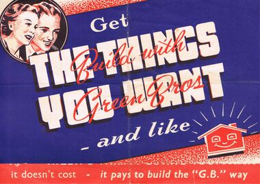 Bendigo Historical Society Inc.
Memorabilia - GREEN BROS BUILDING CONTRACTORS ADVERTISING BROCHURE
BHS CollectionGreen Bros building Contractors Advertising Brochure:-On cream paper background with red, black and blue print, has *Get The Things You Want - and like. Across these words in red ink is *Build with Green Bros* Top left corner in a circle is a man and women's faces smiling down at the words. Bottom right is a caricature of a smiling house. Open the brochure and it tells you about the company *G. B.'Is The Buy Word For All Types of Buildings - Houses, Hall, Garage or Shearers' Hut. See Green Bros Always. Green Bros Building Contractors Epsom, Via Bendigo, Phone 26 Huntly Branch: Henry St Deniliquin, Phone Deniliquin 88. Also is a drawing of a house plan. On the left side is 4 large red dots down the page and caricature of people enjoying themselves. On the Back is Advertising for House Moving Specialists. Bendigo Heavy Haulage Co. Box 625buildings, house, green bros builders., green bros builders. bendigo heavy haulage co. -
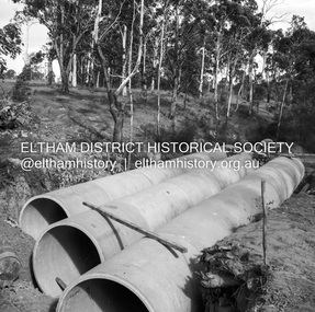 Eltham District Historical Society Inc
Negative - Photograph, J.A. McDonald, Heidelberg-Kinglake Road, Mar. 1960
Cherry Tree Road Job 56F443 Contractors Wolf and Wood Culverts in place, 3 rows 73” diameter 45-degree skew Looking towards Panton Hill – before trimming ends of pipe March 1960Record of various Shire of Eltham infrastructure works undertaken during the period of 1952-1962 involving bridge and road reconstruction projects, sometimes with Eltham Shire Council Project Reference numbers quoted. It was during this period that a number of significant improvements were made to roads and new bridges constructed within the shire that remain in place as of present day (2022). In many situations, the photos provide a tangible visible record of infrastructure that existed throughout the early days of the Shire. The album was put together by or under the direction of the Shire Engineer, J.A. McDonald.infrastructure, 1960-03, bridge construction, cherry tree road, heidelberg-kinglake road, road construction, shire of eltham -
 Hume City Civic Collection
Report Book
Hand written reports on condition of roads and bridges, cost and materials used for repairs, successful contractors named and also reports on tree planting all within the Shire of Bulla. The reports have been written by the Shire Engineer.Green and red covered hard cover book. Spine and corners red with small embossed design. Brown and blue mottled pattern inside front and back covers. Hand written using ink."Shire Hall/Bulla 14th March 1883..."1880s, 1900s, shire of bulla, road construction and maintenance, bridges, bulla, sunbury, george evans collection -
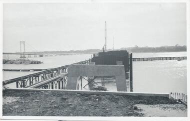
 Phillip Island and District Historical Society Inc.
Photographs, Phillip Island 2nd Bridge Construction, 1966 - 1969
22 of a collection of 70 Black & White photographs taken during the construction of the second Phillip Island Bridge from San Remo to Newhaven by Country Roads Board and Shire of Bass. Contractor John Holland & Co. Pty. Ltd.14 Black & White photographs of the construction of the second Phillip Island Bridge in 1966 - 1969. 351-09: Pile driving on Newhaven abutment. 351-10 & 11: Concrete beams. 351-12: Pile driver. 351-13 & 14: Machinery. 351-15: Dismantled section of cylinder. 351-16 & 17: Coffer dam and pier construction. 351-18: Man up on scaffold. 351-19 & 20: Construction work. 351-21: Two workmen and man leaning on section of handrail exposed to weather. 352-22: View of construction work.Descriptions as above on some. Plus the following Numbering: 351-09: CRB NEG 67-274C. 351-10: CRB NEG 67-542. 351-11: CRB NEG 67-654F. 351-12: CRB NEG 66-605. 351-13: CRB NEG 66-601. 351-14: CRB NEG 68-752B. 351-15: CRB NEG 67-936. 351-16: CRB NEG 67-937A. 351-17: CRB NEG 67-937B. 351-18: CRB NEG 67-1156D. 351-19: CRB NEG 67-1156B. 351-20: CRB NEG 66-1026E. 351-21: CRB NEG 67-940. 351-22: CRB NEG 67-1218Bphillip island bridge construction, 2nd phillip island bridge construction, country roads board, shire of bass, sasha stark -
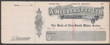 Bendigo Historical Society Inc.
Document - CAMBRIDGE PRESS COLLECTION: CHEQUE - A. MEURERS
Cheque with cheque butt attached and date line ending 192-. A. Meurers Pty. Ltd. Bendigo. Hardware Merchants. Sewerage Contractors printed at the top of cheque. Decorative background and an illustration of Meurers Patented Hygienic Glass Washer. The Bank of New South Wales, Bendigo printed in the centre. Decorative work along the left edge with Cambridge Press Print beside it. Printed in grey and black with red Not Negotiable across the centre.business, printers, cambridge press, cambridge press collection, a meurers pty ltd, the bank of new south wales bendigo, cambridge press, meurers patented hygenic glass washer -
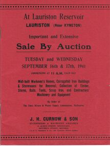 Bendigo Historical Society Inc.
Document - MCCOLL, RANKIN AND STANISTREET COLLECTION: LAURISTON RESERVOIR AUCTION, September 16th/17th 1941
Catalogue of Sale By Auction of buildings, timber, stores, rails, tools, scrap iron, and contractors machinery and equipment. Auction to be held Tuesday and Wednesday September 16th and 17th , 1941. By order of the State Rivers and Water Supply Commission, Melbourne. J. H. Curnow & Son, Auctioneers & Machinery Salesmen, 31 Queen Street, Melbourne 3000 and Mitchell Street Bendigo Victoria 3550. To be held at Lauriston reservoir, Lauriston (near Kyneton).J.H. Curnow & Son, 31 Queen Street Melbourne.government, state, lauriston reservoir -
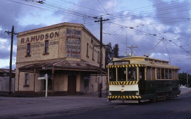 Ballarat Tramway Museum
Slide - Tram 28 Victoria and Humfray Streets, Richard Jones, Dec. 1969
Image shows Ballarat 28 descending the hill in Victoria St crossing over Humffray St with R A Hudson Electrical Contractor and Plumbers building in the background. A former hotel. The tram has the destination of Gardens via Sturt St West.Yields information about the corner of Humffray and Victoria Streets Dec. 1969Digital image of a Kodachrome slideballarat, trams, tramways, tram 28, victoria st, humffray st -
 Uniting Church Archives - Synod of Victoria
Photograph, undated
The first church building on this site faced Erica St. The "new" church was built in 1929 facing Balwyn Road. The new church was built in memory of Sir Aaron Danks. The Architect was Mr Louis R. Williams, the building contractor was Mr A. Richardson.Sepia photograph in postcard format of the Balwyn Road Methodist Church, Canterbury. The photograph shows two church buildings and part of a hall behind a picket fence.balwyn road methodst, canterbury, erica street, sir aaron danks, mr louis r. williams, mr a. richardson -
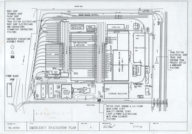 Melbourne Tram Museum
Document - Preston Workshops, Public Transport Corporation (PTC), Emergency Evacuation Plan", Oct. 1994
Plan dated 3/10/1994 shows the layout of the Preston Workshops tracks, buildings at the time and emergency evacuation assembly points. At the time operated by the Public Transport Corporation with ABB Contractors and Goninan Tram Project Offices. Document Number T01_447501.Yields information about the layout of Preston Workshops in 1994.Photocopy of an A4 plan or document.tramways, trams, preston workshops, floor plans, track plans -
 Kew Historical Society Inc
Plan, Melbourne and Metropolitan Board of Works, Borough of Kew : Detail Plan No.1580, 1904
The Melbourne and Metropolitan Board of Works (MMBW) plans were produced from the 1890s to the 1950s. They were crucial to the design and development of Melbourne's sewerage and drainage system. The plans, at a scale of 40 feet to 1 inch (1:480), provide a detailed historical record of Melbourne streetscapes and environmental features. Each plan covers one or two street blocks (roughly six streets), showing details of buildings, including garden layouts and ownership boundaries, and features such as laneways, drains, bridges, parks, municipal boundaries and other prominent landmarks as they existed at the time each plan was produced. (Source: State Library of Victoria)This plan forms part of a large group of MMBW plans and maps that was donated to the Society by the Mr Poulter, City Engineer of the City of Kew in 1989. Within this collection, thirty-five hand-coloured plans, backed with linen, are of statewide significance as they include annotations that provide details of construction materials used in buildings in the first decade of the 20th century as well as additional information about land ownership and usage. The copies in the Public Record Office Victoria and the State Library of Victoria are monochrome versions which do not denote building materials so that the maps in this collection are invaluable and unique tools for researchers and heritage consultants. A number of the plans are not held in the collection of the State Library of Victoria so they have the additional attribute of rarity.Original survey plan, issued by the MMBW to a contractor with responsibility for constructing sewers in the area identified on the plan within the Borough of Kew. The plan was at some stage hand-coloured, possibly by the contractor, but more likely by officers working in the Engineering Department of the Borough and later Town, then City of Kew. The hand-coloured sections of buildings on the plan were used to denote masonry or brick constructions (pink), weatherboard constructions (yellow), and public buildings (grey). The area represented in this detail plan has undergone significant change during the 20th century. The widening of High Street in the 1930s and 1950s involved the shops on the south side of High Street being demolished and later rebuilt to fit the widened street. Another significant loss was the mansion ‘Drayton’ fronting Wellington Street, owned at this stage by Susannah Fenton. Her family name would later to be given to Fenton Way, which was to be built over the grounds of the house following its demolition. The plan of the garden is particularly interesting, containing a batten dome fronting Wellington Street, an ornamental pond, a fountain and a brick and glass conservatory. The notes by the plumbing contractor on this plan are particularly detailed. Pink borders delineate the ownership of the varying parcels of land. Some of the better known owners listed include the real estate agent Cr. Henry de Castres Kellett (bt) and John Padbury, the funeral director. This particular plan provides a clear view of the configuration of the Kew Junction in 1903 and the commercial buildings that surrounded it.melbourne and metropolitan board of works, detail plans, maps - borough of kew, mmbw 1580, cartography -
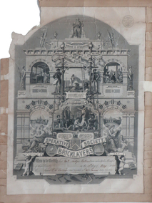 Federation University Historical Collection
Certificate, Operative Society Bricklayers, 18/05/1888
The Operative Bricklayers' Society (OBS) was a British New Model Trade Union based in London. In 1888 there were 50 members of the Ballarat Bricklayers' Society. There were 100 bricklayers labourers. (Ballarat Star, 10 August 1888) "THE BRICKLAYERS' STRIKE AT BALLARAT From Our Correspondent. BALLARAT, Saturday. It is understood that the bricklayers' strike will terminate shortly. One leading contractor has intimated his intention of complying with union rules, and already he has put society men on to work under the 45 hours' system. Other contractors will, it is expected, do likewise next week, and then building operations will again be in full swing. (Age, 10 September 1888)Printed illustrated certificate on paper for the Operative Society Bricklayers No 3 Ballarat LodgeThis is to certify that No 3 Lodge Ballarat was admitted a Member of this Society on the 17th day of May 1888 Signed [H.A. Ballows ?] Genl Secretary {J ? ] James Lodge Secretaryj h james, certificate, r h bullows, operative society bricklayers, j h le keux, unions, bricklaying, r.h. ballows, ballarat branch