Showing 266 items
matching early residences
-
 Melbourne Legacy
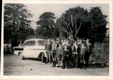
Photograph, Blamey House, 196
A photo of children by a car outside Blamey House in the early 1960s. Names are not known.A record of the residence in Burke Road named Blamey House.Black and white photo of children on near a car at Blamey House.residences, blamey house -
 Melbourne Legacy
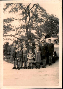
Photograph, Blamey House, 196
A photo of children by a car outside Blamey House in the early 1960s. Names are not known.A record of the residence in Burke Road named Blamey House.Black and white photo of children near a car at Blamey House.residences, blamey house -
 Parks Victoria - Cape Nelson Lightstation
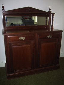
Furniture - Sideboard
The cedar sideboard has two cupboard doors below two corresponding drawers. The style is in keeping with the completion date of the lightstation in 1884, when furniture in the late nineteenth century had squarer, more defined lines and angles, and ornamental features. This sideboard is a modest version of this trend combining a pediment‐shaped back board with turned side columns and finials, rectangular mirror, decorative drawer pulls and door handle, as well as cupboards and drawers with bevelled, raised panels. The initials ‘PWD’along with a crown motif and letters are inscribed on the side indicating that the furnishing was the property of the government and made in its workshops. The Public Works Department, which operated in Victoria from 1855 to 1987, was responsible for the design of Victoria’s major public buildings and provision of furnishings to its offices as well as residences where the need was required.301 The keepers’ quarters at Cape Otway Lightstation were supplied with two of the same sideboards, which remain there today; on is intact (COLS 0001), the other missing the backboard (COLS 0015). Two similar but plainer examples, which are probably earlier in date, also remain at Cape Schanck (CSLS 0007.3; CSLS 0009.3). The Cape Nelson sideboard has first level contributory significance as a fine example of the good quality domestic furnishings made by the Victorian Government and provided to lighthouse keepers and their families in the late nineteenth century. It is also significant for its provenance to the lightstationThe cedar sideboard has two cupboard doors below two corresponding drawers with pediments‐shaped back board with turned side columns and finials, a rectangular mirror, decorative drawer pulls and door handle, as well as cupboards and drawers with bevelled, raised panels. -
 Melton City Libraries
Photograph, High Street, Melton, c.1970
The shops pictured in the photographs include Andrews Real Estate–site of early bank, Riddell, Ross house “Iona”, Shelley Saddlery and Residence, Simpsons Butcher Shop, Backhouse Butcher, Carew and Miss Raleighs Shop. House of Parker, and K Masterson. Shops on the north side of High Street, Meltonlandscapes of significance -
 Melton City Libraries
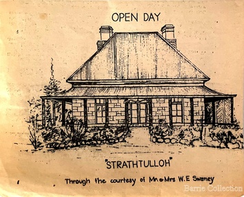
Drawing, Open Day at Strathtulloh, Unknown
"Strathtulloh, 1402-1600 Greigs Road, Melton South, is significant as an early property in Victoria, retaining different eras of pioneering dwellings, ranging from a ruin to a fine Colonial style homestead. The property has close historical association with the early settlement of the Melton district, and was owned by the Henty family in the 1840s. The Strathtulloh property was alienated by the Crown in 1840 to Charles James Garrard, who sold it in 1848 to Charles and Stephen Henty, whose sister Jane and her husband Samuel Bryan lived there in the late 1840s. In 1853 the property then passed to William Tulloh, after whom the homestead was named. A primitive bluestone ruin of near the Toolern Creek, built of vesicular bluestone and mud mortar, is of unknown origin. It has commonly been assumed to pre-date 1840, and to have belonged to the original holder of the Exford lease, Dr Watton or Port Phillip Association member Dr Cotterill. This is unlikely, as the 1841 census records Dr Watton, and everyone else in the district, as living in a ‘wood’ dwelling. It may instead have been the residence of Garrard, and the Bryans, in the 1840s and an early map names a site near here as ‘Bryan’s outstation’. It is assumed that the two-level stone building that became the kitchen is the earliest intact building on the site, and was the first homestead; it is likely to date to the 1840s or 1850s. The main homestead is a substantial villa constructed of random coursed bluestone, with a verandah facing three sides, attic bedrooms with dormer windows, a fan light over the front door, a hipped roof originally clad in slate, and a large cellar. Although demonstrating characteristics of pioneering construction, such as unworked log beams, pit sawn beams, hand-sawn lintels and colonial door locks, documentary evidence shows that it was built c.1869. The homestead has now been structurally repaired and decoratively restored; a sympathetic new semi-detached rear extension was added in the early years of the 21st century. The former kitchen building has also undergone minor repairs and alterations". Strathtulloh Homestead at 1402-1600 Greigs Road, Melton Southlocal architecture -
 Melton City Libraries
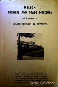
Booklet, Melton Business and Trade Directory, c.1965
BUSINESS TRADE AND DIRECTORY MAP NORTH of High Street RALIEGHS Road - Early settlers Oliver Reierson ( Norwegian) Raliegh SHEBLER Court Auguste EMIL Court Jongebloed Family residence “Hemlich” ALEXANDRA Street Coronation King, Queen Alexandra - 1903 O’NEILS Road Farmer OLDERSHAW Road CORR Grove Early landowner, Teacher at the Common School – Denominational Churches, 1850’s Wesleyan (Methodist) BRYAN Court 1850’s resident renamed from earliest town site - Flat HURLEY Street Early settler and farmers - CHESNEY Road was named Minns, due to duplication altered to Chesney (Minns) SOUTH of High ALKEMADE Drive. Family name ARNOLD Court Family BARRIES Road Charles Ernest Barrie “Darlingsford” 1911 Residence KILPATRICKS Road became Barries Road west of Station Road BLACKWOOD Drive Alexander, Early settler CALLANAN Drive Surveyor early LUBY Court John Luby - Crown Grant Land title KERWIN Street Michael - Crown Grant land title (deleted due to Freeway)Pamphlet of Melton Businesses and map of the townlocal identities, misc., council -
 Melton City Libraries
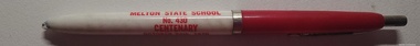
Memorabilia, Melton State School Centenary, 1970
On 17th May 1858 a State subsidised, combined Denominational School was opened by HT Stokes, with an attendance of about 30 children. This school was conducted in the wooden Melton Combined Protestant Church, situated on ‘a creek flat’ thought to be on the north side of Sherwin Street between Pyke and Byran Streets. It is likely that the Church had been established by 1855 and that the first minister was the Rev. Hampshire, who lived in Cambridge House on the Exford Estate. Ministers of the Protestant denominations were invited to hold services there. As there was only one resident Minister in the town (Presbyterian Mr J Lambie), laymen of the various denominations often spoke on Sundays. In 1863 this building was declared a Common School with the number 430. One of its first and most prominent headmasters was John Corr, who served from 1860 to 1864. Most of Mr Corr’s children also became teachers, including Joseph Corr, at the Rockbank school, and J Reford Corr and WS Corr, headmasters and teachers at numerous prestigious private secondary schools around Australia. John Corr purchased land alongside the school and elsewhere in and near Melton, became secretary and treasurer of the new Cemetery Trust, and by July 1861 was deputy registrar of births, deaths and marriages. He walked three miles every Sunday to teach at the Weslyan Sunday School he had established. Despite good reports from the Education Department Inspector, and burgeoning enrolments, the local school committee recommended the dismissal of, firstly, his wife (from the work mistress position), and then him from the headmaster position. Corr saw his dismissal as an attempt to redirect state aid for education from the Combined Protestant school to the support of the Free Presbyterian Minister Rev James Lambie (by one account the owner of the land on which the Common School was erected), whose son-in-law James Scott subsequently assumed responsibility for the school. Rev Lambie failed in his efforts to keep the existing school, which the Education Department Inspector and the majority of Melton citizens regarded as badly situated and badly built. Following a conditional promise of state aid, local contributors in 1868-69 raised ₤72.10.6 towards the cost of an iron-roofed bluestone rubble building 43 ft x 12 ft. This was erected on a new site of 1.5 acres (the present site). The State contributed ₤120 to the new school, which opened in 1870. A very early (c.1874) photograph of the school shows its headmaster and work mistress / assistant teacher (probably James Scott and his wife Jessie) and its (very young) scholars. Similar photos show pupils in front of the school in c.1903, and 1933. In 1877 a second bluestone room costing ₤297 was added and further land acquired from the Agricultural Society (who only needed it two days a year) to enlarge the schoolground to 3 acres. In the early 1880s an underground tank augmented the school water supply and in 1919 a five-roomed wooden residence was added. During this period the school correspondents often compained that the walls of the bluestone buildings were damp, affecting the plaster. In 1923 a brick room 26 ft 6 in by 24 ft with a fireplace and four rooms facing south, was added, and a corridor built to link the three buildings. This served adequately for the next 40 years. The school bell probably dates to 1883. The school also has a memorial gate (1951) to World War One ex-students, and an honour board to the 64 ex-students who served in the First World War. The school roll fell to 42 in the early post war-years, but was boosted by an influx of migrants, mainly from the UK, from the late 1960s. This presaged the boom in Melton’s development, and the corresponding growth of the school, with timber and temporary classrooms added to the previous masonry ones. An endowment pine plantation established in 1930 augmented the school’s fundraising activities when it was harvested in 1968. Part of the site was planted with eucalyptus trees in 1959. Famous ex-students of the early twentieth century included Hector Fraser (internationally successful shooter) and cyclist Sir Hubert Opperman. Pen, flag and flyer from the Melton State School Centenary celebrationseducation, local significant events -
 Melton City Libraries
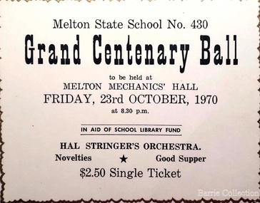
Document, Grand Centenary Ball Ticket, 1970
History of the Place "On 17th May 1858 a State subsidised, combined Denominational School was opened by HT Stokes, with an attendance of about 30 children. This school was conducted in the wooden Melton Combined Protestant Church, situated on ‘a creek flat’ thought to be on the north side of Sherwin Street between Pyke and Byran Streets. It is likely that the Church had been established by 1855 and that the first minister was the Rev. Hampshire, who lived in Cambridge House on the Exford Estate. Ministers of the Protestant denominations were invited to hold services there. As there was only one resident Minister in the town (Presbyterian Mr J Lambie), laymen of the various denominations often spoke on Sundays. In 1863 this building was declared a Common School with the number 430. One of its first and most prominent headmasters was John Corr, who served from 1860 to 1864. Most of Mr Corr’s children also became teachers, including Joseph Corr, at the Rockbank school, and J Reford Corr and WS Corr, headmasters and teachers at numerous prestigious private secondary schools around Australia. John Corr purchased land alongside the school and elsewhere in and near Melton, became secretary and treasurer of the new Cemetery Trust, and by July 1861 was deputy registrar of births, deaths and marriages. He walked three miles every Sunday to teach at the Weslyan Sunday School he had established. Despite good reports from the Education Department Inspector, and burgeoning enrolments, the local school committee recommended the dismissal of, firstly, his wife (from the work mistress position), and then him from the headmaster position. Corr saw his dismissal as an attempt to redirect state aid for education from the Combined Protestant school to the support of the Free Presbyterian Minister Rev James Lambie (by one account the owner of the land on which the Common School was erected), whose son-in-law James Scott subsequently assumed responsibility for the school. Rev Lambie failed in his efforts to keep the existing school, which the Education Department Inspector and the majority of Melton citizens regarded as badly situated and badly built. Following a conditional promise of state aid, local contributors in 1868-69 raised ₤72.10.6 towards the cost of an iron-roofed bluestone rubble building 43 ft x 12 ft. This was erected on a new site of 1.5 acres (the present site). The State contributed ₤120 to the new school, which opened in 1870. A very early (c.1874) photograph of the school shows its headmaster and work mistress / assistant teacher (probably James Scott and his wife Jessie) and its (very young) scholars. Similar photos show pupils in front of the school in c.1903, and 1933. In 1877 a second bluestone room costing ₤297 was added and further land acquired from the Agricultural Society (who only needed it two days a year) to enlarge the schoolground to 3 acres. In the early 1880s an underground tank augmented the school water supply and in 1919 a five-roomed wooden residence was added. During this period the school correspondents often compained that the walls of the bluestone buildings were damp, affecting the plaster. In 1923 a brick room 26 ft 6 in by 24 ft with a fireplace and four rooms facing south, was added, and a corridor built to link the three buildings. This served adequately for the next 40 years. The school bell probably dates to 1883. The school also has a memorial gate (1951) to World War One ex-students, and an honour board to the 64 ex-students who served in the First World War. The school roll fell to 42 in the early post war-years, but was boosted by an influx of migrants, mainly from the UK, from the late 1960s. This presaged the boom in Melton’s development, and the corresponding growth of the school, with timber and temporary classrooms added to the previous masonry ones. An endowment pine plantation established in 1930 augmented the school’s fundraising activities when it was harvested in 1968. Part of the site was planted with eucalyptus trees in 1959. Famous ex-students of the early twentieth century included Hector Fraser (internationally successful shooter) and cyclist Sir Hubert Opperman". Ticket for the Grand Centenary Ball at Melton State School 430education, local significant events -
 Melton City Libraries
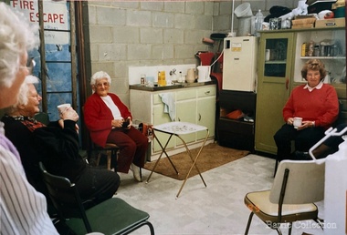
Photograph, Melton Uniting Church Opportunity Shop volunteers, 1993
In the early l 970's , when our population was increasing rapidly and resident ministers were needed at both Melton and Bacchus Marsh, and after discussion between both denominations over many months a decision was reached , that in both areas they would unite and be known as Methodist - Presbyterian joint parishes. In 1972 Ministers were appointed, and Melton's minister occupied one of the Bacchus Marsh Manses during the building of Melton's church residence in Y uille Street. Services were held at Scots Presbyterian Church Melton. Youth Club and church meetings were held in the Methodist Church at Brooklyn Road, Melton South. At a joint Parish Committee Meeting held in May 1975 at Melton South - a major item of business was finance, to meet the repayments on the recently built Church Manse and the minister's Stipend. The meeting closed without any solution to this problem being made. As the men restacked the chairs Maisie and I viewed the building with the possibility of opening an Opp Shop on the premises. We then made the suggestion to the other members and during the forthcoming weeks investigations concerning the feasibility of this idea were made, volunteers recruited and the shop opened in July 1975. The first contribution to the Church funds of $1,600 was made in 1976 and was followed by regular contributions to the church budget each year. In 1981 a 30'x 20' steel garage costing $2,000 was erected adjacent to the original Methodist Church to provide more space. Meanwhile an Opp Shop was opened in Melton Markets and operated from 1981 to 1985. Further accommodation was needed at Yuille Street and the Atco Hall was installed at the rear of the Bluestone Church (known as Melton Uniting Church - 1977). A large proportion of finance for this project was contributed by the Opp Shop $16,000. Simultaneously finance was being built up to provide further facilities at Brooklyn Rd, resulting in the commencement of a concrete block masonry and steel extension, with facilities & fittings, being commenced during 1986 & completed in 1989. The approximate total cost of this structure was $60,000. Over the 16 years, members and friends of our church have contributed many many hours to staff the shop and many other supportive works. As an acknowledgement of their efforts, our Minister prepared Certificates for Service and Dedication which were presented to 75 supporters at a special Church Service in June 1991. The assistance that has been given to the community of Melton & District has been extensive and much appreciated by many families. In addition many appeals for goods and clothing have been received and packages sent to many outside supportive agencies. Three volunteers having a tea break in the staffroom of the Op Shoplocal identities, churches -
 Melton City Libraries
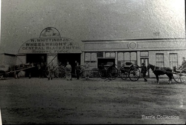
Photograph, W.Whittington Wheelwright, Unknown
Blacksmith Shop High Street Melton Residence and Blacksmith Shop was continuously occupied from 1860 and demolished in 1966. Mr A.G. Macdonald operated the shop from 1923-1962 (39 years) An early photo exists of the Blacksmith Shop. It stood on what is now part of the landscaped area of the Melton Community Hall. The three blacksmiths wearing aprons are from the left, W. Whittington, G. Macdonald and A Falconer. MacDonald were employed by Whittington prior to each one in turn taking over the business, Falconer soon after selling the to MacDonald, died. He is buried in the Melton Cemetery. The old Smithy [on the right] stood in what is now 8 High Street Melton. The blacksmith and wheelwright was the forerunner of the modern motor mechanic, whose task it was and is, to keep the wheels of locomotion turning. According to the records there was a Blacksmith in Melton before 1850. In 1871, three blacksmiths, Messrs. A Blackwood, J MacPherson, and A Cameron were operating in Melton. In 1872 Mr. J.B. Whittington commenced as a blacksmith in Toolern Vale. On January 30th 1900, Mr Alexander Blackwood sold the property shown in the picture to J.B. Whittington where his son William Whittington conducted the business. William’s three children attended Melton State School No 340 The family left the district in 1921 when they moved to Essendon. Mr William Whittington died in 1963 at the age of 94. The next owner of the business, for a short period, was Mr. Ackland Falconer, who was succeeded by Mr A.G. Gordon MacDonald, in September 1923. Mr MacDonald raised a family of three. Thirty nine years later, in 1962, he retired, going to live with his son Robert in Sunshine, and the blacksmith shop finally closed its doors. This part of Melton’s history was demolished in by order of the Housing Commission, in 1966. Article research by Melton and District Historical Society Members. note: spelling should be Macdonald. History of the Melton Mechanics Institute. Mabel Rogers 1985 A.G. Macdonald Secretary 1927 – 1956 page 17. Committee member for 41 years. He also held the position of caretaker Blacksmith Shop, High Street Melton. The three blacksmiths wearing aprons are from the left, W. Whittington, G. Macdonald and A Falconer. local identities -
 Harcourt Valley Heritage & Tourist Centre
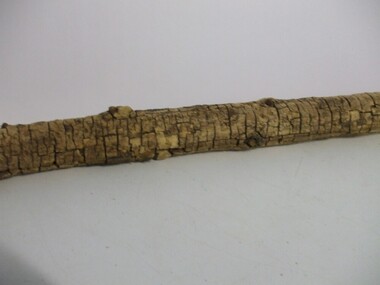
Mulberry Tree Branch, 1874
An unsuccessful attempt was made to set up a silkworm industry at Mt Alexander, to be an occupation for ladies of the district as well as to introduce the silk industry to Victoria. An attempt by women to enter the business world was beaten by difficulties: (1). Road access to the property (2). Heavy frost damage to mulberry plants. (3). Disease of silkworms. (4). Lack of quantity of leaves. (5) drought and rabbits. Experiments proved silk harvested and woven was superior to overseas products, but the venture was defeated by the climate and the surviving trees were relocated to Corowa NSWA relic of the far-sighted venture by the Victorian Ladies Sericulture Co, promoted by the charismatic Mrs Bladen Neill , who was anxious to generate employment opportunities for women..A dead branch from a mulberry tree grown at Sericulture Farm, Mt Alexander, in the early 1870s. This long limb's bark has cracked with age, forming a pattern of brown cracks. Remnants of smaller branch axilla are clearly visible. An inscription on paper is pasted around the branchTyped: "Part of a limb of a mulberry tree from the Sericulture Farm on Mt Alexander which was started by Mrs Bladen-Neill in early 1870s, finally closing in 1878. Mrs Bladen-Neill died in September 1884 at the residence of Dr Barker, Melbourne" "Courtesy of Keith Henderson, Harcourt" -
 Wodonga & District Historical Society Inc
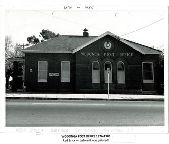
Photograph - Codling Collection 01 - Wodonga Post Office
Miss Olive Codling was a Foundation Member and a Life Member of the Wodonga Historical Society. Many of her photos are held in the Society Collection. The Wodonga Post Office was constructed on the corner of Sydney Road (High Street) and South Street in 1874. It was Wodonga’s second Post Office. The original post office opened on June 1, 1856 near Wodonga Creek. This building was originally built of red brick, although it was later painted over in white. It had an attached residence in South Street and was connected to it by a door. The residence was later demolished to move the mail boxes which had faced High Street, to South Street. The brick Telephone Exchange was constructed in 1946 behind the Post Office but separated from it. It operated as a manual exchange until the late 1960’s or early 1970’s. In 1985 a new post office was opened further south in High Street. This building, greatly renovated, is now part of the Wodonga Community College.This photo collection is significant as it documents how the businesses and buildings in Wodonga have evolved and contributed to community throughout the 20th century. A black and white image of the 2nd Wodonga Post Office. There are 6 windows across the front of the building and the name Wodonga Post Office below a round clock. To the left of the building is the royal insignia of the crown above the letters E.R. A sign for the Commonwealth Saving Bank of Australia is also attached to the wall.high st wodonga, wodonga post office, businesses wodonga -
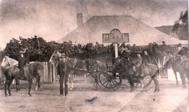 Wodonga & District Historical Society Inc
Photograph - Mac's Hotel, Wodonga, c1870s
“Mac's Hotel" in Wodonga West, one of Wodonga's earliest hotels, was owned by William Christie McFarlane who arrived in Melbourne in December 1854 from Stirling, Scotland. He spent his first three years mining for gold at Beechworth. For the next three years he was the manager of the King’s Hotel at Wooragee, which was owned by his father-in-law, Charles David King. In 1860 he bought 180 acres of land at Wodonga, eventually extending his holdings to 1,000 acres on which he farmed. He called his property “Abbey Craig” after his home in Scotland. In time he owned several properties in Wodonga, a small vineyard and 'Mac's Hotel'. Mac’s Hotel was a popular meeting place for teamsters and other travellers on the Sydney Road. It opened in the early 1860s and the license was at times in the name of W. C. McFarlane and at other times held by his wife, Mary McFarlane. William had several positions during his life in Wodonga including serving as Postmaster and conducting a Commission and Insurance Agency business. He was appointed Secretary to the first Wodonga Building Society. W. C. McFarlane also filled the position of Sheriff’s Officer, Registrar of Births and Deaths and Marriages, and Justice of the Peace. W. C. McFarlane served as a member of the Wodonga Shire Council for several years including three terms as Shire President: 1889-90, 1890-1891 and 1894-95. He passed away in Wodonga in December 1906. After his death, the license of Mac’s Hotel continued to be held by Mary McFarlane until her death in November 1910. The license was not renewed and the hotel was taken over as a residence by their son, Walter McFarlane. Unfortunately, on 25 January 1913, Walter was assisting neighbours fighting grass fires about 3 miles away when his own home was completely destroyed by fire, bringing to an end the long history of the popular hostelry, Mac’s Hotel.This image is significant because it documents an early business in Wodonga conducted by a prominent Wodonga resident.Black and white image of people standing, on horseback and in coach outside Mac' Hotel, West Wodongamac's hotel, hotels wodonga -
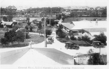 Lakes Entrance Historical Society
Postcard, 1928c
Black and white photograph of Whiters Park, showing residence and office, gardens, tennis court, early model car by the petrol bowser, electric lights on tall poles. Opposite park entry is Aults Motor Engineer, scattered cottages. In distance is Cunninghame Arm, sand hummocks and ocean. Lakes Entrance Victoriaresort, township, transport, recreation -
![Map, Plan of Town Allotments Bacchus Marsh [1873]](/media/collectors/5e461d8021ea67224c82f2a1/items/677a8ee7ab7bb47995c5573f/item-media/677a8fdeab7bb47995c55b56/item-fit-380x285.jpg) Bacchus Marsh & District Historical Society
Bacchus Marsh & District Historical SocietyMap, Plan of Town Allotments Bacchus Marsh [1873]
James Young was a prominent businessman, land owner and public figure in the early colonial period of Bacchus Marsh. After his death in 1871 land remaining from his estate in Bacchus Marsh was sold at auction in 1873. The sale of his estate included the substantial stone residence in Bennett Street which later became known as 'Stone Villa'. The sale of his land in 1873 was conducted by local auctioneer James Crook. 29 allotments were advertised for sale, although the plan for the sale indicated 30 allotments. The sale notice in the Bacchus Marsh Express of 11 October 1873 noted that the allotments were " in the very centre and heart of the most populous and business portion of the township, at the same time being the only remaining portion of the business block available for purchase by public sale, which fact intending purchasers should not lose sight of, as the opportunity cannot occur again". The designation of a new street, 'Bennett Street', shown on the plan, is also indicated in the advertising, "In reference to the main street frontages, opposite the Border Flour Mills. The Auctioneer would also direct attention to the plan, showing the formation of a new thorough fare (Bennett street) leading from Young street into Gell street, thus opening up the township on the high, more healthy, and commanding position so much to be desired for private dwellings".An important cartographic document which indicates an early major subdivision of land in the inner urban area of the Bacchus Marsh township. This subdivision lead to the continuing residential and commercial development of the township of Bacchus Marsh in the later part of the 19th century. The location of two well known demolished public structures, the Free Gardeners Hall in Gell Street, and the Old Mechanics Institute Hall (aka the Buffs Hall), on the corner of Young and Bennett Streets, are also shown on this map.A single page paper map showing 30 blocks of land for sale around 1873 in the vicinity of Bennett Street and Lerderderg Street. Described in contemorary sources as a 'lithographed copy'. No scale is indicated. The map is pasted into a bound volume containing 76 maps or plans in total. High resolution digital image stored on BMDHS computer network. land sales bacchus marsh, bacchus marsh victoria maps, james young 1816-1871, bacchus marsh roads and streets, bennett street bacchus marsh -
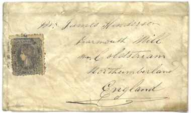 Bacchus Marsh & District Historical Society
Document, Envelope used for letter to Mr James Henderson, Learmouth Mill, Coldstream, Northumberland, England. 1861
This envelope was used to post a letter or other similar document from Bacchus Marsh in Victoria around November 1861 to a Mr James Henderson in Coldstream, Northumberland, England. The contents inside the envelope have been lost and the sender of the envelope is not known. Postal services in Bacchus Marsh can be traced back to at least 1847 when Henry James of Bacchus Marsh was appointed postmaster for Bacchus Marsh replacing the service previously conducted from Ballan. Henry James conducted this postal service from his residence. This service was still designated as the Ballan Post Office until September 1850 when its name was formally changed to the Bacchus Marsh Post Office. The envelope of 1861 addressed to Mr Henderson in England is therefore a fairly early documentary artifact from users of the Bacchus Marsh postal service. An envelope used for a letter in 1861. An address in Norththumberland, England is written on the front of the envelope. It also shows a postage stamp depicting Queen Victoria of Great Britain. The postage stamp is a sixpence stamp produced in the colony of Victoria in the 1850s and 1860s. On the reverse of the envelope are 3 circular shaped post office marks: 'Bacchus Marsh Victoria No.25 1861'; 'Melbourne 1 Z No.25 61'; and 'Coldstream JA22 62'.envelopes, postal services, bacchus marsh post office -
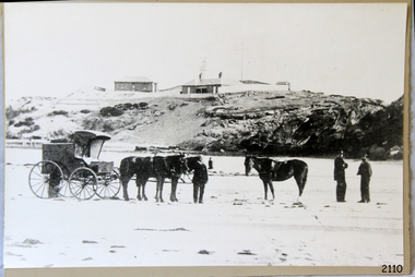 Flagstaff Hill Maritime Museum and Village
Photograph - Scene - Warrnambool, C. 1854-1871
This is an image of the Warrnambool Lighthouse Complex on Middle Island in 1854. The Store, Lighthouse Keeper's Quarters, Lighthouse and Flagstaff are in the background. The foreground shows a covered buggy drawn by two horses and a person in attendance, and another wheeled vehicle behind it with a figure nearby. There is a saddled horse to the right with two males in conversation nearby. The ground is soft, perhaps the riverbed or sandy shore. THE LIGHTHOUSE KEEPERS Lighthouse Keepers were responsible for keeping their Lighthouse’s lights shining at night. They kept a lookout for passing vessels and changes in weather. They were expected to clean, polish and maintain the equipment and buildings. They kept regular and detailed records of who was on watch, and the time the light was lit, trimmed and extinguished. They kept a journal about other events that occurred. They keep regular, accurate Meteorological Logs. It was expected that they were competent in Morse code signalling. They would be called to help in times of disasters and shipwrecks and to give official statements about these events. Many Lighthouse Keepers also volunteered as members of the lifeboat crew. The Lady Bay lighthouses were officially classified as small, so the Keepers had the official titles of Senior Assistant Lighthouse Keeper and Assistant Lighthouse Keeper. They were employed by the Public Service and paid rent to live in the Lighthouse Quarters. They were compulsorily retired at the age of 60, with most receiving a superannuation payment. Despite their time-consuming duties, there was time to follow hobbies and crafts such as growing vegetables, playing musical instruments, making models of buildings including lighthouses, and crafting furniture pieces. An example of a keeper’s skills is the carved fire screen made by /assistant Keeper Thomas Hope in the late 19th century and displayed in the Lighthouse Keeper’s cottage at Flagstaff Hill. Both Alexander and Farncombe had served under Senior Keeper Robert Deverell, who was the first and only Senior Lighthouse Keeper at the Middle Island Complex. John Alexander was the Assistant Keeper in the 1850s. Andrew Farncombe was the last Assistant Keeper at Middle Island, serving there with his family from 1864 to 1871. During 1871 and 1872 the Lighthouse Complex was moved to Flagstaff Hill on Merri Street. Farncombe and Deverell then became the first Keepers and occupants of the Lady Bay Lighthouse Complex at Flagstaff Hill. They continued their service together; overall, Deverell served from 1859 to 1885 and Farncombe from 1864 to 1974. WARRNAMBOOL'S LADY BAY LIGHTHOUSE COMPLEX - The original Lighthouse Complex was built on Middle Island in 1858-1859 then transferred stone-by-stone to Flagstaff Hill in 1871. The Complex comprised the Lighthouse, the Lighthouse Keepers’ Quarters and a Privy. The bluestone Keeper’s Quarters was a cottage divided into two compartments, one for the Senior Keeper and his family, the other for the Assistant Keeper and his family. The bluestone Store was divided into three; a store, a workshop, and an oil store (or office). The Privy comprised a small building also divided into two separate, back-to-back toilets, one for each Keeper and his family. In the 1970s the Flagstaff Hill Planning Board was set up under the chairmanship of John Lindsay. The Board was to make recommendations to the Warrnambool City Council regarding the use of the buildings and the rest of the Crown Land on the site. The Flagstaff Hill Maritime Village opened in 1975 and began renovating the Cottage in stages, during which time evidence of a 1920s fire was found in the eastern section of the cottage. Additions of a porch on the west and a washroom on the east were made in the 1980s. The western part of the building is now a Shipwreck Museum and the east has returned to a late 19th-century Lighthouse Keeper’s cottage and includes the screen made by Assistant Lighthouse Keeper Thomas Hope in the late 19th century. Hope served two periods of time at the Lighthouse. This photograph is significant as a visual record of the original Warrnambool Lighthouse Complex on Middle Island, the origin of what is now the Lady Bay Lighthouse Complex. The photograph is significant for its connection to the Complex, which is now listed on the Victorian Heritage Register, H1520, for being of historical, scientific (technological) and architectural significance to the State of Victoria. The Complex is significant as an example of early colonial development. The photograph is significant for its connection with the important navigational function of the Lighthouses, a function still being performed to this day. The photograph is also significant as it shows an example of buildings organised by the Public Works Department in Victoria in the mid-to-late 19th century. The structures tare still stand strong. Photograph of horses, a buggy and three gentlemen in the foreground and the background shows a lighthouse and accompanying buildings. Printed in black and white. (Another two horse-drawn vehicles are partially visible). The subject is the Lighthouse Complex on Middle Island, Warrnambool, dated between 1854 and 1871.An inscription is handwritten in black pen on the back of the mounting board."The lighthouse and accompanying buildings were / established on Middle Island in 1854, as this / picture shows. In 1871 they were moved to their / present site on Flagstaff Hill."flagstaff hill, flagstaff hill maritime museum, flagstaff hill maritime village, warrnambool, maritime museum, shipwreck coast, lighthouse keeper's cottage, lighthouse residence, lighthouse, chart room, quarters, privy, middle island, beach lighthouse, obelisk, lighthouse complex, lady bay complex, warrnambool port, warrnambool harbour, lady bay, keepers, lighthouse keeper, upper lighthouse, lower lighthouse, assistant keeper, ports and harbours, cottage, meteorological record, 1854, 1871 -
 Lakes Entrance Historical Society
Photograph - Housing
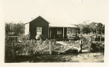
Home of Campbell family, early residents of area. Also a photograph in book Bunga Haven on Lake Bunga number 00694 page 62 of the house called Burton's Farm House, 105 Lake Bunga Road originally known as the Wilson Farm named Cora Lynn built by Robert James Wilson. Vera Harbeck nee Wilson wrote stories for the Weekly Times c 1916 using the name of the family home as her place of residence.Sepia photograph of timber dwelling at Lake Bunga. Timber cladding appears to be oiled. Wire fence supported by round sappling post. Lakes Entrance Victoria .houses, local history -
 Lakes Entrance Historical Society
Photograph - Historic House, 1999
Some early residents : Pa & Ma Powell, Race Mitchelson. Still occupied 2012.|Also One other colour photograph similar.Colour photograph of a timber residence with hipped roof situated at 30 Church Street. Front door has window lights beside and above door. Sash windows. Lakes Entrance Victoriahouses, heritage study -
 Linton and District Historical Society Inc
Photograph, Unidentified Family at Mt Bute Station, early 1900s
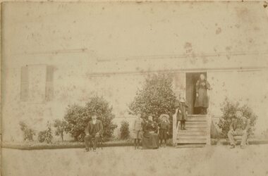
Mt Bute Station was a pastoral lease originally established c.1840 by Duncan Hoyle. The lease was later transferred to Charles and William Oakley (c.1853), and then to Matthew Hamilton Baird (c.1858). Sir Samuel Wilson acquired the lease in 1872 and purchased the property in 1873. Mt Bute was subdivided for soldier settlement blocks after World War I. The home block - house and 700 acres - is currently owned (2018) by the Collins family.Faded photograph mounted on cream-coloured card, which shows a family outside the residence at Mt Bute pastoral station. The photograph is undated but is believed to have been taken in the early twentieth century. Photograph shows two men, and a woman seated in chairs outside a house. A row of shrubs is across the front of the house. Two young boys are standing either side of the woman. Two young girls are standing on the steps leading to the entrance of the house. The people in the photograph have not been unidentified. A copy of the photograph was made in 2019 and is with the original.mt bute station [pastoral station] -
 Linton and District Historical Society Inc
Photograph, Traquair House, 90 Sussex Street, Linton, 2014
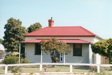
Now called 'Traquair House, this building in the early `1860s was the first Bank of New South Wales building, consisting of a banking chamber and residence. It was renovated in the 1870s, and after the bank moved its premises in 1904 it became a family home.Colour photograph of rendered brick building with five arched windows and a door facing onto the street. A chimney can be seen to the left. The words "NEW SOUTH WALES" are visible across the building.buildings, houses, bank of new south wales, traquair house, 90 sussex street linton -
 Eltham District Historical Society Inc
Photograph - Digital Photograph, Marguerite Marshall, Former Head Teacher's residence, Eltham Primary School, Dalton Street, Eltham, 7 September 2008
Built in 1891 for Head Teacher John Brown. His predecessor and the school's first Head Teacher, John Clark, lived in his own house 'Shoestring' in Metery Road, adjacent to the school. At the time of this photograph, the building was being used for before and after school care. Its present-day (2023) use is for school administration offices. Covered under Heritage Overlay, Nillumbik Planning Scheme. Published: Nillumbik Now and Then / Marguerite Marshall 2008; photographs Alan King with Marguerite Marshall.; p49 The former head teacher’s residence on 690 Main Road, was built in 1891 for the head teacher, John Brown. His predecessor David Clark lived in his own house known as Shoestring at Metery Road, possibly built in the late 1850s. With the school, Wingrove and Jarrold Cottages, it makes up the original Eltham township south of Dalton Street’s only group of 19th century buildings. The two Monterey Pines were popular vegetation in the late 19th and early 20th centuriesThis collection of almost 130 photos about places and people within the Shire of Nillumbik, an urban and rural municipality in Melbourne's north, contributes to an understanding of the history of the Shire. Published in 2008 immediately prior to the Black Saturday bushfires of February 7, 2009, it documents sites that were impacted, and in some cases destroyed by the fires. It includes photographs taken especially for the publication, creating a unique time capsule representing the Shire in the early 21st century. It remains the most recent comprehenesive publication devoted to the Shire's history connecting local residents to the past. nillumbik now and then (marshall-king) collection, dalton street, eltham, eltham primary school, headmaster's residence, main road, state school no. 209 -
 Eltham District Historical Society Inc
Photograph - Digital Photograph, Marguerite Marshall, Jelbart home, 93 Arthur Street, Eltham, 11 November 2006
Situated at the top of the hill in Arthur Street, the former Jelbart residence and barn were part of a major change that transformed Eltham's character in the late 1960s. Built from the mid 1940s through mid 1950s when Eltham was a rural community, the Jelbrat residence and barn are all that remain of a family property of some 250 acres (100 ha). With growing population pressures, in the late 1960s, owners Ron and Yvonne Jelbart decided to subdivide their property creating the Woodridge Estate in the early 1970s, a major factor towards the transformation of Eltham to the suburb it is today. The Jelbarts had moved to Eltham in the early 1940s when they purchased a poultry farm in New Street, now Lavendar Park Road. (The local Black Friday bushire of January 13, 1939 had started at C.A. (Clarrie) Hurst’s Eltham Poultry Farm and Hatchery in New Street.) Jelbart was primarily a businessman importing office machinery but desired farm beef and dairy cattle so the couple purchased the virgin bushland at what was then at the end of a dirt road, Arthur Street. With post war shortages of most building materials, they followed the example of the Eltham Artists' Colony (later called Montsalvat) and built thier home from mud-bricks and recyclked materials. The barn was first to be completed in 1945 which they made their home whilst building the main residence. It took eight years to complete the two buildings. Both the main residence and the barn are now separate homes, and along with the remaining property being sub-divided further in 1998 are now part of the Kinloch Gardens Estate at 93 Arthur Street. Covered under Heritage Overlay, Nillumbik Planning Scheme. Published: Nillumbik Now and Then / Marguerite Marshall 2008; photographs Alan King with Marguerite Marshall.; p139 Standing on a hilltop at Arthur Street, Eltham, the Jelbart residence and former barn were part of a major change that transformed Eltham’s character in the late 1960s. Built from the late 1940s to the mid 1950s when Eltham was a rural community, they are all that remain of what was once a family property of around 250 acres (100 ha). As population pressure increased in the late 1960s, owners Ron and Yvonne Jelbart, decided to subdivide their property. The break-up of this property into the Woodridge Estate in the early 1970s, was a major factor towards transforming Eltham into the suburb it is today.1 Although standing only a few minutes from Eltham’s busy hub and hundreds of houses in Woodridge, scarcely any urban sound disturbs the peace. Views from the two buildings are almost exclusively of trees and extend to Mt. Dandenong to the south-east, the Great Divide to the north, and Melbourne city to the south-west. The Jelbarts had lived in Eltham since the early 1940s when they bought a poultry farm in New Street, now Lavender Park Road. Although Jelbart was primarily a businessman importing office machinery, he was keen to farm dairy and beef cattle, so the couple bought rough bushland at what was then the end of Arthur Street. But a shortage of building materials following World War Two hampered their plans to build their new home, so they followed the example of the Eltham Artists’ Colony (later called Montsalvat) and used mud-bricks and recycled materials.2 With great determination the family and friends constructed their house. Massive timber frames and huge quantities of mud-bricks were made on site. The barn was built first in 1945, and two years later, while camping inside, the Jelbarts started building their house. It took eight years to construct the two buildings, even with the help of professional tradesmen. The buildings, with timber frames infilled with mud-brick and plastered, are reminiscent of the English Tudor style. The Jelbarts are of Cornish stock. Much of the timber framework came from demolished bridges or warehouses, and recycled slate was used for roofs and floors. Quality second-hand materials were readily available in the late 1940s and 1950s when there was much demolition in Melbourne and little respect for heritage. A former 19th century Toorak mansion Woorigoleen provided the magnificent stone fireplace, the timber panelling and the parquetry floor in the living room. The large stone gateposts at the entry of the property came from Melbourne University. Almost no mechanical equipment was used to build the 55 square house and the 25 square barn. Massive timber frames were erected using block and tackle pulleys and timbers were shaped, sawn and drilled by hand. Son and architect Ian, with his family, have lived in and extensively renovated both buildings since the early 1970s. Ian transformed the steep ridge of the property into a plateau, where the main house Kinloch stands, surrounded by terraces and lawns. The grounds retain many native plants, including massive yellow boxes – some nudging 80 years. Ian attached 70 metres of pergolas draped with wisteria, roses and grape vines, to three sides of the house. The beautiful garden is featured in the book Through the Rose Arbour by Rosemary Houseman. The two-storey barn – now a house – retains traces of its original use. The cow-shed with milking and feed-rooms, and the machinery-shed remain. The house, separated on the ground floor by a breeze-way, soars two storeys and includes a mezzanine. These are connected by spiral staircases, to timber-beamed and plaster-lined high-pitched ceilings. The house also descends to a wine cellar. Curiously the roof is of corrugated iron on the south and slate on the north, to save costs. Small-paned windows and three French doors open onto the front lawn, which extends to Jelbart Court.This collection of almost 130 photos about places and people within the Shire of Nillumbik, an urban and rural municipality in Melbourne's north, contributes to an understanding of the history of the Shire. Published in 2008 immediately prior to the Black Saturday bushfires of February 7, 2009, it documents sites that were impacted, and in some cases destroyed by the fires. It includes photographs taken especially for the publication, creating a unique time capsule representing the Shire in the early 21st century. It remains the most recent comprehenesive publication devoted to the Shire's history connecting local residents to the past. nillumbik now and then (marshall-king) collection, eltham, arthur street, jelbart barn, jelbart home, kinloch gardens -
 Eltham District Historical Society Inc
Photograph - Digital Photograph, Alan King, Heritage apple tree, 24 January 2008
This old apple tree situated beside the Plenty River Trail at Greensborough has been associated with Melbourne Founder John Batman. Known as Batman's Tree, this apple tree is on the bank of the Plenty River near Leischa Court, Greensborough. It is said that Melbourne Founder John Batman may have planted the tree and later signed his treaty here with the Aboriginal people. It still bears fruit and its recorded on the National Trust's Register of Significant Trees, as the oldest apple tree in Victoria. Published: Nillumbik Now and Then / Marguerite Marshall 2008; photographs Alan King with Marguerite Marshall.; p7 Was This John Batman's Tree? An apple tree on the bank of the Plenty River near Leischa Court, Greensborough, is believed to have belonged to Melbourne’s founder, John Batman. It could also stand where John Batman signed his famous treaty with the Aboriginal people.1 Known as Batman’s Tree, it still bears fruit and is recorded on the National Trust’s Register of Significant Trees, as the oldest apple tree in Victoria. It is ‘Believed to have been planted by either John Batman, (c1837) or Martin Batey (1841)’.2 In 1966 a Horticultural Adviser, Mr Rolfe, after extensive questioning of aged Greensborough residents, wrote: ‘it thus seems fairly certain that the old tree on the banks of the Plenty River is an original Batman apple tree’. Mr Rolfe said that the tree stood on a spot formerly called Wattle Bend: ‘one of the sites claimed to be where John Batman signed his famous treaty with the aboriginals. ‘My main source of information has been interviews with people who attended school in the Greensborough area from 70 to 80 years ago. Their parents were close to the days when Melbourne was founded so information passed on by word of mouth.’ Around 1920 the tree was struck by lightning and a concrete block was placed in the split. The concrete is inscribed with the date 1841 when the tree was thought to have been planted. Not everyone agrees with Mr Rolfe however. Former secretary of the Nillumbik Historical Society, Kevin Patterson, said there was no written evidence to support the claim. But he said the tree had been known to locals for decades as Batman’s Tree. In the 1920s a holiday resort in the area advertised: ‘Come to Greensborough and see John Batman’s tree’. Mr Patterson said it was thought that when Batman died in 1839 his land was sold and a Greensborough man Frederick Flintoff bought seedlings from his orchard for £1 each. This was the only one left.3 Mr Rolfe said: ‘If planted in 1837, or even a few years later, it undoubtedly is the oldest living apple tree in Victoria. Title records of the property on which the tree grows show that the land was a crown grant of F D Wickham in 1840. Mr Wickham was reputed to be a friend of John Batman. All the early settlers prior to the crown grants were squatters, by virtue of Batman’s treaty. This treaty was revoked by the then New South Wales Government, so it is likely that Wickham or an agent was in occupation before 1840. ‘According to Mrs Mavis Latham (John Batman – Great Australian Series, Oxford University Press) when Batman came to Port Phillip in 1835 he brought fruit trees with him. He failed to get a crown grant for his selection on Collins Street, which included 20 acres (eight ha) of orchard and cultivation. His residence became the Government Office and Melbourne grew from wild bushland in 1835 to a town of over 20,000 people by 1841. It is possible Batman visited Wickham and presented him with a tree.’ However a Flintoff descendant in 1933 said Frederick Flintoff ordered his bailiff Martin Batey to transplant the Batman Tree from the Spencer Street orchard to its present site as a memorial to his friend Batman.4 Mr Rolfe spoke to many people, including descendants of the Bateys and Flintoffs and pupils at the Greensborough Primary School. Many had gained their information from a ‘very highly respected’ head master Lewis Amiet at the Greensborough School from 1895 to 1917. He must have gained this information from residents in the district and had this information been incorrect, the parents of the children would have promptly corrected him.’ One woman who attended the school before Mr Amiet’s appointment, said the previous teacher also taught that the tree on the Plenty River was a Batman tree, Mr Rolfe said.This collection of almost 130 photos about places and people within the Shire of Nillumbik, an urban and rural municipality in Melbourne's north, contributes to an understanding of the history of the Shire. Published in 2008 immediately prior to the Black Saturday bushfires of February 7, 2009, it documents sites that were impacted, and in some cases destroyed by the fires. It includes photographs taken especially for the publication, creating a unique time capsule representing the Shire in the early 21st century. It remains the most recent comprehenesive publication devoted to the Shire's history connecting local residents to the past. nillumbik now and then (marshall-king) collection, greensborough, john batman tree, plenty river trail -
 Eltham District Historical Society Inc
Photograph - Digital Photograph, Alan King, Original Kangaroo Ground Primary School No. 2105 building, Eltham-Yarra Glen Road, Kangaroo Ground, 28 December 2007
Kangaroo Ground's first school began in 1851 with 22 pupils from the district's ten families. It was a single room school located further south on the site, which also served as a Presbyterian church. The first teacher was Andrew Ross. The school building was used as a Post Office between 1854 and 1858 and during 1857 also served as a Court of Petty Sessions. With a growing farming community, a new building was warranted and the original Sate School No. 352 was closed and a new building, State School No. 2105 was oipened October 1, 1878. A residence for Head Teacher Henry Wallace School was erected in 1879 attached to the left of the school building. That residence is now home to the Andrew Ross Museum, which opened in 1993. Covered under Heritage Overlay, Nillumbik Planning Scheme. Published: Nillumbik Now and Then / Marguerite Marshall 2008; photographs Alan King with Marguerite Marshall.; p35 In a corner of the Kangaroo Ground Primary School playground stands an old weatherboard building. This structure, attached to the former teacher’s weatherboard residence facing Main Road, first served as a school in 1878. The former residence, built in 1879, houses the Andrew Ross Museum, which opened in 1993. It is named after the school’s first teacher,1 who also founded The Evelyn Observer newspaper, which began on the site in 1873. Later the printing presses were moved to brick newspaper offices by the Kangaroo Ground Hotel, which became the Shire of Eltham offices. However Kangaroo Ground’s first school began in 1851 for 22 pupils from the district’s ten families, in a slab building further south on this site. Andrew Harkness and other settlers campaigned for the building, which was built on half an acre (0.2ha) donated by local farmer, James Donaldson. Builder was Samuel Furphy, father of the novelist Joseph.2 The single room measuring 30 feet x 18 feet (9m x 5.5m), was unlined and the green slabs shrank, allowing the wind and rain entry through cracks except when they were stuffed with paper.3 The building served as a Presbyterian church as well as a school, where fees were 18 pence a week for education. Young men also attended evening classes there in winter. At one stage, a corner of the room was curtained off for the schoolmaster’s living space, and the platform, which was used for sleeping, was also the pulpit during church services. Teacher Andrew Ross also took church services when the minister was unable to attend, which happened frequently as he had long distances to travel on the bad roads. In 1857 the school building was also used as the Court of Petty Sessions, and from 1854 until 1858, it served as a post office. During the gold rush fossickers on their way to the Caledonia Diggings at Queenstown (now St Andrews) prospected the district, but did not remain long, as the fields were not rich in gold. But the farming community grew, until by 1878 the population warranted the building of State School No 2105 – the present one-roomed tongue-and-groove lined building measuring 49 feet x 18 feet (15m x 5.5m), to accommodate 60 children. The old school, No 352, was closed, and the new one opened on October 1, with Henry Wallace as head teacher, assisted by work mistress Annie Johnston. Early teachers included Messrs Smith, Hamilton and Prosser, with sewing teachers Misses Sweeney, Limerock and Oliver. In the early 1920s a small room was built on the front veranda of the teacher’s residence, and used as a State Savings Bank agency until about 1934. In 1928 the schoolroom’s three-tiered floor was replaced by a flat floor and teacher’s platform (which has since been removed). A half-glassed partition wall then divided the large room into two rooms in which the old style form-type desks were replaced with dual desks. The small playground, surrounded by pine trees and a picket fence, was extended in 1931 with an additional acre or so (0.4 ha) of land. During World War Two the school faced closure because of a fall to seven in the enrolment, but by 1946 it had increased again to 45. Mr Eric Morgan was head teacher and Mrs Margaret Banks was assistant head teacher, a position she held for ten years. In 1955, under the head teacher Mr V Gardiner, who taught there for 13 years, the school won a prize for the best-kept garden and school ground in the inspectorate. A district subdivision increased the enrolment in 1968 to 65 and a bus service was established. After the hall which had been used for lessons was demolished late that year, the pupils met in the original fire brigade meeting room (now the tennis club, diagonally opposite the general store). The new school building with a storeroom and staffroom was built in 1974.This collection of almost 130 photos about places and people within the Shire of Nillumbik, an urban and rural municipality in Melbourne's north, contributes to an understanding of the history of the Shire. Published in 2008 immediately prior to the Black Saturday bushfires of February 7, 2009, it documents sites that were impacted, and in some cases destroyed by the fires. It includes photographs taken especially for the publication, creating a unique time capsule representing the Shire in the early 21st century. It remains the most recent comprehenesive publication devoted to the Shire's history connecting local residents to the past. nillumbik now and then (marshall-king) collection, kangaroo ground, andrew ross museum, eltham-yarra glen road, kangaroo ground primary school no. 2105, kangaroo ground state school, state school no. 2105 -
 Eltham District Historical Society Inc
Photograph - Digital Photograph, Alan King, Eltham Court House, 730 Main Road, Eltham, 28 December 2007
The Eltham Court House is Eltham's oldest public building. It was classified by the National Trust in 1977. In 1857 five Eltham residents petitioned the licensing magistrates of the Heidelberg district asking for better police protection, including from itinerant gold prospectors who turned to crime when their quest was unsuccessful. In response the Eltham Courthouse was constructed in 1860. Over the years it has also been used for other activities, including for electoral polling purposes, inquests, early meetings of the Eltham Roads Board and even as an overflow classroom. This type of localised solution is characteristic of the self-reliance preserved in Eltham today. The court house is an important symbol of the spirit which makes Eltham distinctive as a community. The Eltham Courthouse is historically significant because its construction was intended to emphasise the centralised control over law and order in the Colony of Victoria in the wake of the 1852 Snodgrass committee report on the Victorian police force and the resulting Police Regulation Act (1853). The nature of the Court House planning and use of architectural devices make the building's function easily interpreted. The arrangement of rooms, with public entry and clerical rooms to the rear, and the use of raised floor levels throughout these spaces to signify relative rank is easily perceived. The distinction in entries, public, magistrate and person-in-custody, and the existing court furniture enhances appreciation of this building. The Eltham Court House is one of only two intact examples in the state of this simple design with projecting entry. The building is of architectural significance because it retains intact early features. These include use of handmade bricks, simple decoration, roof trusses, timber ceiling boards, original windows, doors and associated hardware and a collection of court furniture. Additions to the court house have been done in a manner which did not interfere with the fabric of the original building. Typical cases heard before the Court of Petty Sessions included financial debt, straying livestock, theft, assault, drunkenness, public disorder, truancy, motor vehicle offences, unregistered animals and failing to have children attend school, or be vaccinated. The courthouse operated for over 120 years before it closed in 1985. In April 2021, Nillumbik Shire Council authorised restoration of the building and furnishings. The extensive works required for the total restoration of this highly valued heritage building was undertaken by Ducon Building Solutions and other specialist contractors. Covered under Heritage Overlay, Nillumbik Planning Scheme. Victorian Heritage National Trust of Australia (Victoria) State significance Published: Nillumbik Now and Then / Marguerite Marshall 2008; photographs Alan King with Marguerite Marshall.; p65 A demand for better police protection resulted in the building of the Eltham Courthouse and the police residence beside it. In 1857 five Eltham residents petitioned the Heidelberg district licensing magistrates. They pointed out that Eltham had two hotels, a population of about 1000, and many strangers employed on the public roads. Yet the nearest police were at Heidelberg eight miles (12.8km) away, or at the Caledonia Diggings 21 miles (33.7km) away.1 Subsequently the courthouse and then the police residence, near the corner of Main Road and Brougham Street, were built in 1859/60. The courthouse is Eltham’s oldest public building and the National Trust classified it in 1977. It ceased operation in 1984 and has since been used by local groups. There are only six other known examples of similar small brick country courthouses in Victoria . For £536, a Mr Duncan built the courthouse – a neat, narrow, oblong building with handmade orange bricks. Its gabled roof and porch are covered with brown slate tiles and it has 12-paned windows. Inside, the roof is peaked and the courthouse is still ventilated by oblong slits near the ceiling. Most of the fine carved timber and upholstered furniture is original. The original prisoners’ door, now permanently closed, led from the police station to the dock. Builders, Langridge Wright and Witney built a timber police station (since demolished) and a brick residence to its north,2 for £1150/7/-. Built around the same time were the lock-up behind the residence, also later demolished, and the two-storey orange brick stables. The former police residence also has a brown slate roof and handmade bricks. The front veranda roof is made of corrugated iron, as is the roof of the back weatherboard extension. The application for police protection was approved within a few months and police operated from a cottage rented at ten shillings a week and owned by William Jarrold. This was probably the one at the corner of Main Road and Dalton Street called Jarrold or White Cloud Cottage. In 1858 a second constable was appointed to Eltham following a fight at the hotel. The timber police office a replica of which was built in the early 1990s is at the building’s side. The lock-up was demolished following the relocation of the police to a new station in about 1952. The residence has been used as the Eltham District Historical Society centre since 1997. Records show court cases were held at Eltham before the courthouse was built, but the location is unknown. Some court cases were not very different from those today. In 1891 a man was charged with being drunk while in charge of a horse and was fined ten shillings. The courthouse was used for other purposes during its long history. It was probably used as a polling place as indicated by old photographs of election-day crowds outside. The Eltham Road Board met there from the early 1860s until 1868 when the Board transferred to Kangaroo Ground. During the same period the Road Board Secretary used the courthouse as an office until 1867 when it was transferred to his home at Wingrove Cottage. The courthouse was also used as an overflow classroom for the Dalton Street school in 1875. The two buildings can further link us with Eltham’s early days through Police Department correspondence. The first constable-in-charge was George Reid. In 1860 a letter to The Argus newspaper signed ‘A Sufferer’ declared the Eltham police were not active enough in their duties. The writer suggested that the ‘very snug’ police quarters were too comfortable, and he detailed various incidents including one of an alleged break-in to the Road Board Secretary’s home. But the Board Secretary, C S Wingrove, wrote to the Police Department refuting The Argus letter saying he had received full co-operation from Sen. Constable Peter Lawler.This collection of almost 130 photos about places and people within the Shire of Nillumbik, an urban and rural municipality in Melbourne's north, contributes to an understanding of the history of the Shire. Published in 2008 immediately prior to the Black Saturday bushfires of February 7, 2009, it documents sites that were impacted, and in some cases destroyed by the fires. It includes photographs taken especially for the publication, creating a unique time capsule representing the Shire in the early 21st century. It remains the most recent comprehenesive publication devoted to the Shire's history connecting local residents to the past. nillumbik now and then (marshall-king) collection, eltham, eltham court house, main road -
 Eltham District Historical Society Inc
Photograph - Digital Photograph, Alan King, St Andrews Hotel, 2 February 2008
The c1860 St Andrews Hotel, with the c1930 additions, and the Canary Island Palm, and the surrounding site to the title boundaries are historically, socially and aesthetically significant to the Shire of Nillumbik. The St Andrews Hotel is historically significant because it may have given its name 'St Andrews' to the town (another suggestion is that the name came from St Andrews church) and for its connection to Ewen Hugh Cameron (1831-1915) the prosperous local farmer, member of the Eltham Roads Board/Shire Council and local MP. It is also significant as the oldest hotel building in the former Shire of Eltham, as one of the few surviving buildings connected with the Caledonian goldfields era and as one of a handful of early structures to have survived the 1960s bushfires; the additions and alterations to the hotel reflect its long life. The hotel is socially significant because it has served as an important meeting place for more than 160 years. The Canary Island Palm is historically significant as a rare example of exotic tree planting in this rural area. The tree is aesthetically and historically significant as a local landmark and for its contribution to the streetscape and landscape value. Covered under Heritage Overlay, Nillumbik Planning Scheme. Published: Nillumbik Now and Then / Marguerite Marshall 2008; photographs Alan King with Marguerite Marshall.; p71 Built around 1860, St Andrews Hotel has changed little since it first welcomed thirsty gold diggers from the Caledonia Goldfields. The timber building, with gabled roof, beamed ceilings and a massive fireplace, is Nillumbik Shire’s oldest hotel and has always been an important community centre, particularly in its early days. Fortunately, the hotel and the near-by Canary Island Palm Tree, which is quite rare in this area, survived the 1960s bushfires, along with a few other early buildings. St Andrews (formerly Queenstown) was founded on gold, as were Panton Hill (formerly Kingstown), Research and Diamond Creek, from the mid-1850s to the 1860s. But by the early 20th century common use changed the name Queenstown to St Andrews, possibly after this hotel or after the church or the mining district.1 The Caledonia Diggings were probably named by Scottish settlers after the Roman name for Scotland, despite this land bearing little similarity to their homeland.2 Queenstown, which was proclaimed as a township in 1861, was the gold-mining centre on the Upper Diamond and in the 1850s had up to 600 European inhabitants and a small camp of Chinese on the flats along the creek. Queenstown was the administrative centre of the Upper Diamond with three hotels, a brewery and a slaughterhouse.3 It is unclear which hotel was the district’s first, as distinct from the earliest unlicensed grog shops, some of which operated in tents. John Corke Knell was one of eight unlicensed storekeepers supplying drink to miners at Caledonia in 1857, named by Sgt. McNamara of the Caledonia Police Station.4 In February 1859, Knell apparently bought most of the present hotel’s site at the first township land sales. As he was a local storekeeper, he might have first established a store there.5 Knell and his wife Eliza were early licensees of the St Andrews Hotel. The hotel had eight bedrooms – including three for public use – and the dining-room seated 30 people. It is thought they named the hotel St Andrews after Eliza’s hometown of St Andrews in Scotland. St Andrews Hotel was an important local centre in several ways. In the same building the Knells also operated a post office and general store. In 1867 Mrs Knell was appointed Deputy Registrar of Births and Deaths for Queenstown. The hotel was also used to hold inquests into people’s deaths when the police residence became too small.6 The hotel also became a fashionable destination at Christmas for parties from Melbourne. In 1868, possibly following her husband’s death, Mrs Knell applied for a temporary licence, which was then transferred to Robert Smith after their marriage in 1869. But then, possibly after Robert’s death, Mrs Smith operated the hotel until 1892. This contradicts a report in The Evelyn Observer 1882 that JC Knells of the St Andrews Hotel was granted a publican’s licence in the Queenstown Police Court. At that time he was supposed to have been dead for around 14 years! Although Mrs Smith was a respected citizen, known for her geniality and as an ideal hostess, she had a minor brush with the law when she was fined ten shillings for not lighting a lamp outside her licensed premises.7 From 1892 several publicans owned the hotel including W Atkins, from 1895. In 1909 the licensee was apparently Mrs Smith’s son, Walter Knell, who held the licence until at least the 1920s. Not surprisingly, this old hotel has attracted romantic stories. Mrs Smith is said to be seen roaming the pub in her nightdress – even though she was buried in the Queenstown Cemetery in 1911.8 A musical The Hero of Queenstown, set in the hotel, was written and produced by local actor Reg Evans in the 1970s.This collection of almost 130 photos about places and people within the Shire of Nillumbik, an urban and rural municipality in Melbourne's north, contributes to an understanding of the history of the Shire. Published in 2008 immediately prior to the Black Saturday bushfires of February 7, 2009, it documents sites that were impacted, and in some cases destroyed by the fires. It includes photographs taken especially for the publication, creating a unique time capsule representing the Shire in the early 21st century. It remains the most recent comprehenesive publication devoted to the Shire's history connecting local residents to the past. nillumbik now and then (marshall-king) collection, st andrews hotel -
 Eltham District Historical Society Inc
Photograph - Digital Photograph, Alan King, Wellers Restaurant, 150 Eltham-Yarra Glen Road, Kangaroo Ground, 23 January 2008
Originally Wellers Hotel, it was constructed by Edward Weller in 1872. Following his death in 1883 it was taken over by his widow, Mary Weller. The hotel was delicensed in 1909 and converted to a private residence. Around 1920 William Pitman bought the property, succeeded by his son Vernon who coined the term Pittman's Corner. Vernon and Isabel Pitman owned the house form 1945-1973. Following Vernon's death, Isabel remained there till her death in 1983. The property was converted to a restaurant in 1984 by owners Robert and Kath Hendry who undertook extensive renovations in 1988. Shawn and Stephanie Wolfe purchased the property from the Hendrys in 2003 and introduced live entertainment with many famous bands and entertainers from the 1960s, 1970s and 1980s performing there, including James Reyne, Daryl Barithwaite, Brian Cadd and Billy Thorpe. In 2014 the Wolfe's sold the property and the entire contents were sold at auction. New (local ) owners Gregory Anderson, Craig Jones and Steve Gist refurbished the property and relaunched it as Fondata 1872 in 2017. Covered under Heritage Overlay, Nillumbik Planning Scheme. Published: Nillumbik Now and Then / Marguerite Marshall 2008; photographs Alan King with Marguerite Marshall.; p87 A low-lying brick building at a turn on the main road, on the way to Kangaroo Ground, was once a welcome resting place for travellers. In the late 19th century Weller’s Pub, as it was called then, provided a store and an overnight stopping place and changing post for Cobb & Co coaches. The coaches were bound for the Caledonia Goldfields, near Queenstown (now St Andrews) and the Woods Point gold mines.1 Builder Edward Weller constructed the hotel and store on three acres (1.2 ha) in 1872 and after he died in 1883, his widow, Mary, continued to run the hotel, which was delicensed in 1909. This was not the first enterprise Weller ran in the district. In about 1866, he came to Kangaroo Ground and rented a general store and nine acres (3.6 ha) of land. The store, opposite the present school, was on the site of the present store and Weller also acted as the postmaster there. Mrs Weller was born in Scotland in 1841 and came to Victoria with her parents in about 1852. After two years in Melbourne the family moved to the Caledonia Goldfields where they remained for several years during which time she married Weller. The couple subsequently had five sons and five daughters. Weller’s Pub was made of handmade bricks fired from clay dug on the property. The pub must have been a haven on hot days with its 40cm thick walls throughout. One quaint reminder of its early use is that every room except the dining room has an outside door. Inside, the pub was converted to a home with extra doors connecting the inside rooms. There is no trace of the original bar room in the present dining room, where the steps leading to the cellar were bricked in. An unusual feature is the pressed metal which lines the ceilings, yet with moulding and white paint, looks like plaster. The main road once passed the back of the building and wound up to the top of the hill through a cutting. This steep hill was known to the bullock drivers in the early days, as Salvation Hill, because they were always very glad to reach its peak. After the hotel was delicensed it was converted to a private residence and extensive renovations were made, changing much of its design from a Victorian to an Edwardian style.2 Between 1912 and 1915, Gordon Cameron, a Cobb & Co coach driver and his wife rented the former hotel. Mr Cameron was related to the parliamentarian Ewen Cameron of Pigeon Bank, Kangaroo Ground, and his wife was related to Albert Pepper who owned Pigeon Bank from 1916 to 1919, when Gordon Cameron bought it. About 1920 William Pitman bought the property, which in turn was owned by his son, Vernon, who coined the name Pitman’s Corner. He and his wife Isabel owned the house from 1945 to 1973. Then as a widow Isabel Pitman lived there until her death in 1983.3 In 1984 the property was converted to a restaurant by owners P A Tribe, a barrister, his wife Sharon, and Robert and Kath Hendry. Extensive renovations maximised the splendid views of the Dandenong Ranges and the Yarra Valley.This collection of almost 130 photos about places and people within the Shire of Nillumbik, an urban and rural municipality in Melbourne's north, contributes to an understanding of the history of the Shire. Published in 2008 immediately prior to the Black Saturday bushfires of February 7, 2009, it documents sites that were impacted, and in some cases destroyed by the fires. It includes photographs taken especially for the publication, creating a unique time capsule representing the Shire in the early 21st century. It remains the most recent comprehenesive publication devoted to the Shire's history connecting local residents to the past. nillumbik now and then (marshall-king) collection, eltham-yarra glen road, fondata 1872, kangaroo ground, wellers restaurant, billy thorpe, brian cadd, craig jones, daryl barithwaite, edward weller, gregory anderson, hotels, james reyne, kath hendry, mary weller, restaurants, robert hendry, shawn wolfe, stephanie wolfe, steve gist -
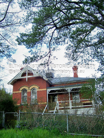
 Eltham District Historical Society Inc
Photograph - Digital Photograph, Marguerite Marshall, 'Worlingworth', 10-26 Banoon Road, Eltham, 30 January 2006
'Worlingworth', Eltham, home of noted anthropologist the late Professor Donald Thomson and his wife Dorita Thomson. Covered under Heritage Overlay, Nillumbik Planning Scheme. Published: Nillumbik Now and Then / Marguerite Marshall 2008; photographs Alan King with Marguerite Marshall.; p127 Dubbed as ‘Australia’s Lawrence of Arabia’ anthropologist Donald Thomson lived much of his life in Eltham, at Banoon Road. On his retirement as Professor of Anthropology in 1968, The University of Melbourne professorial board compared Thomson to Lawrence of Arabia because of his work for Aborigines and his controversial personality. Although Thomson is now recognised for his huge contribution, during his lifetime he suffered opposition and his life has been described as ‘tragic’.1 Thomson failed to gain the recognition as a scientist that he felt he deserved and he failed to alter government policy towards Aboriginal people. But towards the end of his life in 1970, anthropologists were moving towards the type of research he had done and the movement to grant land rights to Aborigines was strengthening. Thomson is best known for his anthropological fieldwork in Cape York, Arnhem Land and Central Australia, but he is also known for his scholarly contributions to ornithology and ecology. Thomson documented every aspect of the daily and ritual life of the Aboriginal world of Cape York and Arnhem Land in the 1930s and 1940s. The huge collection in Museum Victoria includes 11,000 photographs, 7500 items of material culture, 1000 botanical and zoological specimens and 4500 pages of field-notes.2 The film Ten Canoes used Thomson’s photographs as a source. Thomson bought the Eltham property known as Worlingworth in 1934. The single-storey 60-square house standing by the Yarra River was built in 1922-23. It is one of the last in Eltham to survive with its farm setting intact. It is also one of the few substantial residences built in the Eltham Shire from the late 19th century to the early 20th century, which signalled a major change in the area towards the residential municipality it is today.3 The original section, built in the mid 1860s, of rose pink hand-made bricks and stone quarried on the property, was incorporated in the new red-brick house built in 1922. An immense oak tree by the house grew from an acorn brought by Patrick Armstrong who first bought the land in March 14, 1862. Armstrong named Worlingworth after his forbears’ village in Suffolk, England. Worlingworth saw grand days when Commander Alan A Barlee (R.N.) bought it in 1922 after winning the Calcutta Sweep. The property then included a nine-hole golf course, a tennis court, a bowling green, a boathouse and a boat-ramp.4 For most of his career Thomson, who was born in 1901, was attached to The University of Melbourne. In 1935 he represented the Commonwealth Government at Caledon Bay in east Arnhem Land to investigate and mediate for four Aborigines accused of killing five Japanese and three Europeans. In 1938 Thomson was awarded a PhD in Anthropology at Cambridge University, and during his career, he received several medals from British Societies, who perhaps appreciated his work better than their Australian counterparts. From World War Two, Thomson suffered a string of hardships, beginning with severe wounding in Dutch New Guinea (for his military service in New Guinea he was awarded an OBE) and he was invalided from service in 1944. That year he was diagnosed with diabetes. A fire in 1946 destroyed what Thomson regarded as perhaps the best record he had made of Aboriginal life – the 20,000 feet, (6096m) of film he had shot in Arnhem Land. In 1954 he and wife, Gladys, divorced. The next year he married his technical assistant, Dorita McColl. Several times during his career Thomson had major disagreements. For instance Professor P Elkin constantly opposed his work. He also opposed Thomson when he campaigned vigorously in 1947 against the establishment of a rocket range at Woomera, South Australia, because of the threat it posed Aborigines. Thomson resigned in frustration from the Victorian Aborigines Welfare Board in 1967, after serving for ten years, because he found that his advice was disregarded. His ashes were scattered over Caledon Bay from the air.This collection of almost 130 photos about places and people within the Shire of Nillumbik, an urban and rural municipality in Melbourne's north, contributes to an understanding of the history of the Shire. Published in 2008 immediately prior to the Black Saturday bushfires of February 7, 2009, it documents sites that were impacted, and in some cases destroyed by the fires. It includes photographs taken especially for the publication, creating a unique time capsule representing the Shire in the early 21st century. It remains the most recent comprehenesive publication devoted to the Shire's history connecting local residents to the past. nillumbik now and then (marshall-king) collection, banoon road, donald thomson, dorita thomson, eltham, worlingworth -
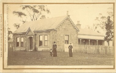 Bacchus Marsh & District Historical Society
Photograph, Stone Villa house 4 Bennett Street Bacchus Marsh 1883
The house depicted in this image was constructed in 1865 for James Young a prominent local businessman and participant in community affairs. James Young left Bacchus Marsh in 1869. In 1870 Stone Villa was purchased by local solicitor Francis Gell. In 1872 it was bought by William Collyer. For a time before 1883 it was used as a school operated by Mr Thomas Kissock and his wife. From 1883 until 1922 it was used as a parsonage by the Church of England. In 1922 it was sold to Frederick Slack as a private residence. Since Slack's ownership there have been other owners. As of April 2024 it remains as a private residence and is listed as a heritage property in the Moorabool Shire planning scheme. The identity of the two women and young girl in the foreground of the image has not been established. One of the women, and the child are possibly the wife and daughter of the Rev A.C. McCausland who was the Church of England Vicar in Bacchus Marsh from 1872 until 1885 and would have resided in this house in 1883 when this picture was produced.An early visual record of one of the most culturally and architecturally significant nineteenth century stone houses in Bacchus Marsh.Small sepia 'carte de visite' style unframed photograph on card with gold border framing photograph. Housed in the album, 'Photographs of Bacchus Marsh and District in 1883 by Stevenson and McNicoll', the Jeremeas Family Album. The photo is of a stone dwelling with an ornate gable above the inset front door which is flanked by two double windows, one of which is a bay window. The gable roof line bears ornate woodwork. A weatherboard extension with verandah has been added to the rear of the house, running north-south. A picket fence lines the block to the side of the dwelling. Two elegantly dressed women, both holding a furled umbrella, stand at the front, one holding the hand of a little girl.Printed On the front: Stevenson & McNicoll. Photo. 108 Elizabeth St. Melbourne. COPIES CAN BE OBTAINED AT ANY TIME. On the back: LIGHT & TRUTH inscribed on a banner surmounted by a representation of the rising sun. Copies of this Portrait can be had at any time by sending the Name and Post Office Money Order or Stamps for the amount of order to STEVENSON & McNICOLL LATE BENSON & STEVENSON, Photographers. 108 Elizabeth Street, MELBOURNE. Hand written on the reverse: 'Stone Villa built by James Young 1860 (sic) as his private residence, later as a school (Mr and Mrs Kissock proprietors) bought by CofE for Vicarage 1883-1922. Courtesy of Mrs J Jeremeas, Photo 1883' james young 1816-1871, houses, stone villa bacchus marsh, clergy residences, bacchus marsh vic. history, schools bacchus marsh, stevenson and mcnicoll 1883 photographs of bacchus marsh and district