Showing 391 items
matching elevation
-
 Bendigo Historical Society Inc.
Document - BASIL WATSON COLLECTION: MISCELLANEOUS CARDS AND IMAGES (LARGELY AIRCRAFT AND BASIL WATSON RELATED), c. 1916
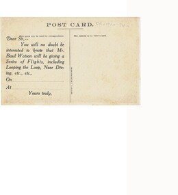
Miscellaneous cards and images (largely aircraft and Basil Watson related): a. Postcard of a seaplane over water with printed message on reverse: 'Dear Sir, -- You will no doubt be interested to know that Mr. Basil Watson will be giving a Series of Flights, including Looping the Loop, Nose Diving. ' No recipient (addressee) nor blanks filled in. b. Postcard sized engineering drawing of Supermarine P.B. 1 (end elevation); c. Postcard sized engineering drawing of Supermarine P. B. 2 (side elevation); d. humorous. Drawing on postcard (child in pram).person, individual, basil watson -
 Ballarat Tramway Museum
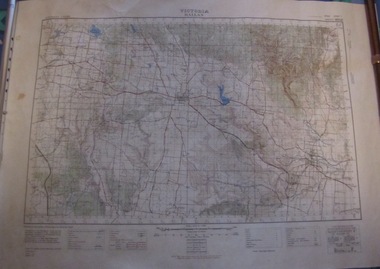
Map, Australian Survey Corps, "Victoria Ballan", 1933
Topographic map of the Ballan area - includes Bacchus Marsh and Bungaree, No. 837, Zone 7, Army Map, dated 1933, 1:63360. Shows rail lines, roads, elevations, contours. Collected with relevance to the Museum's association with the area, at Bungareetrams, tramways, bungaree, map -
 University of Melbourne, Burnley Campus Archives
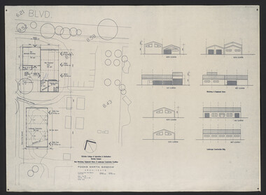
Plan, Fooks Martin Sandow Pty. Ltd, Victorian College of Agriculture & Horticulture Burnley Campus New Workshop, Equipment Store, & Landscape Construction Facilities, 1996
Plans by Fooks Martin Sandow, August 1996. Scale 1:200. (1) New Mechanics Workshop, New Equipment Store, etc. and Landscape Construction, with Elevations. (2) Layout of Equipment Store - where each piece of equipment to be placed.vcah, fooks martin sandow, equipment store, landscape construction -
 Melbourne Tram Museum
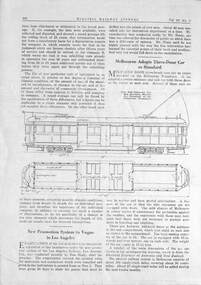
Document, Electric Railway Journal, "Melbourne adopts three-door car as standard", 1925
Article provides the operating background to the new type of bogie car then being built for the MMTB. Gives the design basis of the tram and has a side elevation of the tram. This type was known as the "W class" tramcar. Refers to the Electrical Engineer (item 6922) as the source of the drawingYields information about the Melbourne W class tram in 1925.Photocopy of an article titled "Melbourne adopts three-door car as standard" from the Electric Railway Journal of the USA, Vol 67, No. 10, page 402. tramways, tramcars, mmtb, melbourne, w class, design of new trams -
 Bendigo Historical Society Inc.
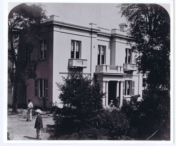
Photograph - FORTUNA COLLECTION: PLAN DRAWING FORTUNA VILLA
Plan of Fortuna villa entrance and garden elevations copied onto acetate material ( copies of original drawings). Written on top 'Fortuna Villa, G. Lansell Esq. Scale 8 feet to one inch.' Possibly originals drawn by W. Beebe.bendigo, house, fortuna villa -
 Bendigo Historical Society Inc.
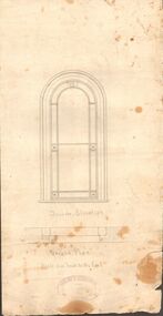
Document - MARKS COLLECTION: GROUND PLAN SHOWING WINDOW OF FORTUNA
Heavy parchment plan showing line drawing of arched window. Under window 'inside elevation', ground plan, scale one inch to the foot written in black pen. On bottom of plan: purple ink stamp 'Vahland & Getzschmann, Architects, Sandhurst'.Vahland & Getzschmann, Architects, Sandhurst.bendigo, house, fortuna villa -
University of Melbourne, Burnley Campus Archives
Plan, Alterations and Refurbishment of the Centen nial Display Building, 1990
Specification of workmanship and materials to be used in the construction of: Alterations and Refurbishment of the Centennial Display Building at Victorian College of Agriculture and Horticulture, Burnley for VCAH by Urban Spaces Pty. Ltd., Architects. Includes Plans and Elevations, and Presentation Drawings. Provenance Geoff C(?) 19.08.91. vcah, centennial -
 University of Melbourne, Burnley Campus Archives
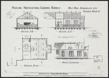
Plan, Pavilion, Horticultural Gardens, Burnley, 1916
1 large and 2 identical smaller photocopies. Pavilion, Horticultural Gardens, Burnley. Elevations and Ground Plan of "West Wing Remodelled into Science Room." Stamp GB 5173. Stamp date Dec 7th 1916. From Public Records Office.pavilion, burnley gardens, burnley school of horticulture -
 Melbourne Tram Museum
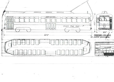
Drawing, Melbourne & Metropolitan Tramways Board (MMTB), "Proposed Box Car", Jan. 1955
Print of drawing R9495, "Proposed Box Car" - with one end and one large central door, high floor - streamliner US PCC approach. Gives side elevation and floor plan. Seats 52 passengers. Prepared 10/1/1955trams, tramways, pcc class, bogie trams, new tramcars, tramcar construction, proposals -
Port Melbourne Historical & Preservation Society
Plan - Proposed footbridge over the Lagoon, Bridge Street, Port Melbourne, 1863
Plan of proposed footbridge over the Lagoon in line of Bridge StreetIn ink on reverse, two small drawings: elevation land view over a distance of 25.00 chains (colour tinted), and Plan view, section of an unidentified street:In pencil on reverse, notation '107 Albert Street'sandridge lagoon, robert h morgan -
 Wodonga & District Historical Society Inc
Album - Hume Reservoir Australia Album - Plans and Progress Photos - River Murray Water Scheme, Department of Public Works, N.S.W, 1927
This set of photos is from a leather bound album bearing the inscription "HUME RESERVOIR AUSTRALIA" plus 'The Rt. Hon. L. C. M. S. Amery, P. C., M .P.' all inscribed in gold. It was presented to The Rt. Hon. L. C. M. S. Amery, P. C., M. P, Secretary of State for Dominion Affairs on the occasion of his visit to the Hume Reservoir on 2nd November 1927. This album is of local and national significance as it documents the planning and development of the Hume Reservoir up to 1927. It was the largest water reservoir in the British Empire. The album records the pioneering engineering work that went into its construction.1. Locality Plan and Plan of Dam. The dam is about ten miles by road upstream from Albury and about three-quarters of a mile below the confluence of the Mitta Mitta River and the Murray River. Its main features consist of a concrete portion across the bed of the river with earth embankment at both ends. The foundations throughout are on hard granite, found at an average depth of about 40 feet below the surface, the centre line being located to take advantage of the most favourable rock levels.Heading on page "WORKS UNDER RIVER MURRAY WATERS AGREEMENT/HUME RESERVOIR" Beneath top diagram "FIG. 1. ELEVATION" Beneath second diagram "FIG. 2. PLAN" On map "LOCALITY PLAN"hume reservoir australia, river murray waters scheme, hume weir diagrams, hume weir location -
 Bendigo Military Museum
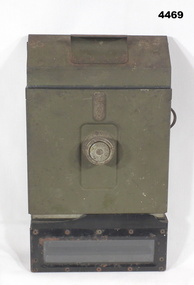
Equipment - PERISCOPE, TANK, C.1942
Believed to have come from a Sherman Tank, c. WWII.Main frame is rectangular, painted jungle green. Bottom viewer is metal with glass window. Top viewer is made of bakelite with glass window. On the rear viewer side are 2 dials and a brass ?? that adjust elevation and deflection. The rear panel has a large ?? knob.The side has a plaque "PERISCOPE M4 - MINNEAPOLIS - HONEYWELL REGULATOR COMPANY. No 54340 1942 USA"wwii, sherman tank, periscope -
 Federation University Historical Collection
Documents, J.H. Brown, Ballarat School of Mines Cyanide Plant and Caretaker's Cottage, 1914
The Ballarat School of Mines building along Albert Street were moved or demolished to make way for the new Engineering Workshop. William Henry Middleton was President of the Ballarat School of Mines from 1912 to 1940.Particulars for removal of the Ballarat School of Mines Caretaker's Quarters and Cyanide buildings are handwritten onto a foolscap page (.1). Three plans are hand-drawn in pencil, these are: (.2) Cyanide Building (.3) Caretaker's Quarters (.4) Caretaker's Quarters - South End Elevationballarat school of mines, new engineering workshop, j.h. brown, william middleton -
 Federation University Historical Collection
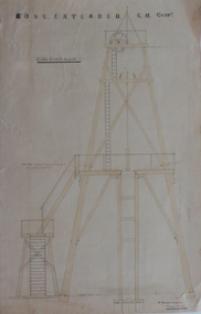
Plans, Plan of Truck Road for Kong Extended G. M. Company, 1887
3 hand drawn plans, 2 with orange and blue shading, of a truck road .1) hand drawn poppet head and road, timber specifications and iron bolts .2) hand drawn plan of poppet head .3) elevation and plan of mine workings plans, kong extended gold mining company, w. watson, poppet head, truck road -
 8th/13th Victorian Mounted Rifles Regimental Collection
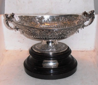
Rosebowl, Subalterns Challenge Cup, 1893 circa
Presented to the 8th/13th Victorian Mounted Rifles Regiment RAAC by its affiliated regiment the 8th Royal Irish Hussars as part of a gift of regimental property when a reorganisation of British cavalry regiments was being undertaken.Silver rose bowl mounted on black shellacked wooden base. Bowl is oval in plan view and boat-shaped in elevation with human figurines as handles. Designation of the bowl as the Subalterns Challenge Cup inscribed on side of bowl while winners are inscribed on wooden base.On side of bowl: "Subalterns Challenge Cup Presented to Lieut.Col. Davidson and the Officers 8th Hussara by major C G Poley on leaving the Regiment May 1893" and on base: "Won at Wetherby 1896 Lt O'Brien br:g "Baccarat" Owner Won at Wetherby 1897 Lt F J C Howard's b.m Moonshine aged Owner 12st 3lb Won at Fethard 1898 Lt E A O'Brien br.g Baccarat Owner 12st 3lb Won at Mullaboden 1899 Lt E M Jennings b.g May Boy Owner 12st 3lb Won at Aldershot 1904 Lt H F Partridge's b.g Loch Lomond aged Owner 12st.3lb"8th hussars, rose bowl, regimental silver, horse racing, subalterns challenge cup -
 University of Melbourne, Burnley Campus Archives
Plan, L.R.B. Simmons, New Soil Science Laboratory, 1973
Plans by Govt. Of Victoria Public Works Dept.: L.R.B. Simmons (Senior Project Architect), D.C. Bradbury (Chief Architect), Drawn by Aldo Bellarmo. A. Proposed addition to existing laboratory. B. Plan of Section and Elevation of proposed new Soil Science laboratory.laboratory, glasshouse, l.r.b. simmons, d.c. bradbury, aldo bellarmo -
University of Melbourne, Burnley Campus Archives
Plan - Photocopy, New Cottage for Caretaker Royal Horticultural Gardens Burnley 1897, 1897
Photocopies. New cottage for Caretaker, Royal Horticultural Gardens Burnley (1) Elevations, Ground floor and Roof plans. Drawing No 1 dated 5th March 1897 GB 5198. (2) Detail Drawings. Drawing No 2. From Public Records Office.Signed SEM (?) 5-1-97; J. Fisher, F.J. Moore (?) 5 Mar. 97caretaker's cottage, burnley gardens -
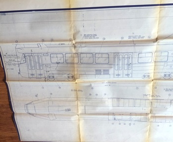 Melbourne Tram Museum
Drawing, Commonwealth Engineering - General Arrg't MMTB Tram
Drawing showing the General Arrangement of a new tram for Melbourne, MMTB, first dated 12-3-1974. Gives a list of drawings, shows the plan and elevations of the tram that became the Z class tram, the first one entering service in 1975. Has a list of amendments along the bottom edge.Yields information about the design process of a new tram by Commonwealth Engineering. At the time, the design and drawing office was based in Granville NSW.Print of Commonwealth Engineering, Granville NSW drawing number L01-10119 Revision F, titled "Commonwealth Engineering - General Arrg't MMTB Tram". Drawing Number and revision number written on the rear of the sheet.trams, tramways, commonwealth engineering, z class, comeng, new trams, drawings, mmtb -
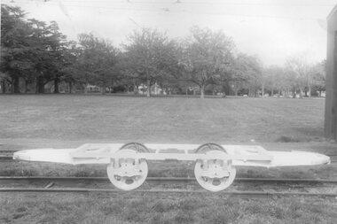 Ballarat Tramway Museum
Photograph - Black & White Photograph/s, Dave Macartney, 1987
Black and white side elevation photograph of the completed underframe of the Horse tram No. 1 in front of 5 road at the museum depot, June 1987, taken at same time as photograph in Reg. No. 737 and 750. Note the truss rods of the cable truck have yet to be fitted.trams, tramways, horse tram no. 1, btps, tramcars, reconstruction , tram 1 -
Bendigo Historical Society Inc.
Plan - SANDHURST BOYS CENTRE SITE PLANS: LISLE STREET UNITS
16 Working drawings including Floor Plans and Elevations Prepared by Michael DeVincentis, Architects; Wellington St Strathfieldsaye. October-November 1995. Scale 1:200. No 9538. Also Survey Plan for Lot 69D 3950 Sq m. Location unknown 16.02.2023.plan, bendigo, institutions, victoria. department of planning and development -
 Federation University Historical Collection
Photograph - black and white, Clare Gervasoni, Ballarat School of Mines M.B. John Buildings, 2016, 08/09/2016
The M.B. John Building (Building K), a three storey, face red brick, restrained Late Twentieth Century International styled building with an elongated, cuboid form (defined by the parapeted facades) that is offset by projecting exposed concrete framed, round‐arched entrance and stair wells on the east (Albert Street) elevation (the centrally located entrance breaking the brick façade with glazing). The facades are also characterised by banks of aluminium framed, horizontal ribbon windows, which wrap around the building corners. Metal shades project beyond the windows, while post‐supported bullnosed verandahs and hoods and projecting concrete stairs are other features. On the west elevation, the cuboid façade is punctuated by projecting curved concrete and glazed, elongated bays at first floor level. (David Rowe/Wendy Jacobs)Colour photograph of a red brick building on Albert Street. It was build to house trade workshops and Ceramics at the Ballarat School of Mines. m.b. john, m.b. john building, ballarat school of mines -
 Kiewa Valley Historical Society
Plan - Mt Beauty House
Mt Beauty was a construction town built from 1948. The houses were English Pre-cut Types - several of each type were erected with several variations. This house had 3 bedrooms and is dated as 'traced on 18 Dec. 1956'. Mt Beauty is a construction town built by the SECV during the Kiewa Hydro Electric Scheme for workers and their families. Houses were provided along with many other facilities eg. schools. This house plan is a good indication of the quality of housing provided at the time eg. laundry, toilet etc. Large sheet with title at top "State Electricity Commission of Victoria" showing 'front', 'right' and 'left' elevations and the 'floor plan'. Printed at the bottom - 'Kiewa Scheme / Mt Beauty Housing / English pre-cut Type 3B ILA /. There are further notes printed at the bottom of the sheet.mt beauty housing, english pre-cut type housing, house plan, state electricity commission of victoria -
 Frankston RSL Sub Branch
Clinometer
Field clinometer MK VI used in conjunction with the QF 25 PDR field gun. This device was mounted on a fitting at the breech end of the gun barrel and used to accurately indicate the elevation of the gun barrel. The device is calibrated in degrees and minutes and is adjustable enabling the weapon to be accurately aimed.ww2, 25 pdr, qf 25 pdr, 25 pounder, field gun, clinometer, field clinometer mkvi, field clinometer, clinometer mkvi -
Port Melbourne Historical & Preservation Society
Plan - Port Melbourne Yacht Club, John Adam, Architect, 1960s
Plans for Port Melbourne Yacht Club new dinghy building 1962. .01 Storage layouts - sketch plan .02 Plan of new dinghy building .03 Location and pile plan .04 Working drawing - site elevations .05 Working drawing - plan view sport - yachting, built environment - recreational facilities -
 Federation University Historical Collection
Plan, Plan for the Art Deco Facade on the Ballarat School of Mines Museum, c1920
Two hand-drawn and shaded architectural plans for the remodeling of the old Museum. .1) Plan for a new facade for the former Ballarat School of Mines Museum (formerly the Ballarat Wesleyan Church) showing front elevation. .2) Detail of front of the former Ballarat School of Mines Museum.ballarat school of mines, buildings, ballarat school of mines museum, art deco, former ballarat wesleyan church, grigsby, "a" hall -
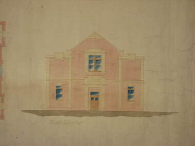
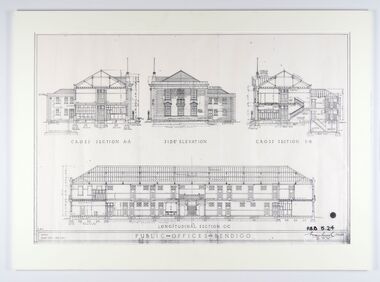 City of Greater Bendigo - Civic Collection
Work on paper - Architectural Drawing, City of Bendigo, Public Offices Bendigo, 23 November 1928
Mounted plan drawings for Public Offices in Bendigo.Cross Section A-A / Side Elevation / Cross Section B-B / Longitudinal Section C-C / R.M.B. / Scale: Eight feet - One Inch / PUBLIC OFFICES BENDIGO ? P.B.B. 5.24 / (signature) / Chief Architect / 23.11.24city of greater bendigo administration item -
 Vision Australia
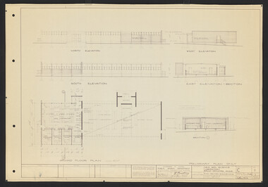
Plan - Image, Royal Victorian Institute for the Blind Extension to Bulk Store, 27/8/1925 (according to Mosiac entry)
In this undated drawing, believed to have been done in 1925, an existing bluestone store was extended out into the courtyard area. The extensions were on the south and west elevations, and the drawing includes a floor plan of these areas. Noted on the plan is the removal of fireplaces that existed in this building, the location abutting the Alfred Hospital reserve and location of the motor room.1 architectural plan of extension to bulk storeStephenson & Meldrum, Architects 374 Little Collins Street Melbourne Phone: 6990 On the back: Widening of old bluestone store plans & specroyal victorian institute for the blind, plans -
 St Kilda Historical Society
Photograph, Eildon, c. 1872
Barham House, now Eildon, built by Edward Green c 1853. Three bay, two storey Regency style house, with single storey portico. This is the original core of the current building Eildon which now has two storey bays at each end of this elevation added c1873. Of note is five children in the foreground. black and white photograph, mounted, copy, good condition.Eildon Grey St -
 Federation University Historical Collection
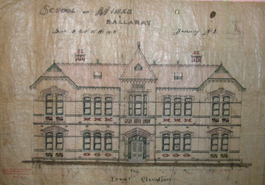
Plan, Ballarat School of Mines New Classrooms (now Administration Building), 1899, 16/02/1899
In 1900 this building was described as 'handsome in design, well lit, well ventilated, commodious - containing Council room, office, chemical laboratory, mineralogical laboratory, students room and six lecture rooms. Original hand coloured plan on linen of the Ballarat School of Mines New Classrooms (in 2014 known as the Federation University Australia SMB campus Administration Building). The plan shows the front elevation, section on line, ground and 1st floor plan. Copy in black frame with cream mount.ballarat school of mines, new classrooms, administration building, architectural plans, a building -
Bendigo Historical Society Inc.
Plan - MARKS COLLECTION: PLAN OF ALTERATIONS AND ADDITIONS TO THE PRIVATE RESIDENCE OF GEO. LANSELL ESQR
Plan for the alteration and additions to Fortuna Villaa, the private residence of George Lansell Plan shows southern, eastern & western elevations, floor and roof plan for the additions to the residence Coloured hand drawn construction plan Plan is undated plan has severe damage on LHS and bottom of the sheet