Showing 5313 items
matching flood-marker-orbost
-
 Orbost & District Historical Society
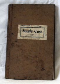
minute book, 10.2.1950 - 11.5.1961
The Orbost Rifle Club existed in the early 20th century. (There are records from 1900). It folded in the late 1970's. The secretaries at the time of this book were D.Towers and ? Healey.arget shooting is one of the oldest organised sports in Australia. Records date back to the British Marines at Sydney Cove in 1788. The Victorian Rifle Association (VRA) was formed in 1860. One of the most important adjuncts to the militia system from 1903 to the re-organisation of 1912 was the role played by the Rifle Club movement in Australia. At the time, these clubs were seen as the reservoir of manpower for a potential guerrilla force should any invasion occur. For Australia, the invasion fear was uppermost in the minds of the population. So important were the rifle clubs for the defence of Australia that the Commonwealth provided the training staff, rifles and ammunition so the clubs could function. Members were drilled, wore uniforms and practised all the basic skills of soldiering as well as target shooting. The Orbost Rifle Club was active during this period.A light brown covered book with a brown fabric binding. There is a white sticker label on the front - "Single Cash" in black print. It contains minutes .orbost-rifle-club minute-book -
 Orbost & District Historical Society
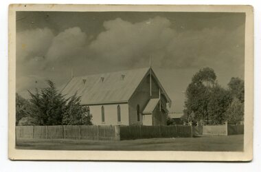
black and white photograph, Empire Post Cards, C 1940s
"The first Presbyterian Church service was conducted at the Orbost Station Homestead in 1885, during a visit by Sir William Clarke, who was accompanied by two ministers. The organist was resident Grace Jennings Carmichael. Services were later held in Mr J. W. Borland’s shop and the Mechanics Hall. In 1887, the land on which the church now stands was purchased from Mr James Hossack snr, for £50 ($100). The trustees were Mr John, Peter and Hugh Cameron, Mr John A Watt and Mr James Hossack Jnr. Timber from Richardson’s Tabbara Mill was used by builder Mr R. P. Cameron and at a cost of £311.3.7 ($622) the church was opened January 9th 1898." (from Newsletter 90 Margaret Smith) In 1928 the Sunday School hall was added to the church. Mr R.P. Cameron was the contractor for both the manse and the church. The first communion service was held on July 17 1892. the Presbyterian Church was commenced in Orbost in 1855 when the Reverend Chas Attwood was settled in pastoral charge.This is a pictorial record of the Presbyterian Church in Orbost as it was in the mid 20th century. It is now the Orbost Uniting Church hall, known as St Andrews Hall,A black /white postcard photograph of the Orbost Presbyterian Church, a wooden structure with a wooden picket fence at the front and trees on right and left sides. on back - " H Gap, Presbyterian Church Orbost"presbyterian-church-orbost religion -
 Orbost & District Historical Society
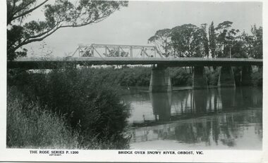
black and white photograph, Rose Stereograph Company, first half 20th century
A new bridge over the Snowy River at Orbost was opened for traffic on June 20th 1922. It was a new timber and steel girder structure, a joint Country Roads Board — Victorian Railways venture and was built and completed at a cost of £41,000 (the steel girders came from the Flinders Street viaduct reconstruction). Subsequently it was decided not to take the railway across the river, and the bridge was only ever used by road traffic. Postcards form a vital part of social and historical records for researchers. This postcard is a pictorial record of an earlier bridge across the Snowy River at Orbost.A black / white postcard photograph of a bridge over the Snowy River at Orbost.0n front - The Rose Series P1200 copyright Bridge Over Snowy River Orbost Vic.snowy-river-bridge -
 Stawell Historical Society Inc
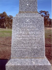
Photograph, “Moray” Grave Marker in a Private Cemetery 1998 -- Coloured
Grave Marker - “Moray” Private Cemetery taken 1998Inscription James Brownstawell -
 Stawell Historical Society Inc
Photograph, “Moray” Grave Marker in a Private Cemetery 2012 -- Coloured
Grave Marker - “Moray” Private Cemetery taken 2012Inscription James Brownstawell -
 Orbost & District Historical Society
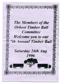
program, Orbost Timber Ball Committee, 1996
This is a program for the 7th Annual Timber Ball held in August 1996. It was sponsored by the Timber Industry.Orbost has historically been based on the timber industry, but that industry has declined considerably over the last 20 years. The number of locals involved in the timber industry has declined and these balls are no longer held. Community balls and dances are becoming rarer as more home entertainment is available and musical tastes have changed. This item is reminiscent of a previous social activity.A pale mauve coloured paper folded in half as a program. Print is black. Front page is framed with a graphical musical frame. Underneath print are images of two timber trucks on either side of a tree. The wording is : "Members of the Orbost Timber Ball Committee welcome you to our 7th Annual Ball Saturday 24 August 1996.' Inside are the names of committee members and sponsors. dancing recreation orbost-timber-industry -
 Charlton Golden Grains Museum Inc
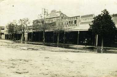
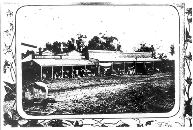
Photograph, Flood 1911, c. 1911
High St Charlton showing W. Wylie General Store, 1911 floodSepia photo of High St Charlton showing W. Wylie General Store and Golden Fleece Hotel after the 1911 flood. Two children standing on footpath with water on the road in front of them.charlton, wylie's building, flood, high street -
 Stawell Historical Society Inc
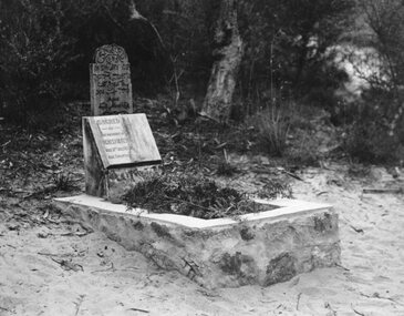
Photograph, Childs Grave with Wooden Marker and marble headstone
Childs Grave with Wooden Marker and marble headstone. Year Not Known.halls gap -
 Eltham District Historical Society Inc
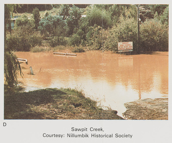
Work on paper (Sub-Item) - Photograph, Sawpit Creek in flood, Diamond Creek Township, 8 April 1977
Colour photograph. Sawpit Creek near the Diamond Creek in flood at Diamond Creek township, 8 April 1977 A road sign reads" DANGER ROAD FLOODED AFTER HEAVY RAIN OBSERVE MARKERS" Nillumbik Historical Society collectionflood, diamond creek, flooding, nillumbik historical society, give way, sawpit creek, campbell street, watkins street, danger, road sign -
 Orbost & District Historical Society
framed black and white photograph, mid - second half 20th century
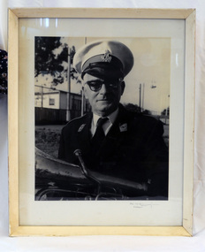
This is a photograph of Mr Clem Heather, band leader. Clem Heather was a Forestry employee in Orbost, The Orbost Workers' Band was started in 1889 by Donald and Archie Munro. The band folded after the town was devastated by floods in 1893. Charles Spink reformed the group in 1905. It split in 1908 and the breakaway band was named the Orbost Workers Band. The two bands, The Orbost Workers and Orbost Town Band would often compete against each other. Eventually, in 1913, the two bands amalgamated to form the Orbost Municipal band. The old Orbost Municipal Band recorded its last meeting in 1941 -a lack of effort and membership. The new Orbost Municipal Band was restarted by Clem Heather (a previous member) on Wednesday 20th September, 1961 and continued into the late 1980s when lack of interest caused it to become defunct.This is a pictorial record associated with the Orbost Brass Band. The various Orbost bands over the years played a major role in community activities providing entertainment and musical experiences for the many membersA black / white photograph of a man in a brass band uniform. He is holding a brass instrument (French horn?). It is under glass in a white wooden frame.on front -????????? Orbostheather-clem orbost-brass-band music recreation -
 Orbost & District Historical Society
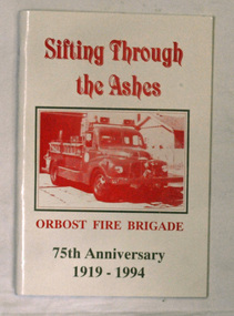
books, Sifting Through The Ashes, 1994
The book was collated by Debbie Hall. Orbost Fire brigade was founded in 1919. The first captain was George Hodgson, assisted by Lieutenant Reg Macalister, Secretary J.F.McCoy and fifteen members. .As there was no fire station the ree l ( a cast off fro m the Bairnsdale Brigade ) w as kep t in the shed at the back of the Council Chambers until the present Station was built in 1922 in its present location in Gladstone Street, Orbost. This book is a written record of the first one hundred years of the Orbost Fire Brigade.Two copies of a paperback book with a white cover and red print. On the cover is a photo of a fire truck in a rectangular frame. The book was produced for the 75th Anniversary of Orbost Fire Brigade 1919-1994. The book contains black and white photographs of Fire brigade activities and extracts from the "Snowy River Mail".In blue pen - "Presented to the Orbost Historical Society from Orbost Fire Brigade - November 12th 1994"book orbost-fire-brigade -
 Orbost & District Historical Society
black and white photograph, Rose Stereograph Company, first half 20th century
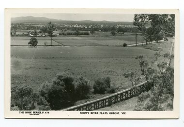
The two bridges on the railway viaduct, which crosses the Snowy River floodplain at Orbost, were built from local Southern Mahogany. The bridge on the Bairnsdale end (770m) is now the longest in Victoria. Despite various attempts to extend the line, the station stayed on the western side of the Snowy River. (info. Helen Martin)This item is associated with the history of the Orbost-Bairnsdale railway line and therefore reflects the role that the rail line played in the social and economic history of Orbost.A black / white photograph / postcard of the Orbost township in the background and the railway viaduct over the flats in the foreground.photo caption - The Rose Series P.479 copywright SNOWY RIVER FLATS, ORBOST, VIC"east-gippsland-railway orbost-viaduct -
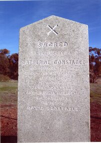 Stawell Historical Society Inc
Photograph, Mrs Catherine Constable nee Moray 1877 -- Restored Grave Marker 2012 -- Coloured
Colour photo of restored Grave Marker - Catherine Constable (Moray) 1877 Restores 2012stawell -
 Orbost & District Historical Society
sprockets and ring gear, 1941
Ron Peck machined the driving sprockets for Bren Gun Carriers which were sent to North Africa. The Rats of Tobruk, the Egypt and Rommell campaign used these munitions. He boarded at Orbost House while doing 12 hour day shifts.During WW11 munitions and defence equipment were manufactured by state government and private engineering firms, co-ordinated by the Commonwealth government. They worked together to meet Australia’s defence needs and create ‘mass production, on a nation-wide scale, of materials and articles of a higher degree of complexity and accuracy than had before been attempted in Australia. These sprockets were manufactured locally.Two metal sprockets for a Bren Gun carrier. One metal ring gear.munitions sprockets bren-gun-carrier peck-james-ronald orbost-motor-works -
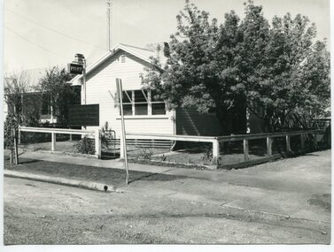 Orbost & District Historical Society
black and white photograph, 1960s - 1970s
This photograph shows the former Orbost Police Station in Wolseley Street before it was demolished and a new larger brick building was built behind it in Lawson Lane - late 1980s.This is a pictorial record of a significant community building no longer existing.A large black / white photograph of the Orbost township police station. It is a weatherboard building surrounded by trees. A sign "POLICE" is hanging from a pole.on back - " Orbost Police Station in Wolseley Street, Donated by Debbie Hall 31/8/94"orbost-police-station -
 Stawell Historical Society Inc
Photograph, Childs Grave with Wooden Marker and Five young Ladies -- Possibly the Folkes Sisters
Childs Grave with Wooden Marker and Five young Ladies. Thought to be the Folkes Sisters. Year Not Known.halls gap -
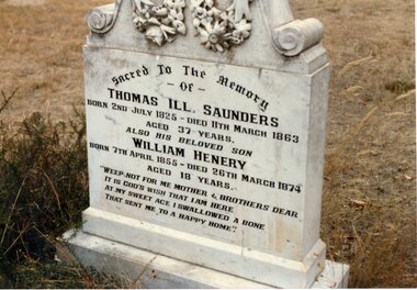 Stawell Historical Society Inc
Photograph, Mr Thomas H L Saunders & Mr William Henry Saunders' Replacement Headstone for the Wooden Grave Marker adestroyed by fire
Replacement headstone for Wooden Grave Marker Thomas H L Saunders destroyed by fire at Stawell Cemeterystawell memorial -
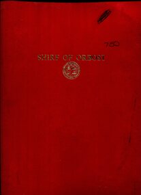 Orbost & District Historical Society
folder of documents, 1970
Councillor J.D. Torley was the chair of this committee. The Bicentenary of James Cook in Australia was commemorated in Australia in 1970. The British explorer Lieutenant (later Captain) James Cook sailed and charted the East Coast of Australia in 1770, and claimed the eastern seaboard of the Continent for the British Crown. This was not considered the official bicentenary of Australia, but rather the mapping of the Eastern coastline.This item reflects the commemoration of a significant event in Australian history.750 is a red coloured plastic folder. The front cover has "SHIRE OF ORBOST" in gold print with the shire seal beneath it. It contains event programs, flyers, booklets, letter heads, souvenir programs, a catalogue for an art contest and minutes of the committee meetings. 750.1 is a manila folder which contains a program and tickets to the 1770 Ball held on Friday 17th April,1970. It also contains letter heads, envelopes and copies of correspondence concerning the Captain Cook 1970 centenary celebrations.cook-james centenary-1970 orbost-shire-council -
 Orbost & District Historical Society
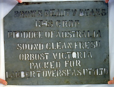
stencil, 1948
This stencil was used to mark bags of dried bean seed, in this case Brown Beauty bean seeds, produced by farmers in the Orbost district and clean and bagged by Fisher Bros., seed bean merchants of Orbost. This stencil is significant because it was specially made for the seed bean industry which was a major industry in the Orbost district for the first half of the 20th century. A galvanised iron sheet from which words have been cut out to form a stencil. BROWN BEAUTY BEANS 1948 CROP PRODUCE OF AUSTRALIA SOUND, CLEAN, FRESH ORBOST, VICTORIA, AUSTRALIA PACKED FOR LAMBERT OVERSEAS PTY LTDseed-beans bag-stencil farming -
 Lakes Entrance Historical Society
Book, Kernot, Maurice Edwin, Bairnsdale-Orbost Rail, 1917
A printout of part of the Paper and Discussion of the construction of the Bairnsdale to Orbost Railway with emphasis on bridges.public utilities, bridges -
 Stawell Historical Society Inc
Photograph, “Moray” Grave Marker in a Private Cemetery 2012 -- Coloured
Grave Marker - “Moray” Private Cemetery taken 2012. Restored by Mr David Constable descendent of David and Catherine Constable.Inscription James Brownstawell -
 Orbost & District Historical Society
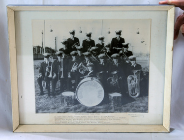
framed photograph, 1965
The first Orbost Brass Band was formed in 1889. Around 1908 the town band split and the Orbost Workers' Band was formed. Eventually the two bands merged in 1913 to reform as the Orbost Municipal Band under conductorship of Charles Spink. The band continued for many years but was later disbanded and again reformed. This was to happen a number of times, the last time being in 1961 and continuing through to the late 1970's. Further info and Ref: In Times Gone By - Deborah Hall The various Orbost bands over the years played a major role in community activities providing entertainment and musical experiences for the many members.A black / white photograph of a group of band members in uniform and holding their instruments. In the front is a young boy holding drum sticks standing in front of a large drum which has ORBOST MUNICIPAL BAND written around its circumference. It is on a white buff card under glass in a white wooden frame.on front - Orbost Municipal Band -1965 with a typed list of names -
 Orbost & District Historical Society
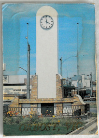
souvenir fridge magnet, C-1980's
Used as a tourist souvenir of Orbost. Possibly made and distributed via the Slab Hut (Orbost Visitor Information Centre) in 1980's/1990's.The souvenir is an important component of the tourist experience with most tourists bringing back mementos and souvenirs as evidence. Fridge magnets are popular as souvenir and promotional items because they are relatively cheap to manufacture and very portable for tourists. This item is an example of a typical souvenir of Orbost.A rectangular shaped flat fridge magnet with a colour photograph of the Orbost War Memorial and the words " ORBOST VIC" on one side. The reverse is a grey/ black flat surface."ORBOST VIC"souvenir frig-magnet -
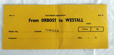 Orbost & District Historical Society
railways envelope, C 1980's
This item was used by Victorian Railways 1970's/1980's. It was used at Orbost Railway Station for the consignment of timber from Orbost to Westall.. Westall was a major timber-receiving depot near Dandenong, Victoria. Westall railway station is located on the Pakenham and Cranbourne lines in Victoria, Australia. It serves the south-eastern Melbourne suburb of Clayton South, opening on 6 February 1951. Westall station was opened as a workers only platform on 16 October 1954. It was provided for the adjacent Martin & King railway coachbuilding factory. The station was opened to the public on 1 June 1959 when all trains on the line began stopping there. The Bairnsdale-Orbost railway was opened in 1916 to serve the agricultural and timber industry. Because of the decline in traffic and heavy operating costs, the line was finally closed in August, 1987. Orbost Railway Station was opened on Monday 10 April 1916 as the terminus of the Orbost railway line, and closed in 1987. The station was located on the west side of the Snowy River despite the town of Orbost being on the east side of the river, in order to save on the costs of a bridge over the river, which at the time had highly variable levels. This item is associated with the history of the Orbost-Bairnsdale railway line and therefore reflects the role that the rail line played in the social and economic history of Orbost.An unused brown/buff coloured goods/freight consignment envelope used by Victorian Railways, this one for timber from Orbost to Westall. It is DL size.2497-78 VICTORIAN RAILWAYS G.F 63 From ORBOST to WESTALL MASS Tonnes kg Vehicle No Contents TIMBER Consignee Date orbost-bairnsdale-railway westall -
 Tarnagulla History Archive
Photograph: Simpsons Store and Hotel, Newbridge after flood, Simpsons Store and Hotel, Newbridge after flood, 1909 (original image)
In this image, store merchandise, including drapery, is hung out to dry after the flood. On 20th August,1909 the Laanecoorie Weir broke away and released 18.3 million cubic metres of water through the opening and causing severe damage to all towns downstream. At Newbridge, Petersen's bakery collapsed and Simpson's Store and Hotel flooded to the roof. The billiard table was later found in a tree five miles down the Loddon near Learmonth. Murray Comrie Collection. Monochrome photograph, image depicting buildings in the area near Loddon River at Newbridge after major flood in 1909. This is a very grainy and dark copy of an older original. Copy probably made by Murray Comrie in the 1960s.newbridge, loddon river, flood, simpson, stores, hotels -
 Charlton Golden Grains Museum Inc
Photograph, Charlton Tribune, 1973 February Flood, Feb 1973
Feb 1973 flood Charlton, Victoria. Old Ive's house with floodwater to front fence on the Calder Highway opposite Charlton Park Gates. Mrs Gloria Jordan.B/W Photograph of February 1973 flood. Old Ive's house with floodwater to front fence on Calder Highway opposite Charlton Park gates. Photo used in Charlton Tribune on 09/07/1973 P4.flood, charlton, calder highway, local brick -
 Orbost & District Historical Society
folder
Orbost Aero Club began in 1969 with Basil Dowie as Chair, David Nixon as Secretary/Treasurer. The group went into recess from 1977-1991 closing in 1997. The mid 1960s were boom years in flying training in Australia and the number of Aero Clubs grew rapidly. The Club played a significant role in the establishment of the small airport at Marlo and in the ongoing operation and development of the airport over the years particularly for patient transfer by aerial ambulance. The Orbost Aero Club Club played a significant role in the establishment of the small airport at Marlo and in the ongoing operation and development of the airport over the years.A buff coloured folder with green cloth spine binding. It contains a copy of the Certificate of Incorporation (18.8.1983) of the Orbost Aero Club. It contains legal documents pertaining to Section 24 of the Companies act 1961. These are carbon copies.On cover - Orbost Aero Club Memorandum of Articles of Association Bottom right corner - Mosley & Palmer Solicitors Orbostorbost-aero-club -
 Orbost & District Historical Society
ledger, 1906
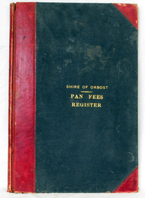
This ledger was used by the Shire of Orbost from 1906 to 1910. The item was donated to Orbost & District Historical society from P.R.O.V. as a Place of Deposit (POD) item for safe keeping by a local history group or museum. The shire covered an area of 9,347 square kilometres and existed from 1892 until 1994 when it became part of the East Gippsland Shire Council. Orbost was at first included in the Bairnsdale Shire from 1882 and was later part of the Tambo Shire. Because of travelling distances the Croajingalong Shire was created in 1892 (name changed to Orbost Shire 17.2.1893 with James Cameron as the first Shire President. In 1994 it amalgamated to become part of East Gippsland Shire Council. In Australian suburbs and rural towns where the sewer wasn't connected, people usually had an outside toilet. The toilet seat was made of a plank of wood secured at its ends to the walls of the building with a large round hole in the middle. Underneath was the removable sanitary pan and on a regular basis, usually weekly, the full pan was taken away and replaced with an empty one. This was the job of the sanitary carter. the sanitary depot was in Martins Lane, Orbost Development of the Orbost Wastewater Treatment Facility began in the 1960’s with the construction of four treatment lagoons. Shortly after the construction of the lagoons the sewerage system was installed throughout Orbost.This item is a record of accounting for the local government. The collection of sanitary pans was a necessary service before the Orbost township was had its own wastewater treatment facility.A large register of pan fees for the Shire of Orbost. A black hard cover book with red binding and marbled end pages. Entries are hand-written in black ink.On spine - "PAN FEES REGISTER: in gold lettering. In centre of front cover in gold - "SHIRE OF ORBOST (underlined) PAN FEES REGISTER"orbost-shire-council ledger-pan-fees sewage orbost-township-sanitary-service -
 Orbost & District Historical Society
black and white photograph, January 1934
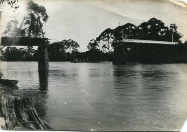
Damage estimated at £500,000 was caused by the 1934 floods in the Orbost district. This 1934 flood was devastating, destroying a section of the 1922 Orbost bridge, wrecking fences, bridges and roads, dumping silt and debris on the rich river flats and drowning cattle. The centre span of the Orbost Bridge was washed away. This item is a pictorial record of the 1934 floods, a significant part of Orbost's history.A black / white photograph showing the flood damage to the Snowy River Bridge. There is a gap in the bridge where the centre span has been washed away. In the background is a punt.orbost-floods-1934 natural-disasters-floods snowy-river-bridge -
 Orbost & District Historical Society
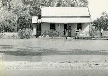
black and white photograph, February, 1971
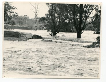
This photograph shows the floodwaters during the 1971 flood at Orbost. The two mahogany trees in the photograph stopped the Snowy River from changing its course. The 1971 flood was the the worst flood on record. At Jarrahmond it was at least 11 metres and up to one and a half kilometres wide on the flats causing enormous damage to the flood plain. Records say that "The brown floodwater stain in Bass Strait could be seen from passing airliners." Considerable damage was done to railway infrastructure, roads and farms. More information from the APRIL, 2008 newsletter by John Phillips. (see orbosthistory.com.au)This is a pictorial record of a significant event in the history of floods in Orbost.A black / white photograph of raging floodwaters at the bottom of the Orbost township.orbost-flood-1971