Showing 439 items
matching flowes
-
 Kiewa Valley Historical Society
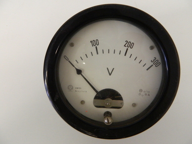
Meter Volt, mid to late 1900's
This analog voltmeter is quite a large (industrial type) apparatus which permits the easy monitoring of electrical variations within the large SEC Victoria Hydro Scheme's electrical generators. These generators are powered by the hydro force of "stored" water at a higher altitude. The establishment of both the NSW and Victorian Hydro schemes was achieved from the mid 1900's to the 1960's. At this point in time the need for additional power sources to quench both an industrial and domestic demand for electricity was purely an economic and not and environmental (carbon reduction) factor. This hydro scheme was instigated by "the Government of the day" as a bold move and was the major force of the World War II refugee and "technical" workforce inclusion of skilled and unskilled migration into the Australian environment. Although this mass "invasion" of workers with families was thought of in some circles as intrusive, the expansion of population post war years and its integration into the Australian rural sector, produced the multi- lingual multi-cultural diversity of later years. This voltmeter is very significant to the Kiewa Valley as its use was introduced during the Kiewa Hydro Scheme. Although only a small apparatus it was part of the explosion of human resources into the valley. This influx of population transformed the region from that of a basically quiet rural region to one which evolved into both an industrial and a larger residential community. This evolution in the valley created a change, not only in the "physical" landscape but also the socio-economic expansion which permitted other "tourist" based industries into the valley. This analog volt meter has two metal rods protruding from the "back" of instrument with screw on points for the negative and the positive leads allowing the "current" to flow across the calibrated resistors to indicate on the "face" side the strength of the voltage "power". The "face" of the instrument has a zero point and then five evenly graduated marks from Zero to the "100, 200 and 300" marked points of measures. A large "V" below these pointers indicates that they represent levels of voltage. Three small screws hold the "face" in place. At the back of the meter is an aluminium "clasp" with three protruding screws (positioning fasteners) and a a screw tightening fixture for the correct fastening of the "clasp" into the correction location on the meter "board".Manufacturer's logo "CSG" underneath "ITALIA"kiewa valley tourism, victorian alps, alternate energy supplies, alpine population growth -
 Federation University Art Collection
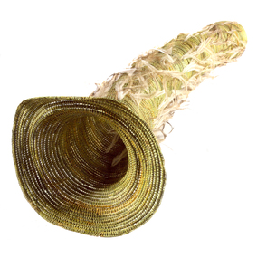
Artwork, other, 'Eel Trap with Emu Feathers' by Bronwyn Razem, 2013
"The breeze going through the eel trap gives a feeling of water flowing through the vessel with the feathers softly waiving as the water flows. My grandfather Nicholas Couzens and my uncles made eel traps to fish the Hopkins River - this is how my mother learnt the techniques which she passed on to me."Bronwyn RAZEM Gunditjmara/Kirrae Whurrong Bronwyn Razem is an Indigenous Australian basket weaver and painter. She is a Gunditjmara woman of the Kirrae Whurrong clan of western Warrnambool on the Victorian coastline. Bronwyn’s practice involves an exploration of her Indigenous heritage and identity, and she creates symbolic representations of places and events that are meaningful to her family. She integrates ochres, sand and other materials into her paintings, and her works also draw on the possum skin cloak traditions of her ancestors. In 2008, Bronwyn was chosen by the Australia Council for the Arts to be part of a delegation of Indigenous artists to attend the 10th Pacific Arts Festival in Western Samoa. Bronwyn’s mother, Aunty Zelda Couzens, was a well-respected basket weaver and elder who taught Bronwyn basket-making techniques. Bronwyn now regularly conducts basket weaving workshops with Victorian Indigenous communities in order to facilitate the revival of cultural traditions. She has a Bachelor of Arts with Honours at Deakin University, and in 2008 she was enrolled in a Master by Research degree at Deakin Institute of Koorie Education, Geelong, and was living in Ballarat. (https://www.daao.org.au/bio/bronwyn-razem/biography/, accessed 18 April 2016) This item is part of the Federation University Art Collection. The Art Collection features over 1000 works and was listed as a 'Ballarat Treasure' in 2007.Bronwyn RAZEM (1953- ) Gunditjmara/Kirraw Wurrong A woven New Zealand flax eel trap with emu feathers. This work won the University of Ballarat Acquisitive Award for work reflecting Victoria's Western District. The judges were impressed by Bronwyn Razem's translation of the traditional eel trap into a sculptural form evocative of the flow of water and possible the passage of time. The design and technical knowhow which Razem inherited from her mother, uncles, and grandfather connects this work to the family;s life and traditions. She then enhances the simplicity of this very functional object by the addition of delicate emu feathers, creating a work that creatively and symbolically transcends its original form. art, artwork, bronwyn razem, razem, eel trap, aboriginal, indigenous, available -
 Geoffrey Kaye Museum of Anaesthetic History
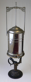
Equipment - Nitrous oxide gasometer, Buffalo Dental Manufacturing Company, 1876-1901
The main component of the nitrous oxide gasometer is a reflective white metal urn-shaped chamber from which an outlet valve and circular moulded tap allows for the flow of gas. A rectangular frame sits atop the chamber and comprises ornately decorated metal flourishes and three white metal anchoring pipes, two attached to each side of the chamber and one attached to the centre of the two-tiered, domed lid. The gasometer sits atop a Y-shaped cast iron stand, ornately decorated with metallic golden brass paint, with a circular base. There is also a black cast iron ring that is attached to the stand. Manufactured by Buffalo Dental Manufacturing Company, Buffalo NY.Inscription on base. "B.D.M. CO, BUFFALO N.Y." Inscription on vertical. "1 2 3" Inscription on upper side of top ring. "J. DEMAREST//PAT.FEB.15.1876." Inscription on lower side of top ring. "15"gasometer, nitrous oxide, storage, anaesthesia, dentistry, chloroform, ether, b.d.m. co -
 The Beechworth Burke Museum
Photograph, c1960
The date this photograph was taken is unknown. Estimated date 1960-70s. The gentleman in the photograph and location the photograph was taken are also unknown. Perhaps in the Beechworth or Stanley area. Unknown what the photo is referencing, however, there is perhaps an old wooden pump house near a large body of water. Located inside the pump house is an old rusted steam engine, dated c1900, which could have controlled the flow of water. The photo is associated to another record, 6856 as it has the same elderly gentlemen in the image. He is able to be identified through wearing the same clothes and distinctive hat in both photographs. The photograph could be associated to mining as the gentleman is standing next to a small mine site in a related record. Colour rectangular photograph printed on glossy photographic paper. Obverse: Reverse: 6857/ colour photograph, beechworth, burke museum, mining, miners, stanley -
 Royal Australian and New Zealand College of Obstetricians & Gynaecologists (RANZCOG)
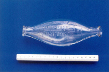
Infant feeding bottle, Mellin's, Mellin's Food, c. 1900 to 1940
Feeding bottles of this shape were on sale from 1900 for about 40 years. The Allenbury feeder devised by Allen & Hanburys, U.K. was the first of this type. They were easier to clean and the mild flow was easier to regulate. Source: Kevill-Davies, Sally. "Yesterday's Children: The Antiques and History of Childcare" Mellin's Food was a company which produced patent milk solids and cereal preparations from c1860s. English food chemist Gustav Mellin developed an infant food formula in the late 1860s, dubbed Mellin's Food, which became the most widely used mass produced food at this time. Source: Andrew Smith (2013). "Baby Food". The Oxford Encyclopedia of Food and Drink in America. ISBN 9780199734962. Glass feeding bottle. Bottle is loosely boat shaped with flat base, and neck and openings at either end. There is a small flattened area on the base to allow the bottle to balance. Writing embossed into bottle reads 'MELLIN'S FOOD' and 'TABLE SPOONS'. Graduated markings for months of age and tablespoons. Visible join seams on bottle.infant feeding, infant care -
 National Communication Museum
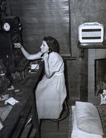
Photograph (item), Miss H.C. Felton, Postmistress, Tintaldra, March 1952
During the North-East Victorian bushfires of 1952, Helen Felton, Postmistress of Tintaldra post office, worked continuously for five days and nights to ensure the flow of communication through the disaster. Helen Felton conceded to leave her post for only 45 minutes while “the fire passed within fifteen feet of the spot where she was working,” burning down the garage and neighbouring store, before returning to work. Today, technologies such as cells on wheels, mobile exchanges on wheels, and NBN Sky Muster trucks are deployed in the wake of a disaster to ensure survivors have access to communications services. In a disaster, access to mobile coverage or landline connection to emergency services can be essential for the survival of life and property.emergency, bushfires, communications, regional, post office, telephonist, postmistress, helen felton -
 Bendigo Historical Society Inc.
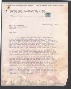
Document - BILL ASHMAN COLLECTION: CORRESPONDENCE
Letter, dated 2 February, 1954, from Roy Michaelis to Mr. F. A. Stevenson. Letter typed on paper with printed letterhead. In the letter the writer mentions that he has a pipe line which has fouled up and he was inquiring if a scalebuoy would improve the problem. The second letter ( a carbon copy), dated 10/2/54, is to Mr Roy Michaelis from (name obscured). He mentions that he has thought about it but he can't see any way to help at the moment. He also says that the scalebuoy needs a steady flow of water which the hydraulic ram does not give. He also refers to some other work he has done elsewhere.sciences, instruments - general, scalebuoy, bill ashman collection - correspondence, michaelis hallenstein & co pty ltd, f a stevenson, roy michaelis -
 Kew Historical Society Inc
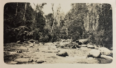
Photograph - Strickland Spur track, c.1926
Henry Beater Christian (1886-1962) , was a descendant of one of the earliest settler families in Kew. Employed at the Kew Asylum as a 'public servant', he was a skilled amateur photographer, photographing numerous scenes in Kew and on his travels around Victoria. The majority of his photographs date from 1916 to 1929. His finest photographs are housed in two photograph albums. Digital copy of a photograph from page 18 of the 47-page photograph album containing 261 gelatinous silver images, loaned by Diane Washfold with permission given to digitise and hold a copy in our collection. This photograph, dating from c.1926, forms part of a group of photos of the Strickland Spur track, taken on a bushwalking trip to Marysville, Victoria. John Chapman has written in 'Bushwalking Clubs - A Brief History', about the establishment in Victoria of the first bushwalking club in 1888, and the popularisation of bushwalking during the interwar period. The photograph shows either the Steavenson or Taggerty River near Marysville. The photographer contrasts the rapid flow of the water through the rapids with the stillness of the surrounding tree ferns and trees."Spur" [illegible ink inscription]henry beater christian (1886-1962), landscape photography, kew (vic.) — yarra river, christian-washfold collection, photograph albums, bushwalking -- victoria, strickland spur -
 Wodonga & District Historical Society Inc
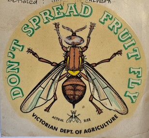
Document - Fruit Fly Border Express Pass, De Neefe Signs Pty. Ltd, c1960
The permanent fruit fly road blocks in Victoria began in 1958. The first was set up on the Lincoln Causeway between Albury and Wodonga. The aim was to protect the Victorian fruit export industry, the largest in the country. Cars would be stopped and inspected when entering Victoria. At peaks periods, such as Easter and school holidays, there were up to 10 inspectors at the 24 hour checkpoint near the former butter factory on the Lincoln Causeway. Local residents could apply for a pass such as this one which would be displayed on their window, but were still subject to random checks. Hundreds of tonnes of fruit each week was confiscated and pulverised by Department of Agriculture staff. The road block was closed in 1980, partly due to the increased traffic flows and the cost of maintaining inspection points.This image reflects government measures taken to protect the fruit industry in Victoria.A transparent sticker designed to be applied to a car window for motorists to pass through Department of Agriculture fruit fly control points. Instructions for applying the sticker to the window are written on the back of the sticker. It features a large coloured image of a fruit fly as well as a smaller life sized representation of a fruit fly.Around the edge of the circle: "DON'T SPREAD FRUIT FLY/ VICTORIAN DEPT. OF AGRICULTURE? Beside small fruit fly image: "Actual Size"fruit fly control, department of agriculture, fruit fly pass -
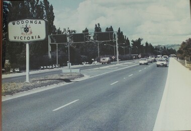 Wodonga & District Historical Society Inc
Photograph - Wodonga, Victoria sign and the Fruit Fly check point c1970s
The permanent fruit fly road blocks in Victoria began in 1958. The first was set up on the Lincoln Causeway between Albury and Wodonga. The aim was to protect the Victorian fruit export industry, the largest in the country. Cars would be stopped and inspected when entering Victoria. At peaks periods, such as Easter and school holidays, there were up to 10 inspectors at the 24 hour checkpoint near the former butter factory on the Lincoln Causeway. Local residents could apply for a pass which would be displayed on their window, but were still subject to random checks. Hundreds of tonnes of fruit each week was confiscated and pulverised by Department of Agriculture staff. The road block was closed in 1980, partly due to the increased traffic flows and the cost of maintaining inspection points.This image reflects government measures taken to protect the fruit industry in Victoria.A large image of the LIncoln Causeway at the Victorian/NSW border at Wodonga. The southbound lanes on the right hand side feature overhead signals and traffic light signs to control traffic leading into the Fruit fly inspection checkpoint ahead. The photo is in a wooden frame.On right hand side: Border sign: Wodonga/Victoria and the Victorian State Coat of Arms.fruit fly control, victoria border, lincoln causeway wodonga -
 Geoffrey Kaye Museum of Anaesthetic History
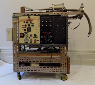
Machine - Waveform Ventilator, 1970
Professor Arthur Barrington (Barry) Baker was the first Australian anaesthetist to gain a DPhil in anaesthesia. He completed his DPhil at Oxford University at the Nuffield Department of Anesthesia in 1971, titled, Physiological Responses to Artificial Ventilation. The Waveform Ventilator is the machine developed to illustrate his DPhil. The waveform ventilator was used in several scientific studies on 'the effects of varying inspiratory flow waveforms and time in intermittent positive pressure ventilation (IPPV)', published in the 'British Journal of Anaesthesia'. Professor Arthur Barrington Baker had an extensive career in research and clinical practice including holding the position as the Nuffield Professor of Anaesthetics at Sydney university (1992 - 2005) and also as the Dean of the Australian and New Zealand College of Anaesthetists (ANZCA) (1987-1990).The variable waveform ventilator is of national significance, due to its association with Professor Arthur Barrington Baker (Prof. Baker) the first Australian academic anaesthetist, and the representation of historical social themes and research and design, in anaesthesia. Historic significance – It is a rare type of ventilator in good condition and well provenanced. It is a tangible record of the beginning of the long established and distinguished career of Prof. Baker, the first anaesthetist in Australia to gain a DPhil. Prof Baker has a strong involvement in the Australian and New Zealand College of Anaesthetists (ANZCA) organisation. The object is a product of Prof Baker’s Doctorate of Philosophy (DPhil) on respiratory physiology and is associated with the prestigious Oxford University and the well-known Nuffield Department of Anaesthetics. It also represents the social theme of migration to England from Australia in the 1960s and 1970s to access and experience academic and artistic opportunities limited in Australia at the time. Scientific Value – The object is of scientific value as it offers major potential for education and interpretation in anaesthesia. Although ventilators are common equipment, this specific design and construct prototype is one of a kind, designed and used specifically for research purposes. A rectangular shaped object on a trolley with four wheels. The top half of the object consists of two panels, one of cream coloured painted wood, the other black plastic, both containing several dials of different shapes and sizes. The wood surface also contains several gauges and a safety pressure clear plastic box. The plastic surface also contains a pin board. The bottom half of the object consists of two shelves. The whole object's perimeter is lined with perforated metals. The top wooden surface has several metal pieces of equipment and a long tube. The rear of the object contains numerous types of tubing and wire, a gas cylinder and two leather straps with buckles. The bottom half of one side of the objects has 3 electrical power outlets.Waveform Generator, Drs Colliss N Cowie, Dr Baker Dr Murray Willson, Dr Babbington, Safety Pressure, Error POS F/B, Position, Feedback, Set Balance, Reset, Full Stroke, Velocity, Converter Current, line Pressure, Low Pressure, Bias Pressure, Start, Stop, Stop, Reset Press, Max Press, W/G Output, A/CRO B/2.baker, arthur barrington, baker, barry, professor, academic anaesthetist, oxford university, nuffield department of anaesthesia -
 Federation University Historical Collection
Tool - Object, E. Thomas & Williams Limited, Cambrian Lampworks, Kop Staszic Carbide Lamp
Carbide lamps, or acetylene gas lamps, are simple lamps that produce and burn acetylene (C2H2) which is created by the reaction of calcium carbide (CaC2) with water. Acetylene gas lamps were used to illuminate buildings, as lighthouse beacons, and as headlights on motor-cars and bicycles. Portable acetylene gas lamps, worn on the hat or carried by hand, were widely used in mining in the early twentieth century. A mining or caving lamp has calcium carbide placed in a lower chamber, the generator. The upper reservoir is then filled with water. A threaded valve or other mechanism is used to control the rate at which the water is allowed to drip into the chamber containing the calcium carbide. By controlling the rate of water flow, the production of acetylene gas is controlled. This, in turn, controls the flow rate of the gas and the size of the flame at the burner, and thus the amount of light it produces. Staszic is a coal mine located in Katowice , in the district Giszowiec, Poland This type of lamp generally has a reflector behind the flame to help project the light forward. An acetylene gas powered lamp produces a bright, broad light. Many cavers prefer this type of unfocused light as it improves peripheral vision in the complete dark. The reaction of carbide with water produces a fair amount of heat independent of the flame. In cold caves, carbide lamp users can use this heat to help stave off hypothermia. When all of the carbide in a lamp has been reacted, the carbide chamber contains a wet paste of slaked lime (calcium hydroxide). This is emptied into a waste bag and the chamber can be refilled. (http://en.wikipedia.org/wiki/Carbide_lamp, accessed 06/05/2015)Metal Carbide Mining lamp with light reflector and hook.miners lamp, mining lamp, statszic, poland, carbide, mining -
 Royal Australian and New Zealand College of Obstetricians & Gynaecologists (RANZCOG)
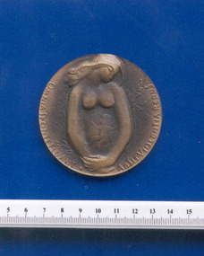
Commemorative Alfred Kotasek medal associated with Frank Forster, 1974, 1974 (approximate)
According to a typed note with the object, this medal came from Czechoslovakia in 1974. It belonged to Frank Forster. Alfred Kotasek (1911-1991) was a Czech professor of obstetrics and gynaecology. The date featured on this medal is the date of his birth, and 'MUDr' is a Master of General Medicine qualification. The Latin motto featured on this medal is strongly associated with the 17th century Czech (Moravian) author and pedagogue Jan Amos Komensky, who allegedly took this phrase as his motto and featured it in one of his most famous works, 'Orbis sensualium pictus' (The World in Pictures) [1658]. Loosely translated, the meaning of the motto approximates 'Let everything flow freely, without violence to things.' 'Orbis sensualium pictus' has been described as the first true illustrated book for children, and Komensky is considered by some to be the father of modern education.Round bronze coloured medallion. Front of medal features a profile portrait of Professor Alfred Kotasek and is inscribed "19.12.1911/PROF.MUDR/ALFRED/KOTASEK". Back of medal features a raised image of a woman with a child in utero and is inscribed "OMNIA SPONTE FLUANT ABSIT VIOLENTIA REBUS".numismatics -
 Otway Districts Historical Society
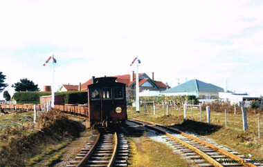
Photograph, Langford, Weston, Goods train arriving at Beech Forest, 1961, 9 August 1961
From late in 1960 VR took what were the first definite steps to close the Colac-Beech Forest line. 1,101 tonnes of freight per year flowed from Colac to Beech Forest because of increasing competition from the roads. From 1 July 1960 onwards, when pulpwood (hardwood) stopped being shipped from Beech Forest, a maximum of only 7,000 tonnes/year would be shipped to Colac. Including special trips passenger revenue earned a little more than $200 per annum. The issue of second-hand sleepers stopped entirely and the two track gangs only patrolled the track and tightened loose bolts. The line did not earn its way and on 4 November 1960 it was recommended that services over the narrow gauge line be discontinued.The rear of a goods train from Colac arrives at Beech Forest on 9 August 1961. The other line is the former Crowes line truncated at Weeaproinah in January 1955. In the background is the Beech Forest Hall and Shire of Otway offices. Colour.colac; beech forest; railway; -
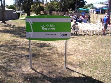 Sunbury Family History and Heritage Society Inc.
Photograph, Leo O'Brien Reserve, November 2015
The sign was erected in the reserve in November 2015. Leo O'Brien was a long time Sunbury resident and the son of Terence O'Brien, who farmed in the district. The reserve is on a section of land that Leo owned, which fronted Barkly Street to the west and Jackson Street to the east. As Sunbury developed the higher section of the property was subdivided for housing and today Terence Street is in that subdivision. The Leo O'Brien Reserve area could not be developed for housing because that land is part of the former main drain, which was a natural waterway that flowed through a part of Sunbury an entered Jacksons Creek at the end of Brook Street. Today the open drain is covered over. Terrence O'Brien served as Shire President on Shire of Bulla Council during the first two decades of the twentieth century and was also a member of the Sunbury Waterworks Trust from 1913 - 1914.A coloured photograph of sign placed at the entrance of a small open space. Tables and chairs have been set out for refreshments in the reserve.leo o'brien, leo o'brien reserve, terence o'brien -
 Falls Creek Historical Society
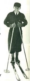
Equipment - Martin Romuld's Skis
Martin Romuld was born near Trondheim in Norway on September 26, 1905. He started jumping on skis at age 6 or 7 and became very good at it. He completed his degree in Civil Engineering at the University of Trondheim and decided to come to Australia. He arrived on 7 March 1928 and found a job with the SEC. The SEC wanted to investigate the possibility of a hydrological surveys necessary to determine the flow of water over a period of years. These surveys started in 1934 and continued until 1941. He lived at Wilkinson’s hut for most of the time during those years both in summer and winter. In his role with the SEC, Martin visited all the various creeks to measure water flow rates as often as was necessary. These skis were used on his winter rounds during the time he spent in the area. Martin also competed in skiing during the 1930s. He won the combined Australian title 3 or 4 times. He was unbeatable in cross country, probably due to the continual practice in his job. Before migrating to Australia, Martin had been runner up in the 1926 European Jump Championships held in France. Jumping was his favourite thrill and he would often construct a jump for practice near the Scout Hut (or Rover Chalet) quite near to Wilkinson’s. In 1941 Martin joined the Royal Australian Air Force and after the War skied mainly at Mt Buller. He maintained his involvement in competitive skiing as an official. In 1958 Martin was the main judge of the National jump which was held to the left of the Nissen tow. He also designed the jumping course at the Donna Buang snow fields. Martin Romuld was Co Vice-President of the Federation of Victorian Ski Clubs in 1949, along with Tom Mitchell M.L.A. Martin Romuld died on 14 July 1998 in Prahran, Victoria,These skis are significant because they belonged to a pioneer of Falls Creek and the sport of skiing in Australia.A set of skis made for Martin Romuld. They are made from American hickory which arrived in Australia via Norway in October 1933. Andy Broad made the skis and they were furnished with steel edges. There was enough hickory for 18 pairs of skis and a pair of competition cross country skis were also made for Martin Romuld. martin romuld', falls creek pioneers, australian skiing history -
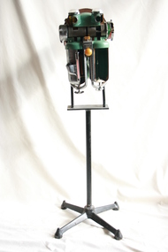
 Department of Energy, Environment and Climate Action
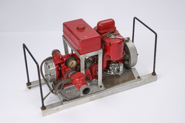
Pacific Marine pump Type Y
The Pacific Marine company was based in Seattle on the west coast of America and manufactured its first satisfactory portable fire pump 1925. These early Type N pumps were replaced in 1933 by the more familiar Type Y pumps. The updated pumps proved popular with the US Forest Service, and a large number were purchased by the Forests Commission as part of the equipment upgrade program in the wake of the 1939 bushfires. The Pacific Marine had a 9.8 Hp, two-cylinder, two-stroke petrol motor running with a high oil mix ratio of 16:1, so it blew vast clouds of blue smoke as the motor screamed at 4500 rpm. Part of its unique design was the water-cooled engine and muffler. But if the flow of water was interrupted the engine would quickly overheat and seize, so it needed constant monitoring and attention. Water was driven through a pair of bronze impeller gears which also needed a constant flow of water otherwise they would also self-destruct. When running properly, a Pacific Marine could pump 63 US gallons per minute, or about enough to fill a 200-litre drum. But its main feature was its high pressure of up to 225 psi. Pacific Marine pumps were often mounted on top of departmental fire tankers and used to spray water into the tops of burning trees. Compared to other pumps of the era it was light weight at only 70 pounds and was often mounted on a wooden stretcher frame. But they were cantankerous things to start with the rope pull and many exasperated novices came away with skinned knuckles. Modern Honda motors, which were more reliable and smoother running, replaced the Pacific Marines as the pump of choice for forest firefighters in the 1980s.High pressure Pacific marine Pumpforests commission victoria (fcv), bushfire, fire pump -
 Federation University Historical Collection
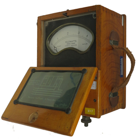
Instrument - Electrical Instrument, Everett AC Wattmeter, 1923
Would have been used by staff and students of electrical Engineering at the School of Mines, Lydiard St. campus up until the start of the Mount Helen campus E building third floor. The meter would have had limited use in classes until 2009. This Wattmeter became part of the historical collection in 2011 after the movement of Engineering out of the E building. In working condition and a good example of early 20th century electrical instruments.A polished natural timber case with partial flip top lid and leather carry handle, housing a single phase AC Wattmeter, rated at 170 volts , 30 amps Scale 0 to 5 kilowatt. Serial no :210088Schematic diagram on inside lid showing how to connect the Wattmeter to measure a 3 phase balanced load. Paper sticker on top "1/92" Information for voltage and current ranges painted with white paint on left hand side by Voltage terminals Voltage terminals labelled A and N Also white on black "W8" on same surface Aluminium plate "67" on right hand side near current terminals which are engraved To A and Ti A to indicate current flow direction Aluminium sticker with Ballarat CAE Electrical Engineering by carry handleeverett instruments, single phase, wattmeter, electrical, scientific instruments -
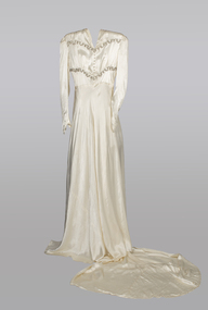 Warrnambool and District Historical Society Inc.
Textile - Wedding dress, Miss Hedrick's dress Shop, 1940's
Through the address on the box, this dress has a local connection. Miss Mavis Hedrick operated a dress salon at 162 Liebig St Warrnambool in the 1940's. Her parents lived at various houses in Warrnambool, including Skene, Spence and Princess Sts. She married John William Freeman in 1942 and left Warrnambool some time after that date. From wedding reports of the day it doesn't seem that this is Miss Hedrick's wedding dress. It seems more likely that it was purchased from her frock salon in Liebig St Warrnambool.While the owner and original wearer of this dress has eluded us, the dress has a strong link to Warrnambool through the original box with its identifying labels. The dress is very much in the style of the era of Miss Hedrick's dress shop..This cream silk wedding dress and slip was donated in original cardboard box with the address written in large letters on the front. The dress is cream silk with gold metallic trim in two lines across the bodice.There are silk covered buttons on the front and back of the bodice and it has a high rounded V neckline.It has long lily point sleeves .There is a side opening with hook and eye fastening.The skirt is cut on the cross and a small train flows from the back of the dress. A simple A line slip accompanies the dress. It has ribbon shoulder straps and the top is edged in a fine narrow lace. The large box is rectangular and grey in colour. The addressee's name is written in large lettering in black (possibly crayon) . A label is pasted to the top right hand corner. A Victorian Railways stamp is loose with the item.On the Box : Miss Hedrick Frock Salon Warrnambool On Label in top RH corner: Mollard & Williams 238 Flinders Lane Melbourne. Stamp: Victorian Railways Parcel stamp 8d Melbournewarrnambool, 1940's wedding dress, mavis hedrick, mollard and williams, 238 flinders lane melbourne, miss hedricks frock salon -
 Bendigo Historical Society Inc.
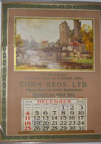
Domestic Object - COHN BROTHERS COLLECTION: CALENDAR FOR DECEMBER, 1938
Cohn Brother's Calendar for December 1938. The Calendar features a painting by the French artist Maurice Levis featuring a painting of a French river flowing through a large castle town, on the left side there is a family of three about to push their boat into the river.. Below the painting has the following text along with the December Calendar itself "Where Life Flows Gently on Its Way From Painting by Maurice Levis For All Ocasionals 6 0'CLOCK LAGER and 7 0'CLOCK STOUT COHN BROS. LTD. Aerated Water and Cordial Manufacturers BENDIGO and SWAN HILL. The Calendar itself also has dates left behind by its first owner such as the anniversary of his Father's death on the 1st and two other dates on the 19th and 20th that are slightly difficult to read.bendigo, history, cohn brothers, cohn brothers, france, maurice levis -
 Bendigo Historical Society Inc.
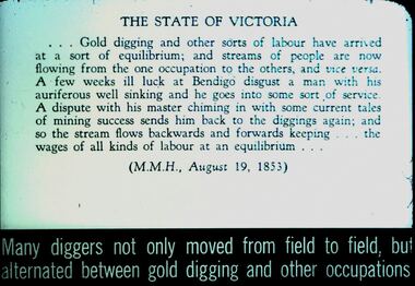
Slide - DIGGERS & MINING. DIGGERS AND MINERS, c1953
Diggers & Mining. Diggers and miners. Many diggers not only moved from field to field, but alternated between gold digging and other occupations. Slide; THE STATE OF VICTORIA - - - Gold digging and other sorts of labour have arrived at a sort of equilibrium; and streams of people are now flowing from the one occupation to the others, and visa versa. A few weeks ill luck at Bendigo disgust a man with his auriferous well sinking and he goes into some sort of service. A dispute with his master chiming in with some current takes of mining success sends him back to the diggings again; and so the stream flows backwards and forwards keeping - - - the wages of all kinds of labour at an equilibrium - - - (M.M.H., August 19, 1853) Markings: 46 994:LIF I. Used as a teaching aid.hanimounteducation, tertiary, goldfields -
 Geoffrey Kaye Museum of Anaesthetic History
Machine - Coxeter-Mushin carbon dioxide absorber MK II, sectioned, c. 1945
The Coxeter-Mushin carbon dioxide absorber consists of the main metal body, painted aquamarine, fixed to a stand. The cylindrical silver metal cannister on the left was used to contain ether, while that on the right contained soda lime. The apparatus has been sectioned to show the inside of the two cannisters, the right of which has an arrow drawn inside to indicate the flow of air breathed out by a patient. The front cover over the control dials has also been removed to show the mechanism. The two circular holes above the dials, facing forward, are where two corrugated tubes would attach; both of these tubes attached to the mask of the patient. The round yellow knob in the centre controls the Compensating Valve, which allowed the anaesthetist to raise or lower the rebreathing bag to allow air into the circuit or expel anaesthetic gas.anaesthesia, carbon dioxide, ether, soda lime -
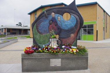 Federation University Historical Collection
Photograph - Photograph - Colour, Churchill Service Memorial, 2015, 2015
In recognition of its fallen soldiers and Churchill's 50th birthday a service memorial was erected on a concrete plinth at the Churchill town plaza and used for the first time to mark the ANZAC centenary on Anzac Day 2015. Churchill never had a war memorial and received a grant from the Department of Veterans' Affairs six years ago to commission a sculpture with Latrobe City Council's support. It was decided the sculpture needed to recognise more than just the war effort, but service and volunteerism, considering Churchill was only founded in 1965. (http://www.latrobevalleyexpress.com.au/story/2816903/churchills-new-memorial/, accessed 01 may 2015) Sculptor Paul Jesse discussed the work in Churchill and District Community news, 18 December 2014: Some time ago CDCA commissioned a sculpture to be used as a Service Memorial to commemorate the fallen that have died in service of our community and country. Traditional memorials usually commemorate Armed Services personnel, but CDCA was of the opinion that a more inclusive view which included Emergency Services personnel, such as CFA, SES and Police, could be incorporated into the Churchill Memorial. Boolarra artist, Paul Jesse, who is accomplished in Ferro-Cement sculpture techniques, was commissioned to create a memorial that would cause people to reflect on the meaning of ‘service’ and ‘sacrifice’. The following is a description of the Churchill Service Memorial Sculpture written by the sculptor, Paul Jesse. “My sculpture is different from most War Memorial sculptures because it uses as its basis the reasons why people go into service or to war. One side of the sculpture is colourful and optimistic; its theme is home, family, community and the future. These themes are crafted by flow lines which are connected to the other side of the sculpture through the round hole and the Crosspiece. These lines can be seen as a multi-layered connection between the sides. On the “dark” side of the sculpture, the lines begin with a spiral of coloured mosaics. This spiral is representative of our service people. Its beginning can be seen on one level as their soul. The spiralling mosaics of them flow to the other side of the sculpture where they create the landscape and figures. These lines can also be seen as a range of connectors between the two sides, representing a flow of thoughts, love, fear, concern and dreams. They also represent physical communication such as letters and phone calls.” This ‘Service Memorial’ is located in the Churchill Plaza (adjacent to the Town Hall), along with four flagpoles, seating and garden beds. The Churchill Service Memorial has deliberately been designed as a thought-provoking public art work. It will complement the Art and Culture Pathway which links Switchback Gallery at the Federation University Campus to the Town Centre. We hope Churchill citizens will pause to view the Memorial, ponder its meaning, reflect on the service of others and commemorate the fallen. Colour photograph on an abstract Australia-shaped sculpture by Boolarra artist Paul Jesse. The abstract Australia-shaped sculpture is in stark contrast to the bronze-cast "fallen mate" or concrete cenotaph seen in many country towns. The photograph includes wreaths from the ANZAC centenary service on ANZAC Day 2015. churchill, churchill war memorial, paul jessie, anzac centenary, federation university, gippsland, art and culture pathway, world war -
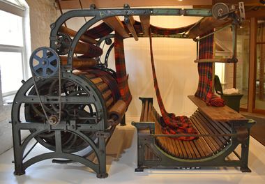 National Wool Museum
Machine - Teasel Gig, c1890
When the fabric is removed from the loom it is often stiff, rough and uneven. There are a number of finishing processes, both mechanical and chemical that give wool fabrics their special look and feel. The fabric is often scoured again to remove oils and dirt picked up during manufacture. It is then pressed. For a soft and fluffy surface, the fabric is brushed. For a smooth surface, it is shorn. For centuries, machines similar to this teasle gig were used to finish fabrics. It uses the prickly flower head off the teasle plant (Dispsacus Fullonum) to do the delicate work to raise the surface, or nap, the woollen cloth. At least 1,500 teasle heads are needed for one gig. The teasel is a thistle like plant whose dried heads are used on the teasel gig. They are fixed to frames around the drum, or gig. The gig turns in the opposite direction to the flow of the cloth until the nap is raised. Also spelled as Teazel Gig.Large metal machine with wooden rollers and teasel covered drum.textile finishing, raising, raising machinery, teasel gig, fabric, wool processing, plants, thistle, drum -
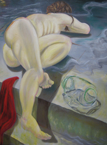 Federation University Art Collection
Artwork, 'Cassandra After the Fact' by Andrew Potter, 2009
This work pays homage to Solomon J. Solomon’s Ajax and Cassandra. Andrew Potter’s painting tells of the subsequent event. Cassandra is undoubtedly a Trojan War casualty, symbolizing the personal pain of widows and rape victims. The flow of the fabric is the allegory of bloodshed, while the empty jar suggests displacement of refugees. Cassandra’s body, as mother earth, is a metaphor for the peaceful landscape that is desecrated by acts of war. The artist uses these iconic figures to exemplify and demonstrate why peace is always better than war. This work was awarded second prize in the 2009 Lucato Peace Prize. During that year Andrew Potter was undertaking the first year of a Bachelor of Visual Arts (Fine Arts) at the University of Ballarat’s Arts Academy. This item was runner up in the Lucato Peace Prize, and is part of the Federation University Art Collection. The Art Collection features over 1000 works and was listed as a 'Ballarat Treasure' in 2007.Painted canvas depicting a naked woman lying on the round beside a glass jar.art, artwork, andrew potter, potter, lucato peace prize, mythology, available -
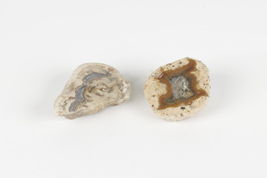 The Beechworth Burke Museum
Geological specimen - Thunderegg agates, Unknown
Thunderegg Agates are formed within rhyolite volcanic ash layers. They are rough spherical shapes, varying in size from less than an inch to over a metre long. Thundereggs usually contain centres of chalcedony which may have been fractured followed by deposition of agate, jasper or opal, either uniquely or in combination. A unique characteristic that these specimens have is the fact that they often look like ordinary rocks on the outside, but slicing them in half and polishing them may reveal intricate patterns and colours. These particular specimens are examples of thunderegg agates. Agate is a variety of chalcedony, a cryptocrystalline form of quartz. The agate component contributes to the intriguing internal patterns of the specimens. The specific locality of these specimens is unknown but they can be found in flows of rhyolite lava. They are formed in gas pockets in the lava, which act as moulds. These specimens can be found globally, with specific locations in Germany being particularly abundant. This specimen is part of a larger collection of geological and mineral specimens collected from around Australia (and some parts of the world) and donated to the Burke Museum between 1868-1880. A large percentage of these specimens were collected in Victoria as part of the Geological Survey of Victoria that begun in 1852 (in response to the Gold Rush) to study and map the geology of Victoria. Collecting geological specimens was an important part of mapping and understanding the scientific makeup of the earth. Many of these specimens were sent to research and collecting organisations across Australia, including the Burke Museum, to educate and encourage further study.Two small solid specimens with pale, sandy-coloured exteriors and fractured internal patterns. burke museum, beechworth, geological, geological specimen, thundereggs, thundereggs agate, agate, rhyolite, rhyolite lava, volcanic ash, chalcedony, cryptocrystalline -
 Wodonga & District Historical Society Inc
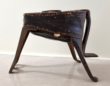
Functional object - Foot Bellows, Fletcher Russell & Co. Ltd, c1895
FLETCHER RUSSELL & CO. LTD/ WARRINGTON MANCHESTER & LONDON Thomas Fletcher (1840-1903) had established a gas appliance manufactory in Thynne Street, Warrington by the 1880s. By 1895 the company had become Fletcher Russell and Co Gas Engineers, his firm having merged with Alexander and William Russell of Pendleton Iron Works. In 1950, the firm merged into Radiation Ltd which was later acquired by 'TI New World. In the early 1880s Thomas Fletcher was a registered dentist who went on to found a dental apparatus manufacturing business. He later diversified into producing equipment for blacksmiths, foundries, forging and other sectors. The company had grown to 900 employees in 1914. These foot-operated bellows were for pumping gas to keep the patient relaxed while the dentist worked on their teeth. They were later modified for a variety of uses where a continual flow of air was needed.These bellows are representative of a range of devices developed in the late 19th Century to assist in manufacturing. They were donated to our collection by a Wodonga resident.A set of foot bellows made from timber, metal and leather. The bellows were activated by pressing up and down on the metal step-shaped lever at the front. The air outlet on one side would have a hose attached to it to direct the air current to wherever it was needed. The bellows are made from leather. The manufacturers mark is attached to the top within a metal circle.On top of Bellows in a circle: "FLETCHER RUSSELL & CO./ WARRINGTON/ MANCHESTER / LONDON"foot bellows, fletcher russell & co. ltd. -
 Eltham District Historical Society Inc
Slide, Maroondah Aqueduct, Research, Victoria, 22 Mar. 1981
An inspection tour of the Maroondah Aqueduct was undertaken by the Shire of Eltham Historical Society on Sunday, March 22nd, 1981, commening where the aqueduct crosses Main Rd., Research, just below Eltham College. The Maroondah Aqueduct was part of Melbourne’s water supply system. It carried water over the 66 km from the Maroondah Reservoir on the Watts River at Healesville to the Preston Reservoir. Of this length, 41 km were open channel, 10 km, tunnel through hills and 15 km in 14 inverted siphons across stream valleys. The route of the aqueduct is north of Tarrawarra and Yarra Glen, along the Yarra escarpment south of Christmas Hills and crossing Watsons Creek into the present Shire of Eltham near Henley Rd. The eastern part of the route lies entirely within the former boundaries of the shire. The aqueduct passes south of Kangaroo Ground to Research and crosses the Diamond Creek by siphon at Allendale Rd., Eltham North. It then extends to Reservoir via St. Helena, Greensborough North and Bundoora. Water first flowed through the aqueduct in February 1891 when it was fed by a diversion weir on the Watts River. Records of the building of the aqueduct indicate that it was a significant construction achievement. The present Maroondah Reservoir was completed in 1927 and the aqueduct was enlarged at that time to take increased flows. About 1971 the section of the aqueduct through and north of Research was replaced by a large pipe and that section of the channel is now unused. The channel has remained largely intact (unlike sections at Greensborough and Bundoora where long lengths of the disused aqueduct have been demolished or filled in). The M.M.B.W. relinquished control of the disused aqueduct reserve which is crown land and the Shire of Eltham took control of this section of the reserve as a linear park. The Maroondah Aqueduct is considered to be an important historic structure, not just to the local area but to the metropolitan area generally. It is considered important to preserve substantially intact long lengths of the disused aqueduct, together with its bridges and other associated structures. 35 mm colour positive transparency (1 of 5) Mount - Agfachrome Agfa CS System black 8 dotsactivities, heritage excursion, maroondah aqueduct, research (vic.), shire of eltham historical society -
 Eltham District Historical Society Inc
Slide, Maroondah Aqueduct, Research, Victoria, 22 Mar. 1981
An inspection tour of the Maroondah Aqueduct was undertaken by the Shire of Eltham Historical Society on Sunday, March 22nd, 1981, commening where the aqueduct crosses Main Rd., Research, just below Eltham College. The Maroondah Aqueduct was part of Melbourne’s water supply system. It carried water over the 66 km from the Maroondah Reservoir on the Watts River at Healesville to the Preston Reservoir. Of this length, 41 km were open channel, 10 km, tunnel through hills and 15 km in 14 inverted siphons across stream valleys. The route of the aqueduct is north of Tarrawarra and Yarra Glen, along the Yarra escarpment south of Christmas Hills and crossing Watsons Creek into the present Shire of Eltham near Henley Rd. The eastern part of the route lies entirely within the former boundaries of the shire. The aqueduct passes south of Kangaroo Ground to Research and crosses the Diamond Creek by siphon at Allendale Rd., Eltham North. It then extends to Reservoir via St. Helena, Greensborough North and Bundoora. Water first flowed through the aqueduct in February 1891 when it was fed by a diversion weir on the Watts River. Records of the building of the aqueduct indicate that it was a significant construction achievement. The present Maroondah Reservoir was completed in 1927 and the aqueduct was enlarged at that time to take increased flows. About 1971 the section of the aqueduct through and north of Research was replaced by a large pipe and that section of the channel is now unused. The channel has remained largely intact (unlike sections at Greensborough and Bundoora where long lengths of the disused aqueduct have been demolished or filled in). The M.M.B.W. relinquished control of the disused aqueduct reserve which is crown land and the Shire of Eltham took control of this section of the reserve as a linear park. The Maroondah Aqueduct is considered to be an important historic structure, not just to the local area but to the metropolitan area generally. It is considered important to preserve substantially intact long lengths of the disused aqueduct, together with its bridges and other associated structures. 35 mm colour positive transparency (1 of 5) Mount - Agfachrome Agfa CS System black 8 dotsactivities, heritage excursion, maroondah aqueduct, research (vic.), shire of eltham historical society