Showing 791 items
matching lake park
-
 Glenelg Shire Council Cultural Collection
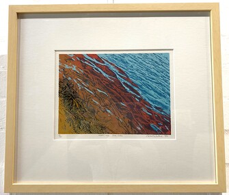
Artwork, other - Screen print, Carmel Wallace, Water's edge, Swan Lake, 1990
... Screen print of the waters edge, Swan Lake Discovery Bay..... Swan Lake Carmel Wallace Coastal Screen print Bottom edge below ...Carmel Wallace works out of a studio in Portland Victoria and is an award-winning artist and a finalist in major Australian prizes..Screen print of the waters edge, Swan Lake Discovery Bay Coastal Park. Hues of blues, red's, maroon, browns, tan and black for the edges grass matter. Bottom edge below the print in grey lead: 8/20 Water's Edge, Swan Lake Carmel Wallace '90swan lake, carmel wallace, coastal, screen print -
 Lakes Entrance Historical Society
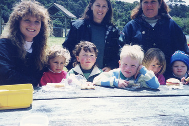
Photograph - Day Care, Lakes Post Newspaper, 1997
... , at picnic table Apex Park Lakes Entrance Victoria... McCubbin and Shaun Mitchelson, at picnic table Apex Park Lakes ...Colour photograph of Kilmany Family Day Care volunteers, Anna Cropper, Lyn White, and Gaye Eaton, with Bethany Loukes, Matthew Wright, Kabel Shiels, Kate McCubbin and Shaun Mitchelson, at picnic table Apex Park Lakes Entrance Victoriapeople, childrens services -
 Lakes Entrance Historical Society
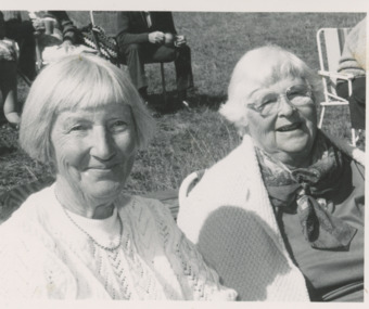
Photograph - Seniors Club, Lakes Post Newspaper, 1992
... visit to Wyanga Park Winery. Lakes Entrance Victoria... Senior Citizens Club during visit to Wyanga Park Winery. Lakes ...Black and white photograph Clarice Brooks and Stella Prawdzic, members of Swan Reach Metung Senior Citizens Club during visit to Wyanga Park Winery. Lakes Entrance Victoriasenior citizens, activities -
 Flagstaff Hill Maritime Museum and Village
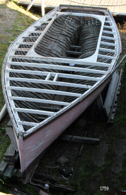
Vehicle - Vessel, Couta boat, Viator, 1890-1920
... photograph is of the Sturrock Coot, taken a Albert Park Lake in St... Park Lake"... photograph is of the Sturrock Coot, taken a Albert Park Lake in St ...The historic Victorian ‘couta boat “Viator” was built by renowned boat builder J.R. Jones of Williamstown in Melbourne, between 1890 and 1920. He was one of the early builders of this design. The features of Viator - carvel planked, open cockpit, vertical stem and straight keel, single mast and a pivoting centreboard - are all characteristics of an early Bass Strait ‘couta boat. This has been confirmed by experienced Victorian ‘couta boat restorer Tim Phillips. Viator served as a ‘couta fishing boat in the Warrnambool area until the mid-1930s, then some say she served as a mail ferry across to Portland. Later it was used as a fishing and recreation boat for local families. For years Viator sat in a paddock in East Warrnambool until purchased in 1975 and donated to Flagstaff Hill. ‘COUTA BOATS - The ‘couta design for vessels is believed to have originated at Port Phillip, Victoria, for the purpose of the Barracouta (‘couta) fishing industry, being both fast and seaworthy. , The 'couta fish was an important food fish in Australian waters, supplying Melbourne with plenty of inexpensive fish. VIATORY’S OWNERS - Some of Viator’s history is known: - 1940, registered Port Fairy and owned by G.J. Richards. - 1941-1945, registered in Port Fairy and owned by Jens “Peter” Petersen. - 1950’s “Brusher” Richards of Warrnambool and Port Fairy used it for fishing. - Peter Watson and his son also went fishing in Viator. - Frank Ferrier, boat builder, was an owner (son of ‘La Bella’ hero, William Ferrier) - Arthur Rogers owned Viator too, then sold it to Terry Pridmore and Wayne Moorefield - The Viator was stored in a paddock, unused for years, in Fairmont Avenue, Warrnambool, where it was gradually deteriorating. - 1975 Viator was purchase at a very reasonable price from Pridmore, then donated to Flagstaff Hill Maritime Village. RESTORATION - Shipwright Erik Mikkelsen soon started restoration on the Viator after it arrived at Flagstaff Hill in 1975. In 2006 the Maritime Museums of Australia awarded a grant to Flagstaff Hill Maritime Village to assist with the restoration and renovation of the Viator. Its restoration continues today in the care of Flagstaff Hill’s boat builder. J R. JONES - boat builder The photograph of the EVA MYRL shows the builder J R Jones with his team of workers. The other photograph shows a vessel built by J R Jones' son, J B Jones of Footscray, and his team of boat boulders. The photograph of the EVA MYRL was taken by E. A. Dond---. The other photograph is of the Sturrock Coot, taken a Albert Park Lake in St Kilda.The Viator is the most significant boat in the Flagstaff Hill's fleet, being the last remaining local 'couta boat and one of few existing examples of this craft. Viator received Heritage status with the Australian Maritime Museums Council and is listed on the Australian Register of Historical Vessels in 2006 (ARHV Number: HV000561). Viator was built in Victoria in the early days by renowned boat builder J.R. Jones, and sailed by fishermen for many years, both local and on the coastal waters of Victoria, and was possibly used for the mail service. It is significant for being used for the fishing trade, for government service, perhaps as a mail boat, and for recreation by local families.Vessel, the ‘Viator’, an historic Victorian ‘couta boat, handmade by renowned boat builder This J.R. Jones 'couta boat, the Viator, was built in Williamstown, c.1890-1920. The single mast vessel has a Caravel hull built from New Zealand Kauri, blackwood, with a red gum keel and a jarrah stem and stern. It has a pivoting centreboard. Two photographs are included; one of the builder with his team, the other is of his son J B Jones, with his team. Marked "Viator" Photograph 1759.2: "E. A. Dond---" (indecipherable". Handwritten on back "Grandfather / J R Jones / Built" Photograph 1759.3; sign within photograph "J B JONES / BUILDER / FOOTSCRAY", stamped in the card, bottom right " ----- / MELBOURNE" and handwritten on the back "I think this is Mr Abel Sturrock Coot Albert Park Lake"flagstaff hill, warrnambool, shipwrecked coast, flagstaff hill maritime museum, maritime museum, shipwreck coast, flagstaff hill maritime village, great ocean road, arhv hv000561, arthur rogers, bass strait ‘couta boat, “brusher” richards of warrnambool and port fairy, clinker hull boat, ‘couta crafted boat c 1890-1905, ‘couta fishing boat, erik mikkelsen shipwright, g.j. richards of port fairy, jens “peter” petersen, john lindsay, old mail boat, pivoting centerboard boat, peter watson, single-masted ketch, terry prodmore and wayne moorefield, vessel viator, viator a historical vessel, victorian ‘couta boat, victorian barracoota boat, warrnambool ‘couta boat, western victoria fishing boat, western victoria mail boat, hv000561, australian register of historical vessels, erik mikkelsen, j b jones, j b jones boat builder, footscray, sturrock coot, sturrock, j r jones, j r jones boat builder, williamstown, eva myrl -
 University of Melbourne, Burnley Campus Archives
Album - 35mm Colour slides, Seed Collection, 1985
... of Indigenous Plants and Environmental Weeds at Studley Park, Taylors... indigenous plants weeds studley park taylors lake burnley 1985 ...Student assignment - James Gillespie 94169610. 55 slides of Indigenous Plants and Environmental Weeds at Studley Park, Taylors Lake and Burnley Jan-April 1985. Labelled in pencil. Also handwritten notes and lists.students assignments, james gillespie, indigenous plants, weeds, studley park, taylors lake, burnley, 1985 -
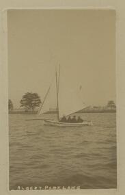 Bendigo Historical Society Inc.
Postcard - GLADYS DEAN COLLECTION: POSTCARD, 1906 - 1908
... Park Lake adhered to a backing card. Photograph has been placed... Park Lake adhered to a backing card. Photograph has been placed ...Photographic postcard with a sepia photograph of Albert Park Lake adhered to a backing card. Photograph has been placed slightly off centre and has a border varying from 1.5cm to 2.5cm. The photograph depicts a small yacht sailing on the lake with four men onboard with their backs to camera. In the background, the opposite shore can be seen with trees and a white railing fence. The words Albert Park Lake are printed across the bottom edge of the photograph. A laminated cover has been placed across the photo and backing card. On the reverse is writing and it is addressed to Mrs Dean Golden Square. A one penny stamp has been affixed to the top right hand corner and extended partly onto the front of the card.postcard -
 Stawell Historical Society Inc
Photograph, Victoria Park Stawell with the Wooden Rotunda (Now Cato Park)
... Post Cards. Victoria Park, Stawell, Victoria. Top right corner...). Shows young Willow Walk on right of lake . Renamed Cato Park ...Rose Series Postcard. Victoria Reserve later Cato Park at Head of the St George Mine Dam originally established with donations from Mr E Simmons and voluntary efforts. Shows rotundasB/W Photo The Rose Series P. 1643 Copyright of Stawell Post Cards. Victoria Park, Stawell, Victoria. Top right corner torn off. Shows a Wooden Rotunda with seating by Lake Victoria (now Cato Lake). Shows young Willow Walk on right of lake . Renamed Cato Park. Reverse: Real Photo POST CARD. The "Rose" Series DE Luxe Produced in Australia. Published by "The Rose Stereograph" Armadale Victoria. Rose emblem logo divides the post card.stawell -
Clunes Museum
Book, KATRINE ANDERSON KELLY 1994, SCRUB HILL CHURCH - A PASTORAL HISTORY, 1994
... SHOWS BLACK AND WHITE PHOTOS OF A SUNDAY SCHOOL ON PARK LAKE... SHOWS BLACK AND WHITE PHOTOS OF A SUNDAY SCHOOL ON PARK LAKE ...THE AIM OF THIS BOOK IS TO COMMEMORATE THE BUILDING OF THE PRESBYTERIAN CHURCH AT SCRUB HILL...A SOFT COVER BOOK, THE FRONT COVER IS A BLACK AND WHITE PASTORAL SCENE WITH AN INSET IMAGE IN BLACK AND WHITE OF A GROUP OF PEOPLE CONGREGATING AT THE FRONT OF THE CHURCH. THE BACK COVER SHOWS BLACK AND WHITE PHOTOS OF A SUNDAY SCHOOL ON PARK LAKE, CRESWICK, C 1925, BELOW ARE THE CHILDREN FROM A SUNDAY SCHOOL PLAY 1979THE AIM OF THIS BOOK IS TO COMMEMORATE THE BUILDING OF THE PRESBYTERIAN CHURCH AT SCRUB HILL...book, churches, presbyterian -
 Southern Sherbrooke Historical Society Inc.
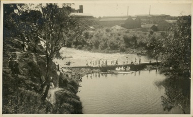
Photograph - People on the spillway of Belgrave Reservoir c.1940s
... Autocamp which is now called Belgrave Lake Park). The photo... is now called Belgrave Lake Park). The photo is taken from ...Black and white photo showing a group of people on the spillway of Belgrave Reservoir (at the time in the Belgrave Autocamp which is now called Belgrave Lake Park). The photo is taken from a person in a boat, the prow of which is visible at the bottom of the image. Three older boys are crouched to the left of the image. All are wearing shorts, shirts, and shoes with long socks, and two have pullovers. In the middle of the photo is a man with three children. The man is crouching. The children are in a huddle. To the right of the image are two adults standing on the spillway. The person on the right is male but the other's gender is uncertain. Between them and the children is what looks like a large portable radio. Behind the group is a heavily treed area which includes three or more white-trunked trees close to the spillway. In the distance is a white house with a verandah running across the front. This house belonged to Laura (surname unknown) before WW2. The house appears to be (now) 30 Judkins Ave.The photo has a white border and on the back is printed '1627'. It probably dates to the 1940s and is part of a collection of family photos donated by Pam Harris, Shire of Sherbrooke President, 1982-3 & 1987-1988. -
 Rutherglen Historical Society
Photograph - Image, 1962 (Approximate)
... Lake King in Rutherglen Park is a man made lake...-country Lake King in Rutherglen Park is a man made lake ...Lake King in Rutherglen Park is a man made lake and was the town's original reservoir for household water supplies. After the Water Tower was built, Lake King was used by the local children as a swimming pool. Since the Swimming Pool was built, Lake King has reverted to a beauty spot.Small black and white snapshot of Lake King and Pier and equipment used for Reservoir purposes - UnmountedOn back: "Lake King pre 1962 from Nokie Morrison"lake king, reservoir -
 The Beechworth Burke Museum
Photograph, Unknown
... Aerial view of Lake Sambell, Beechworth with town views...-country Aerial view of Lake Sambell, Beechworth with town views ...Aerial view of Lake Sambell, Beechworth with town views. Lake Sambell is a beautiful Victorian recreation lake and urban park with a unique history. It was created in the mid-1800s by the Rocky Mountain Mining company during the gold rush era and used as a mining site until the early 1900s, which brought Europeans into the area. It was turned into a reserve for residents in 1920 and is considered an icon of Beechworth as it represents the development of the community, human endeavour, and the spirit of the landscape.This photograph represents Lake Sambell with town views.Black and white reproduced rectangular photograph print on paper.Reverse: Stampbeechworth lake, lake sambell, aerial photo, construction, australian landscape, #beechworth, victoria -
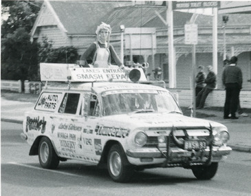 Lakes Entrance Historical Society
Photograph - Variety Club Bash, Lakes Post Newspaper, 1993
... of Carpenters Camp Park residence. Lakes Entrance Victoria... charities in front of Carpenters Camp Park residence. Lakes Entrance ...see page 16 Lakes Post Newspaper 23 June 1993Black and white photograph, motor vehicle EH station wagon, painted with names of sponsors, named the Spirit of Lakes Entrance, entry in Variety Club Bash for childrens charities in front of Carpenters Camp Park residence. Lakes Entrance Victoriacharities, clubs, vehicles -
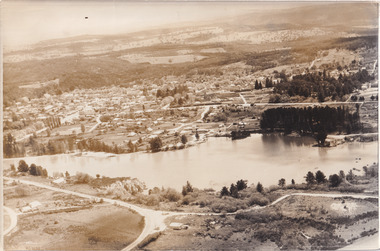 The Beechworth Burke Museum
Photograph, 1960
... recreation lake and urban park with a unique history. It was created... recreation lake and urban park with a unique history. It was created ...Taken in 1960, depicted is an aerial view of Lake Sambell and the surrounding township. Lake Sambell is a beautiful Victorian recreation lake and urban park with a unique history. It was created in the mid-1800s by the Rocky Mountain Mining company during the gold rush era and used as a mining site until the early 1900s, which brought Europeans into the area. It was turned into a reserve for residents in 1920 and is considered an icon of Beechworth as it represents the development of the community, human endeavour, and the spirit of the landscape.This photograph represents what Lake Sambell looked like in 1960.Black and white reproduced rectangular photograph print on paper.lake sambell, #beechworth, beechworth 1960s, lake, victoria, australian landscape, mining, rocky mountain mining company -
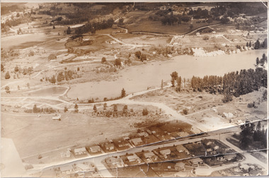 The Beechworth Burke Museum
Photograph, 1960
... Victorian recreation lake and urban park with a unique history... is a beautiful Victorian recreation lake and urban park with a unique ...Taken in 1960, depicted is the construction of Lake Sambell, looking west across the lake. Lake Sambell is a beautiful Victorian recreation lake and urban park with a unique history. It was created in the mid-1800s by the Rocky Mountain Mining company during the gold rush era and used as a mining site until the early 1900s, which brought Europeans into the area. It was turned into a reserve for residents in 1920 and is considered an icon of Beechworth as it represents the development of the community, human endeavour, and the spirit of the landscape.This photograph represents additional construction to Lake Sambell as a recreational reserve.Black and white reproduced rectangular photograph print on paper.beechworth lake, lake, lake sambell, construction, #beechworth, australian landscape, beechworth 1960s, victoria -
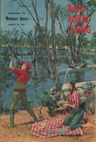 Bendigo Historical Society Inc.
Magazine - AILEEN AND JOHN ELLISON COLLECTION: BETTER RURAL LIVING
... is standing near a lake, a car is parked nearby and a female... with rifle taking aim, he is standing near a lake, a car is parked ...Better Rural Living from March 22, 1961 a supplement to weekly Times. On the cover: a man with rifle taking aim, he is standing near a lake, a car is parked nearby and a female is setting a picnic next to him. The magazine has 47 pages.books, magazines, weekly times -
 Rutherglen Historical Society
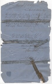
Document - Council permit, 1877 (Exact)
... Lake King in the park. Councillors signing were Geo. Audley... Lake King in the park. Councillors signing were Geo. Audley ...Letter granting permission to Mr Arthur Gribbin to shoot shag on the Water Supply Reserve. Mr Gribble was senior Constable of Police stationed at Rutherglen. Water supply came from Lake King in the park. Councillors signing were Geo. Audley / Andrew Hunter (M. Gunter?) William Meehan. [check names - Gribbin - Gribble]Document written in black ink on blue paper, stamped with seal of Rutherglen Municipality, granting permission to Mr Arthur Gribbin to shoot shag on the Water Supply Reserve"Borough of Rutherglen / Town Hall / Rutherglen / 1st October 1877" Signed by Councillors and Town Clerk Thos. Reevespermit, water supply reserve, lake king, shag, rutherglen borough -
 Lakes Entrance Historical Society
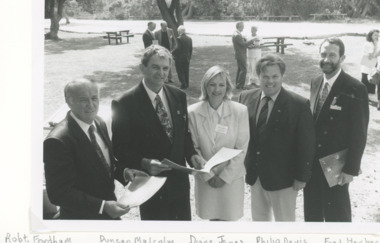
Photograph, Lakes Post Newspaper, Victorian Coastal strategy draft plan for Eastern Beach Lakes Entrance Victoria, 1/12/1996 12:00:00 AM
... strategy draft plan for Eastern Beach taken in Lions Park Lakes... for Eastern Beach taken in Lions Park Lakes Entrance Victoria ...Black and white photograph of Robert Fordham,Chairman Vic Coastal Council, Duncan Malcolm, Diane James Acting Chairman Vic Coastal Council, Philip Davis Gippsland Province MLC, Fred Herbert Gippsland Coastal Council taken during launch of Victorian Coastal strategy draft plan for Eastern Beach taken in Lions Park Lakes Entrance Victoriacoast, environment, volunteering -
 Kew Historical Society Inc
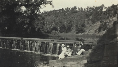
Photograph, Richardson Family at Dight's Falls, 1920
... Botanical Gardens and to Albert Park Lake. The area around Dight’s... Botanical Gardens and to Albert Park Lake. The area around Dight’s ...Dight’s Falls in Studley Park is an artificial weir built on a natural rock bar across the Yarra. The weir was built in the 1840s to provide water to the ‘Ceres’ flour-mill, one of the first in Victoria. The falls were later to become known as Dight’s Falls after the owners of the mill. Later, a pumping station was built on the Kew side of the river, which pumped water uphill to a reservoir in Walmer Street that provided water to the Melbourne Botanical Gardens and to Albert Park Lake. The area around Dight’s Falls was and is frequently used for recreational activities.This photograph forms part of the collection assembled by the historian Dorothy Rogers, that was donated to the Kew Historical Society by her son John Rogers in 2015. The manuscripts, photographs, maps, and documents were sourced by her from both family and local collections or produced as references for her print publications. Many were directly used by Rogers in writing ‘Lovely Old Homes of Kew’ (1961) and 'A History of Kew' (1973), or the numerous articles on local history that she produced for suburban newspapers. Most of the photographs in the collection include detailed annotations in her hand. The Rogers Collection provides a comprehensive insight into the working habits of a historian in the 1960s and 1970s. Together it forms the largest privately-donated collection within the archives of the Kew Historical Society.Black and white photograph of the Richardson family seated on the Kew side of Dight's Falls in 1920. One of the girls in the photograph was to become the Melbourne historian Dorothy (Richardson) Rogers.Annotation on reverse: "Mrs D. Rogers, 29 Park Crst Kew. Dights Falls 1920"dight's falls - kew (vic) - fairfield (vic), sport and recreation - kew (vic), dorothy rogers -
 Kew Historical Society Inc
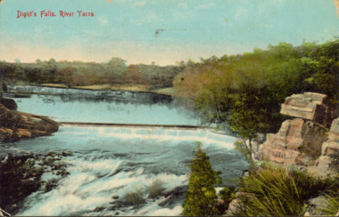
Postcard - Dight's Falls, River Yarra, c.1911
... Botanical Gardens and to Albert Park Lake. The area around Dight’s... Botanical Gardens and to Albert Park Lake. The area around Dight’s ...Dight’s Falls in Studley Park is an artificial weir built on a natural rock bar across the Yarra. The weir was built in the 1840s to provide water to the ‘Ceres’ flour-mill, one of the first in Victoria. The falls were later to become known as Dight’s Falls after the owners of the mill. Later, a pumping station was built on the Kew side of the river, which pumped water uphill to a reservoir in Walmer Street that provided water to the Melbourne Botanical Gardens and to Albert Park Lake. The area around Dight’s Falls was and is frequently used for recreational activities.Dated postcard allowing one to analyse the form of the Falls in 1911Colour postcard, of Dight's Falls on the River Yarra between Kew and Fairfield. The photograph is taken looking upstream towards the Falls from the Kew side, from the embankment in the vicinity of the Pumping Station. Obverse: "Dight's falls, Kew" Reverse: "Printed in Great Britain Writing in ink on Reverse: "31/3/1911 / To dear Nell with best wishes for a happy birthday from your old friend Eve / [Addressed to] "Mrs N Dunn, Prahran" Franked Victorian 1d stamp on Reverse top rightdight's falls, dight's falls - kew (vic) - fairfield (vic) -
 Kew Historical Society Inc
Photograph - Crossing Dights' Falls on the Yarra by foot
... Botanical Gardens and to Albert Park Lake. The area around Dight’s... Botanical Gardens and to Albert Park Lake. The area around Dight’s ...Dight’s Falls in Studley Park is an artificial weir built on a natural rock bar across the Yarra. The weir was built in the 1840s to provide water to the ‘Ceres’ flour-mill, one of the first in Victoria. The falls were later to become known as Dight’s Falls after the owners of the mill. Later, a pumping station was built on the Kew side of the river, which pumped water uphill to a reservoir in Walmer Street that provided water to the Melbourne Botanical Gardens and to Albert Park Lake. The area around Dight’s Falls was and is frequently used for recreational activities.Rare original print photograph of people walking across Dight's Falls when the river flow was low. View west towards Abbotsford. Photograph taken from Kew side of river above the Falls.Reverse: "M Holmes"dight's falls, river yarra -- kew - abbotsford -
 Kew Historical Society Inc
Photograph - Dight's Falls, 1920s
... Botanical Gardens and to Albert Park Lake. The area around Dight’s... Botanical Gardens and to Albert Park Lake. The area around Dight’s ...Dight’s Falls in Studley Park is an artificial weir built on a natural rock bar across the Yarra. The weir was built in the 1840s to provide water to the ‘Ceres’ flour-mill, one of the first in Victoria. The falls were later to become known as Dight’s Falls after the owners of the mill. Later, a pumping station was built on the Kew side of the river, which pumped water uphill to a reservoir in Walmer Street that provided water to the Melbourne Botanical Gardens and to Albert Park Lake. The area around Dight’s Falls was and is frequently used for recreational activities.One of a series of photographs, probably taken by Henry Christian of the Yarra River in Kew. An item from an outstanding and diverse photographic collection, assembled by members of the Christian and Washfold families of Kew.River Yarra at Dight’s Falls, Kew/Fairfield photographed from Kew bank.dight's falls, river yarra, christian-washfold collection -
 Kew Historical Society Inc
Photograph - The Race at Dight's Falls, 1925
... Botanical Gardens and to Albert Park Lake. The area around Dight’s... Botanical Gardens and to Albert Park Lake. The area around Dight’s ...Dight’s Falls in Studley Park is an artificial weir built on a natural rock bar across the Yarra. The weir was built in the 1840s to provide water to the ‘Ceres’ flour-mill, one of the first in Victoria. The falls were later to become known as Dight’s Falls after the owners of the mill. Later, a pumping station was built on the Kew side of the river, which pumped water uphill to a reservoir in Walmer Street that provided water to the Melbourne Botanical Gardens and to Albert Park Lake. The area around Dight’s Falls was and is frequently used for recreational activities.Original, black and white positive of water flowing over the 'Race' at Dight's Falls in MelbourneInscribed verso: "The Race at Dight's Falls / River Yarra Melbourne / 1.3.25" "Kodak Print"dight's falls, river yarra, yarra -- kew (vic.) -
 Greensborough Historical Society
Article - Article, Journal, Melbourne Harbor Trust, "The Word is Progress": by Robin Hay, 1960_03
... called Blue Lake in Yellow Gum Park, Plenty...., was on the site now called Blue Lake in Yellow Gum Park, Plenty. reids ...The opening of Reid's Lightweight Aggregate Pty Ltd ( a subsidiary of Reid's Quarries Ltd) in Greensborough, circa 1960. Explains the method of manufacture and uses of shalite in building industry. Reid's later became Albion Reid before being taken over by Boral. The shalite quarry, now closed, was on the site now called Blue Lake in Yellow Gum Park, Plenty.7 photocopied pages, text and colour and black nd white illustrations.reids quarries, shalite, aggregate, yellow gum park, plenty -
 Whitehorse Historical Society Inc.
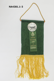
Badge - Badge on Banner, c.1985
... Green felt pennant with a badge of 'Friends of the Lake... pinned under the lake badge, Supporting Nunawading Parks ...See Ref NA4362Green felt pennant with a badge of 'Friends of the Lake' attached. The pennant also has a ribbon pinned under the lake badge, Supporting Nunawading Parks and Recreation Department. The writing and insignia on the ribbon is gold on green ribbon. The pennant has gold cord to hang and gold fringe stitched to the base.civic mementoes, souvenirs, trophies & awards, education -
 Lakes Entrance Historical Society
Postcard - Broome's Federal Hotel, 1920c
... of scene one motor car parked at lake edge, bluestone seawall... of scene one motor car parked at lake edge, bluestone seawall ...Also two other smaller postcards Also a larger copyBlack and White copy postcard of Broomes Federal Hotel showing a rambling weather board building. Launch with tourists aboard, on Lake two smaller craft moored at jetty, on left of scene one motor car parked at lake edge, bluestone seawall completed to west of jetty. Lakes Entrance VictoriaLakes Entrance Gippsland lakesguesthouses, boats and boating, waterfront, tourism -
 The Beechworth Burke Museum
Photograph, 1920
... is a beautiful Victorian recreation lake and urban park with a unique... is a beautiful Victorian recreation lake and urban park with a unique ...Taken in 1920, depicted are four people in a rowing boat on Lake Sambell, Beechworth. From left to right, it is believed that the names of the people are Eric Beard, Mrs Doris Beard, and S/L to Bert Beard. The last two figures are unknown. Lake Sambell is a beautiful Victorian recreation lake and urban park with a unique history. It was created in the mid-1800s by the Rocky Mountain Mining company during the gold rush era and used as a mining site until the early 1900s, which brought Europeans into the area. It was turned into a reserve for residents in 1920 and is considered an icon of Beechworth as it represents the development of the community, human endeavour, and the spirit of the landscape.This photograph represents the community's social use of the lake in 1920.Black and white rectangular photograph print on paper.Reverse: LAKE SAMBELL/ c 1920/ from LTOR/ 1 ERIC? - BERT'S SON/ 2 MRS DORIS BEARD/ 3 S/L TO BERT BEARD/ 4 #beechworth, lake sambell, lake sambell boating, beechworth lake, social, 1920, victoria -
 Ringwood and District Historical Society
Newspaper, Scrapbook Clipping, Library Collection, Ringwood, Victoria, `
... will increase at various Council leisure facilities. Ringwood Lake... at various Council leisure facilities. Ringwood Lake and Croydon Park ...``Newspaper clipping from "The Mail" 11-2-97, P14 COUNCIL BRIEFS Candidates for the Maroondah Council elections must lodge their nominations with the returning officer before 4pm, February 12. Fees will increase at various Council leisure facilities. Ringwood Lake and Croydon Park have been declared alcohol-free zones for the duration of the Festival of the Foothills on February 15-16. Various other council issues of minor sectional interest are included in this article.` -
 Ringwood and District Historical Society
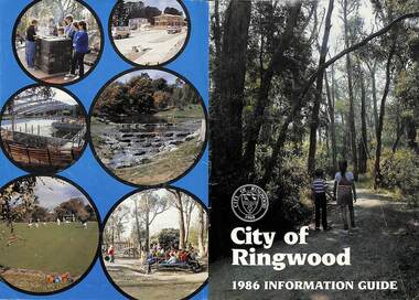
Booklet, City of Ringwood 1986 Information Guide, 1986
... at Jubilee Park, Playground at Ringwood Lake.... Park; Back L-R - Barbecue at Ringwood Lake, Housing ...Community information booklet issued by City of Ringwood for 1986 - covering the facilities and activities of the Ringwood Council and other local organisations and associations. Cover photographs: Front - Wombalano Park; Back L-R - Barbecue at Ringwood Lake, Housing construction at Ringwood, Enclosing swimming centre, Water cascade at rear of Ringwood Lake, Croquet at Jubilee Park, Playground at Ringwood Lake.CONTENTS: (page no.) After School Care Programme 30 & 31 Amalgamations 16 Aquatic Centre 14 & 15 Building Information 22 By-Law and Traffic Regulations 23 Chief Executive Message I0 Churches 38 Civic Centre 4 Committees of Council 5 Community Plan 12 & 13 Construction Work 34 Council Meeting Dates 4 Council Representatives 8 Councillors 6 & 7 Disabled Persons Facilities 41 Eastern Corridor Road Action Plan 17 Emergency Telephone Nos. 63 European Wasps 27 Family Day Care 30 Finances 18 Golf Course 22 Health 20 Historical Research Group 44 Home Help 33 Hospitals 45 Immunisations 2 i Incinerators 34 Infant Welfare Centres 45 Knaith Road Child Care Centre 30&31 Library 24 Local Area Traffic Management 17 Management Executive 11 Mayoral Message – Cr. W.R. (Bill) Wilkins, J.P. 3 Meals on Wheels 32 Members of Parliament 9 North Ringwood Senior Citizens 29 Parks for People 28 Playgroups 49 Pre-Schools 50 Rates 19 Rubbish — See Waste Ringwood District Centre 16 Schools 52 Swimming Pool — See Aquatic Centre 14 & 15 Waste 26rinx -
Southern Sherbrooke Historical Society Inc.
Council Ephemera - Shire of Sherbrooke, 1990s
... , Discover Emerald Lake Park -sheet of 28 round stickers featuring..., Discover Emerald Lake Park -sheet of 28 round stickers featuring ...Folder containing various pamphlets, etc. issued by Shire of Sherbrooke. Contents: -card 14x8cm, With the compliments of the Shire of Sherbrooke -card 14x8cm, You were absent when I called -bifold card 15.5x10cm, with print of painting on front, "Celebrating the Dandenongs" Neil Douglas 1990, artwork, and Shire logo on back, in plain envelope -trifold pamphlet, Monbulk Aquatic Centre Redevelopment Information -trifold pamphlet, An introduction to environmental & noxious weeds in Sherbrooke -trifold pamphlet, A responsible approach to dog ownership in Sherbrooke, stamped Rod Bezanovic, Ranger, Conservation and recreation -trifold pamphlet, A guide to Sherbrooke's animal welfare local law -trifold pamphlet, Community services in Sherbrooke -trifold pamphlet, Local law, Balancing the needs of native and domestic animals in Sherbrooke -trifold pamphlet, Litter -trifold pamphlet, Local law No 6 open air burning and incinerator use -trifold pamphlet, Garden plants are going bush...and becoming environmental weeds!/--trifold pamphlet, Local law No 6 open air burning and incinerator use -trifold pamphlet, Minimising waste -trifold pamphlet, Local law No 6 open air burning and incinerator use -trifold pamphlet, Our services at a glance -trifold pamphlet, Local law No 6 open air burning and incinerator use -trifold pamphlet, Putting up signs on roadsides, parks or reserves in Sherbrooke -trifold pamphlet, Local law No 6 open air burning and incinerator use -trifold pamphlet, Customer Feedback -bifold pamphlet, Discover Emerald Lake Park -sheet of 28 round stickers featuring Shire logo and "Shire of Sherbrooke Glenfern Road, Upwey" -A4 sheet, blue, Emerald Lake waterslide, with two complimentary ride tickets stapled to it -A4 sheet, red, listing Fire Hazard clearance contractors 1994/5shire of sherbrooke, resident information, bylaws -
 Melbourne Legacy
Document, Australia's Legacy is Worth Defending, 2006
... , ALbert Park Lake Defence Attack, a golf classic event... a National Junior Public Speaking Award, Badge appeal, ALbert Park ...A document summarising the work of Legacy in 2006. It mentions how it was begun by a group of WW1 veterans. At the time there were 126,000 widows and 1,900 children and adults with a disability being helped by Legacy around Australia. There were approximately 6,700 Legatees in 49 Legacy Clubs. In Victoria there were 1,700 Legatees providing support to about 24,000 widows and 300 disabled dependents. There were 13 clubs in Victoria as well as 12 Groups, plus Branches. Some of the activities Legacy was involved with include a National Junior Public Speaking Award, Badge appeal, ALbert Park Lake Defence Attack, a golf classic event and the Torch society Document was from a folder of documents donated to the archive by Legatee Bill Rogers that related to his time as President (March 2006 - March 2008).A summary of the work of Legacy in 2006.Print out x 2 pages about Legacy, its history and challenges.legatees, statistics