Showing 1512 items matching "land use"
-
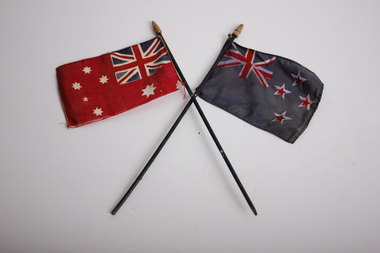 Dandenong/Cranbourne RSL Sub Branch
Flag - The Australian Red Ensign Flag and New Zealand Flag, unknown
... . It is for use only at sea and officially never on land, but can be used.... It is for use only at sea and officially never on land, but can be used ...Likely from WWIPair of miniature flags on small black flag poles with wooden caps. The Australian Red Ensign, or the Australian Civil Ensign, is simply a red version of the Australian National flag. It is for use only at sea and officially never on land, but can be used by private citizens. At sea, it is the only flag allowable for merchant ships registered in Australia under the Navigation and Shipping Act 1912 and The Shipping Registration Act 1981. Pleasure craft, however, may fly either the Red Ensign or the National Flag. The history of the Red Ensign is intertwined with the history of the Australian National flag. From 1901 to 1954 the Red Ensign was used as the National Flag by State and Local Governments, private organisations and individuals. The Blue Ensign was for Government use only, reflecting British practice with its ensigns. The design of the Australian Red Ensign was always kept in step with the Blue Ensign (i.e. with respect to the number of points on the stars, etc.) but there was often public confusion about which was the `correct′ flag to fly. Many thought the choice was merely one of fashion or preference. In 1941, Australia′s Prime Minister Robert Menzies stated that there should be no restrictions on private citizens using the Blue Ensign on land and, in 1947, Prime Minister Ben Chifley reaffirmed this position but it wasn’t until the passage of the Flags Act 1953 that the restriction on civilians flying the Blue Ensign was lifted after which, use of the Red Ensign on land became a rarity. Since 2008, 3 September has been officially commemorated as both Australian National Flag/Merchant Navy Day which allows the Australian Red Ensign to be flown on land for the occasion as a matter of protocol. The blue flag is the New Zealand National Flag.flag, ensign, anzac, new zealand, navy, naval -
 National Wool Museum
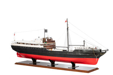
Model Ship, David Lumsden, SS Edina, 2018-2019
... up and her remains used as land-fill.... up and her remains used as land-fill. geelong transport ship ...The Edina was one of the longest serving steam vessels anywhere in the world. Built on the Clyde by Barclay, Curle & Co. she was an iron hull single screw steamer of 322 tons with three masts. In 1855 Edina was requisitioned by the Admiralty from her owners the Leith, Hull & Hamburg Steam Packet Co. to carry stores and horses to the Black Sea during the Crimean War. After return to her owners Edina traded around the UK and Mediterranean before being purchased and used as a blockade runner during the American Civil War carrying cotton from the Confederate states in 1861. Edina arrived in Melbourne under sail in March 1863 and was purchased by Stephen Henty for use from ports in western Victoria and later carried gold prospectors across the Tasman to New Zealand. After a refit in 1870 she was used in the coastal trade along the Queensland coast for Howard Smith until returning to Victoria and the Melbourne-Geelong trade as a cargo-passenger vessel. The Edina had two narrow escapes from destruction in 1898 and 1899 when she collided with other steamers, both being sunk. A further refit in 1917 altered her appearance with a new mast, funnel, bridge and promenade deck. By 1924 Edina had made over 12,000 Melbourne-Geelong passages and carried over one million people on the service. A further collision in July 1931 which sank the tug Hovell forced Edina onto a mudbank on Port Phillip Bay. She was taken out of service in 1938 but was later renamed Dinah and used as a lighter until 1958 when she was broken up and her remains used as land-fill.Model of a Coastal Trader & Passenger Ship with hull painted red and black. Red flag and black flag with S attached to flag pole. On forward of ship - Edinageelong, transport, ship model, water transport -
 Eltham District Historical Society Inc
Photograph - Digital Photograph, Marguerite Marshall, Eltham Lower Park, 20 April 2008
... the Parish of Nillumbik, later named Eltham. Soon the land was used... the Parish of Nillumbik, later named Eltham. Soon the land was used ...Originally a race course, the park has brought the community together with a variety of activities. Published: Nillumbik Now and Then / Marguerite Marshall 2008; photographs Alan King with Marguerite Marshall.; p45 Once used for horse racing, which attracted visitors from Melbourne, the Eltham Lower Park has brought the community together with a wide range of activities. Horse riding is now enjoyed as a recreation in the park as are other sports. The park also includes the Diamond Valley Railway miniature trains and a sanctuary for the rare and vulnerable Eltham Copper Butterfly. Eltham Lower Park, with other parks, forms an almost continuous green band from Eltham’s centre, along the Diamond Creek to the Yarra River.1 Before European settlement the Wurundjeri people met on this land, particularly at the junction of the Diamond Creek with the Yarra River, which they called Birr-arung. This is commemorated by the sculpture, Not just a Pretty Place by Aleks Danko, winner of the 2000 Nillumbik Art in Public Places Award. The first European to settle here was probably Henry Foley, who in 1841 used it as part of his pastoral run. Foley sold his leasehold to Joseph Wilson in 1845, who soon after sold it to Frederick Falkiner. During the 1840s the future park was part of a government square mile (2.6 sqkm) reserve, north of the Yarra, within the Parish of Nillumbik, later named Eltham. Soon the land was used for horse racing after nearby residents cleared ten acres (4ha) in the early 1850s. A three-quarter of a mile (1.2km) race secured the winner the £10 Publican’s Prize. In response to popular demand, the newly formed Eltham District Road Board petitioned the Surveyor General of the Colony of Victoria, in 1856, for 36 acres (14.6ha) of crown land for a racecourse and recreation. By 1858 the Eltham races had become an institution. ‘Many skirmishes occurred and the way home was paved with temptation, with sly-grog for sale.3 In the early 1870s, two jockeys were sons of the police officer in charge of the Eltham Police Station, Miles S Lyons. Another ten acres (4ha) was added to the area in 1866 and 12 acres (4.8ha) – Hohnes Hill – in 1870. In 1866, two acres (0.8ha) on the creek banks became an animal pound with William Walsh the pound keeper in 1870, but this was later incorporated into the park. By 1877 the area was called a public park but horse racing and training continued into the 1920s. In the mid-1900s trotters were trained on a circuit road. In 1953 the Eltham Pony Club was established and used a cross-country course on Hohnes Hill. From the mid 1950s the club held the Eltham Easter Fair at the park, later to include a procession along Main Road from the town centre to the park. The park also attracted picnic parties and campers from the inner suburbs as did Wingrove Park, and businesses catering for visitors, sprang up on the opposite side of Main Road. Bus-loads of school children visited the park for Gould League bird days in the 1960s. In 1979 the Eltham Shire Council bought Lenister Farm, linking the park with the Yarra River. The Lenister Farm wetland includes a bird hide, viewing platform and interpretive signs.5 Pioneer Henry Stooke, later Road Board chairman, bought the 11 acres (4.5ha) - later to become Lenister Farm - from the Crown in 1862. Stooke never lived on this site and the two houses at Lenister Farm were built in the 20th century. Since its formation in 1871, the Council has controlled this crown land, which it named Eltham Park. But in the 1920s Eltham Council bought land near the town centre for a park, which it named Eltham Central Park. To avoid confusion the Council renamed Eltham Park, Eltham Lower Park. Since 2004 the Yarra footbridge has linked the park with the Yarra Valley Metropolitan Park and the Main Yarra Trail.This collection of almost 130 photos about places and people within the Shire of Nillumbik, an urban and rural municipality in Melbourne's north, contributes to an understanding of the history of the Shire. Published in 2008 immediately prior to the Black Saturday bushfires of February 7, 2009, it documents sites that were impacted, and in some cases destroyed by the fires. It includes photographs taken especially for the publication, creating a unique time capsule representing the Shire in the early 21st century. It remains the most recent comprehenesive publication devoted to the Shire's history connecting local residents to the past. nillumbik now and then (marshall-king) collection, eltham lower park, eltham park -
 Ringwood and District Historical Society
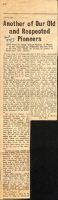
Newspaper, The Mail, Obituary - Joseph Richard Sanders - Old and Respected Pioneer Ringwood 1959 from the Ringwood Mail, 1959
... used to heighten up the railway bridge over Wantirna Rd... used to heighten up the railway bridge over Wantirna Rd ...The article was contributed by J.K.McCaskill, JP. a mayor of Ringwood in the years between 1924-1951.The Sanders family came from England and are mentioned in the book "Ringwood a Place of Many Eagles" by Hugh AndersonObituary from The Ringwood Mail of Joseph Richard Sanders of 18, Wantirna Road, Ringwood, aged 87 years. He came from a family who were early pioneers of Ringwood. he was born in Collingwood but schooled in Ringwood, married and brought up his family in Ringwood. He lived at 18, Wantirna Road .The article was contributed by J.K.McCaskill, JP. a mayor of Ringwood in the years between 1924-1951.Transcript: "The death occurred of Joseph Richard Sanders, 18 Wantirna Rd, Ringwood, on Wednesday, 21st October 1959, in his 87th year, marks the passing of another of Ringwood’s early pioneers. He was born in Collingwood in August 1873 and came to Ringwood with his parents when 15 months old. They made their home on land on what is now known as Jubilee Park (Fuller particulars of this Park will appear in ‘The Mail’ at a later date, also reference will be made to Wantirna Rd, in the early days it was known as West Prussia Rd). Joe went to the school held in the old homestead and orchard of Mr. Mills, just through the Heatherdale Road railway gates. He remembered many of the scholars, some of the boys and girls had to walk three and four miles to school through rough scrub paddocks in all kinds of weather. During the lunch hour a few of the boys generally went to the creek to fish for eels and would be late in getting back to school, greatly to the annoyance of the teacher. One day the fishing was good, and the boys rather reluctantly returned to the school late as usual. The teacher was furious and made them stand in front of the class but before inflicting punishment she called out to one of the boys to throw out that dirty bag he was holding. The lad gave the bag a shake and out wriggled a snake. There was immediately a general stampede from the classroom, led by the teacher. The school was closed for the rest of the afternoon. Another incident related to a few tramps who after the scholars had all gone home, generally camped for the night in an old back room in the homestead. One of the boys put a little gunpowder in this old fireplace and when the tramps lit the fire to boil their billies the old chimney and part of the old wall just collapsed. Joe, after leaving school, worked around the district for some time and later left Ringwood to live in other suburbs. He at one time was employed at the Aust Glass Works, and later as a carpenter worked on building the dome of the Railway Station at Flinders St. He married a Miss E. M. Wood in 1901 at Richmond and a few years afterwards returned to Ringwood and resided at No. 18 Wantirna Rd., where he reared a family' of three girls (Alice, Ethel, Joyce) and two boys (Robert and Joe). Joe recalled many interesting events of earlier years, such as the duplication of the railway line, and the cutting back of the embankment at the Goods Shed, the earth being used to heighten up the railway bridge over Wantirna Rd. The brickworks at Ringwood East and reference to early land surveys, the using of the heavy chain links before the use of the theodolite became general, and the many neighbours and friends whom he knew. He was interested in local public affairs and was fond of fishing. He proved himself a good citizen and was highly respected and esteemed throughout the district, and so another old pioneer passes on." (Contributed by J. K. McCaskill, J.P.) RM 19 Nov 1959 -
 Ringwood and District Historical Society
Memorabilia - Envelope, Packet: Ringwood Methodist Church - Anniversary Pamphlets, Cuttings, Pictures, Hand written notes
... the Methodist Church Trust for 30 years to use land in Ringwood... for 30 years to use land in Ringwood 13. Carols by Candlelight ...Churches - Ringwood Methodist Church3785.1 A hand written notes of the early history of the church. Several to the Town Clerk from the Ringwood Church trust and thr Public health department. 2. Minutes of meeting of the Ringwood Parsonage Trust 1909 and 1910 3. The Record of the Box Hill and Ringwood Methodist Circuits. Hand writen list of members of Ringwood Circuit. 4. Flyer for Back to Ringwood Methodist Church Jubilee, March 9th to 17th. 1929. Letter to Richard Carter from Aub (sic) who was eight years old at the time and can remember the Jubilee 4 Booklets about the Church Also a name tag for Miss V. Watson Assist. Secretary. Several cuttings, one full page spread from the newspaper about the Jubilee. 5. Ringwood Methodist Sunday School Tea and Meeting. Cutting from the Ringwood & Croydon Mail. The Wigley family were greatly represented. 6. Diamond Jubilee 17-28th. March ,1939 Program of Events 7. Six pages of hand written letters from the Methodist Circuit, letter to the Ringwood Councillors inviting them to the Centennary Celebrations of the Church,letter to the Town Clerk from Methodist Sunday School Surrey Hills regarding a picnic in Ringwood. 8. Ringwood United Churchmen's Association syllabus 1937 9. Pamphlet about Sunday Sport and the Christian Duty to Vote. 10.Ringwood Methodist Church news July 1963 11. Two Ringwood Methodist Church pamphlets for the 75th. Anniversary March 17th.-28th. 1954. 12.Copy of lease from the Methodist Church Trust for 30 years to use land in Ringwood 13. Carols by Candlelight (no year) and the Ringwood Methodist Church News March 1958, With memories of Christmas. 14.Pamphlet of the Laying of the Foundation Stone Saturday 18th. May 1963 and two pamphlets of the Opening and Dedication of the Ringwood Methodist church 9th. november 1963. 15.'The Messenger' Journal of the Ringwood Methodist Church December 1963. 16'. Forward in Faith' Review Stewardship Canvass August 1961. 11 pages outlining the plans for the proposed new Church. 17. Foolscap sheet typed with the Evening Service Sunday 6th. December 1970 with the Combined Circuit Choirs .Excerpts from 'The Messiah' 18. 'Recollections of Ringwood Methodism' issued at the celebration of the 98th. Anniversary of the Church 29th. may 1977. Compiled by Alf. Clark 19.Syllabus for the Uniting Church Fellowship Ringwood 1984 20.' Methodist Pioneers in the Croydon Area'. Work in Progress by Rev. Barry Brown 21.two page history of the ' Pipe Organ in the Ringwood Uniting Church' which was built by the Melbourne firm of Geo. Fincham & Sons. Plus a pge with' A Few Facts about the Organ' 22. Two Church Christmas cards (no year). one in envelope -
 Eltham District Historical Society Inc
Photograph - Digital Photograph, Alan King, Shillinglaw Cottage, 6 January 2008
... . The northern part of the remaining land was then used for some.... The northern part of the remaining land was then used for some ...Covered under National Estate, National Trust of Australia (Victoria) Local Significance and Heritage Overlay, Nillumbik Planning Scheme. Published: Nillumbik Now and Then / Marguerite Marshall 2008; photographs Alan King with Marguerite Marshall.; p95 Thanks to an Australia first effort by local residents, the historic Shillinglaw Cottage still survives. The cottage at Panther Place, Eltham, once stood about 100 metres away on Main Road. But in 1963 it faced demolition to make room for the Eltham Shire Offices (since demolished). However residents rallied to save Shillinglaw Cottage and became the first in Australia to remove and reconstruct an early settler’s brick building. A fundraiser was the residents’ compilation of loved recipes into the cookery book, Flavour of Eltham. The cottage, built in the late 1870s by noted pioneer builder George Stebbing, is one of Eltham’s earliest buildings and associated with significant early settlers. It is on the National Estate and National Trust Registers. The cottage was constructed with handmade bricks in the Flemish Bond style, typical of cottages and farmhouses in Flanders, Europe. It features burnt ‘header’ bricks over the façade, which gives a chequered effect. The roof is made of slate, while the windows are 12-paned sash with relieving arches. It is not clear who were the first owners of the cottage. The National Trust claims that Stebbing built it for farmer Thomas Cochrane.1 Others say Cochrane first owned the land but Stebbing was Shillinglaw’s first owner and remained so until 1887. The Shillinglaw family then bought it and lived there for around 80 years until 1963 when they sold it to the Eltham Council.2 Farmer Thomas Cochrane bought the Shillinglaw Cottage site from land developer Josiah Holloway. The site was the largest in what Holloway called Little Eltham, of some 30 acres (12 ha), extending along the creek from Henry Street to Luck Street. In 1874 Cochrane sold the land to George Stebbing. Meanwhile in 1861, Stebbing was the owner and occupier of a house at Pitt Street, Eltham, which he had built. Evelyn Observer journalist James Rossiter rented the Pitt Street house, then in 1881 Phillip Shillinglaw occupied it. Stebbing constructed several buildings of note in the area, including the Uniting Church at John Street, the building beside it – a former bank – and St Margaret’s Church of England in Pitt Street. Stebbing was also an Eltham Shire Councillor from 1871 to 1873 and a trustee and treasurer of the Eltham Wesleyan Church.3 In the 1870s he is recorded as the owner of up to five houses. Earlier he had been described as a bricklayer and later became a farmer. In 1882 Stebbing returned to the Pitt Street house and Shillinglaw occupied the new house in Main Road, which he owned from 1887. Shillinglaw was a prolific poet and preached at the Eltham Primitive Methodist Church, where he also served as Sunday School superintendent and led the Young People’s Society Christian Endeavour. The Shillinglaws saw many changes in their property’s boundaries – the major one occurring at the turn of the century when land for the railway and Eltham station was acquired from their holding. The northern part of the remaining land was then used for some of the first commercial developments in what was to become the Eltham Shopping Centre. Later still, the land immediately north of the cottage was bought by the Eltham War Memorial Trust for the War Memorial Buildings and the fire station. The Trust’s land eventually passed to the council. The council bought the remaining two acres (0.8 ha) with the house, and with the exception of the commercial development between the fire station and the post office, all of the former Shillinglaw land is owned by the council or government instrumentalities.4 Since the late 20th century, the cottage has had varied uses, such as a handcrafts store and as a restaurant.This collection of almost 130 photos about places and people within the Shire of Nillumbik, an urban and rural municipality in Melbourne's north, contributes to an understanding of the history of the Shire. Published in 2008 immediately prior to the Black Saturday bushfires of February 7, 2009, it documents sites that were impacted, and in some cases destroyed by the fires. It includes photographs taken especially for the publication, creating a unique time capsule representing the Shire in the early 21st century. It remains the most recent comprehenesive publication devoted to the Shire's history connecting local residents to the past. nillumbik now and then (marshall-king) collection, shillinglaw cottage -
 Eltham District Historical Society Inc
Photograph - Digital Photograph, Alan King, Edendale Farm Homestead, 29 January 2008
... as Edendale. Cool did not farm the land, instead using... as Edendale. Cool did not farm the land, instead using ...Edendale Farm is Nillumbik Shire Council's environment centre situated in Gastons Road, Eltham between the railway and the Diamond Creek. The homestead on the property was built in 1896 and is of historical significance, being the subject of a Heritage Overlay under the Nillumbik Planning Scheme. The Edendale property was originally part of an extensive land purchase in 1852 from the Crown by pioneer Eltham farmer Henry Stooke. He initially purchased 51 acres and later expanded his holdings by purchasing another three adjacent Crown allotments extending northerly from Josiah Holloway's Little Eltham subdivision. Despite clearing the land, Stooke did not build on this property, choosing to live on his property "Rosehill" at Lower Plenty. In 1896 Thomas Cool, Club Manager of the Victoria Coffee Palace in Melbourne purchased 7 acres of the original Stooke land and built the house now known as Edendale. Cool did not farm the land, instead using it as a gentleman’s residence, retiring to Eltham at weekends. In 1918 he purchased an additional 7 acres but in 1919 he sold the property. Later owners included J.W. Cox, the Gaston family and D. Mummery. In the 1980s the Eltham Shire Council purchased the site for use as a Council depot, but this use did not proceed. Subsequently, it was used as the Council pound. The Edendale Farm Pet Education and Retention Centre was established in the summer of 1988/1989 and was set up to replace the existing dog kennels with a high standard pet retention centre. The design style of the building was established to compliment the features of the existing house. It was equipped with 10 retention pens, a veterinary room and a pet education area where school children and other interested parties learnt about pet care procedures. It was later developed into a community farm and was run by an advisory committee and in 2000 it became an Environment Centre. In early 2006 an advisory committee was established for the development of a master plan for future development at Edendale Farm. The committee included Russell Yeoman, a former long-time shire planner and founding member of the Eltham District Historical Society. At the time of filming the Master Plan and future for Edendale was about continuing to develop Edendale as a centre of environment learning and looking at expanding displays and school program, running a lot more of life-long learning and workshops around sustainable living. Covered under Heritage Overlay, Nillumbik Planning Scheme. Published: Nillumbik Now and Then / Marguerite Marshall 2008; photographs Alan King with Marguerite Marshall.; p101 A sharp turn from busy Wattletree Road by the railway line, brings a surprise. Only 1.4 km from Eltham’s centre, sheep feed, blissfully unaware of the hectic suburban activity so close by. At the entrance to the 5.6ha Edendale Farm is another surprise. A work of art that looks like huge tree trunks transformed into bowler and top-hatted men. The Fences Act 1968 by Tony Trembath with Mark Cain and John Doyle, 1996, is classified by the National Trust of Australia as having Regional Significance. The title refers to a government act on disputes between neighbors over the placement of fences and boundaries. This takes a ‘wry swipe’ at a community divided by trivial squabbles. It also celebrates making do with limited resources.1 Further along on the left, the office wall is decorated with a massive Eltham Copper Butterfly, designed by Robert Tickner and made by school children with used plastic bottles and other waste material. Nillumbik Council runs Edendale as an Environmental Education Centre, to help preserve and enhance the local environment. As early as 1988 the former Eltham Shire Council realised Edendale’s importance in meeting people’s needs, particularly of children, to enjoy farmland. The centre, with the Eltham North Reserve to the north - including remnant bushland and open parkland - makes up the major part of the public open space for this area. The council considers this area will become increasingly important to the local community for recreational use.2 Educational programs aim to encourage community involvement to ensure the long-term rehabilitation and protection of natural bushland areas. Edendale is used by people of all ages - from school children to adults - for environmental programs and workshops, as well as for recreation, to enjoy the domestic animals and to picnic. Edendale is also home to the Environmental Works staff who manage reserves and roadsides and support Nillumbik Friends environmental groups. The Friends propagate plants at the nursery, which grows indigenous plants and sells these to the public.3 The centre demonstrates the sustainable living the farm teaches, with features like solar hot water and drive lighting and for the fireplace, logs of recycled cardboard. Edendale has had a varied history as a dog pound and even as a retreat for Thomas Cool, Club Manager of the Victoria Coffee Palace in Melbourne. His single-storey weatherboard house built in 1896, which still stands, was grander than most homes in Eltham. Although such buildings were common in many other parts of Melbourne, Eltham’s poverty and remoteness did not encourage such construction. The Victorian rectangular-shaped house, with a corrugated iron roof and veranda, has elegant large rooms, leadlight windows, ceiling roses, two bay windows and ornately carved wooden fireplace surrounds. Cool bought seven acres (2.8ha) from pioneer Eltham farmer Henry Stooke’s 200 acre (81ha) farm, which he had bought from the Crown in 1852. In 1918 Cool bought an extra seven acres (2.8ha) but in 1919 sold the estate to farmer John Cox. In 1933 Cox sold Edendale to Mrs Elizabeth Gaston, after whom the road leading to the centre was named. The property was owned by several Gaston family members, who called it Edendale, then by a police constable, Douglas Mummery, until the Shire of Eltham bought it in 1970. Oddly Edendale was known as Mummery’s for almost 20 years, although Mummery owned it only for a short time.4 The shire used Edendale as a dog pound until amalgamation with other municipalities in 1996. The pound then moved to the Yan Yean Road, Plenty site, which had been used by the former Diamond Valley Shire Council. To the west and north the centre is bounded by Diamond Creek and on the east by the Melbourne-Hurstbridge railway line. Part of the Research creek forms the centre’s southern boundary.This collection of almost 130 photos about places and people within the Shire of Nillumbik, an urban and rural municipality in Melbourne's north, contributes to an understanding of the history of the Shire. Published in 2008 immediately prior to the Black Saturday bushfires of February 7, 2009, it documents sites that were impacted, and in some cases destroyed by the fires. It includes photographs taken especially for the publication, creating a unique time capsule representing the Shire in the early 21st century. It remains the most recent comprehenesive publication devoted to the Shire's history connecting local residents to the past. nillumbik now and then (marshall-king) collection, edendale farm -
 Eltham District Historical Society Inc
Photograph - Digital Photograph, Alan King, Wycliffe Centre, Graham Road, Kangaroo Ground, 2008
... delighted, as she had wanted her land to be used for ‘God’s service... delighted, as she had wanted her land to be used for ‘God’s service ...Wycliffe translates the Bible for people around the world. Published: Nillumbik Now and Then / Marguerite Marshall 2008; photographs Alan King with Marguerite Marshall.; p171 The peace and beauty of Australia’s Wycliffe Centre reflects what it aims to bring to thousands of people around the world. Kangaroos calmly feed, accompanied by bird song, near the mud-brick buildings set amongst Kangaroo Ground’s rolling hills. On 11 hectares off Graham Road, the centre aims to transform people’s lives by giving groups around the world, with no written language, help with literacy and Bible translation into their own tongue. Associate Director, Harley Beck, says reading the Bible (probably history’s most influential collection of books), in one’s own language, provides a strong moral basis, helping people withstand exploitation and escape poverty. One of Wycliffe’s field partners, SIL (formerly Summer Institute of Linguistics) Papua New Guinea, has won two UNESCO awards, and SIL branches in many other countries have won international and national awards. The translators are modern heroes. They undertake hardships, forsaking for years, sometimes decades, a salary and the soft western lifestyle, to face loneliness and primitive conditions that most of us would not even contemplate. No staff is paid a salary. An example is the first Australian Director and former International President, David Cummings, who for 50 years has depended on donations from supporters and churches. Students of all ages at the EQUIP Training School on the site come from all walks of life. They train in linguistics and learn how to communicate in a way that is sensitive to other cultures. Spiritual resilience is encouraged, enabling people to persist until the job in the field is done, which takes on average ten to 15 years. Courses range from a few weeks to a year. The Wycliffe concept was born in the 1920s when American missionary, Cameron Townsend, found a Spanish Bible was inadequate to evangelise the Cakchiquel people of Guatemala. When a Cakchiquel man challenged: ‘If your God is so great, why doesn’t he speak my language?’ Townsend decided to translate the Bible into all languages! He founded a linguistics training school in 1934, naming it after 14th century theologian John Wycliffe, the first to translate the Bible into English. The first Wycliffe Bible was completed in 1951 in the Mexican San Miguel Mixtec language. In May 2007 after 30 years of work, Wycliffe Australia, with other organisations, completed the first Bible for indigenous people in the Kriol* language, for about 30,000 people in northern Australia. Wycliffe Australia began in 1954 in the Keswick Bookshop basement, Collins Street, Melbourne. As the organisation grew, its quarters became so cramped that Director Cummings at times interviewed potential recruits in his car! The development of the Kangaroo Ground property is a story of faith and generosity. In 1967 Cummings proposed moving to a larger property despite having no funds. Within a month Wycliffe received a $20,000 donation and a gift of land towards a national centre. An earlier owner of the Kangaroo Ground property, Mrs Elsie Graham, would have been delighted, as she had wanted her land to be used for ‘God’s service’. Mud-brick architect and Christian, Alistair Knox, offered to design the centre at no charge. Despite a drought, straw was donated to make bricks. Many volunteers helped with the building, including church youth groups who made mud-bricks. Volunteers planted thousands of native plants, watered by recycled water from the site’s dam. Building began in 1968 and in 1983 the South Pacific SIL School (now EQUIP Training) followed. Wycliffe, the world’s largest linguistic organisation, and other organisations, have translated the Scriptures into more than 2000 languages. But another 2000 languages still lack any portion of the Bible. However translations are now completed more quickly, because of new computer programs and as education spreads, more speakers of the local language can assist. Despite the growth of secularisation, Beck says support for Wycliffe Australia, which has offices in all states and the ACT, is stronger than ever. * Kriol is a Pidgin language, which has become a speech community’s prime language.This collection of almost 130 photos about places and people within the Shire of Nillumbik, an urban and rural municipality in Melbourne's north, contributes to an understanding of the history of the Shire. Published in 2008 immediately prior to the Black Saturday bushfires of February 7, 2009, it documents sites that were impacted, and in some cases destroyed by the fires. It includes photographs taken especially for the publication, creating a unique time capsule representing the Shire in the early 21st century. It remains the most recent comprehenesive publication devoted to the Shire's history connecting local residents to the past. nillumbik now and then (marshall-king) collection, graham road, kangaroo ground, wycliffe centre -
 Eltham District Historical Society Inc
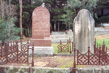
Photograph, Peter Pidgeon, Graves of William J and Mary Jane (nee Vance) Crozier and their sons Thomas Vance and John McClelland Crozier, Eltham Cemetery, Victoria, 5 April 2021
... Crozier used the land for cultivation and grazing. The track... Crozier used the land for cultivation and grazing. The track ...William Crozier was born 1823 in County Armagh, Ireland. Mary Jane Vance was born 1829 in Desecrete, County Tyrone, Ireland. They were married in 1848. On New Year's Eve, 1849, together with their baby daughter Sarah, William and Mary embarked from Plymouth aboard the Eliza Caroline, as assisted immigrants, for Port Phillip, arriving 31 March 1850 from where they journeyed out to Eltham on a bullock wagon. The Croziers were Episcopalians and soon after arriving in Eltham the Wesleyans of Little Eltham were holding services in the Crozier's home, among other locations. It was not until January 1856 that the Wesleyan church first acquired land in Henry Street for a chapel, which later became the home of the Eltham Hall. The Crozier home, known as ‘Belmont’ was weatherboard with a rammed earth floor. It was situated on twenty-four acres along the track at its rise, about half-a-mile east of Maria Street (Main Road) bounded by Mt Pleasant Road on the south and Pitt Street northwards. William Crozier used the land for cultivation and grazing. The track the Eltham Wesleyans took, by foot or horse, was along the Mt Pleasant Road, and like most roads of the time, a dusty trail in summer and a hoof and cart rutted quagmire in winter. William and Mary Crozier had seven children: Sarah, (1848 Ireland), John McClelland (1851 Eltham), Eliza (1855 Eltham), William (1857 Eltham), Jane(1859 Yarraville), Charlotte Amelia (1861 Yarraville), and Thomas Vance (1864 Eltham). The Crozier farm prospered and in 1870, William applied for, and was granted a leasehold on an additional sixty-three-acre selection, half-a-mile east of his twenty-four-acre Mt Pleasant Road property. Upon this property he built a two-roomed dwelling of slats and bark and a storeroom of log and bark, ten feet square. In 1880 he applied for a Crown grant of the property. Tragedy struck the family in 1882 when the youngest, Thomas Vance at age 17 accompanied by John Anderson, went into "Hall's Dam" to bathe, neither of them being able to swim. On wading out together, Crozier suddenly slipped into a part about 10ft. deep, and sank, after rising only once. Anderson pluckily tried to save him, nearly losing his own life in the attempt, saving himself when sinking for the last time by seizing hold of a projecting root. The body was not recovered until two hours after, when Mr. Thomas Bell, a farmer in the locality, who was attracted to the spot, on hearing of the occurrence, although unable to swim, plunged in with a rope around his waist, and succeeded with some difficulty in bringing it to the surface. Their eldest son, John also died prematurely at age 42 when he was killed by a falling tree branch whilst engaged in ring-barking trees at Eltham. A still cold wind was blowing and John, and others who were working with him, sheltered themselves at lunch time by sitting on the side of a large tree. When thus seated, the wind detached a limb of the tree which sheltered them, and though they heard the cracking, they had not time to get clear before the limb fell. It struck John on the head, and felled him to the ground, He appeared to be suffering severe pain, and two of his companions conveyed him to the Melbourne Hospital, where during the night he was operated upon for a fracture of the skull. Despite the operation being successful, John ultimately succumbed to his injuries the following afternoon. In good times William was known for his wealth of reminiscences of the early days of the district however his health failed him for several years until his death in March 1909. He was a man of very industrious habits, of a retiring disposition and much esteemed by those who knew him best. Mary died in January 1915 after a long illness. They are buried together along with their sons John and Thomas in the Eltham Cemetery. In Loving Remembrance William Beloved husband of Mary Jane Crozier Who departed this life March 31st 1909, aged 85 years Also Mary Jane Beloved wife of the above Who departed this life January 3rd 1915, aged 86 years Also John McCelland Son of the above Who departed this life May 20th 1894, aged 42 years also Sacred Memory of Thomas Vance Dearly beloved son of William J. Crozier Who departed this life at Eltham, February 3rd 1882 Aged 17 yearsBorn Digitaleltham cemetery, gravestones, john mccelland crozier, mary jane crozier (nee vance), thomas vance crozier, william j crozier -
 Eltham District Historical Society Inc
Negative - Photograph, Harry Gilham, Graves of William J and Mary Jane (nee Vance) Crozier and their sons Thomas Vance and John McClelland Crozier, Eltham Cemetery, Victoria, 1 Aug 2007
... Crozier used the land for cultivation and grazing. The track... Crozier used the land for cultivation and grazing. The track ...William Crozier was born 1823 in County Armagh, Ireland. Mary Jane Vance was born 1829 in Desecrete, County Tyrone, Ireland. They were married in 1848. On New Year's Eve, 1849, together with their baby daughter Sarah, William and Mary embarked from Plymouth aboard the Eliza Caroline, as assisted immigrants, for Port Phillip, arriving 31 March 1850 from where they journeyed out to Eltham on a bullock wagon. The Croziers were Episcopalians and soon after arriving in Eltham the Wesleyans of Little Eltham were holding services in the Crozier's home, among other locations. It was not until January 1856 that the Wesleyan church first acquired land in Henry Street for a chapel, which later became the home of the Eltham Hall. The Crozier home, known as ‘Belmont’ was weatherboard with a rammed earth floor. It was situated on twenty-four acres along the track at its rise, about half-a-mile east of Maria Street (Main Road) bounded by Mt Pleasant Road on the south and Pitt Street northwards. William Crozier used the land for cultivation and grazing. The track the Eltham Wesleyans took, by foot or horse, was along the Mt Pleasant Road, and like most roads of the time, a dusty trail in summer and a hoof and cart rutted quagmire in winter. William and Mary Crozier had seven children: Sarah, (1848 Ireland), John McClelland (1851 Eltham), Eliza (1855 Eltham), William (1857 Eltham), Jane(1859 Yarraville), Charlotte Amelia (1861 Yarraville), and Thomas Vance (1864 Eltham). The Crozier farm prospered and in 1870, William applied for, and was granted a leasehold on an additional sixty-three-acre selection, half-a-mile east of his twenty-four-acre Mt Pleasant Road property. Upon this property he built a two-roomed dwelling of slats and bark and a storeroom of log and bark, ten feet square. In 1880 he applied for a Crown grant of the property. Tragedy struck the family in 1882 when the youngest, Thomas Vance at age 17 accompanied by John Anderson, went into "Hall's Dam" to bathe, neither of them being able to swim. On wading out together, Crozier suddenly slipped into a part about 10ft. deep, and sank, after rising only once. Anderson pluckily tried to save him, nearly losing his own life in the attempt, saving himself when sinking for the last time by seizing hold of a projecting root. The body was not recovered until two hours after, when Mr. Thomas Bell, a farmer in the locality, who was attracted to the spot, on hearing of the occurrence, although unable to swim, plunged in with a rope around his waist, and succeeded with some difficulty in bringing it to the surface. Their eldest son, John also died prematurely at age 42 when he was killed by a falling tree branch whilst engaged in ring-barking trees at Eltham. A still cold wind was blowing and John, and others who were working with him, sheltered themselves at lunch time by sitting on the side of a large tree. When thus seated, the wind detached a limb of the tree which sheltered them, and though they heard the cracking, they had not time to get clear before the limb fell. It struck John on the head, and felled him to the ground, He appeared to be suffering severe pain, and two of his companions conveyed him to the Melbourne Hospital, where during the night he was operated upon for a fracture of the skull. Despite the operation being successful, John ultimately succumbed to his injuries the following afternoon. In good times William was known for his wealth of reminiscences of the early days of the district however his health failed him for several years until his death in March 1909. He was a man of very industrious habits, of a retiring disposition and much esteemed by those who knew him best. Mary died in January 1915 after a long illness. They are buried together along with their sons John and Thomas in the Eltham Cemetery. In Loving Remembrance William Beloved husband of Mary Jane Crozier Who departed this life March 31st 1909, aged 85 years Also Mary Jane Beloved wife of the above Who departed this life January 3rd 1915, aged 86 years Also John McCelland Son of the above Who departed this life May 20th 1894, aged 42 years also Sacred Memory of Thomas Vance Dearly beloved son of William J. Crozier Who departed this life at Eltham, February 3rd 1882 Aged 17 yearseltham cemetery, gravestones, memorials, film - kodak gold gc 400-9, john mccelland crozier, mary jane crozier (nee vance), scan - 35mm negative, thomas vance crozier, william crozier, william j crozier -
 The Beechworth Burke Museum
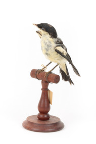
Animal specimen - White Winged Triller, 1860-1880
The White Winged Triller is a small member of the Campephagidae family. They can be found all over the Australian mainland, but there have also been sightings in Tasmania, Papua New Guinea and Indonesia. Their breeding season is from September to December, when they migrate to southern Australia for the warmer months. The males can be very noisy during this time, when they 'trill' all day, granting them their name. Throughout the winter they can be found in northern Australia. This species can be found in open areas with shrub and lots of ground cover, in woodlands, forests, scrub and waterways. The males and females are noticeably different, particularly when breeding. Breeding males are the most conspicuous, with black on their heads, bodies and wing coverts, with a white body, lower face and lower wings. Females are brown, with a light body, a faint brow and a dark line through their eyes. When not in the breeding season, males are similar to females, though they have a greyer rump. These birds have a netted pattern on their wings. When in flight they undulate, and when they land they often shuffle and re-fold their wings. This species predominantly forage for insects on the ground or tree foliage, but also 'hawks' insects from higher perches. They build nests on horizontal branches or forks, and can be found sometimes using empty nests of other birds. Many of these birds can be found nesting in the same tree as a colony, and both parents incubate and brood their two to three nestlings. This specimen is a male White Winger Triller, which is apparent from his black and white colouring. While missing some plumage, the distinction between black wings, tail, cap and wing covert are still clear against his white body and under-wings. This specimen is part of a collection of almost 200 animal specimens that were originally acquired as skins from various institutions across Australia, including the Australian Museum in Sydney and the National Museum of Victoria (known as Museums Victoria since 1983), as well as individuals such as amateur anthropologist Reynell Eveleigh Johns between 1860-1880. These skins were then mounted by members of the Burke Museum Committee and put-on display in the formal space of the Museum’s original exhibition hall where they continue to be on display. This display of taxidermy mounts initially served to instruct visitors to the Burke Museum of the natural world around them, today it serves as an insight into the collecting habits of the 19th century.This specimen is part of a significant and rare taxidermy mount collection in the Burke Museum. This collection is scientifically and culturally important for reminding us of how science continues to shape our understanding of the modern world. They demonstrate a capacity to hold evidence of how Australia’s fauna history existed in the past and are potentially important for future environmental research. This collection continues to be on display in the Museum and has become a key part to interpreting the collecting habits of the 19th century.This male White Winged Triller has a black cap on its head. It has black wings with black wing coverts, and a black tail. It has a white lower face and body, a white shoulder bar and white under-wings. This specimen stands upon a wooden post, attached to a wooden post and has an identification tag tied around its leg. Swing-tag: 22a / White shouldered Campephagidae/ See catalogue, page 11. /taxidermy mount, taxidermy, animalia, burke museum, beechworth, australian museum, skin, reynell eveleigh johns, bird, triller, white winged triller, campephagidae, australian birds -
 The Beechworth Burke Museum
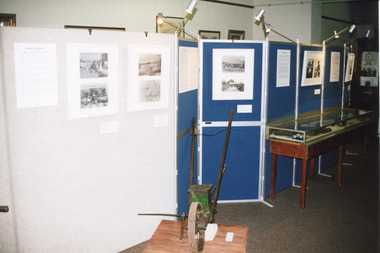
Photograph, Estimate 1999
This photograph was taken in 1999 at 'The Harvest' exhibition at the Burke Museum for members of Baking Industry Victoria. The grain mill, manufactured by B.M. Purshouse in Wolverhampton, England, was of special interest.This photograph is of primary social significance to the Beechworth community because it depicts a 19th-century grain mill, manufactured by B.M. Purshouse in Wolverhampton, England, which was probably used at flour mills in the Ovens District, such as that at Tarrawingee, which opened in 1866. The purchase of agricultural machinery such as the grain mill accompanied the expansion of agriculture, including grain growing, in the Ovens District following the gold mining prosperity of the 1850s. This photograph may be of interest to researchers who wish to observe an image of the Purshouse grain mill.Colour rectangular photograph printed on matte AGFA photographic paper.Obverse: THE HARVEST / THE HARVEST Reverse: 2854beechworth, burke museum, promoting settlement, living in country towns, making regional centres, preserving traditions and commemorating, farming and agriculture, exhibitions, burke museum exhibitions, building local economies, transforming land, victorian agricultural history, marketing and promoting agricultural products, the harvest exhibition, harvests, victorian gold rush towns, grain mill, bm purshouse, crops and grain, baking industry victoria -
 The Beechworth Burke Museum
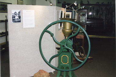
Photograph, 1999
Taken in 1999, the photograph depicts a section of “The Harvest” exhibition held at the Burke Museum between May 1st and June 20th 1999 as part of the Baking Industry Victoria. In the foreground is believed to be an old seed distributor. The grain mill made by B. M. Purshouse in Wolverhampton, United Kingdom, was of special interest during the exhibition. This photograph is of historical and research significance, connecting with various themes such as farming, adapting to diverse environments, and the promotion of settlement in Victoria. The photograph is an example of an exhibition held at the Burke Museum in 1999, demonstrating the communal interest of Beechworth in their farming history. The photograph contains a strong interpretive capacity as it demonstrates the importance of farming to Beechworth and Beechworth's history, revealing the enduring connection between the local community and the surrounding land. The historical and research value of the photograph is further enhanced by the depiction of historical farming machinery, providing a means for future generations to view historical machines used in farming. Colour rectangular photograph printed on photographic paper.Reverse: 2857burke museum, the harvest, exhibition, baking industry, grain mill, b. m. purshouse, beechworth, baking industry victoria, seed, seed distributor -
 The Beechworth Burke Museum
Photograph, 1999
Taken in 1999, the photograph depicts a section of “The Harvest” exhibition held at the Burke Museum between May 1st and June 20th 1999 as part of the Baking Industry Victoria. In the foreground is depicted a seed distributor. The grain mill, which can be seen in the background, was made by B. M. Purshouse in Wolverhampton, United Kingdom, and was of special interest during the exhibition. This photograph is of historical and research significance, connecting with various themes such as farming, adapting to diverse environments, and the promotion of settlement in Victoria. The photograph is an example of an exhibition held at the Burke Museum in 1999, demonstrating the communal interest of Beechworth in their farming history. The photograph contains a strong interpretive capacity as it demonstrates the importance of farming to Beechworth and Beechworth's history, revealing the enduring connection between the local community and the surrounding land. The historical and research value of the photograph is further enhanced by the depiction of historical farming machinery, providing a means for future generations to view historical machines used in farming.Colour rectangular photograph printed on photographic paper.Reverse: 2855burke museum, the harvest, baking industry, baking industry victoria, seed distributor, grain mill, b. m. purshouse, beechworth, exhibition -
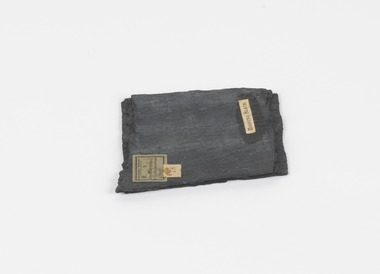 The Beechworth Burke Museum
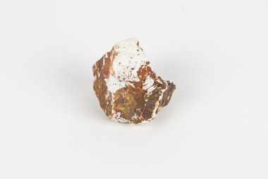
Geological specimen - Slate (Metamorphic), Unknown
This particular specimen was found in the Moorabool Slate quarries in Victoria. The Moorabool Slate quarries was established in the 1860’s by a company of Welshmen with a crew of six who purchased land by the riverside to mine for slate. Under the promise of adding to existing recourses the crew mined the slate which was used for paving and roofing. Slate is a fine-grained, low-grade metamorphic rock that is formed by the transformation of mudstone, shale or sometimes volcanic ash under low pressure and temperatures. It dark colour is due to carbonaceous material or to finely divided iron sulphide. It is believed that Evan Rowlands and Theophilus Williams of Ballarat were the first to discover the slate veins. Slate is a one of the most common natural stones in general use. Being used as paving, flooring, roofing and more. However, its history of being mined in Australia is not common as it is considered that the best places to mine slate is Spain and parts of the United Kingdom. This specimen is part of a larger collection of geological and mineral specimens collected from around Australia (and some parts of the world) and donated to the Burke Museum between 1868-1880. A large percentage of these specimens were collected in Victoria as part of the Geological Survey of Victoria that begun in 1852 (in response to the Gold Rush) to study and map the geology of Victoria. Collecting geological specimens was an important part of mapping and understanding the scientific makeup of the earth. Many of these specimens were sent to research and collecting organisations across Australia, including the Burke Museum, to educate and encourage further study.A somewhat rectangular foliated metamorphic rock composed of quartz, sericite and minerals from the chlorite group that make up the compounds of slate. The rock is dark grey almost black.Geological survey / R S / Loc Moorabool /Slate quarries / 1/4 sheet | 78 | Roofing Slate /burke museum, beechworth, geological, slate, metamorphic, slate (metamorphic), geological specimen, slate specimen, indigo shire -
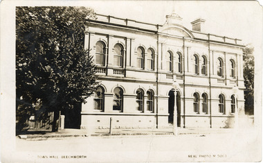 The Beechworth Burke Museum
Photograph - Postcard, Town Hall Beechworth, c1910
Beechworth Town Hall was designed by architects J.J. Coe and Thomas Dalziel and is dated to 1859. The building was made of granite and constructed to local builders Donald and William Fiddes. The original front to the building was replaced by a two story facade in 1889 designed by George Jobbins and built by Thomas Sandham according to a plaque on the front. The Town Hall is remarkable for its vaulted ceilings and columns. Originally the building was used as the Shire Offices but also doubled as a fire station and a courthouse, with still surviving cells underneath. Among the inmates was notorious bushranger Harry Power who was originally transported to Van Dieman’s Land for stealing a pair of shoes. He gained his freedom six years later but spent time in and out of gaol for the rest of his life for a variety of offences including a number of armed robberies. The Town Hall is now home to the Visitor Information Centre which helps visitors with amongst other things, accommodation, tours, event enquiries, and is the commencement point for Precinct walking tours. The Beechworth Town Hall is one of five distinctive granite buildings on Ford Street that comprise the Justice Precinct. It is of considerable historical significance as activity on the site dates from Australia’s gold rush period and was the administrative centre for north-eastern Victoria. The building has seen continual use from 1858 as an important public building and displays many aspects of the history of law enforcement in Victoria. The building is also of substantial architectural significance for its construction from local honey coloured granite, which also showcases early stone masonry techniques and craftsmanship. The Precinct is listed on the Victorian Heritage register and is protected by Heritage Victoria under the Victorian Heritage Act 2017. The buildings are also registered by the National Estate, the National Trust and protected by Indigo Shire Council’s Planning Scheme. Black and White rectangular postcard printed on cardReverse: 1906-1910?beechworth, beechworth town hall, town hall, jj coe, thomas dalziel, granite, beechworth historic building, courthouse, cells, geoge jobbins, thomas sandham, 1859, 1889, walking tours, beechworth historic precinct, historic precinct, harry power, bushranger, australian bushrangers, van dieman's land, transportation, armed robberies -
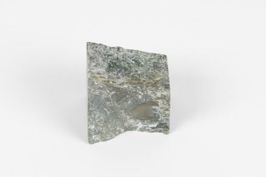 The Beechworth Burke Museum
Geological specimen - Greenstone, Hokitika Jade Company, unknown
New Zealand Greenstone, also called Pounamu is found on New Zealand’s South Island in riverbeds and boulders, and colours vary depending on the source, but always include green tones. It is a form of the mineral nephrite, also known as jade, and is a tough stone with a crystalline structure, made up of calcium magnesium and iron silicate. Its hardness means it is ideal for carving, and has been used for this purpose throughout history, especially by the Maori people of New Zealand. Greenstone features heavily in Maori mythology, and the traditional name for the South Island, Te-Wai-Pounamu, literally translates to waters of greenstone. Wearing of Greenstone pendants with different carvings is practiced by Maori to represent connection to land and ancestors, or to endow the wearer with certain attributes. The sticker on the base of the specimen identifies it as a product of Hokitika Jade Company. The company, which was active in the 1970s, sold jade and greenstone specimens and ornaments. Hokitika, which started life as an 1860s gold rush town, is the origin of most nephrite found in New Zealand, and the centre of the Greenstone carving industry. The object has scientific and research potential as part of the Burke Museum's Geology Collection, and as and example of New Zealand Greenstone. It also has spiritual significance for it's role in Maori beliefs and communities, where it is both traditionally worn and features in mythology. As a valuable stone regularly used in carving and jewellery, it has aesthetic significance. Sticker on base: "N.Z. Greenstone/ a product of/ Hokitika Jade Coy."geological specimen, geology, geology collection, burke museum, beechworth, new zealand, greenstone, hokitika, nephrite, jade -
 The Beechworth Burke Museum
Geological specimen - Montmorillonite
Montmorillonite is a type of clay composed of aluminium silicate that forms very small particles that are not well-bonded to one another. This is why it is so soft. When in the presence of water, all types of clay swell. Montmorillonite swells even more than most types of clay, which is why it is often chosen over other types of clay in its practical uses. Montmorillonite has many different practical uses, including in the mining industry, as a soil additive, as a sealant, as a desiccant to draw water out of the air, to clean ponds, to make kitty litter and in cosmetics. Montmorillonite is a common mineral and, despite being named after Montmorillon, France, can be found all over the world, including many deposits in Australia. It is not known where this particular specimen originates from. Montmorillonite is an economically and socially significant material with a wide variety of uses. Having samples of common and important minerals allows collections, like the Burke Museum, to have a more complete view of the land on which they are located, and therefore a more complete view of heritage. This specimen is part of a larger collection of geological and mineral specimens collected from around Australia (and some parts of the world) and donated to the Burke Museum between 1868-1880. A large percentage of these specimens were collected in Victoria as part of the Geological Survey of Victoria that begun in 1852 (in response to the Gold Rush) to study and map the geology of Victoria. Collecting geological specimens was an important part of mapping and understanding the scientific makeup of the earth. Many of these specimens were sent to research and collecting organisations across Australia, including the Burke Museum, to educate and encourage further study.A solid tennis-ball sized chunk of aluminium silicate clay. It is primarily white, accented with orange and brown.burke museum, beechworth, geological, geological specimen, clay, montmorillonite -
 The Beechworth Burke Museum
Photograph - Lantern Slide, c1900
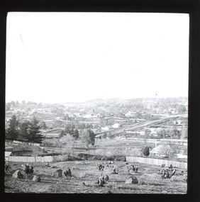
... rights, use of Crown land and the farming of land that wasn't... rights, use of Crown land and the farming of land that wasn't ...Miners from Snake Valley lobbied the Victorian Government in 1855 to make land available for sale for farming purposes as an alternative occupation and income for people who wished to stay in the region but move away from gold mining. A secondary motivation was to increase the supply of fresh produce and decrease prices of items that otherwise needed to be transported from Melbourne or other regions. Forty-three country lots were initially offered in the Three Mile area, ranging in size from two to ninety acres and costing from £1 to £3 per acre. An additional eighty-five country lots were auctioned later in the year, in addition to many smaller suburban lots. More lots were offered than sold, initially, but this represented conditions of sale requiring the total purchase cost up front which many people interested in purchasing could not afford, especially as land purchased for farming would accrue substantial additional costs for clearing and labour before becoming productive. Further lobbying activities and the election of parliamentary members sympathetic to the cause took place through the 1850s. Ovens Parliamentary Member, Daniel Cameron, was re-elected in 1856 on a platform of surveying the land for public selection with deferred payment options. Land reform remained an issue in the area through the 1850s and early 1860s, impacting broader decisions in the new State of Victoria relating to voting rights, use of Crown land and the farming of land that wasn't always suitable for the purpose. This photograph depicts Beechworth in approximately 1900, after several waves of land sales resulted in increasingly levels of development. Lantern slides, sometimes called 'magic lantern' slides, are glass plates on which an image has been secured for the purpose of projection. Glass slides were etched or hand-painted for this purpose from the Eighteenth Century but the process became more popular and accessible to the public with the development of photographic-emulsion slides used with a 'Magic Lantern' device in the mid-Nineteenth Century. Photographic lantern slides comprise a double-negative emulsion layer (forming a positive image) between thin glass plates that are bound together. A number of processes existed to form and bind the emulsion layer to the base plate, including the albumen, wet plate collodion, gelatine dry plate and woodburytype techniques. Lantern slides and magic lantern technologies are seen as foundational precursors to the development of modern photography and film-making techniques.This glass slide is significant because it provides insight into Beechworth's built environment and infrastructure in the early Twentieth Century, around the time of Australia's Federation. It is also an example of an early photographic and film-making technology in use in regional Victoria in the time period.Thin translucent sheet of glass with a square-edged image printed on the front and framed in a black backing. It is held together by metal strips to secure the edges of the slide.burke museum, beechworth, lantern slide, slide, glass slide, plate, burke museum collection, photograph, monochrome, indigo shire, north-east victoria, farming, squatters, miners, agriculture, land-clearing, land reform, daniel cameron, land sales, three mile, snake valley, tarrawingee -
 Orbost & District Historical Society
poison pot, Smith, R. & E, 1940's
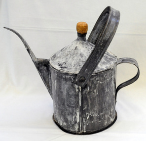
This item was used on P.C. Toby Nixon and Grace Nixon's farm, "Rolling Downs" at Bete Bolong. During WW11 the farm grew carrots, red beet, cabbages, beans and maize. Because of labour shortages the government built a Prisoner of War Camp on Russell's Hill. The manager, Dick Northrope, used three Italian prisoners to frill ring small trees and shrubs between crop harvesting. The introduction of ‘frill ringing’ and poisoning with arsenical tree killers in the 1940's and 1950's helped reduce the amount of labour required and trees on more country were treated. This enabled the hill country at Bete Bolong to become more productive. The dead trees and shrubs were later cleared by Erle Broome's D7 caterpillar bulldozer. This was the first big area of 230 acres to be cleared in the Orbost district. Soon after entering World War 11 Australia was asked by Britain to accept and guard large numbers of 'enemy aliens' and prisoners of war. The British government felt that it could not afford to feed large numbers of prisoners and it was believed that once in Australia the internees would have no chance of escape. Eager to show solidarity with Britain's cause, Australia readily agreed and decided to place the prisoners in a number of different camps scattered around the country and guard them with reservists and soldiers too unfit to serve overseas. There was an internment camp at Bete Bolong, Orbost. This item is an example of an item used by the Italian P.O.W.'s residing there. It is also an example of an agricultural tool not commonly used today.A galvanized iron watering can which has been used to hold poison for ring barking trees (possibly arsenic). It has a narrow spout. There is a handle at the back and a folding handle on the top. The top is conical with an opening for a cork. agriculture prisoner-of-war-camp tree-removal land-clearing -
 Orbost & District Historical Society
map/poster, Victorian Government Printer, 22.4.1926
The Department of Crown Lands and Survey was originally established in 1857 as part of the Board of Land and Works. In 1964 it ceased to be controlled by the Board. The Department functioned for almost twenty more years before being combined with other Ministries to form the Department of Conservation, Forests and Land. It was responsible for the management of the State's Crown land and pastoral estates. This map was used by Don Mehlert after 1928. The VERMIN AND NOXIOUS WEEDS ACT 1928 was an Act to consolidate the Law relating relating to Vermin and Noxious Weeds. E. J. E. G. Pemberton who published this poster was Superintendent of Field Staff, Dept. of Lands and Survey. This map and posters are significant records of early settlement history in Murrangower, between Cabbage Tree and Orbost,A paper map of Murrangower showing settlement subdivisions. This is glued onto the back of four overlapping cloth poster of "Notices of Vermin Destruction". All print is black."DON MEHLERT" in black pen. Pike's block shaded in blue. School site marked in blue pencil. on poster "MURRANGOWAR" along side.map-murrangower poster-vermin-and-noxious-weeds murrangower-settlement -
 Orbost & District Historical Society
book, The Curlip - P.O.W.Camp Bete Bolong, Vic. 1943-1946, August 2007
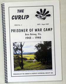
This is Issue No. 5 of "The Curlip". The magazine is a compilation of research from a trip by the Orbost & District Historical Society to Bete Bolong. The Bete Bolong Prisoner of War Camp was located on the south side of the Buchan - Orbost Rd. From November 1943 to November 1945, Italian prisoners of war were based at Bete Bolong, cultivating maize, peas, beans and other vegetables on local farms. Unlike other 'farming' prisoners of war, those at Bete Bolong did not live with the farming families, but at a Prisoner of War Control Centre on Crown land overlooking the Snowy River Flats. About fifty Italian prisoners lived at the centre, along with an Australian Military Force staff of approximately seven people. The prisoners were driven to and from the farms each day. Three of them apparently simply swam across the river to work. They worked a six day week, with Sundays off. Although they were provided with rations, both prisoners and staff maintained vegetable and flower gardens. They were also skilled at cooking 'anything' they could catch, and at making illegal "grappa". Very few of the Italians were experienced farm workers. Some of them used their skills to make things for the families they worked for; a cabinet-maker made furniture , a cobbler made shoes, etc. They interacted with the local community and, although they were not supposed to go within one kilometre of town, some were found at local dances on Saturday nights. As recreation the prisoners were allowed to walk along the road to the west of the camp. Local people from both sides of the river could hear them sing as they walked. The prisoners also helped to construct an 'ant bed' tennis court on a property adjacent to the centre. Although now overgrown, the site of the tennis court can still be discerned as a flat area above the site of the centre. (ref./vhd.heritagecouncil.vic.gov.au)This item is a useful reference tool on the history of the Prisoner of War Camp at Bete Bolong, Orbost.A spiral bound book with a clear plastic cover. On the front is a coloured photograph of a view from the site of the P.O.W. camp at the intersection of Bete Bolong and Buchan Roads at Bete Bolong. Above is the title "Prisoner of War Camp Bete Bolong, Vic. 1943-1946" in black print on a white background. p.o.w.-camp-orbost ww11 bete-bolong -
 Orbost & District Historical Society
black and white photograph, Empire Post Cards, C 1940s
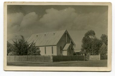
"The first Presbyterian Church service was conducted at the Orbost Station Homestead in 1885, during a visit by Sir William Clarke, who was accompanied by two ministers. The organist was resident Grace Jennings Carmichael. Services were later held in Mr J. W. Borland’s shop and the Mechanics Hall. In 1887, the land on which the church now stands was purchased from Mr James Hossack snr, for £50 ($100). The trustees were Mr John, Peter and Hugh Cameron, Mr John A Watt and Mr James Hossack Jnr. Timber from Richardson’s Tabbara Mill was used by builder Mr R. P. Cameron and at a cost of £311.3.7 ($622) the church was opened January 9th 1898." (from Newsletter 90 Margaret Smith) In 1928 the Sunday School hall was added to the church. Mr R.P. Cameron was the contractor for both the manse and the church. The first communion service was held on July 17 1892. the Presbyterian Church was commenced in Orbost in 1855 when the Reverend Chas Attwood was settled in pastoral charge.This is a pictorial record of the Presbyterian Church in Orbost as it was in the mid 20th century. It is now the Orbost Uniting Church hall, known as St Andrews Hall,A black /white postcard photograph of the Orbost Presbyterian Church, a wooden structure with a wooden picket fence at the front and trees on right and left sides. on back - " H Gap, Presbyterian Church Orbost"presbyterian-church-orbost religion -
 Orbost & District Historical Society
black and white photograph, 1913
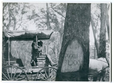
... land-use history. Old survey trees serve as one of the few ...When marking a boundary for a registered plan, a surveyor would place “Reference Marks” with a stated bearing and distance to a boundary corner. These trees were typically marked by cutting the bark of the tree in a shield or blaze. Until July 1886, surveyors were only able to use trees as reference marks to boundary corners. After July 1886 surveyors were able to use “permanent marks” which were either a glass bottle, gas pipe or iron bolt (for homestead surveys only). This photograph shows the reference tree, 83 miles from Marlo via the original surveyed road v ia Sydenham Inlet and Tamboon, south of Mount Drummer to the New South Wales border - now the Princes Highway.This is a pictorial record of an old survet tree. Knowledge of their location, abundance and condition not only provide important insights to past survey practice, but also provide a lasting legacy of a regions land-use history. Old survey trees serve as one of the few remaining physical legacies of early European land settlement history.A large black / white photograph of a horse and buggy pulled up alongside a reference tree which has notches and markings of Roman numerals.on back - " Refernce tree 83 miles from Marlo........to N.S.W. Border"survey-tree reference-tree -
 Orbost & District Historical Society
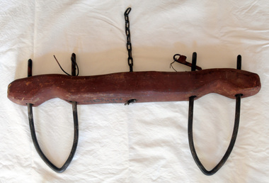
calf yoke, 1920's
This calf yoke is a wooden beam used between a pair of calves to enable them to pull together on a load when working in pairs. This item was made for John Mundy as a child. The original Mundy family moved to a land "selection" at Betebolong in the early 1880's from Buchan. This is an example of a hand-made item commonly used in Orbost on dairy farms in the first half of 20th century.A hand-made wooden yoke painted brown. It has two iron neck pieces and a piece of chain attached in the centre. There are two different locking devices for the necks.calf-yoke rural -
 Orbost & District Historical Society
Weapon - boomerang
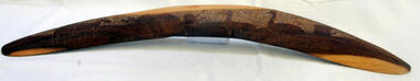
Boomeramgs were necessary tools and equipment for hunting, fishing and warfare, and were one of the very few items that Aboriginals carried with them from place to place. Because many were made from raw natural materials, such as wood, generally only partial remains are found today. The necessary tools and equipment for hunting, fishing and warfare were one of the very few items that Aboriginals carried with them from place to place. Most were used for a multiplicity of purposes. Because many were made from raw natural materials, such as wood, generally only partial remains are found today. This item may be a more modern tourist souvenir.Single piece of wood with fluted upper concave surface, decorated with incised images of a kangaroo in the left quadrant, bullrushes in the central quadrant and two emus in the right quadrant.boomerang, hunting, aboriginal warfare, central australian, arnhem land -
 The Beechworth Burke Museum
Photograph
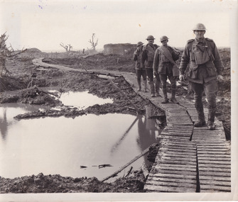
Taken during World War I on the Western Front, this photograph depicts four soldiers dressed in full uniform and kit walking through muddy trenches on wooden duckboards.On the Western Front, the war was fought by soldiers in trenches. Trenches were long, narrow ditches dug into the ground where soldiers lived. They were very muddy, uncomfortable and the toilets overflowed. These conditions caused some soldiers to develop medical problems such as trench foot. There were many lines of German trenches on one side and many lines of Allied trenches on the other. In the middle was no man's land, which soldiers crossed to attack the other side. 'Duckboards' (or 'trench gratings') were first used at Ploegsteert Wood, Ypres in December 1914. They were used throughout the First World War being usually placed at the bottom of the trenches to cover the sump-pits, the drainage holes which were made at intervals along one side of the trench. This made it easier to pump out the pits when necessary. The raised edges of the boards in theory helped protect men's feet from accumulated water; walking along them (especially at night and in the wet) was something of an art as it was easy to lose one's footing and slip or trip on the fequently misaligned sections.Sepia rectangular reproduced photograph on matte photographic paperReverse: 6528/ (A copyright and reproduction notice from the Australian War Museum, printed in blue ink)/burke museum, military album, trench warfare, duckboards, soldiers, ww1, wwi, world war 1, world war i, western front -
 The Beechworth Burke Museum
Photograph
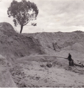
This photograph depicts a man in dark clothing, standing in front of a cut away section of earth. He is undertaking hydraulic sluicing, which involves the use of high powered hoses, in order to cut away the earth which can then be sifted for gold. There is a single tree in the background and the earth contains numerous signs of damage because of the mining. Beechworth become a mining settlement after the discovery of gold in 1852. Gold fever had already spread across Australia's colonies and the American states. Sluicing the landscape for gold, as shown in this photograph, was done by diverting water and washing away the lighter dirt, allowing the gold particles to sift down in to catchments for collection. In Beechworth, there was considerable discontent caused by attempts to restrict water use for sluicing to those with certain 'water rights'. The extensive use of hydraulic sluicing, and the washing away of top soils has continued to impact the surrounds of Beechworth in to the present day. Sluicing as a method for gold mining which was widespread across Victoria during the 1870s. The erosion of the top soil in search of gold has a continuing environmental impact on the landscape and this photograph depicts but one example of this occurring and can provide much information to a researcher interested in understanding the history of gold mining in Victoria. This image of the miner and hose is historically important because it demonstrates the methods of goldmining employed in the later years of the goldrush at Beechworth. It shows how much land is washed away by the use of this technology. The image has good interpretive capacity because it allows researchers to see a different mining technique to what is usually presented. Black and white square photograph on card.reverse: 84-50-3 / 1997 3141 / smdsluicing, goldmining, beechworth, burke museum, miners, gold miners, gold sluicing, environmental impact -
 The Beechworth Burke Museum
Photograph
This photograph depicts four men standing near a large unidentified building. This building is the entrance to a deep lead mine shaft. There is a bridge entering the building, which was used to access the elevator to the shaft. Deep lead mining involved placing large shafts into the ground which miners use to access deeper locations in order to excavate the rocks in the search for lead. Deep lead mining was highly dangerous as roofs could cave in of the soil was loose. Therefore, this particular mining considered to be highly undesirable profession as many miners did not want to work long hours nor risk their lives in the search for lead. Indigo Shire was a large area where deep lead mining took place, and thus the landscape and environment was largely impacted by these mining businesses. The Indigo Shire grew in population and wealth in the early 1850s when people came into this location in the hopes of finding gold and making a fortune. Ultimately, the accessibility and availability of gold and precious metals decreased once the gold reserves dried up and alongside this, the large population moved away. The Ovens was also heavily impacted environmentally as deep mining resulted in the change in land formation.The search for gold is ingrained into the history of Victoria and therefore, images like this one which portray an open cut sluicing site can reveal important information for society and technology for the date when the photograph was taken. This image is of important historical significance for its ability to convey information about the methods used to find gold in Indigo Shire. It also shows a location where deep mining was undertook which provides insight into the impact of deep mining on the environment at a time when it was done. This image is important for current research into the history of Indigo Shire, a region in Victoria's north-east. Therefore, this image has the capacity to be beneficial for research into society and the motivations of those living and working in this region during this period and therefore, has social significance. The Beechworth Burke Museum has additional images relating to deep lead mining and Indigo Shire which can be analysed and studied alongside images like this one.Sepia coloured retangular photo printed on gloss photographic paper.Reverse: 1997, 2510/ A02570/ Deep Lead Mining/ page 94/ 65%/ Burke Museum, Photo 44beechworth, burke museum, indigo shire, deep lead mining, mining, gold, gold mining -
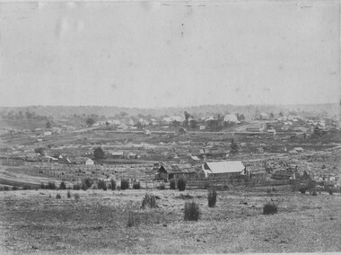 The Beechworth Burke Museum
Photograph, 1865
Taken in Beechworth 1865, this photograph depicts the view of the Spring creek with the Beechworth township in the background. This photograph was taken 13 years after the discovery of Gold at Spring Creek. Within eleven months of the discovery in 1852, over 8000 hopeful prospectors had descended on the region, transforming the seemingly undisturbed land into what a visiting journalist in 1880s referred to as; "A Titan's Field". Huge mounds of earth were churned by hundreds of miners in search for gold, almost every available resource the land had to offer was used for something; even the bark off the gums were stripped to line huts and shafts. By 1857 more than 20,000 people lived in Beechworth, and with this influx the town prospered with the building of numerous churches, banks, schools, shops and hotels along with a prison and hospital.Black and white rectangular photograph. Image is printed on matte photographic paper and is mounted on cardboard.Obverse: NO INSCRIPTION Reverse: BMM6925 / BEECHWORTH FROM SPRING CREEK 1865 beechworth, spring creek, gold rush, titan's field, 1865, prospectors