Showing 10914 items
matching lander
-
 Bacchus Marsh & District Historical Society
Map, Plan of the second portion of the property of Messers Atkins and Clarke situate at Bacchus Marsh 1856
This plan of land allotments for sale indicates part of the property once owned by the Bacchus family in and around the township area of Bacchus Marsh. The Bacchus family sold their property in Bacchus Marsh to John Aitkins and Robert Nalder Clarke in March 1851. Aitkins and Clarke kept the property for a number of years until April 1856 when these allotments were put up for sale.This is a very early land sales plan for agricultural land close to the township of Bacchus Marsh. It therefore provides some clues as to how the early urban development of the township and agricultural development of the nearby area took place. Upon seeing the map in 1911 Bacchus Marsh Express newspaper editor Christopher Crisp wrote "The sale appears to have created the present township, which had a nucleus in earlier times further east", Express, 30 September, 1911, page 3.A single page paper plan showing allotments of land for sale. The subdivided land shown was owned by John Aitkins and Robert Nalder Clarke, but previously owned by the Bacchus Family and was in and around their Manor House (Mansion) property in Bacchus Marsh. This plan shows allotments in the second portion of land to be sold which was located east of the Manor House on the eastern side of the Lerderderg River. The land for sale was made up of 15 allotments. The plan is pasted into a bound volume containing 76 maps or plans in total. BMDHS Loc: AR/B12/S4 Bacchus Marsh Township and Nearby Districts Maps Volume In-house Digital copies: BMDHS, Computer Network: Maps\Bacchus Marsh Township and Nearby Districts Maps Volumebacchus marsh victoria maps, bacchus family, land sales, manor house bacchus marsh -
 Clunes Museum
Document - LEASE
LICENCE ISSUED TO MR. PATRICK KEIRCE [INCORRECT SPELLING KIERCE] ON 29TH AUGUST 1870PHOTOCOPY OF LEASE OF LANDASSISTANT COMMISSIONER OF LANDS AND SURVEY. BALLARAT.local history, document, lease, kierce, michael mr. -
 Clayton RSL Sub Branch
Photograph, Reinforcements from 7/37 Battalion
HMAT Ballarat was torpedoed by a German submarine in the english channel. All 1720 souls on board survived the torpedo attack. HMAT Ballart departed from Melbourne on 19.2.1917.photo of troops on landReinf 7/37 Batt. A.I.F Torpedoed on HMAT Ballarat on Anzac Day 25th April 1917 These troops when torpedoed upheld the best traditions of the race and their conduct was beyond praise. They were the recipients of the warmest praise from his Majesty the King; General Birdwood K.S.C.I. KCMG. CB. CIE, DSO. and the Commonwealth High Commissioner, The Hon Andrew Fisher. -
Whitehorse Historical Society Inc.
Document, Course family, 2008
The Course Family - pioneers of Forest Hill. Talk given by Pat Richardson at a Whitehorse Historical Society general meeting, 9 February 2008.The Course Family - pioneers of Forest Hill. Talk given by Pat Richardson at a Whitehorse Historical Society general meeting, 9 February 2008. With genealogical chart and documents relating to the family's English origins, migration and land holdings.The Course Family - pioneers of Forest Hill. Talk given by Pat Richardson at a Whitehorse Historical Society general meeting, 9 February 2008. forest hill, tainton family, fankhauser family, whitehorse historical society inc., course family -
 Bacchus Marsh & District Historical Society
Map, Coimadai Parish Map, County of Bourke. Circa 1890s-1900s
The cadastral Parish of Coimadai, a subdivision of the County of Bourke, lies directly north of the township of Bacchus Marsh. The date of this map is uncertain. T.F. McGauran the person who made a photo-lithographic copy of the map was in charge of photo-lithography at the Victorian Department of Lands and Survey in the late 19th century until about 1910.A single page paper map showing the map for the Parish of Coimadai in the County of Bourke. A cadastral map showing parish boundaries and land ownership. A rectangle shaped area is missing from the centre of the map due to a tear or deliberate excision. The map is pasted into a bound volume containing 76 maps or plans in total. High resolution digital image stored on BMDHS computer network. Photo-lithographed at the Department of Lands and Survey, Melbourne by T.F. McGauran 26.8.[??] NOTE. Photo litho from L.P showing temporary surveys and occupation of land prepared for departmental use onlybacchus marsh region parish plans, coimadai parish maps, coimadai parish plan -
Whitehorse Historical Society Inc.
Article, Rezoning outrage, 22/09/1992 12:00:00 AM
Nunawading Council outraged by State Government's shock decision to immediately rezone land in the Eastern Arterial Road corridor without public consultation.Nunawading Council outraged by State Government's shock decision to immediately rezone land in the Eastern Arterial Road corridor without public consultation. The decision means the land set aside for the Eastern Arterial Road will be immediately rezoned to public open space by ministerial amendment jeopardising any future moves to construct the entire freeway. Council are considering Supreme Court action to stop the rezoning.Nunawading Council outraged by State Government's shock decision to immediately rezone land in the Eastern Arterial Road corridor without public consultation. local government, city of nunawading, eastern freeway, koonung mullum forestway association, mullum mullum creek -
Whitehorse Historical Society Inc.
Document, Details of Title Changes - 2 Gordon Crescent, Blackburn
Details of title changes of 2 Gordon Crescent, Blackburn.Details of title changes of 2 Gordon Crescent, Blackburn. Original owner of land was John Woods in 1855. He resold to George Coppin who resold to Freehold & Investment Banking Co. of Australia.Details of title changes of 2 Gordon Crescent, Blackburn. gordon crescent, blackburn, no. 2, woods, john, coppin, george seth, freehold investment and banking company of australia ltd, australian deposit and mortgage bank -
Whitehorse Historical Society Inc.
Letter - Correspondence, Letter re land tax, Strathdon, 4/08/1961 12:00:00 AM
Letter from State Land Tax office to Mrs Mary Matheson re land on Springvale Road.Letter from State Land Tax office to Mrs Mary Matheson re land on Springvale Road.Letter from State Land Tax office to Mrs Mary Matheson re land on Springvale Road.matheson, mary, strathdon community -
 Warrnambool and District Historical Society Inc.
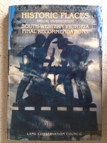
Book, Historic Places of South West Victoria
This is the third in a series of booklets produced by the Land Conservation Council in 1997 (176 pages). Booklets One and Two (1996) contained A Descriptive Report and Proposed Recommendations. The Final Recommendations include information on processes for protection of historic places, lists of significant places in the south-western region and aboriginal historic places. Attached inside the back cover are two maps showing the location of the significant places.This is a useful book as it lists the declared historic sites in the region and researchers will find the information helpful. This is a soft-cover book with a multi-coloured cover featuring a photograph of the Pioneers Memorial, Deep Lead. It has a red-coloured spine and back cover.Front Cover – Historic Places - Special Investigation - South-Western Victoria - Final Recommendations – Land Conservation Council Spine – Historic Places – South-Western Victoria – Final Recommendations – Land Conservation Council Back Cover – Historic Places, Final Rec., code used for retail sales warrnambool -
Whitehorse Historical Society Inc.
Document, Notes on Job. Hone, n.d
Notes on Job Hone's arrival in Victoria in 1850.Notes on Job Hone's arrival in Victoria in 1850, one of the first people to discover gold at Avoca, returned to Box Hill in 1853 and bought land. he assisted in establishing most of the churches in the area.Notes on Job Hone's arrival in Victoria in 1850. hone, job, pioneers -
Whitehorse Historical Society Inc.
Article, Couple give land for park, 21/01/1967 12:00:00 AM
Article from The Age, 21 Jan 1967.Article from The Age, 21 Jan 1967, re Blackburn couple Arthur & Janet Cooke deciding to hand over their house and land to the Council on their death to keep as a sanctuary for birds, plants and flowers.Article from The Age, 21 Jan 1967. hooke, albert arthur, hooke, janet emily, wandinong sanctuary -
University of Melbourne, Burnley Campus Archives
Booklet, The University of Melbourne, The University of Melbourne Institute/Faculty of Land and Food Resources Postgraduate Handbook, 2003-2007
the university of melbourne, institute of land and food resources, faculty of land and food resources, postgraduates, handbook, courses -
 Federation University Historical Collection
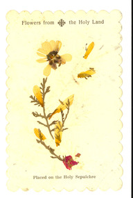
Plant specimen, Flowers from the Holy Land, possibly c1949
This item was located in a book called The English Lakes which was owned by E.C. Holmes [Edward Carter Holmes was the name of my mother's, Elizabeth Mary [Elizabeth] Holmes family's pioneer settler. He arrived in Geelong on the 28th of June, 1849, with his wife Sarah and their first child Frances Harriet as assisted immigrants (people whose passage was subsidised by an assisted immigration scheme) to New South Wales at Port Henry, Geelong in the sailing boat ‘Larpent’. Sarah and Edward arrived two years before his mother, Harriet, arrived as unassisted passenger in Geelong on ‘The Eagle’. 200 of the " Larpent" passengers had been selected in England by Rev John Dunmore Lang whose wish was to encourage the migration of hard-working, God-fearing Protestants to the colony. He sponsored two ships, the "Travancore" and the" Larpent', to bring the settlers to Australia in 1849 with Dr Alexander Thomson, a Sydney Presbyterian minister, ready to receive and settle them. Thomson owned section 10 of the parish of Barrabool known as the Kardinia section — a square mile of undulating land west of Colac, still known today as Larpent. Among the 'Larpent' immigrants were many well-known Ballarat and District pioneers including Armitage, Mercer, Oddie and Scott. For more details about this migration scheme refer to: A thoroughly Protestant emigration: the emigration activities of the Rev. Dr. J.D. Lang / Ian Wynd.2006.] [source: Jane Dyer 2024] Printed card with a pressed botanical specimen glued onto it. Printed onto the card 'Flowers from the Holy Land. Placed on the Holy Sepulchrechatham family archive, chatham, holmes, ec holmes. holy land, relic, botanical, botany, holy sepulchre, botanical specimen -
 Lakes Entrance Historical Society
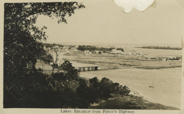
Postcard - First concrete bridge over North Arm Lakes Entrance Victoria, H D Bulmer, 1920 c
First concrete bridge over North Arm swamp land behind buildings on Esplanade low sand dunes on outer barrier Lakes Entrance VictoriaBlack and white postcard of township showing first concrete bridge over North Arm swamp land behind buildings on Esplanade low sand dunes on outer barrier Lakes Entrance VictoriaLakes Entrance from Princes Highwayislands, roads and streets, bridges, township -
 Lorne Historical Society
Map, F W Niven Lithos, The Mountjoy Lorne Estate, 1889
In 1888 a company was formed to acquire and subdivide the land of the Mountjoy Brothers. The land totaled 197 acres and included Erskine House. The land colored red was that of the Mountjoys. The subdivision map was printed in 1889A paper map of the Mountjoy Estate Lorne , showing allotments, with their owners, and naming land use. It has four black and white line drawings , Erskine House, Mountain View’s, the Rapids, Erskine House sea view and Erskine Falls. The map is largely black and white with red and blue colouring. The map is mstuck to brown paper. lorne, subdivision map, erskine house, mountjoy brothers, -
 City of Kingston
Pamphlet - Colour, R. Malcolm Estate Agents et al, Last Chance Land Sale Heritage Estate Cheltenham, c.1994
Sales plan for land in the suburb of Cheltenham, bounded by Chesterville Road and Bernard Street, and incorporating Clendon Court, Tintern Grove and Tintern MewsThis land sale pamphlet illustrates one of the last subdivisions of the century in Cheltenham, incorporating house and land packages. It shows that land sales and subdivision for the area had slowed considerably by the end of the 1900s and that the infrastructure was significantly developed. Colour pamphlet advertising last chance land sale of Heritage Estate Cheltenham. Incorporates a map of the estate bordered by Chesterville Road and Bernard Street, and including Clenton Court, Tintern Grove and Tintern Mews.cheltenham, land sales, estate -
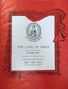 Kew Historical Society Inc
Programme, The "Q" Theatre Guild, The Land of Smiles, 1961
The "Q" Theatre Guild was formed out of the Kew Light Opera Company in 1957. It marked the transition of the company that had initially been directed by Lance Nicholls to one directed by Beatrice Oakley. It continued to perform in the Kew Recreation Hall, but, with its demolition in 1960, and the opening of the new Kew City Hall in Cotham Road, moved its productions to that venue. Productions of the "Q" Theatre Guild included The Geisha (1957), Maritana (1958), They All Do It (1959), Blossom Time (1959), Love's A Luxury (1959), There And Back & The Bohemian Girl (1960), Die Fledermaus (1960), Gay Rosalinda (1961), The Land Of Smiles (1961), Kisses For A Kid & Hansel And Gretel (1961), Die Fledermaus (1962), Monsieur Beaucaire (1964), Macbeath or The Beggar's Opera, and So To Bed.The scrapbook of annotated photographs, programmes, and newspaper reviews of which this item is a part was assembled by Marion Tilley, wardrobe mistress for, and performer in, productions by the Kew Light Opera Company and the "Q" Theatre Guild. It is significant as a remarkably complete document of theatre performances in Kew, Victoria during the 1950s and 1960s. The scrapbook, and the items individually catalogued within it, have artistic and aesthetic significance within the history of performing arts in Victoria in the middle of the 20th Century. They have social significance in that they reveal socio-cultural values and preoccupations during the period. The records also act as a history of arts activities in the Kew Recreation Hall and later in the Kew City Hall as entertainment and community arts and music precincts.Souvenir programme issued by the "Q" Theatre Guild for a performance of Franz Lehar's The Land of Smiles in 1961. The production was performed at the Kew City Hall. The Cast List includes annotations by Marion Tilley. This was the first time that The Land of Smiles had been performed in Melbourne."q" theatre guild, performimng arts, kew city hall, the land of smiles (lehar) -
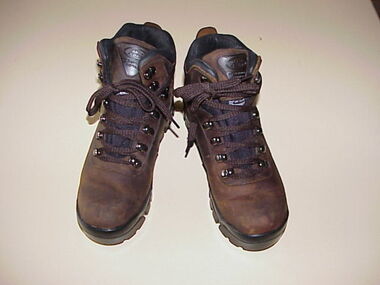 National Wool Museum
Shoes, Womens hiking boots
Par tof the womens casual 'sportwool' uniform for the Winter Olympic games, 2002LAND ROVER GO EVERYWHERE FOOTWEAR Du Pont certified Thermolite Thin insulation LAND ROVER GO EVERYWHERE FOOTWEARfashion, shoes, costume, sport, salt lake city -
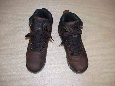 National Wool Museum
Shoes, Mens Hiking Boots
Part of the Mens Winter Olympic Uniform (as worn in the opening ceremony). However, these boots are unused.Pair of mens hiking boots as worn in the Opening Ceremony of the Winter Olympics, Salt Lake City, 2002Land Rover Go Everywhere Footwear Du Pont Certified Thermolite Thin Insulation Land Rover Go Everywhere Footwearfashion, costume, shoes, leather, sport, salt lake city -
Whitehorse Historical Society Inc.
Document, Roberts' recollections, 1/10/2000 12:00:00 AM
On the occasion of 100 years of Federation.On the occasion of 100 years of Federation, John Roberts, former municipal officer (land uses and valuer) at Nunawading, recalls the problems families encountered with the provision of services for subdivisions and shopping in Nunawading in the 1950s and 1960s.On the occasion of 100 years of Federation.roberts, john, water supply, electricity supply, city of nunawading -
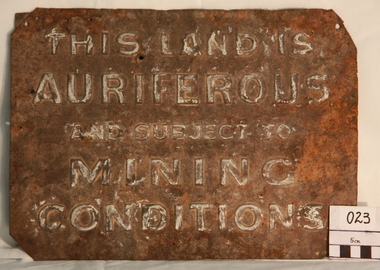 Myrtleford and District Historical Society
Gold Mining Sign
This sign was required to be displayed in the vicinity of gold mining sites. Myrtleford district was known to have had 100 sites within a ten mile radius of the town; the sign was recovered by Charlie McFadyen, a local prospector and fossicker, of some 60 yearsThe sign relates to local gold mining activity, a key source of wealth and employment from 1854 to the late 19th century. Such signs continued to be in use during the period between World War 1 and 2,including the period of the Great Depression.Tin rectangular mining sign embossed with a warningInscription: "THIS LAND IS AURIFEROUS AND SUBJECT TO MINING CONDITIONS"auriferous mining -
 Finnish Society of Melbourne
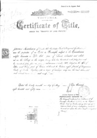
Deed document of Finnish Society of Melbourne, Office of titles Victoria, 1889
The Finnish Society of Melbourne purchased the old Red Robin Hosiery from Nelson Bros. proprietary Limited on the 4th of March 1974. The building was purchased as a home for the Society. On the document there are 9 members as joint proprietors. A trust document was created at the time.Their were joint proprietors. The document was not in the name of the Society. Additional trust document was made at the time.Large document Certificate of Title under the transfer of land staturecertificate of title -
 National Wool Museum
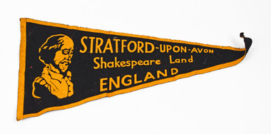
Pennant
STRATFORD-UPON-AVON Shakespeare Land ENGLANDstratford upon avon, england -
 Lakes Entrance Historical Society
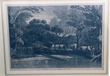
Photograph, Fish, Marie, 1999 c
Photographed from a book illustrationPhotograph of a woodcut depicting an early camp of fishermen on Lake Victoria, Gippsland Lakes, Victoria.Fishermen's Camp, Lake Victoria, Gipps Landvegetation, camping, arts and crafts -
Lakes Entrance Historical Society
Book, McGrath, Michelle, Trestle Bridge, 2005
Research, interpretation and management recommendations for the trestle bridge at Stony Creek, Nowa Nowa, Gippsland, VictoriaConservation and Land Management Culture Analysis Reporttransport, bridges -
 Bendigo Historical Society Inc.
Document - MARKS COLLECTION: PARISH PLAN OF WHITE HILLS
Sepia coloured map showing allotments in Parish of Sandhurst (White Hills) Written on LH side of map town and Suburban Lots White Hills Parish of Sandhurst. Scale is shown in chains. Surveyed by Horage Walker. Photo lithographed at the Department of Lands & Survey, Melbourne by J.Noone, Price 1/-. 6th. January 1865. Map shows Race Course Reserve at top of sheet, Municipal boundary is marked on LH side. Comments re vegetation throughout map. For example, poor soil timbered with Box scrub.on the back--Plan of Land White Hills Sandhurstbendigo, planning, white hills parish map, horage walker, j noone, department of lands and survey, -
 Orbost & District Historical Society
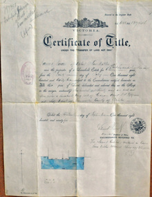
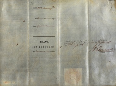
certificate of title, 1895
This certificate of title is a record of interests and rights affecting land owned by James Nixon of Orbost, sawmiller. James Nixon was a significant and influential citizen of Orbost's early years.A certificate of title of land -black print on white paper. It has a red stamp dated -"23 Sep 1895" overstamped with "fee 20/-" in black. It is signed "Edward Davies(?) Duncombe (?). at the bottom is a diagram of the block shaded in blue ink.nixon-james land certificate-of-title -
 Orbost & District Historical Society
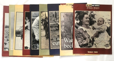
magazines/booklets, Our Land/Our Century, 1999
The Weekly Times was first published on September 11, 1869. In September 1875, The Weekly Times absorbed two other Melbourne-based rural publications, the Economist and Town and Country.In 1892 the Daily Telegraph company sold its buildings and mastheads to the Herald group, which has published The Weekly Times continuously since. In 1902 The Herald and Standard Newspaper Company Ltd changed its name to the present Herald and Weekly Times. These booklets were published as souvenir magazines to "celebrate 100 years on the land". These magazines are records of the rural history of Victoria.Nine of ten Weekly Times souvenir booklets/magazines titled Our Land, Our Century 1900-1999: Celebrating 100 Years on the Land. They contain pictures and stories of events related to rural Australia. Each edition covers ten years from 1900 -1989. The issue, 1990 -1999 is missing.magazine weekly-times souvenir rural-history -
 Whitehorse Historical Society Inc.
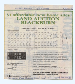
Article, Land Auction, Blackburn, 7/09/1994 12:00:00 AM
old Blackburn Advertisement in the Nunawading Gazette 7 September 1994Advertisement in the Nunawading Gazette 7 September 1994 for auction of the old Blackburn East Primary School (closed December 1993) land. Auction 25 September 1994. Greenwood Estate, Nicoli Street.old Blackburn Advertisement in the Nunawading Gazette 7 September 1994 land subdivision, bindy street, blackburn south, vicki street, sandra street, blackburn east primary school, no. 4800 -
 Federation University Historical Collection
Document, Victoria: Land Purchase, Edward Ager Wynne, 1856, 23 January 1856
.1 Document outlining the purchase of Lot No. 39: 16 acres, 3 roods, 9 perches situated in the County of Talbot, Parish of Glendaruel by Edward Ager Wynne of Melbourne for the sum of Seventeen Pounds Thirteen Shillings .2 Document outlining the purchase of Lot No. 30: 50 acres, 2 roods, 38 perches situated in the County of Talbot, Parish of Glendaruel bu Edward Ager Wynne of Melbourne for the sum of Fifty Pounds Fourteen Shillings and Nine Pence Both documents were witnessed by Major-General Edward Macarthur the Senior, Officer in Command of Our Land Forces Thick cream paper, hand writtenDate: 23 January 1856 Signature: E Macarthur - Major General of Our Land Forces Official Seal county of talbot, parish of glenaruel, acres, roods, perches, edward ager wynne, major-general, edward macarthue, land purchase agreement