Showing 25571 items matching "plenty-township-estate"
-
 Eltham District Historical Society Inc
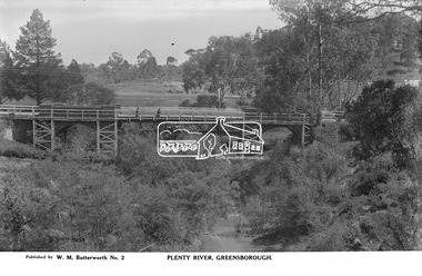
Photograph, The Rose Stereograph Company, Plenty River, Greensborough, c.1939
View looking northwest along the Plenty River towards the original bluestone Greensborough Bridge (since demolished). A timber pedestrian footbridge added after construction is visible with two people crossing. In the distance is a wide flat verge, now present day Carter Reserve and on the far side seven men digging and a set of terraced steps dug out in the earth bank. Present day Pioneer Reserve is to the right of the river in foreground. This glass plate negative was used to manufacture postcards (1:1 printing) for commercial sale by the Rose Sterograph Company and its subsidiaries. George Rose founded the Rose Stereograph Company in 1880 and was joined by Herbert (Bert) Cutts in the early 20th Century. The pair formed a lifetime working partnership and strong personal friendship. Assisted by George’s two sons, Herbert George and Walter, and later by Neil Cutts, the Rose Stereograph Company continued its operations for more than 140 years. The company was initially built on stereographs, but as cinema took over and stereographs fell out of fashion, the Rose Stereograph Company developed Australia’s first commercially viable photographic postcard business. Specialising in postcards of iconic historical moments and significant landmarks, The Rose Stereograph Company became a staple of the Australian travel industry.This remarkable collection of glass plate negatives, transparencies, and postcards – arguably Australia’s most significant photography collection outside of public hands – has been passed down through the generations, surviving war, relocation, and the harsh Victorian climate. The historic Rose Stereograph collection is the culmination of George Rose’s dream of capturing and preserving precious moments in time and remains the legacy of the Rose and Cutts families. It is with great sadness that the Cutts family says goodbye to a collection that spans five generations and 140 years. The Cutts family understands that for these historically important pieces to rest with one family is to deny others the pleasure of their custodianship.Glass Plate Negative Size: 9 x 14 cmPlenty River, Greensborough, Published by W. M. Butterworh No. 2postcard, travel, rose stereograph company, glass plate negative, greensborough, carter reserve, footbridge, greensborough bridge, main road, plenty river, w. m. butterworth, pioneer reserve, construction, peter and elizabeth pidgeon collection -
 Eltham District Historical Society Inc
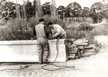
Photograph, Construction of Lower Plenty Bridge, Main Road, c.August 1966, 1966
Black and white photograph of construction of new bridge, Main Road, Lower Plentybridge construction, main road, lower plenty, plenty river, bridges -
 Eltham District Historical Society Inc
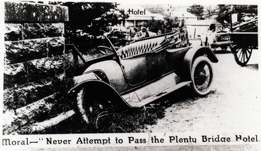
Photograph, Moral - "Never attempt to pass the Plenty Bridge Hotel"
Black and white photograph of a newspaper story about an accident at Lower Plenty Bridgelower plenty, bridge, main road, lower plenty bridge, transport, automobile, accident -
 Bacchus Marsh & District Historical Society
Map, Maddingley Township, Parish of Parwan, 1880s
This map is dated Sept. 6th 1856. However places in the township of Maddingley which did not appear until the late 1880s such as the Bacchus Marsh Railway Station and line are shown on this map in their correct locations. This suggests the map has been derived from an earlier map. An earlier date of 1843 with a surveyor's name preceding it can also be seen on the map. The map is important because it indicates the location and dimensions of early but now discontinued use of land such as the showgrounds and police paddock and a site reserved for the Church of England which was not ultimately used for a permanent church. A single page paper map showing land allotments, streets, rivers, creeks, park lands, the railway line and Bacchus Marsh railway station in the township of Maddingley. The map is pasted into a bound volume containing 76 maps or plans in total. Bottom of Map: Surveyor-General's Office, Melbourne, Sept 6th, 1856bacchus marsh victoria maps, maddingley victoria maps, land use, maddingley victoria history -
![The Township of Walhalla / [by] Nicholas Caire, circa 1876](/media/collectors/550653872162f11fb04854aa/items/57825a89d0cdd1176ce3295a/item-media/57825aefd0cdd1176ce34515/item-fit-380x285.jpg) Kew Historical Society Inc
Kew Historical Society IncPhotograph, Anglo-Australasian Photographic Company, The Township of Walhalla, c. 1876
Nicholas Caire was born on Guernsey in the Channel Islands in 1837. He arrived in Adelaide with his parents in about 1860. In 1867, following photographic journeys in Gippsland, he opened a studio in Adelaide. From 1870 to 1876 he lived and worked in Talbot in Central Victoria. In 1876 he purchased T. F. Chuck's studios in the Royal Arcade Melbourne. In 1885, following the introduction of dry plate photography, he began a series of landscape series, which were commercially successful. As a photographer, he travelled extensively through Victoria, photographing places few of his contemporaries had previously seen. He died in 1918. Reference: Jack Cato, 'Caire, Nicholas John (1837–1918)', Australian Dictionary of Biography.An original, rare photograph from the series 'Views of Victoria: General Series' by the photographer, Nicholas Caire (1837-1918). The series of 60 photographs that comprise the series was issued c. 1876 and reinforced a neo-Romantic view of the Australian landscape to which a growing nationalist movement would respond. Nicholas Caire was active as a photographer in Australia from 1858 until his death in 1918. His vision of the Australian bush and pioneer life had a counterpart in the works of Henry Lawson and other nationalist poets, authors and painters.‘The Township of Walhalla’ : Views of Victoria (General Series) No.37 : Albumen silver photograph | Photo on card with Title and Description on reverse | Mounted 24 x 30 cm; Photo 12 x 17 cm.On Reverse: ‘This romantic Township is situated near Stringer’s Creek in Gipps Land, not far from the celebrated Baw-Baw Mountains. The Long Tunnel Gold Claim has proved a great source of wealth to this small out-of-the-way place, yielding sometimes between 2,000 and 3,000 ounces of gold per month. The population, which is mostly a mining one, reaches nearly 2,000 inhabitants, and are scattered about among the creeks and gullies of the neighbourhood. Until recently, the road traffic was limited to pack-horses, in consequence of the precipitous hills which surround the Town.‘nicholas caire (1837-1918), walhalla, landscape photography -
 Glenelg Shire Council Cultural Collection
Photograph, Photograph - Lighthouse Estate, 1952
Port of Portland Authority ArchivesFront: Lighthouse Estate 25-9-52. Houses on lots five and six. Printed, bottom centre. Back: Purple PHT Stamp 1/1 19 59 52, in black ink.port of portland -
 Otway Districts Historical Society
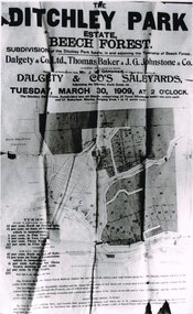
Photograph, Knox Collection, Sale of the Ditchley Park Estate, Beech Forest, 1908
Commercial realities and bushfires caused the Beech Forest community to re-establish itself around the railway station, away from Gardner Hill. This caused John W. Gardner to subdivide his land on the north side of the railway station. One subdivision was created near the Ditchley railway station on the old racecourse site, and another of 25 allotments forming what became Southorn Street. There were very few takers for these lots nor any buyers for the Ditchley subdivision.Photocopy. 260mm x 159mm. An advertisement for the sale of the Ditchley Park Estate, Beech Forest. Under instructions from Mr. J.W. Gardner Dalgety & Co. Ltd. will sell the subdivision of the Ditchley Park Estate on Tuesday, March 30, 1909, at 2 o'clock. A map of Beech Forest township and the Ditchley Park Estate is attached, as are the terms of sale and a description of the area.. beech forest; ditchley park; land sale; advertisment; -
 Buninyong & District Historical Society
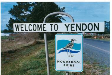
Photograph - Original Photograph, Mr. C.J. Brooks, Yendon township sign, September 1995
Social, historicalYendon township sign taken in September 1995 showing the Moorabool Shire signage of that timeColour photo, Welcome to Yendon Sign on the Western outskirts of the townshiproad signs, yendon, moorabool shire, streetscape -
Whitehorse Historical Society Inc.
Article, Blackburn : a model township, 1889
Description of Blackburn as a model township including a lake, ravine etc.Description of Blackburn as a model township including a lake, ravine etc.Description of Blackburn as a model township including a lake, ravine etc.blackburn model township, blackburn lake -
Stawell Historical Society Inc
Map, Parish of Stawell, County of Borung, Stawell Township, Sheet 1, 1879
Parish of Stawell, County of Borung, Stawell Township, Sheet 1stawell -
 Falls Creek Historical Society
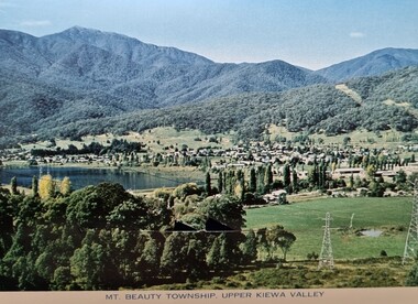
Postcard - Mount Beauty Township
These photographs were taken in and around Mount Beauty and the Kiewa Valley by Samuel Keith Pearce and printed for him as a foldout postcard by NuColor Vue. The postcards state they were printed for S. K. Pearce Pty. Ltd of Tawonga and Mount Beauty. Samuel Keith Pearce was born on 24 June 1917 in Armadale, Victoria. By the late 1940s he owned the Mt Beauty Supermarket, Newsagency, Drapery and Hardware store at Mount Beauty and also a store at Tawonga in partnership with his brother Gordon Cathew Pearce. For some time, they operated as Pearce Brothers. In the early 1960s Keith also opened a mini mart In Falls Creek. As well as being a keen photographer and an astute businessman, Keith Pearce was a well-known identity in the Kiewa Valley, making many contributions to the development of the area over a long period. This included serving as a member of the Bright Shire Council for many years. He worked hard to promote the interests of the Upper Kiewa Valley. As a sign of recognition and appreciation for his contribution to the community, the park opposite the grocery store in Mount Beauty was named the SK Pearce Gardens in his honour. Samuel Keith Pearce died on 7 July 1994 in Mount Beauty, Victoria Mount Beauty was originally established by the State Electricity Commission of Victoria to house construction workers from the Kiewa Hydroelectric Scheme in 1949,[2] passing to the control of the local shire council in 1967 after construction was completed. The town is a launching point for trips to the Falls Creek ski resort, and to the Bogong High Plains. This collection of postcards and images is significant because they were commissioned by a highly successful businessman in Falls Creek, Victoria.A colour image of the township of Mount Beauty in the Upper Kiewa Valley.mt. beauty, kiewa hydroelectric scheme, falls creek, bogong high plains -
Glen Eira Historical Society
Album - Photograph Album, Beauville Estate Album, 2001
Originally labelled "Beauville Estate, Established 1936, Still Thriving 65 years on, 10th March 2001", the Beauville Estate Album contains colour photographs of houses in the Estate. They were taken around the time of the Beauville Estate’s 65th Heritage Celebration held on 10/03/2001 and donated to the Caulfield Historical Society shortly afterwards. Photographer Bev Baxter. Glen Eira’s Heritage Management Plan by Andrew Ward (1996) Vol 2 p78 states that by the end of 1934, the first 3 houses had been built in this housing estate.City of Glen Eira’s Heritage Management Plan Vol 2 p79 (p84 of the pdf version) – HO12 Beauville Estate and environs, Murrumbeena: The Beauville Historic Area is important at the State level as the first large housing estate undertaken by the AV Jennings Construction Co, later Jennings Group Limited, Victoria’s largest home builder. It is important also as a very early estate development incorporating a range of features other than houses and including made roads, shops and recreation facilities. In this respect it was the forerunner of the comprehensively planned housing estate of the post war era. The estate is distinguished by its aesthetic values, as is the earlier and comparable Hillcrest Estate, which are formed by a combination of restrained diversity in house styles, with the exception of no. 30 in the emerging International style, and by a landscaped garden environment.Colour photographs of house exteriors, as well as parks and tennis courts on the Beauville Estate. murrumbeena, houses, beauville avenue, architectural styles, 1930's, inter war style, a.v. jennings, av jennings, jennings, brick houses, beauville estate, murrumbeena road, lindsay avenue, gloucester court, dalny road, a v jennings construction co, beauville estate heritage area, glen eira city council, architectural features, plans, shops, residential development, tennis courts, housing estates, builders, building regulations, local government, commercial development, history, maps, photographs, commercial establishments, jennings group limited, land subdivision, gardens, beauville historic area, sir albert victor jennings -
 Orbost & District Historical Society
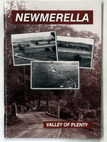
book, Newmerella Valley of Plenty, 2010
This is a 2nd edition of an earlier print, 1978. It has been revised and edited by John Phillips for the Orbost & District Historical Society in 2010. Harry Grosvenor was the headmaster at Newmerella School from 1962 to 1972. Harry was deeply involved in the 1978 publication by the Newmerella Progress Association called: Newmerella - Valley of Plenty. The book is a pictorial history of the early Newmerella district ( west of the Snowy River ).This is a local history book written by Harry Grosvenor a local author.A paperback book, titled Newmerella Valley of Plenty. The front cover is brown with white text and has three b/w photographs of the Snowy River flats as sen from the Newmerella hill. One is a photograph of the railway line with a steam train on the rail viaduct. newmerella-history -
 City of Kingston
Pamphlet - Colour, Stillwell and Co, The Hill Estate Highett Great Subdivisional Auction Sale, 1917
Sales plan for land in the suburb of Highett, bounded by Point Nepean Road and incorporating Sandford Street, Turner Road, Alfred Street, Peace Street and Tennyson Street. .The developing urban area of Highett within the City of Kingston. This land sale pamphlet illustrates the subdivision of land within the municipality and the changing demographic of the district as new houses are constructed.Colour pamphlet advertising subdivisional auction sale of the Hill Estate Highett. Incorporates a map of the estate bordered by Point Nepean Road and encompassing Sandford Street, Turner Road, Alfred Street, Peace Street and Tennyson St. Handwritten in grey pencil on reverse: Hill Street / Jamieson Handwritten in blue pencil on reverse: The Hill Estate Handwritten in blue pencil on subdivision map: [tick] [on majority of properties marked on map]highett, land sales, estate -
 Eltham District Historical Society Inc
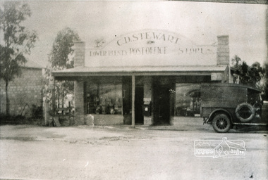
Photograph, Lower Plenty Post Office and store
Black and white photograph of early view of old Lower Plenty Post Office and storelower plenty, post office, shops, main road -
Clunes Museum
Plan - TITLE PLAN, DEPARTMENT OF LANDS AND SURVEY, TOWNSHIP OF GLENGOWER
1 PAGE PLAN OF THE TOWNSHIP OF GLENGOWER COUNTY OF TALBOT (11 COPIES) DRAWN AND REPRODUCED AT THE DEPT. OF LANDS AND SURVERY MELBOURNE VICTORIA NOVEMBER 1954 PRICE 2/-parish of glengower, title plan of glengower -
 City of Whittlesea
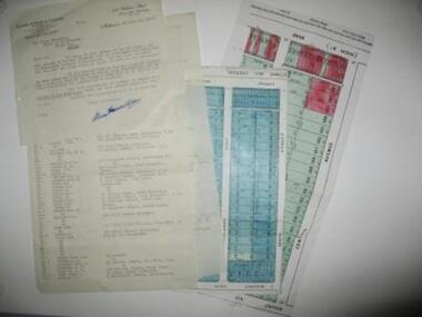
Document - Correspondence, Station Entrance and Railway Platform Estate, 1937
Letter from Ellison, Hewison & O'Collins Solicitors, Melbourne to the Shire of Whittlesea in reponse to a request for the names and addresses of the purchasers of blocks of land on the Station Entrance Estate and Railway Platform Estate, Thomastown. Both estates where originally subdived and sold in the mid 1920s. The collection includes a letter, a list of owners and their address details and the lot they own, and plans of both estates, which have been cut out of the original estate sale posters. Streets include High Street (Epping Road), Mount View Road, Pleasant Road, Central Avenue, Highlands Road and Main Street, ThomastownLetter, paper 3 pages, 2 plans. Letter from Ellison, Hewison & O'Collins Solicitors, Melbourne to the Shire of Whittlesea in reponse to a request for the names and addresses of the purchasers of blocks of land on the Station Entrance Estate and Railway Platform Estate, Thomastown. -
Port Melbourne Historical & Preservation Society
Plan, The Township of Sandridge, 30 Mar 1859
Plan of the township of Sandridge.Lithographed at the Public Lands Office, Melbourne, March 30th 1859engineering - roads streets lanes and footpaths, municipal district of sandridge -
 Peterborough History Group
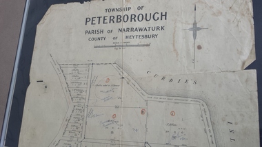
Map - Map of the township of Peterborough, Township of Peterborough
Same map as 4012 but printed names are easier to read. Hand drawn arrows show the road now built connecting Macs St to the Warrnambool RdShows early layout of the town and names of landownersgovernment map of the township of Peterborough with handwritten notes on it. Includes the names of the landowners 1931some hand drawn arrows.peterborough, old maps, maps -
Stawell Historical Society Inc
Map, Township of Stawell Photo Map, 1947
Photograph of Stawell from Air Circa 1947. Shows mining sites and townshipmining, gold, map -
Whitehorse Historical Society Inc.
Document, Virtual Vermont - Norwich Township, 2015
A draft copy of a book on the history of the failed Norwich Township proposal in Vermont 1858.A draft copy of a book on the history of the failed Norwich Township proposal in Vermont 1858.A draft copy of a book on the history of the failed Norwich Township proposal in Vermont 1858.norwich village vermont, proposed -
 Whitehorse Historical Society Inc.
Article, Blackburn A Model Township, 1880's
During the boom years of the 1880's, the new township of Blackburn was designed and built.During the boom years of the 1880's, the new township of Blackburn was designed and built.During the boom years of the 1880's, the new township of Blackburn was designed and built.blackburn, gardiner's creek, blackburn lake, freehold investment and banking company of australia ltd, goodwin, george augustus -
 Ballarat Heritage Services
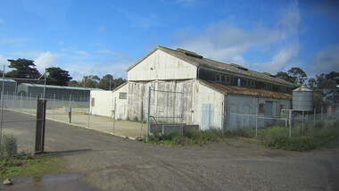
Photograph - digital images, L.J. Gervasoni, Cocoroc township - Werribee farm, 2011
Colour digital images images showing the former township of Cocoroc, Werribee farmcocoroc, town, shed, werribee farm, mmbw, melbourne metropolitan board of works, settlement, farm -
 City of Kingston
Pamphlet - Colour, J. F. Brady, Matthiesson's Estate, Highett, c. 1905
Sales plan for land in the suburb of Highett, bounded by Tennyson Street, James Street and Point Nepean Road and including Maher Street, Connors Street, Enright Street, Edward Street, James Street and Matthieson Street.The developing urban area of Highett within the City of Kingston. This land sale pamphlet illustrates the subdivision of land within the municipality and the changing demographic of the district as new houses are constructed close to infrastructure.Colour pamphlet advertising for private sale subdivisions in the Matthiesson's Estate, Highett. Incorporates a map of the estate bordered by Tennyson Street, James Street and Point Nepean Road and including Maher Street, Connors Street, Enright Street, Edward Street, James Street and Matthieson Street.Handwritten in blue pencil: x marked on every subdivision on the map Handwritten in grey pencil at the end of the Price List: x not sold Handwritten in grey pencil adjacent to subdivisions 58, 167 and 166: JP. Turner Handwritten in grey pencil adjacent to subdivision 164: [indecipherable] Markings in grey pencil around the edges of the subdivision map Handwritten in grey pencil on reverse: Matthiesson / Matthiesson Estate / Matthiesson Estateland sales, estate, highett -
 Bacchus Marsh & District Historical Society
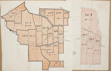
Map, Glenvale Estate and Glenmore Estate Land Sales 1909
The two land auction plans shown in this record relate to the sale of land from the Glenmore Estate property. The Glenmore property was established by C.J. (Charles James) Griffith and James Moore around 1840. Moore sold his interest to Moelesworth Greene in 1848. Greene was the nephew of the other owner Charles Griffith who died in 1863. From around the 1870s onwards parts of the Estate were subdivided and put up for sale or lease. In subsequent decades more changes in ownership occurred. These two plans document another major sale of the land from the original Glenmore Estate including part of the estate which had become used for dairy farming and was at that time known as the Glenvale Estate. Two single page maps pasted together on a single page of a bound volume of maps. One map shows 15 separate lots of land for sale. The other map which has the words 'Glenvale Estate' at the top of the map shows 4 lots of land for sale. Both parcels of land were originally part of the Glenmore Estate a pastoral holding belonging to C.J. Griffith and James Moore which the began in the Rowsley area south west of Bacchus Marsh in the 1840s. The maps are pasted into a bound volume containing 76 maps or plans in total. High resolution digital image stored on BMDHS computer network. bacchus marsh victoria maps, glenvale estate property, glenvale estate land sales, glenmore estate, glenmore station -
 Greensborough Historical Society
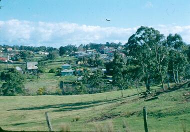
Photograph - Digital image, Frank Robinson, North end of Pope's paddock looking west to township, 1954_
North end of Pope's paddock looking west to township of Greensborough. The Blackjack property, house and acres of fruit orchards ran down to the Plenty River off Hume Street Greensborough and was the home of the Robinson family to late 1956. The photographs were taken as slides by Frank Robinson and digitised by his son James in 2015.Digital copy of colour photograph.robinson family, blackjack, popes paddock -
 Ringwood and District Historical Society
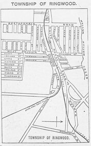
Photograph, Directory of Ringwood Township, from Sands and McDougall Directory - 1905. (New Street is incorrectly shown as Heatherdale Road on this map. Heatherdale Road's actual location is to the east, beyond the top of the map perimeter.)
Catalogue card reads, 'Directory of Ringwood Township - 1905. From Sands and McDougall Directory.' -
Ringwood and District Historical Society
Magazine, E.C.M. Graphics, The Victorian Real Estate Journal, Dec-87
The Victorian Real Estate Journal Vol 51 No.4. published December 1987 containing reports and articles.30 page booklet about real estate, coloured front page. -
 Eltham District Historical Society Inc
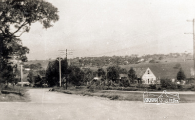
Photograph, Main Road, Lower Plenty
Black and white photograph of Main Road, Lower Plenty looking west from Old Eltham Roadlower plenty, main road, old eltham road -
 Eltham District Historical Society Inc
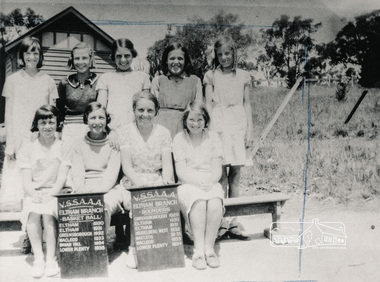
Photograph, Lower Plenty Basketball Team, c.1935, 1935c
Black and white photograph copy of an original image of Lower Plenty Girls Basketball team, c.1935basketball, netball, sports, lower plenty