Showing 298 items
matching river crossings
-
 Eltham District Historical Society Inc
Photograph, Peter Bassett-Smith, Upper Yarra Dam, Spring Tour, 22 Oct 1995, 22/10/1995
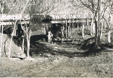
EXPLORING THE UPPER YARRA (Newsletter No. 105, November 1995, by Bettina Woodburn) We enjoyed the Spring Excursion, this year "Exploring the Upper Yarra" - in spite of the constant rain and the countryside under the cloud cover, especially in the valleys, being mainly shiny shades of green. The occasional fields of buttercups, clumps of arum lilies and splendid rhododendron and other flowering bushes became very special. The Cobb and Co coach was warm and a cosy retreat as we zig-zagged on the highways and byways to glimpse the Yarra River, upstream and down, its secret places, and particularly the many bridges. Russell excelled as 'Poet Laureate', reading from Dacre Smyth's book. This 1979 publication includes paintings of all the bridges along the river with poems and brief descriptions of each one. Some of the bridges are in out of the way places and are not very well known. We looked forward to hearing the poetry as much as seeing the ' constructions'…Big Pat (was he short or tall, lean or fat? He did win the two hundred pound reward for discovering gold and had the creek named after him), about the 'Eddies'?, and the disliked 'meccano' bridge in Warburton, etc. etc. The hot roast lunch in the old Reefton Hotel was also most welcome. It was easy to imagine it peopled by miners and early settlers. Starting by crossing the new (1974) concrete bridge at Warrandyte we headed through Wonga Park with views to the Christmas Hills and to the escarpment of the Yering Gorge, which causes flood waters to back up through the Yarra Glen plain, so avoiding disasters downstream. At the end of a long driveway we found the wooden, privately owned Henley Bridge (1935 after the 1934 floods). This facilitates access to different parts of Henley Farm and to Lilydale. Everard Park, named after Blanche Shallard's father, a State Member for 17 years, below the Highway Yarra crossing was in need of care. It is 10 miles from Yarra Glen by road but, as "Yarra Marra” canoeists well know, 32 winding miles down by water. After more delightful countryside scenes we joined the Warburton Highway at Woori Yallock. From the old Railway Station at Launching Place the Centennial Trail for walkers, cyclists and ' horse riders has replaced the rails. The line from Lilydale was opened in 1901, and the last diesel freight train ran to Warburton in 1965. It continued to rain as we had morning tea in Warburton in a shelter between footbridges. From here we continued upstream past the Bridge to O'Shannasy Lodge and Reservoir, Starvation Creek, and the Peninsular tunnel (miners dug it as at Pound Bend) which we visited (scrambling down those steps!) on our return after lunch. Our furthermost point was the Upper Yarra Dam Reserve (and vast catchment area). Finished in 1957 after ten years work and 100 years after Yan Yean, it supplies much of Melbourne's water. After crossing the 30m Launching Place Bridge to the Eltham side of the Yarra and Healesville, we saw in the distance the Yarra Glen Timber Trestle Bridge over the river flats "the longest for years in the land it was said!" Harry's dream of "better weather over the Divide" unfortunately didn't come true, but I'm sure we 36 members will retain happy memories of a day that was wet and green and filled with Bridges. Bettina Woodburn - October 1995 Record of the Society's history of activities - Spring 1995 excursionColour photographactivities, upper yarra dam, 1995, peter bassett-smith -
 Eltham District Historical Society Inc
Photograph, Peter Bassett-Smith, Upper Yarra Dam, Spring Tour, 22 Oct 1995, 22/10/1995
EXPLORING THE UPPER YARRA (Newsletter No. 105, November 1995, by Bettina Woodburn) We enjoyed the Spring Excursion, this year "Exploring the Upper Yarra" - in spite of the constant rain and the countryside under the cloud cover, especially in the valleys, being mainly shiny shades of green. The occasional fields of buttercups, clumps of arum lilies and splendid rhododendron and other flowering bushes became very special. The Cobb and Co coach was warm and a cosy retreat as we zig-zagged on the highways and byways to glimpse the Yarra River, upstream and down, its secret places, and particularly the many bridges. Russell excelled as 'Poet Laureate', reading from Dacre Smyth's book. This 1979 publication includes paintings of all the bridges along the river with poems and brief descriptions of each one. Some of the bridges are in out of the way places and are not very well known. We looked forward to hearing the poetry as much as seeing the ' constructions'…Big Pat (was he short or tall, lean or fat? He did win the two hundred pound reward for discovering gold and had the creek named after him), about the 'Eddies'?, and the disliked 'meccano' bridge in Warburton, etc. etc. The hot roast lunch in the old Reefton Hotel was also most welcome. It was easy to imagine it peopled by miners and early settlers. Starting by crossing the new (1974) concrete bridge at Warrandyte we headed through Wonga Park with views to the Christmas Hills and to the escarpment of the Yering Gorge, which causes flood waters to back up through the Yarra Glen plain, so avoiding disasters downstream. At the end of a long driveway we found the wooden, privately owned Henley Bridge (1935 after the 1934 floods). This facilitates access to different parts of Henley Farm and to Lilydale. Everard Park, named after Blanche Shallard's father, a State Member for 17 years, below the Highway Yarra crossing was in need of care. It is 10 miles from Yarra Glen by road but, as "Yarra Marra” canoeists well know, 32 winding miles down by water. After more delightful countryside scenes we joined the Warburton Highway at Woori Yallock. From the old Railway Station at Launching Place the Centennial Trail for walkers, cyclists and ' horse riders has replaced the rails. The line from Lilydale was opened in 1901, and the last diesel freight train ran to Warburton in 1965. It continued to rain as we had morning tea in Warburton in a shelter between footbridges. From here we continued upstream past the Bridge to O'Shannasy Lodge and Reservoir, Starvation Creek, and the Peninsular tunnel (miners dug it as at Pound Bend) which we visited (scrambling down those steps!) on our return after lunch. Our furthermost point was the Upper Yarra Dam Reserve (and vast catchment area). Finished in 1957 after ten years work and 100 years after Yan Yean, it supplies much of Melbourne's water. After crossing the 30m Launching Place Bridge to the Eltham side of the Yarra and Healesville, we saw in the distance the Yarra Glen Timber Trestle Bridge over the river flats "the longest for years in the land it was said!" Harry's dream of "better weather over the Divide" unfortunately didn't come true, but I'm sure we 36 members will retain happy memories of a day that was wet and green and filled with Bridges. Bettina Woodburn - October 1995 Record of the Society's history of activities - Spring 1995 excursionColour photographactivities, upper yarra dam, 1995 -
 Glen Eira Historical Society
Article - MCKINNON
Brief typed history of McKinnon settlement taken from Moorabbin A Pictorial History 1862-1994 by John Cribben. Includes photocopied pages of railway gates, five land estate flyers and an article from the McKinnon Progress, undated.mckinnon, cribben john, crop production, markets, farmers, elster creek, mcmillan archibald, thomas street, centre road, wheatley road, vineyards, south road, ormond, brighton, moorabbin, irish, immigrants, bentleigh, priests, hanrahan pierce, hanrahan johanna, caroll michael, caroll catherine, howes eliza, howes john, howes edward, shanahan denis, shanahan ellen, gould james, gould catherine, howes george, bignell road, jasper road, tucker road, mcguiness family, quinn family, halinan family, malane family, inns, the gardeners arms, mckinnon hotel, bent james, bent thomas, tickets of leave, murray road, were nicholas, sargood family, ripponlea, mansions, elsternwick, st. stephens’ common school, church of england, school houses, evelyn street, st. john’s anglican church, telegraph offices, post offices, state schools, manchester road, north road, nicholls buildings, rivers frank, rivers ray, shops, pridgeon mr., elm grove, sobrin mr., clark misses, greaves bakery, armitage mrs., rout mr., tunnicliffe mrs., lance’s milk bar, johnson’s hardware shop, stiringer mrs., white horrie, robinson’s, mcinnerney’s flower shop, jean darling’s cakes, wyles jim, mckinnon progress association, glen orme avenue, ormond theatre, theatres, lester harry, the plaza, railway crossing, railway gates, wright street, nichols l., builders, pine grove, halls, st. elmo estate, patterson station estate, patterson road, brewer road, purton road, clee hill estate, railway park, hawthorn grove, wattle grove, elm grove, learys estate, manchester road, selkirk avenue, masters estate, lancaster street, moylan street, moorabbin railway crossing -
 Federation University Historical Collection
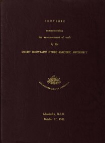
book, Truth & Sportsman Ltd, Souvenir commemorating the commencement of work by the Snowy mountains hydro-electric authority, 17/10/1949
... Relief Plan, Horseman crossing the Eucumbene River, Mildura... Relief Plan, Horseman crossing the Eucumbene River, Mildura ...It is assumed that a member of the Ballarat School of Mines attended the commencement of work at the Snowy Mountains hydro-electric centre.Burgundy cover with gold printing. Black print, photos and diagrams on white paper (31 pages). Bound by 3 staples. The contents include the story of the Snowy. Images include W.J. McKell, J.B. (Ben) Chifley, J. McGirr, Nelson Lemmon, Hume Weir, Jindabyne valley (now flooded), Jindabyne township (now flooded), illustration of water Power, survey team at Adaminaby, Snowy Mountains Relief Plan, Horseman crossing the Eucumbene River, Mildura, Burrinjuck Dam under construction, transmission lines, W. Hudson.snowy mountains hydro-electricty scheme, snowy mountains hydro-electric authority -
 Federation University Historical Collection
Postcards - black and white, Butt Bourton, Burford
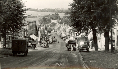
... town or hilltown and ford, the crossing of a river. (Wikipedia)... and ford, the crossing of a river. (Wikipedia) chatham family ...Burford is a small town on the River Windrush in the Cotswold hills in west Oxfordshire, England, about 18 miles (29 km) west of Oxford, 22 miles (35 km) southeast of Cheltenham and only about 2 miles (3 km) from the Gloucestershire boundary. The toponym derives from the Old English words burh meaning fortified town or hilltown and ford, the crossing of a river. (Wikipedia)A streetscape photographic view of Burford, England showing buildings, cars and people. chatham family archive, burford -
 Federation University Historical Collection
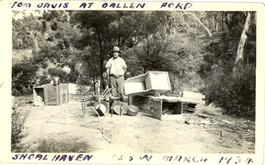
Photograph - Photograph - black and white, Oallen Ford and Shoalhaven River, 1934, 1934
Two black and white photographs associated with Donald Mather. .1) A man, Tom Davis stands surrounded with gold mining equipment such as gold pans, cradles, picks and buckets. He is at Oallen Ford on the Shoalhaven River, New South Wales .2) A man stands beside a ute with 2 women standing on the tray. The photo was taken after crossing a ford at Shoalhaven, New South Walesdonald mather, mather, shoalhaven river, mining, ute, utility, car, gold mining -
 Federation University Historical Collection
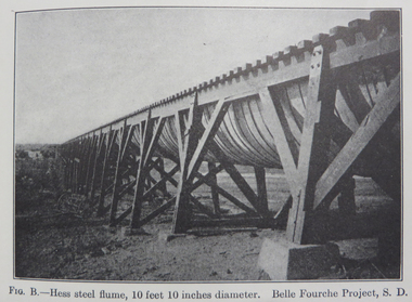
Book, Irrigation Practice and Engineering Volume 2: Conveyance of Water and Volume 3: Irrigation Structures and Distribution System by B.A. Etchevery, 1915 and 1916
Blue hard covered books. .2) Volume III Irrrigation Structures and Distrubution Systemirrigation, water canals, tunnels, flumes, pipes, concrete pipes, wrought iron and steel pipes, wooden pipes, california, diversion works, weirs, spillways, canals, check gates, railroad crossing, america, united states of america, university of california, yellowstone river, colorado, arizona, windlass hoist, twin falls, idaho, arkansas valley, truckee-carson, salmon river, umatilla, cippoletti weir box -
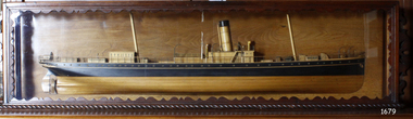 Flagstaff Hill Maritime Museum and Village
Craft - Ship Model, S.S. Nelson, 1877 - 1984
This beautifully made ship model is a side relief of the steam ship “S.S. Nelson”, which was launched in 1877. The model’s case stands out because of its ornately carved internal frame. Relief models of ships, sometimes called half models, were often built by the shipbuilders as an exact scale model of the finished ship. The shipbuilders would use the model to ensure that the design was balanced. They would use the model as a point of reference during building. Also, ship models were used to demonstrate the designs to prospective buyers. It is not known whether this model of the “S.S. Nelson” was made for these purposes. HISTORY of the “S.S. Nelson” During the period 1840-1890 shipping was the cheapest and most practical means of carrying produce and goods to and from coastal towns such as Warrnambool. In the 1850s regular domestic steamer services began and by 1870 the passenger trade was booming. Passengers were taken to the ship’s side in small boats called lighters, which took it to ships at anchorage in Lady Bay, then climbed aboard up ladders or gangways. Their fare covered accommodation Saloon/Cabin section (higher class and more expensive) or the Steerage section (lower class and less expensive, below deck level). Produce included livestock such as pigs and fowls, and dairy products, bales of wool, and potatoes. The goods were loaded from the Warrnambool Jetty into the lighters. The S.S. Nelson was built by Messrs Blackwood and Gordon of Port Glasgow for a cost £25,000 in 1877. She was an iron screw steamer with an overall length of 200 feet, beam 25.5 feet and a depth of hold of 19.4 feet, which gave her a gross measurement of 649 tons. Her engines gave her a best speed of 13 knots and a maintainable speed of 12 knots. She was described as a handsome, star decked, efficient steamship, fitted with accommodating for 75 first class passengers in a saloon, and 40 second class passengers in a cabin. The S.S. Nelson arrived in the colony of Victoria on March 9th, 1877. She was first registered in Warrnambool by the Warrnambool Steam Packet Company under the management of Mr William Evans, and employed in the coastal trade of south west Victoria. She was very popular in 1878, registered under the new ownership of the Western Steamship Navigation Company, trading between Melbourne, Warrnambool and Portland. Captained John Nicholson commanded the S.S. Nelson after the previous captain, Thomas Smith, was suspended in 1882 for six months by the Victorian Steam Navigation Board following the collision between the S.S. Nelson and the S.S. Julia Percy. Other Captains include S Drewet and John Thompson. The S.S. Nelson was sold to Messrs. Huddart, Parker and Co. and re-registered in Melbourne on June 23rd, 1890. The new owners intended to use her for their Bass Strait crossing between Melbourne, Victoria and Launceston, Tasmania. On the night of Friday, June 27th 1890, under the command of Captain Carrington, she was on her way to Launceston on her first crossing for her new owners. She had no passengers and very little cargo and was to return to Melbourne with passengers the following morning. She was only 21 hours out of the dock when she struck Porpoise Rock in the Tamar River. All crew of 25 were saved but the bulkheads gave way and she rapidly filled before keeling over and disappearing in approximately 130 feet of water. The new owners had fully insured the almost 14-year-old S.S. Nelson with the Australian Alliance Insurance Company and she had only been in their possession for four days. This ship model of the S.S. Nelson is significant for its connection with the steam screw ship S.S. Nelson, one of a fleet of vessels owned by the Warrnambool Steam Packet Company. The S.S. Nelson was specifically built and purchased for the Victorian coastal trade business of the late 19th century, when shipping was the cheapest and most practical means of transporting goods and passengers between Victoria’s coastal towns and the major port at Melbourne. Once the railway came to Warrnambool in 1889, the steam shipping industry began to decline.Ship model; relief of the S.S. Nelson, showing deck superstructure, ventilators and single funnel. Ship's name is painted on the bow "NELSON". Wood model, varnished finish over natural wood and black painted areas. Timber case with ornate edging and glass front and sides."NELSON" painted on bowflagstaff hill, warrnambool, shipwrecked-coast, flagstaff-hill, flagstaff-hill-maritime-museum, maritime-museum, shipwreck-coast, flagstaff-hill-maritime-village, s.s. nelson steam ship 1877, screw steamer, 1877 vessel, ship model s.s. nelson, blackwood and gordon port glasgow, warrnambool steam packet company, western steam navigation company, south west coast trader, sea transport melbourne to portland, victorian steam navigation board, s.s. julia percey, captain john nicholson, captain thomas smith, captain s drewet, captain john thompson, captain carrington, huddart, parker and co, bass strait crossing 1890, sea transport melbourne to launceston, porpoise rock tamar river, australian alliance insurance company, ship model making, vessels, victorian coastal trader -
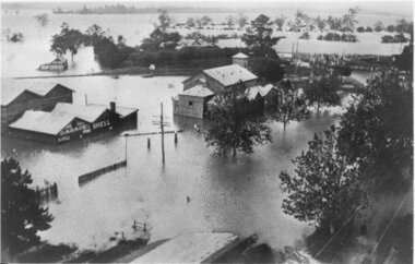 Yarra Glen & District Historical Society
Black and white photographs, Flood waters in Yarra Glen December 1934
... flood railway crossing river view guest house shell garage peg ...Black and white photograph of Bell street, Yarra Glen, taken in December 1934 from the tower of the Grand Hotel, looking south towards the railway crossing, during the floods. The Victoria Hall is the building in the centre of the photograph. Directly behind the Victoria Hall, the roof of 'River View' guest house can be seen. The Shell Garage, operated by Les Orenshaw, on the left of the photograph was originally built and occupied as a peg factory.The view extends from Bell street across the river flats with the high ground of Chateau Yering in the background. Bell Street is defined by the street trees where the water covers the road in the foreground grand hotel, victoria hall, bell street, floods 1934, 1934 flood, railway crossing, river view, guest house, shell garage, peg factory, river flats, chateau yering, les orenshaw, street trees -
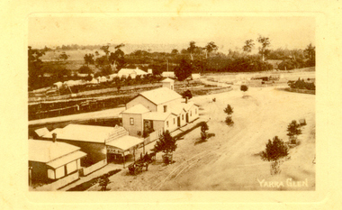 Yarra Glen & District Historical Society
Sepia postcards, Yarra Glen
... street tree guards railway crossing river view street trees bell ...Sepia postcard with a view taken from the Grand Hotel tower looking down on Bell Street and the railway crossing at Yarra Glen very late 19th century. Young street trees on Bell Street. On east side of Bell Street are a dwelling, a general store, the Victoria Hall, a horse trough. Beyond the railway line is 'River View', the bridge over the river and the Yering flats.On back of postcard at the top "POST CARD". On the left hand side "THIS SPACE MAY BE USED FOR PRINTED OR WRITTEN MATTER”. On the right hand side "ONLY THE ADDRESS TO BE WRITTEN HERE”. In a box in the right hand corner "A HALF-PENNY STAMP TO BE PLACED HERE". Along the left hand margin "Ajax series. Printed in England". In blue biro is written "G. Keets Yarra Glen". Copy 2 has the following handwritten in black ink: "Yarra Glen. 28.8.11. Dear Maggie Hope you will like the Postcard. I also hope your head is better. On Saturday we took the kitten down to Dawborn's shop to catch some mice. When we got down there the kitten got away from us and we never got it till Monday morning. This is all the news this time. From your loving cousin, Walter.yarra glen, railway line, grand hotel, victoria hall, bell street, tree guards, railway crossing, river view, street trees, bell st, general store, horse trough -
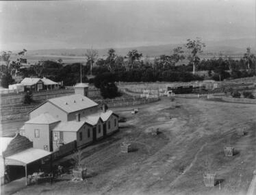 Yarra Glen & District Historical Society
Black and white photographs, Yarra Glen railway crossing c.1900
... -ranges yarra glen victoria hall railway crossing river view ...Black and white photograph in light brown card slip case. The slip case has an image on the front cover of a head and shoulder bust. The photograph was taken about 1900 from the tower of the Grand Hotel looking down upon the Victoria Hall and the railway crossing. In the lower left corner is W.J.Dawborn's General Store. In front of the store is a horse and spring dray and another horse hitched to a veranda post. Next to the store is the Victoria Hall and beyond that a water trough. The railway crossing is in the centre of the picture with two railway cattle trucks next to the cattle yards. Beyond the railway on the left hand side is the property later known as 'River View'. Beyond the river lined with trees are the Yering flats across which can be seen the long trestle railway bridge. In the foreground of the picture is Bell Street lined with trees in wooden tree guards.yarra glen, victoria hall, railway crossing, river view, general store, w j dawborn, horse and cart, horse and dray, spring dray, horse hitched, hitching post, water trough, railway truck, cattle truck, cattle yards, stock yards, yering flats, trestle railway bridge, trestle bridge -
 Federation University Historical Collection
Book, The Old Pioneers' Memorial History of Melbourne From the Discovery of Port Phillip to the World War, 1924
... opening Map of Melbourne and Collingwood Prince's Bridge Crossing ...Blue hard covered book of 494 pages. Images, and a large plan of prominent burials in the Melbourne Old Cemetery, and a Map of Melbourne. melbourne, melbourne cemetery, melbourne old cemetery, john batman, edmund hobson, batman's map, st francis' church, james balfour, mrs hornbrook, paddy's market, wilson hall, working men's college, henry kendall, le souef's cottage, world war one, westernport, melbourne cup, hoddle, collingwood, south melbourne, prahran, richmond, kew, brunswick, coburg, preston, hawthorn, camberwell, nunawading, doncaster, st kilda, brighton, sandringham, cheltenham, caulfield, oalkleigh, footscray, sunshine, north melbourne, carlton, ballarat school of art library, ballarat technical art school, book plate, library plate, hume and hovell's overland journey 1824-5, major mtichell's overland journey, australia felix, booplate, aborigine, aboriginal, captain cook, arthur phillip, isaac smith, george bass, matthew flinders, john murray, catain baudain, captain collins, edward henty, portalnd, map od melbourne in 1938, john pascoe fawkner, the "enterprise: and fawkner's first home, old colonists' homes, rushall crescent north fitszroy, richard bourke, the old melbourne post offfice, old governmnt house, toorak, latrobe's house at jolimont, first melbourne land sale, melbourne water supply, peter henry smith, victorian legislative council opening, map of melbourne and collingwood, prince's bridge, crossing the rivers by punt, f.a> rucker, canvas city emerald hill, arrival of the gold escort in melbourne, the yarra, queen's wharf, tall ships, old st james, mary e. budd, st francis church, michael carr, meolbourne city mission, state library of victoria, melbourne public library, bourke street, angus mcmilan, methodist ladies college, ormond college, armistance celebrations, robert russell, mia mia, theatre royal bouke st, melbourne from flaggstaff hill, federal coffee palace collins st, lord melbourne, melbourne mint, old melbourne town hall, robert russell's melbourne and yarra falls, mandevalle hall, point lansdale lighthouse, wilson's promontory, margaret m. ward cole, williamstown, flinders st melbourne, queenscliff battery, broadmeadows soldiers' camp, embarkation of first troops on the 'ceramic', general monsash, ian hamilton, general bridges, victorian war memorial, national war memorial, st kilda pier, first melbourne cup, hoddle's grid, albert park, melbourne mechanic's institute, st kilda toll gate, munted policeman, springthorpe memorial, james bonwick, mornane's paddock, victorian railways melbourne and surburban lines, carlton gardens, thomas napier, wiliam westgarth, george augustus robinson, william lonsdale, elizabeth mary batman, peomena frances darling batman, dig tree, exhibition of 1854, exhibition of 1866, exhibition buildings, geelong harbour, jubilee lake, port campbell, warrnambool, queenscliff lightboat, batman's first house -
 Bendigo Historical Society Inc.
Newspaper - JENNY FOLEY COLLECTION: CAIRN UNVEILING
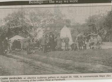
... crossing of the Loddon River at Fernihurst. The clip... (Sir) Thomas Mitchell's crossing of the Loddon River ...Bendigo Advertiser ''The way we were'' from Monday, March 12, 2001. Cairn unveiling: an attentive audience gathers on August 29, 1936, to commemorate Major (Sir) Thomas Mitchell's crossing of the Loddon River at Fernihurst. The clip is in a folder.newspaper, bendigo advertiser, the way we were -
 Bendigo Historical Society Inc.
Newspaper - JENNY FOLEY COLLECTION: ETCHED IN HISTORY
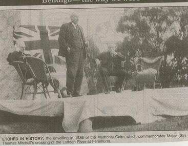
... commemorates Major (Sir) Thomas Mitchell's crossing of the Loddon River...) Thomas Mitchell's crossing of the Loddon River at Fernihurst ...Bendigo Advertiser ''The way we were'' from 2001. Etched in history: the unveiling in 1936 of the Memorial Cairn which commemorates Major (Sir) Thomas Mitchell's crossing of the Loddon River at Fernihurst. The clip is in a folder.newspaper, bendigo advertiser, the way we were -
 Bendigo Historical Society Inc.
Photograph - HARRIS COLLECTION: STEREOSCOPIC VIEWS, Nineteenth Centur
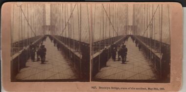
Stereoscopic views. Kilburn Brothers Littleton , N H. 1. Trinity college Dublin. 2. Brooklyn Bridge, scene of the accident , May 30th 1883. 3. Spinning Room , Mechanics Mill, Fall River Mass. 4. Bay Grove Hill, Greenwood Cemetery, Brooklyn, N Y. 5.Crossing the Great Suspension Bridge, by rail. 6. Dining Hall , Grand Union Hotel, Saratoga, Largest Dining Hall in the World. 7. Phantom Leaves. 8. Full Moon. 9. Merced River, Yo-Semite , Cal. 10. I Breathe Inspiration. 11. United States Hotel Park, Saratoga.Kilburn Brothers Littleton N H.photography, viewers -
National Vietnam Veterans Museum (NVVM)
Booklet, Field engineering and mine warfare: pamphlet no. 8: demolitions, Assault river crossing, part 2, 1961, 1953
... : demolitions, Assault river crossing, part 2, 1961...: demolitions, Assault river crossing, part 2, 1961 Booklet Booklet ...british armed forces - service manuals -
Port Melbourne Historical & Preservation Society
Document - Short Road Ferry ticket, c.1974
... A single trip 15 cent ticket for crossing the Yarra River... Vehicles A single trip 15 cent ticket for crossing the Yarra River ...From the collection of Warren DOUBLEDAY. The short Road ferry ran between the end of Williamstown Road in Port Melbourne across the narrowest section of the Yarra River to the bottom of the Strand in Williamstown. The name came from it being the 'short road' between the two places. There was a type of ferry service in operation from around 1873 which was modernised in the 20th century to take cars and trucks across the river. It was operated by two heavy chains which sank to the river bed to allow ships to pass.A single trip 15 cent ticket for crossing the Yarra River from Williamstown on the Short Road Ferry. The off white ticket has two diagonal blue stripes and the number F 048261 printed on the side. transport - ferries, short road ferry, williamstown, transport - motor vehicles -
Port Melbourne Historical & Preservation Society
Document - Short Road Ferry ticket, c.1974
... A single trip 15 cent ticket for crossing the Yarra River... Vehicles A single trip 15 cent ticket for crossing the Yarra River ...From the collection of Warren DOUBLEDAY. The Short Road ferry ran between the end of Williamstown Road in Port Melbourne across the narrowest section of the Yarra River to the bottom of the Strand in Williamstown. The name came from it being the 'short road' between the two places. There was a type of ferry service in operation from around 1873 which was modernised in the 20th century to take cars and trucks across the river. It was operated by two heavy chains which sank to the river bed to allow ships to pass.A single trip 15 cent ticket for crossing the Yarra River from Williamstown on the Short Road Ferry. The off white ticket has two diagonal blue stripes and the number P016322 printed on the side. transport - ferries, short road ferry, williamstown, transport - motor vehicles -
Port Melbourne Historical & Preservation Society
Document - Short Road Ferry ticket 1974, 7 Jan1974
... A single trip 20 cent ticket for crossing the Yarra River... the narrowest section of the Yarra River to the bottom of the Strand ...From the collection of Warren DOUBLEDAY. The Short Road ferry ran between the end of Williamstown Road in Port Melbourne across the narrowest section of the Yarra River to the bottom of the Strand in Williamstown. The name came from it being the 'short road' between the two places. There was a type of ferry service in operation from around 1873 which was modernised in the 20th century to take cars and trucks across the river. It was operated by two heavy chains which sank to the river bed to allow ships to pass.A single trip 20 cent ticket for crossing the Yarra River from Williamstown on the Short Road Ferry. The off white ticket has two diagonal blue stripes and the number C049655 printed on the side. On reverse side of ticket -" 8.25 pm trip. 7-1-74 (last East bound for day'"transport - ferries, short road ferry, williamstown, transport - motor vehicles -
Port Melbourne Historical & Preservation Society
Photograph - Williamstown 'Short Road' ferry (punt) crossing the Yarra River, 1950s
... Williamstown 'Short Road' ferry (punt) crossing the Yarra...' ferry (punt) crossing the Yarra River from Newport to Port...' ferry (punt) crossing the Yarra River from Newport to Port ...copied from a photograph held by the City of Port PhillipLaser copy of photograph of the Williamstown 'Short Road' ferry (punt) crossing the Yarra River from Newport to Port Melbourne's Williamstown Road.transport - ferries -
 Monbulk RSL Sub Branch
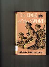
Book, Readers Book Club, The edge of the sword, 1954
In April 1951, at the height of the Korean War, Chinese troops advanced south of the 38th parallel towards a strategic crossing-point of the Imjin River on the invasion route to the South Korean capital of Seoul. The stand of the 1st Battalion, the Gloucestershire Regiment, against the overwhelming numbers of invading troops has since passed into British military history. In The Edge of the Sword General Sir Anthony Farrar-Hockley, then Adjutant of the Glosters, has painted a vivid and accurate picture of the battle as seen by the officers and soldiers caught up in the middle of it. The book does not, however, end there. Like the majority of those who survived, the author became a prisoner-of-war, and the book continues with a remarkable account of his experiences in and out of Chinese prison camps. This book is not an attempt at a personal hero-story, and it is certainly not a piece of political propaganda. It is, above all, an amazing story of human fortitude and high adventure.Ill, p.286non-fictionIn April 1951, at the height of the Korean War, Chinese troops advanced south of the 38th parallel towards a strategic crossing-point of the Imjin River on the invasion route to the South Korean capital of Seoul. The stand of the 1st Battalion, the Gloucestershire Regiment, against the overwhelming numbers of invading troops has since passed into British military history. In The Edge of the Sword General Sir Anthony Farrar-Hockley, then Adjutant of the Glosters, has painted a vivid and accurate picture of the battle as seen by the officers and soldiers caught up in the middle of it. The book does not, however, end there. Like the majority of those who survived, the author became a prisoner-of-war, and the book continues with a remarkable account of his experiences in and out of Chinese prison camps. This book is not an attempt at a personal hero-story, and it is certainly not a piece of political propaganda. It is, above all, an amazing story of human fortitude and high adventure. korean war 1950-1953 - history, korean war - campaigns - gloucestershire regiment -
 Bendigo Historical Society Inc.
Photograph - 'MARYDALE' AXEDALE COLLECTION: PHOTOGRAPH DRY CREEK BED
Photograph.View of dry river bed, probably Campaspe River, Axedale, with open land with bridge crossing, at ''Marydale'', Axedale.axedale, history, marydale property -
 Monbulk RSL Sub Branch
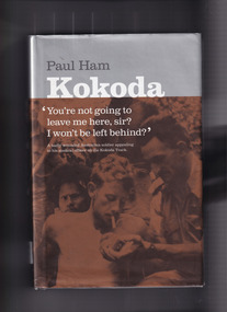
Book, Paul Ham, Kokoda, 2004
... , fought back and forth along 90 miles (145 km) of river crossings ...For the first time ever, the compelling story of the infamous Kokoda Track campaign has been told from both sides of the conflict. In a unique and balanced portrayal, renowned journalist Paul Ham recounts both the Australian and Japanese perspectives of the events on the hellish Papuan jungle trail where thousands fought and died during World War II. Based on extensive research in Australia and Japan, and including previously unpublished documents, Kokoda intimately relates the stories of ordinary soldiers in 'the world's worst killing field', and examines the role of commanders in sending ill-equipped, unqualified Australian troops into battles that resulted in near 100 per cent casualty rates. It was a war without mercy, fought back and forth along 90 miles (145 km) of river crossings, steep inclines and precipitous descents, with both sides wracked by hunger and disease, and terrified of falling into enemy hands. Defeat was unthinkable: the Australian soldier was fighting for his homeland against an unyielding aggressor; the Japanese ordered to fight to the death in a bid to conquer 'Greater East AsiaIndex, bib, ill, p.602.non-fictionFor the first time ever, the compelling story of the infamous Kokoda Track campaign has been told from both sides of the conflict. In a unique and balanced portrayal, renowned journalist Paul Ham recounts both the Australian and Japanese perspectives of the events on the hellish Papuan jungle trail where thousands fought and died during World War II. Based on extensive research in Australia and Japan, and including previously unpublished documents, Kokoda intimately relates the stories of ordinary soldiers in 'the world's worst killing field', and examines the role of commanders in sending ill-equipped, unqualified Australian troops into battles that resulted in near 100 per cent casualty rates. It was a war without mercy, fought back and forth along 90 miles (145 km) of river crossings, steep inclines and precipitous descents, with both sides wracked by hunger and disease, and terrified of falling into enemy hands. Defeat was unthinkable: the Australian soldier was fighting for his homeland against an unyielding aggressor; the Japanese ordered to fight to the death in a bid to conquer 'Greater East Asiaworld war 1939 – 1945 – campaigns – kokoda, world war 1939-1945 - campaigns - south west pacific -
 Stratford and District Historical Society
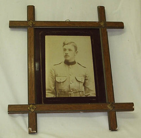
Photograph, Framed
The photograph that appears in this frame is a copy. The original is catalogued at 01314. Sgt David Hamilton Pruden, 404, enlisted from Newry and was killed at Koster River in the Trasnvaal on 21 July 1900, and was buried at Rustenburg cemetery. He is commemorated in a large tablet in the Stratford Mechanics' Institute. This photograph originally hung in the Stratford Mechanics' Institute. A framed sepia copy photographic print of a head and shoulders portrait of a young man in dress uniform of the Victorian Mounted Rifles, labelled Pte D.Pruden and presumed to be David Hamilton Pruden, who died in Africa during the Boer War. The frame, of crossed wooden bars with decorative metal at each crossing, appears to be commercially produced. Backing support for the frame is a section of an 1893 calender for an unknown insurance firm, agent J.B Kelly at Stratford, which has been detached for separate cataloguing.boer war 1899-1902 -
Tatura Irrigation & Wartime Camps Museum
Photograph, Cattanach Canal, 1957
Taken by the photographer for Victoria State Rivers and Water Supply Commission.Large sepia photograph - Construction equipment middle foreground, two bridges, truck crossing second bridge, trees, flat paddock, scattered trees, man working on nearer concrete bridge support.Below photo: "Cattanach Canal / Rail and Highway Bridges near Murchison"irrigation, victoria state rivers and water supply commission, cattanach canal, bridges -
 City of Ballarat
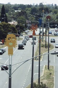
Artwork, other - Public Artwork, Ratartat, Crossing Rubicon, 2008
“This public art project honours the people and suburb of Sebastopol, as well as providing a strong visual identity for Albert Street. It will make the street a lot more attractive and welcoming. The project is the outcome of extensive consultation with groups and individuals in the Sebastopol community, who have made suggestions both as to the nature of the project but also the aspects of life in their community they wanted to represent through the artwork.”Crossing Rubicon by Ratartat is located in Albert Street, Sebastopol, Ballarat. A row of 16 lampposts in Sebastopol’s main street are topped with large enamelled steel sculptures of trees, representing different aspects of Sebastopol’s community life and history. Ratartat is an artistic collaboration of Ballarat-based artists Geoff Bonney and Pete Widmer. The name, Crossing Rubicon, refers to Rubicon Street, the boundary between Redan and Sebastopol. The street was named after the Rubicon River, an ancient boundary between Italy and Gaul. Julius Caesar’s decision to cross the river, thereby rebelling against the Roman Senate, gave rise to the expression “crossing the Rubicon”, meaning going past the point of no return.Sixteen powder-coated steel sculptures mounted on light polesrubicon, sebastopol, ratartat -
 Hume City Civic Collection
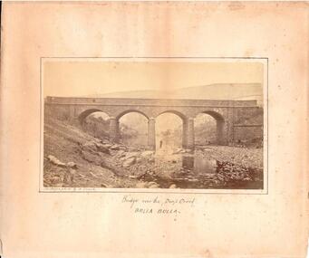
Photograph, c. 1870s - 1880s
The phtograph was taken by Alfred Sinel who was the local photgrapher in Sunbury. The four arched bridge spans the river at Deep Creek, Bulla. The bridge replaced the forde crossing which is in the foreground of the photograph. Alfred Sinel is listed in the 1874 rate book as a photographer - artist.A mounted sepia photograph of the four-arched bluestone bridge over Deep Creek at Bulla. A man is standing under the 3rd arch from the LHS. The cream mount has a ruled ink frame around the photo. The caption has been hand-written under the photograph.BRIDGE OVER THE DEEP CREEK / BULLA BULLAdeep creek, bridges, bulla, sunbury, sinel, alfred, photographers, george evans collection