Showing 4072 items
matching road plans
-
 Kiewa Valley Historical Society
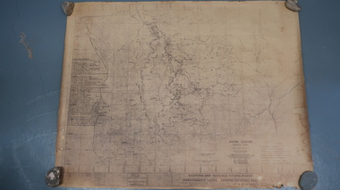
Map - Kiewa Scheme General Plan
Existing and possible future roads are numbered and named 1 - 45. The plan is based on an aerial photos taken March 1945. It includes revisions up to 1951. Signed by H.H.C. Williams, construction engineer. Mountains, rivers, roads and SECV places are named, also SECV infrastructure and construction eg. workers camps, Power stations.Significant for the information re the Kiewa Hydro Electric Scheme's development.Yellowed paper with brown print. Kiewa Scheme general plan showing its development. A lot of information is recorded. Note: Dyeline print was used which causes fading when exposed to light. Handwritten: 'Bob Duncan'bob duncan, kiewa hydro electric scheme, secv, khes development -
 Kiewa Valley Historical Society
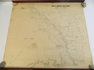
Map - Kiewa Valley, Parish Map of Mullindolingong, 12/10/1906
The map shows the names of people living in the parish of Mullindolingong in 1906. These people had leases or licences giving the reader an insight into the number of people in the area and an understanding of the size of their holdings. Infrastructure is also given including shops, schools, churches etc. Presumably it was used by the Ryder family.This map gives an historical insight into the parish of Mullindolingong as it names people and the infrastructure - roads, buildings etc. as it was in 1906. This enables the reader to compare the area at the time with other times and other places and to have an understanding of the early settlers in the area.This is a very old paper or parchment map with wooden rods top and bottom. The top rod has ribbons attached to enable hanging. The map shows the current leases and licences and when they were held by during this period, circa 1906.Mullindolingong County of Bogong. This plan has been prepared by The Most Reliable Data in the Possession of the Department up to the date of its Compilation. Information respecting Leases or Licences which await Final Completion is not recorded.parish of mullindolingong map; ryder family; early settlers; -
 Warrnambool and District Historical Society Inc.
Document, Ticket Warrnambool Botanic Gardens Night in the Gardens, 2016
This card is an invitation to attend a Night in the Gardens in March 2016 to celebrate the 150th Anniversary of the Warrnambool Botanic Gardens. The first site of the Warrnambool Botanic Gardens was near the mouth of the Hopkins River but this site proved unsuitable and a new location ( the present location) was found in 1866 bounded by Cockman Street and Botanic Road. In 1877 William Guilfoyle was commissioned to provide a new plan for the Gardens. An important curator was Charles Scoborio ( 1872 to 1906 ) This card is of minor interest as a memento of the celebrations in 2016 to celebrate the 150th anniversary of the Warrnambool Botanic Gardens A black rectangular card with white text.Night in The Gardens warrnambool botanic gardens, charles scoborio -
 Warrnambool and District Historical Society Inc.
Document, Sticker Warrnambool Botanic Gardens 150 years A Growing Legacy, 2016
This sticker was issued to celebrate the 150th anniversary of the Warrnambool Botanic Gardens. These Gardens were first established in the early 1850s on a site near the mouth of the Hopkins River but this site proved unsuitable and the Gardens were moved to the present location (Cockman Street/ Botanic Road) in 1866. In 1877 William Guilfoyle was commissioned to provide a plan for the Botanic Gardens . A prominent curator was Charles Scoborio 1872 to 1906. This sticker is a minor interest as a memento of the 150th anniversary in 2016 of the Warrnambool Botanic Gardens A white sheet of paper containing a circular shaped sticker with blue print and a logo in green and purple. The printing is in black and purple.Warrnambool Botanic Gardens 150 years A GROWING LEGACYwarrnambool botanic gardens, william guilfoyle -
 Warrnambool and District Historical Society Inc.
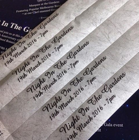
Document, Wristband Night in the Gardens, 2016
This wrist band was issued to those attending a Night in the Gardens, an event held in 2016 to celebrate the 150th Anniversary of the Warrnambool Botanic Gardens. These Gardens were first established near the mouth of the Hopkins River in the 1850s but this site proved unsuitable and they were moved to the present location ( Cockman Street/ Botanic Road) in 1866. In 1877 William Guilfoyle was commissioned to provide a plan of the Gardens. Charles Scoborio 1872 to 1906 was a prominent curator. A piece of paper with black printing and removable ends with adhesive on the back to form a temporary wrist band. Night in the Gardens 19th march 2016- 7 pm.william guilfoyle, charles scoborio -
 Warrnambool and District Historical Society Inc.
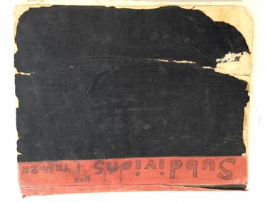
Book, Subdivision No 1 to 1420, 1930s
This is an exercise book listing subdivisions in Warrnambool from 1935 to 1977. There are 1420 entries. It gives details of the subdivisions – plan number, street, section number, allotment number, date, owner, solicitor and Titles Office number. The book is completely filled and today this information would be held in the Warrnambool City Council offices per electronic data storage. Warrnambool, founded in 1847, became a Municipality in 1856, a Borough in 1863, a Town in 1883 and a City in 1918. Subdivisions of land in the city continue to be made regularly for housing and business purposes.This book is of great historic interest because it details the subdivisions in the City of Warrnambool from 1935 to 1977. It shows the continuing growth of the city, particularly after World War Two. It will be a very useful resource for researchers. This is an exercise book with a black cardboard cover and red binding. It contains a list of City of Warrnambool subdivisions from 1935 to 1977. The cover and some of the pages are torn and ragged and the binding has come apart and has been glued together in places. The pages are ruled with blue and red lines. The pages contain handwritten material in black and blue ink. Front Cover: ‘Subdivions(sic), Nos 1 to 1420’ Inside Front Cover: ‘City of Warrnambool Subdivisions’ warrnambool city council, warrnambool subdivisions -
 Warrnambool and District Historical Society Inc.
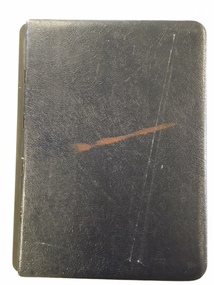
Book, Road register loose binder, 1953
This is an Alphabetical Register of the streets in Warrnambool as listed by Warrnambool City Council officers. It appears to have been a working register used in the 1950s, 60s and 70s and information has been added to the entries as it became available and as Council works were carried out in these streets. It contains information on the locality, wards, allotment numbers, lodged plan numbers, footpaths and printed information from the Victorian Local Government Departments. It sometimes gives the origin of the name of the street and some other miscellaneous information is included. It is presumed that the information contained therein has now been stored electronically. This is a most important ledger as it contains much valuable historical information on Warrnambool streets. It will be of great use to researchers. This is a loose leaf binder with a black leather cover and a black metal and cord binding mechanism. The pages are unnumbered but there is provision for insertion or removal of pages and there are leather alphabetical tabs protruding from the pages. The pages have blue ruled lines with blue lined margins and headings. The streets in Warrnambool are listed alphabetically and the information in the register contains both typed and handwritten material. There are also printed notices from the Victorian Local Government department, extracts from newspapers, copies of letters and plans of street subdivisions. There is one loose page.warrnambool city council, warrnmbool streets register -
 Warrnambool and District Historical Society Inc.
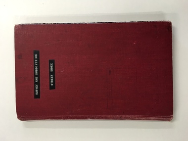
Register, Survey & subdivision street index, 1930s
This is a book with the City of Warrnambool surveys and subdivisions listed under the street names. It covers the period from 1938 to 1975. The information is listed under the headings of plan number, street name, section, allotment, date and remarks. The information contained therein would now be held as electronic data in the Council Records Department. Warrnambool, founded in 1847, became a municipality in 1856, a Borough in 1863, a Town in 1883 and a City in 1918. This book is of considerable interest because it lists Warrnambool streets from 1938 to 1975 and gives details of the subdivisions and surveys during that time. It will be very useful for researchers. This is a foolscap-size hard-cover book with a red cover with a mottled-blue pattern paper inside the covers. It has 95 pages with ruled red and blue lines. It has a handwritten alphabet index throughout the pages. The contents are handwritten in blue, green and black ink. The inside binding has been mended with adhesive tape and one page is loose. The book lists subdivisions in the City of Warrnambool under the heading of the street names and covers 1938 to 1975. The cover is somewhat grubby.Front Cover (in plastic tape): ‘Survey and Subdivision. Street Index’warrnambool city council, warrnambool streets and subdivisions -
 Warrnambool and District Historical Society Inc.
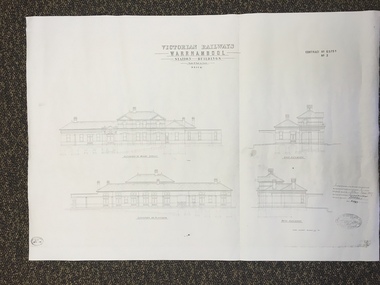
Map, Victorian Railway W'bool No1 & No2, 1897
These two sheets show the 1897 plans drawn up by the Victorian Railways for the erection of the Warrnambool Railway Station building. It is a two-storey building still existing today. The railway came to Warrnambool in 1890 and they must have used temporary buildings for seven years before this railway building was erected. It had offices, booking counter and public facilities on the ground floor and housing for the Station Master on the first floor. The building erected was a typical design for country town railway stations and many of similar design were erected in the 1880s and 90s. These plans are important because they show clearly the design of the Warrnambool Railway Station buildings when they were first erected in the 1890s.They will be very useful for researchers. The coming of the railway was a significant event in Warrnambool’s history and did much to make the port and shipping a less viable proposition.These are two architect’s plans and drawings of the Warrnambool Railway Station building (1897). The drawings are black and white and the first plan shows the ground floor plan and the first floor plan and the outbuildings. The second plan shows drawings of the building with its elevation to the platform and its elevation to Merri Street. There are two stamps of the Railways Department, Melbourne. These are copies, not originals. ‘Victorian Railways, Warrnambool, Station Buildings, Scale 8 feet to one inch, Contract No. 6379B (Nos. 1 and 2)’warrnambool, railway station buildings -
 Warrnambool and District Historical Society Inc.
Map, Plans (5) showing Subdivisions of Warrnambool, 1989
... Street (south of Merri St) Warrnambool great-ocean-road ...These plans have been drawn by Steve Hester for the Warrnambool City Council to illustrate the allotments in Warrnambool concerned with the subdivisions of 1989. The streets have not been named but there is an indication of the area with the identification of known buildings (eg Hospital) and the plan numbers of each allotment is clearly marked. These numbers corresponded to the plan numbers registered in card files and ledgers in the Warrnambool City Council offices. The scale of the plans was 1 to 5000. These plans are of considerable interest because they show Warrnambool street subdivisions of 1989 in illustrative form. They show how information was collated in the late 1980s before the widespread use of computer digital means to describe and store information.These are five hand-drawn sheets showing plans of sub-divisions in Warrnambool streets in 1989 (Warrnambool City Council material). The plans are multi-coloured (crayons) and show allotments with plan numbers. The first plan has much of the material torn off but the location is known to be in the Russells Creek area. Some of the green tape around the edges is missing. Plans two to five are almost intact and are bound with green tape. Plan Two- Industrial Estate of West Warrnambool; Plan Three – Hospital/Merrivale/ Lake Pertobe areas; Plan Four – North Warrnambool, Wollaston/Brierly areas; Plan Five – Flaxman Street area. ‘Subdivision Plan, Reference Guide, Steve Hester, Oct. 1989’. warrnambool street subdivisions, steve hester, history -
 Warrnambool and District Historical Society Inc.
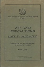
Booklet, Air Raid Precautions, 1941
This booklet was published on the recommendation of the Commonwealth government as part of a plan to offer protection to the people in the event of air strikes. Local councils and individuals were called to help to protect themselves in taking precautions,. The booklet itself sets out action to be taken in the event of an air raid happening, lighting restrictions fire prevention, refuge rooms and garden shelters and risks from air raids. It contains the relevant siren signals which denote different types of events and explains in detail various aspects of preparing for possible attack. There was discussion about issues such as evacuation of children should such an event occur with the focus primarily on the larger centres such as Geelong and Melbourne. From 1942 the number of air attacks increased mainly from Japan on the northern and western parts of Australia including over 60 on Darwin. Attacks continued into 1943 and it wasn’t until later in that year that the Prime Minister, John Curtin announced that the threat of invasion had passed.While the link to Warrnambool’s history is tenuous, it was a government publication to all persons in the state of Victoria in 1941.This item relates to a significant period in Australia’s history. All Australians were affected by the war. It has historical and scientific or research interest as it gives a number of diagrams and possible plans and the effectiveness of same. Olive green soft card cover with black text. 36 pages, with 2 extra pages depicting plans for shelters pasted inside back cover. Victorian coat of arms at top of cover.April 1941. H. E. Daw, Government printer. Forward by Sir John Harris KBE MLC Minister of Public Instruction and Public Healthhistory of warrnambool, air raid precautions 1941 -
 Warrnambool and District Historical Society Inc.
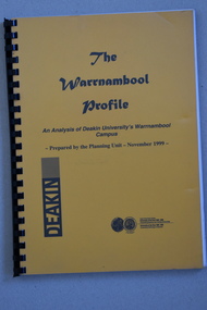
Booklet Lettering Book, Deakin University Planning Unit, The Warrnambool Profile – An Analysis of Deakin University’s Warrnambool Campus, 1999
This booklet was prepared in 1999 by the Planning Unit of Deakin University. It gives current data on the campus and projections and suggestions for the future. The Warrnambool Campus of Deakin University was established in 1990 after a merger with the Warrnambool Institute of Advanced Education which was already on the site that the university still occupies. This is Sherwood Park, a 94 hectare site on the Princes Highway, five kilometres from Warrnambool.This booklet is of some interest as it contains information on the Warrnambool Campus of Deakin University ten years after it was first established. This is a soft cover booklet of 179 pages. It has an orange front cover and a black back cover with black printing and a plastic over-sheet. The booklet has printed information, tables and graphs. It has black plastic spiral binding. deakin university, warrnambool campus -
 Warrnambool and District Historical Society Inc.
Ledger, Chadwick Copying Book Co, Letter book 1905, 1902
This letter book has maps, letters and plans dating from 1902 to 1905. It came from the office of John William Crawley, Junior, an engineer, architect and surveyor in private practice in Warrnambool and also the engineer for the Shire of Warrnambool from 1895 to 1935. His father, brother and son were all engineers and worked in that capacity or as Shire Secretary for the Shire of Warrnambool, with the Crawley family recording a total of 132 years of service to the Shire of Warrnambool. The Shire of Warrnambool existed from 1863 to 1994. This letter book was passed on to John Crawley’s son, Rolf, engineer for the Shire of Warrnambool from 1935 to 1968. The letter book then came into the possession of Michael Hand who took over the private surveying business of Rolf Crawley in Warrnambool. The Warrnambool and District Historical Society acquired the letter book, along with several other Crawley ledgers, from the Michael Hand estate. This letter book is of considerable importance as it contains the letters, maps and plans produced by John William Crawley Junior, a Shire of Warrnambool engineer for 40 years. It will be useful to researchers. This is a black hard cover letter book of 505 pages, plus an alphabetical index at the back of the book. The letter book contains handwritten letters, sketch maps and plans. There is gold lettering on the spine.‘1’ ‘Invoice’ ‘Chadwick Copying Book Co. Springfield Mass.’ john william crawley, junior, warrnambool, rolf crawley, warrnambool, shire of warrnambool, history of warrnambool -
 Warrnambool and District Historical Society Inc.
Ledger, Letter book 1892-1904, 1892
This letter book has letters, sketch maps and plans and dates from 1892 to 1904. It came from the office of John William Crawley, Junior, an engineer, architect and surveyor in private practice in Warrnambool and also the engineer of the Shire of Warrnambool from 1895 to 1935. His father, brother and son were also engineers and worked in that capacity or as the Shire Secretary for the Shire of Warrnambool, with the Crawley family recording a total of 132 years of service to the Shire. This letter book was passed on to John Crawley’s son, Rolf Crawley, Engineer for the Shire of Warrnambool from 1935 to 1968. The letter book then came into the possession of Michael Hand who took over the private surveying business of Rolf Crawley in Warrnambool. The Warrnambool and District Historical Society has acquired the letter book, one of several Crawley ledgers, from the Michael Hand estate. This letter book is of considerable significance as it contains maps, plans, sketches and written information which is the work of John William Crawley Junior, the engineer for the Shire of Warrnambool for 40 years. It will be very useful to researchers. This is a hard cover letter book of 500 pages. The cover is black with leather binding on the edges of the cover and on the spine. The pages contain an alphabetical listing of the letters, handwritten letters and many sketch maps and plans. There are several loose pages of plans and diagrams at the back of the book. The inside of the covers has a blue mottled pattern. The edges of the cover are torn. There is a mauve stamp on the first page. ‘Letter Book 1892 to 1901’ ‘Rolf L. Crawley, Civil Engineer, Drainage and Water Supply Engineer, Licensed Surveyor, Registered Architect, Warrnambool’ john william crawley, junior, warrnambool, rolf crawley, warrnambool, shire of warrnambool -
 Warrnambool and District Historical Society Inc.
Letter Book 3, 1901 - 1908, 1900
This letter book has letters, plans and maps and dates from 1901 to 1908. It came from the office of John William Crawley, Junior, an engineer, architect and surveyor in private practice in Warrnambool and also the engineer for the Shire of Warrnambool from 1895 to 1935. His father, brother and son were also engineers and worked in that capacity or as the Shire Secretary for the Shire of Warrnambool, with the Crawley family recording a total of 132 years of service to the Shire. The letter book was passed on to John Crawley’s son, Rolf, engineer for the Shire of Warrnambool from 1935 to 1968. The letter book then came into the possession of Michael Hand who took over the private surveying business of Rolf Crawley in Warrnambool. The Warrnambool and District Historical Society has acquired the letter book, one of several Crawley ledgers, from the Michael Hand estate. The Shire of Warrnambool existed from 1863 to 1994. This letter book is of considerable significance as it contains maps, plans and letters produced by John William Crawley Junior, the engineer for the Shire of Warrnambool for 40 years. It will be very useful for research. This is a hard cover letter book of 717 pages. It has a black cover with brown leather binding on the cover edges and spine. The leather is worn away in places. The letter book contains an alphabetical index, handwritten letters, sketch plans and maps. There is a mauve stamp on the inside front cover. ‘3’ ‘Letter Book 1901 to 1908’ ‘Letter Book J.Wm. Crawley’ ‘Rolf L. Crawley, Civil Engineer, Drainage and Water Supply Engineer, Licensed Surveyor, Registered Architect, Warrnambool’ john william crawley junior, warrnambool, rolf crawley, warrnambool, history of warrnambool -
 Warrnambool and District Historical Society Inc.
Letter Book 4, 1901, 1908
This letter book has letters, invoices, sketch maps and plans and dates from 1908 to 1910. It came from the office of John William Crawley Junior, an engineer, architect and surveyor in private practice in Warrnambool and also the official engineer of the Shire of Warrnambool from 1895 to 1935. His father, brother and son were also engineers and worked in that capacity or as the Shire Secretary for the Shire of Warrnambool, with the Crawley family members recording a total of 132 years of service to the Shire. The letter book was passed on to John Crawley’s son, Rolf, Engineer for the Shire of Warrnambool from 1935 to 1968. The letter book then came into the possession of Michael Hand who took over the private surveying business of Rolf Crawley in Warrnambool and the Warrnambool and District Historical Society has acquired the letter book, one of several Crawley ledgers, from the Michael Hand estate. This letter book is of considerable significance as it contains maps, plans, sketches and written information on the work of John William Crawley, the engineer for the Shire of Warrnambool for 40 years. This is a black-covered letter book with copies of letters and field maps and plans and an alphabetical listing at the front. Some of the letters are invoices for work carried out. The leather section of the front cover has been almost completely torn away and the binding is mended with adhesive tape. There are some torn pages. The front page has a signature and a mauve stamp. ‘Letter Book’ ‘J.Wm. Crawley (Private)’ ‘ Rolf L. Crawley, Civil Engineer, Drainage and Water Supply Engineer, Licensed Surveyor, Registered Architect, Warrnambool’ ‘4’ rolf crawley, warrnambool, john william crawley, junior, warrnambool, history of warrnambool -
 Warrnambool and District Historical Society Inc.
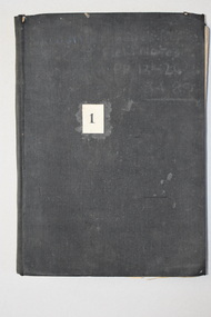
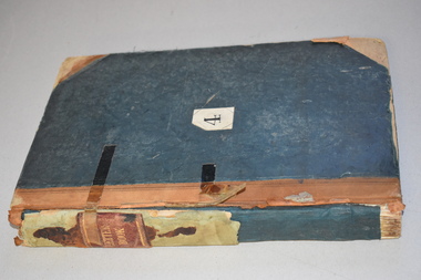
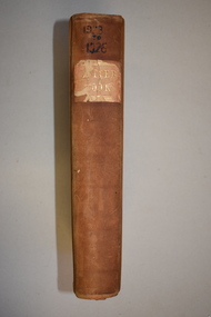
Letter book 6, Jan 1914 - 1917, 1914
This letter book contains letters, plans and sketch maps dating from 1914 to 1917. It came from the office of John William Crawley Junior, an engineer, architect and surveyor in private practice in Warrnambool and also the engineer for the Shire of Warrnambool from 1895 to 1935. His father, brother and son were also engineers and worked in that capacity or as the Shire Secretary for the Shire of Warrnambool, with the Crawley family recording a total of 132 years of service to the Shire of Warrnambool. This Shire existed from 1863 to 1994. The letter book was passed on the John Crawley’s son, Rolf, engineer for the Shire of Warrnambool from 1935 to 1968. It then came into the possession of Michael Hand who took over the private surveying practice of Rolf Crawley in Warrnambool. The Warrnambool and District Historical Society has acquired the letter book, along with several other Crawley ledgers, from the Michael Hand estate. This letter book is of considerable significance as it contains letters, maps and plans drawn up by John William Crawley, Junior, the engineer for the Shire of Warrnambool for 40 years. It will be very useful for researchers. This is a brown hard cover letter book with leather binding on the edges of the cover and on the spine. The leather is worn away in several places. There is gold lettering on the spine. The book has 750 pages of handwritten letters, maps and plans. The inside cover is of a mottled blue colour. There is an alphabetical index at the beginning of the book. ‘6’ ‘Letter Book 1914 to 1917’ john william crawley junior, warrnambool, rolf crawley, warrnambool, shire of warrnambool -
 Warrnambool and District Historical Society Inc.
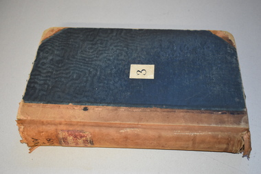
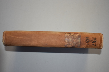
Letter book 7, 1917-1920, 1917
This letter book contains handwritten letters, sketch maps and plans and dates from 1917 to 1920. It comes from the office of John William Crawley Junior, an engineer, architect and surveyor in private practice in Warrnambool and also the engineer for the Shire of Warrnambool from 1895 to 1935. His father, brother and son were also engineers and worked in that capacity or as Shire Secretary for the Shire of Warrnambool, with the Crawley family recording 132 years of service with the Shire of Warrnambool. The Shire existed from 1863 to 1994. The letter book was passed on to John Crawley’s son, Rolf, the engineer for the Shire of Warrnambool from 1935 to 1968. The letter book then came into the possession of Michael Hand who took over the private surveying business of Rolf Crawley in Warrnambool. The Warrnambool and District Historical Society then acquired this letter book, along with other Crawley ledgers, from the Michael Hand estate. This letter book is of considerable significance as it contains letters, plans and maps drawn up John William Crawley Junior, the engineer for the Shire of Warrnambool for 40 years. It will be very useful for research. This is a hard cover book of 745 pages. It has leather trim on the cover edges and the spine with gold lettering on the spine. The leather covering is scuffed and torn. The inside covers have a mottled blue lining. The book contains maps, plans and handwritten letters and has an alphabetical index at the beginning of the book. Most of the pages have been water-stained. ‘7 Private’ ‘Letter Book 1917 to 1920’john william crawley junior, warrnambool, rolf crawley, warrnambool, shire of warrnambool -
 Warrnambool and District Historical Society Inc.
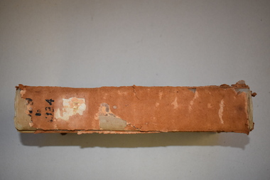
Letter book 13, 1920
This letter book contains letters, sketch maps and plans and dates from 1920 to 1923. It came from the office of John William Crawley Junior, an engineer, architect and surveyor in private practice in Warrnambool and also the engineer for the Shire of Warrnambool from 1895 to 1935. His father, brother and son were also engineers and worked in that capacity or as the Shire Secretary for the Shire of Warrnambool, with the Crawley family recording a total of 132 years of service to the Shire. The letter book was passed onto John Crawley’s son, Rolf, the engineer for the Shire of Warrnambool from 1935 to 1968. It then came into the possession of Michael Hand who took over the private surveying business on Rolf Crawley in Warrnambool. The Warrnambool and District Historical Society acquired the letter book, along with several other Crawley ledgers, from the estate of Michael Hand. This letter book is of considerable significance as it contains letters and maps drawn up by John William Crawley, an engineer in the Shire of Warrnambool for 40 years. It will be very useful for researchers.This is a dark red hard- cover letter book of 1001 pages. The book has brown binding on the corners of the cover and on the spine. There is gold lettering on the spine. The inside of the cover is lined with a multi-coloured mottled pattern. The cover is stained and scuffed. The pages contain handwritten letters, sketch maps and plans and an alphabetical index at the front. There are three loose pages. There is a mauve stamp on the first page.‘Letter Book 1920 to 1923’ ‘Rolf. L. Crawley Civil Engineer, Drainage and Water Supply Engineer, Licensed Surveyor, Registered Architect, Warrnambool’ john william crawley junior, warrnambool, rolf crawley, warrnambool, shire of warrnambool -
 Warrnambool and District Historical Society Inc.
Letter book 14, 1923
This letter book contains letters, sketch maps and plans and dates from 1923 to 1926. It came from the office of John William Crawley, Junior, an engineer, surveyor and architect in private practice in Warrnambool and also the engineer for the Shire of Warrnambool from 1895 to 1935. His father, brother and son were also engineers, working in that capacity or as the Shire Secretary for the Shire of Warrnambool, with the Crawley family recording a total of 132 years of service to the Shire. The Shire of Warrnambool existed from 1863 to 1994. This letter book was passed on to John Crawley’s son, Rolf, the engineer for the Shire of Warrnambool from 1935 to 1968. It then came into the possession of Michael Hand who took over the private surveying business of Rolf Crawley in Warrnambool. The Warrnambool and District Historical Society acquired the letter book, along with several other Crawley ledgers, from the estate of Michael Hand.This letter book is of considerable significance as it contains letters, maps and plans drawn up by John William Crawley, an engineer and surveyor in private practice in Warrnambool and the engineer for the Shire of Warrnambool for 40 years. It will be useful for researchers. This is a brown hard cover letter book of 1010 pages, with brown binding on the corners of the cover and on the spine. The cover is cuffed and torn. There is gold lettering on the spine. The book contains handwritten letters, maps and plans and an alphabetical index at the front, The pages are water-stained. There is a mauve stamp on the first page.‘Letter Book 1923 to 1926’ ‘J. Wm. Crawley Shire Hall Warrnambool (Private)’ ‘Rolf L. Crawley Civil Engineer, Drainage and Water Supply Engineer, Licensed Surveyor, Registered Architect, Warrnambool’ john william crawley junior, warrnambool, rolf crawley, warrnambool, shire of warrnambool -
 Warrnambool and District Historical Society Inc.
Letter book 15, 1920s
This letter book contains letters, sketch maps and plans and dates from 1929 to 1934. It came from the office of John William Crawley Junior, an engineer, surveyor, and architect in private practice in Warrnambool and also the engineer for the Shire of Warrnambool from 1895 to 1935. His father, brother and son were also engineers, working in that capacity or as Shire Secretary for the Shire of Warrnambool, with the Crawley family recording a total of 132 years of service to the Shire. The Shire of Warrnambool existed from 1863 to 1994. The letter book was passed on to John Crawley’s son, Rolf who was the engineer for the Shire of Warrnambool from 1935 to 1968. It then came into the possession of Michael Hand who took over the private surveying business of Rolf Crawley in Warrnambool. The Warrnambool and District Historical Society acquired the letter book, along with several other Crawley ledgers, from the estate of Michael Hand. This letter book is of considerable importance as it contains letters and maps from the late 1920s and 1930s and was compiled by John Crawley Junior, an engineer in the Shire of Warrnambool for 40 years. It will be a useful research tool. This is a hard-cover letter book of 1005 pages. It contains an alphabetical index at the front, handwritten letters, sketch maps and plans and some loose sheets. It has brown leather binding on the corners of the cover and on the spine but the spine covering is completely detached. The gold lettering on the spine is now almost completely obliterated. The cover is scuffed and torn. ‘Private Book’ ‘1929 to 1934’ john william crawley junior, warrnambool, rolf crawley, warrnambool, shire of warrnambool -
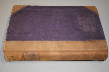
 Warrnambool and District Historical Society Inc.
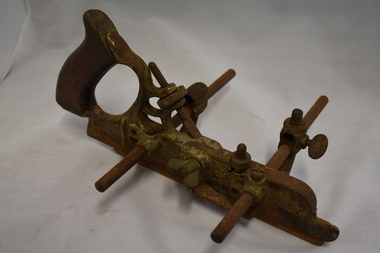
Tool - Builder's plane, Wood plane, Early 20th century
This wood plane would have been used in the past both in industry and in the home. It is an early example of a plane and has antiquarian interest. This item has no known local provenance but is retained as a good example of a vintage tool used in the past by carpenters and handymen. This is a metal tool for planing wood. It has a rectangular wooden base and two side bars for adjusting the length and angle of the blade. The tool has several metal wing nuts and screws and a wooden handle. The metal is much rusted. ‘Trade Mark 45’carpentry tools, history of warrnambool -
 Warrnambool and District Historical Society Inc.
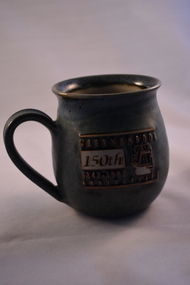
Household, Souvenir Cup (Warrnambool’s 150th ), 1997
This cup was produced by Ken Sadler as a souvenir of the 150th anniversary of the settlement of Warrnambool. Ken Sadler was a potter in Liebig Street, Warrnambool for many years (end of 20th century and beginning of 21st century). Warrnambool was founded as a planned town in 1847 to provide port facilities for the produce of squatters who had settled in the area. The town centre was surveyed by William Pickering at the request of Superintendent La Trobe of Melbourne and the first land sales were held in Melbourne in July 1847. The celebrations to mark the 150th anniversary of Warrnambool included concerts, race meetings, church services and the erection of an anniversary tablet on Cannon Hill. Ken Sadler, a well-known Warrnambool potter, made 500 of these cups which are now collectible souvenirs of the city’s 150th anniversary celebrations. This one retained by the Warrnambool and District Historical Society is numbered 189. The 150th anniversary of the founding of Warrnambool was an important event in the city’s history.This is a ceramic cup with a round base and larger rounded body with a round overhanging rim at the top opening. The cup is mottled green with an impressed image of a ship and lettering in white, gold and brown. There is some lettering on the bottom of the cup.‘Warrnambool 150th Anniversary 1847-1997’ ‘Sadler 97 189/500 Warrnambool’ warrnambool’s 150th anniversary, history of warrnambool, ken sadler, warrnambool potter -
 Warrnambool and District Historical Society Inc.
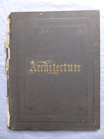
Book, Architecture, 1870s
This book belonged to John William Crawley an engineer, architect and surveyor who was appointed District Engineer for the Public Works Department in the Western District in 1866. He was the Shire of Warrnambool Engineer from 1874 to 1895 when he was succeeded by his son. This book is of minor importance as a memento of John William Crawley an important engineer in the Shire of WarrnamboolThis is a hard cover book with pages containing architectural plans,designs and printing. Some of the pages are blank.The cover is faded and spotted and has a gold title The spine is damaged .Inside the front cover is an inscription and on the following page is another inscription.J.W Crawley 1879 Architecture john william crawley, shire of warrnambool -
 Warrnambool and District Historical Society Inc.
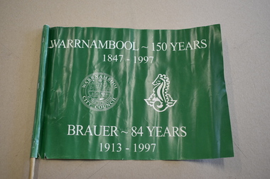
Artefact, Flag, 1997
This small flag has been made by Brauer College in Warrnambool to celebrate the 150th anniversary of the founding of Warrnambool and to mark the 84 years of Brauer College’s existence. Warrnambool was founded in 1847 as a planned town to provide port facilities for the export of produce of the local pastoralists and squatters. Brauer College began as the Warrnambool Technical School in 1913 with John King as the Principal and the original school buildings in Timor Street. In 1958 the school became the Warrnambool Technical College and today this site is occupied by the South West TAFE facility. The secondary school section of Warrnambool Technical College relocated to Caramut Road in Warrnambool and since 1990 has been known as Brauer College. It was named after a local prominent doctor and supporter of State Education – Dr Alfred Brauer. This flag is of some interest as a memento of Warrnambool’s 150th anniversary and of Brauer College’s part in this. This is a rectangular-shaped plastic flag attached with three metal staples to a circular-shaped wooden stick. The flag is green with white printing on both sides and contains the images of the Warrnambool City Council seal and the sea-horse emblem of Brauer College. The flag is partly torn away from the stick at the lower end. ‘Warrnambool -150 years 1847-1997’ ‘Brauer – 84 years 1913-1997’ brauer college, warrnambool, warrnambool’s 150th anniversary -
 Warrnambool and District Historical Society Inc.
Document (Sketch Plan of Dunmore), Stan Baulch, 1972
This card has a sketch map showing the properties surrounding Dunmore on one side and a detailed sketch plan of Dunmore homestead in the early 1970s on the other side. The plan of Dunmore homestead shows interesting features such as the brick oven for bread making, the croquet lawn, the site of the aboriginal mia mias, the Turkish baths and the fowl house used later as a poison house. Francis and Ann Baulch were pioneer settlers in the Kirkstall area and their son Samuel worked at Dunmore in the Macarthur area before purchasing in the early 1870s the property he named Rose Park. In the 1890s he acquired property in the Dunmore estate and his son Stan Baulch gained a section of the Dunmore property after his father’s death. Stan Baulch named this Dunmore section, Rose Park, a property to the west of his father’s original Rose Park property. Stan Baulch was a long time member of the Warrnambool & District Historical Society and he contributed many local history articles and donated many local artefacts to the Society.This sketch plan is of interest as it tells us what the historic homestead of Dunmore in Western Victoria was like in the early 1970s. It will be useful for research. This is a sheet of white lightweight cardboard with a pencilled sketch on one side and a blue ink sketch plan of a house on the other side. The edges of the card have some torn sections. The card is enclosed in an oval cardboard cylinder (recycled and torn at the ends). Both the card and the cover have handwritten titles in ink. Dunmore Homestead & History by S. Baulch Dunmore Homestead drawn by Stan Baulch c.1972 dunmore property, western victoria, baulch family -
 Warrnambool and District Historical Society Inc.
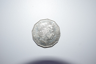
Coin, 50 Cents Centenary of Federation, 2001
This coin was issued to commemorate the centenary of Federation in Australia in 2001. The six Australian States were federated into the Commonwealth of Australia in January 1901 after several years of campaigning and planning. The first Prime Minister was Edmund Barton and the first Federal Parliament was held in Melbourne and continued to be held in Melbourne until the establishment of the Australian capital at Canberra in 1927. In 2001 ceremonies and celebrations were held all over Australia to commemorate the centenary of Federation. This coin is retained for display purposes as a souvenir of the centenary of Federation in AustraliaThis silver-coloured 12-sided coin has an image of Queen Elizabeth 11 and etched printing on one side and a Coat of Arms and printing on the other side. Elizabeth 11 Australia 2001 Centenary of Federation 1901 - 2001 New South Wales Fifty Cents federation in australia, history of warrnambool, coin -
 Warrnambool and District Historical Society Inc.
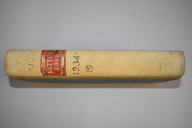
Letter book, J & R Crawley, 1934
This letter book contains letters, sketch maps and plans and dates from1934 to 1936. It originally came from the office of John William Crawley Junior, an engineer, surveyor and architect in private practice in Warrnambool and also the Shire Engineer for the Shire of Warrnambool from 1895 to 1935. His father, brother and son were also engineers and worked in that capacity or as the Shire Secretary for the Shire of Warrnambool, with the Crawley family recording a total of 132 years of service to the Shire. The Shire of Warrnambool existed from 1863 to 1994. The letter book was also used in the private practice of John Crawley’s son, Rolf who was the engineer for the Shire of Warrnambool from 1935 to 1968. The letter book then came into the possession of Michael Hand who took over the private surveying business of Rolf Crawley in Warrnambool. The Warrnambool and District Historical Society acquired the letter book, along with several other Crawley ledgers, from the estate of Michael Hand.This letter book is of considerable significance as it contains letters written by John Crawley and Rolf Crawley who were in an engineering, surveying and architects private practice in Warrnambool over the time covered in the book. It will be very useful to researchers. This is a hard cover book of 1000 pages but only 354 pages have been used. The cover is bound at the corners and on the spine with buff-coloured leather. The book contains an alphabetical index, handwritten letters, sketch maps and plans. ‘Private Letter Book 1934- 19.’ ‘R.L./J. W. Crawley Private’ john william crawley junior, warrnambool, rolf crawley, warrnambool, shire of warrnambool -
 Warrnambool and District Historical Society Inc.
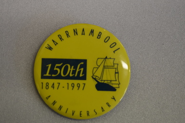
Badge, Warrnambool 150th 1847-1997
This badge was produced in 1997 as a souvenir of the 150th anniversary of the founding of Warrnambool. Warrnambool was a planned town, established in 1847 as a port to service the squatters who had taken up large tracts of land in the Warrnambool area in the 1840s.The town was surveyed by the Government surveyor William Pickering at the request of Superintendent La Trobe and the first town lots of the new town were sold in Melbourne in 1847, with some settlers arriving at the new settlement soon after.This badge is one of the many souvenirs of the 1997 celebrations in Warrnambool Circular concave metal badge with blue drawing of a sailing ship and text. There is a clip pin on the reverse.WARRNAMBOOL ANNIVERSARY 150th 1847 -1997 -
 Warrnambool and District Historical Society Inc.
Documents, Late 20th, early 21st centuries
These ten documents (maps, plans, photographs) mostly come from the Warrnambool City Council and most contain information on sub-divisions and titles of properties in areas around the Central Business District of Warrnambool. The dates range from 1986 to 2006. These maps, plans and photographs are of some interest as they give historical details of subdivisions in Warrnambool and date from the late 20th century. .1 This is a laminated map of the boundaries of Local Governments in Victoria. It is Sheet I of 2 and has red and blue pencil markings and black boundary markings. .2 This is a copy of a plan of a survey in black and white markings on paper. .3 This is a plan of the title details of Section 19 Warrnambool. It has black printing on buff-coloured paper. .4 This is a plan of the allotments in part of the Central Business District of Warrnambool. It is printed in black and white. .5 This is a 2006 coloured aerial photograph of the harbour at Warrnambool – Breakwater etc. .6 This is a 2006 coloured aerial photograph of the Lake Pertobe area in Warrnambool .7 This is a coloured aerial photograph of Warrnambool’s streets over-stamped with road numbers in large blockings. .8 This is a plan showing the title details of Section 11 in Warrnambool. It has black printing on buff-coloured paper. .9.1 This is a plan of sub-divisions in parts of Crown Allotments 38 & 39 in Warrnambool. It has green, pink and yellow markings with black printing. .9.2 This is a plan of the sub-divisions in parts of Allotments 38 & 39 in Warrnambool. It has pink, yellow and blue markings with black printing. It is somewhat faded. warrnambool c.b.d. maps and plans, history of warrnambool