Showing 633 items matching "runs"
-
 Clunes Museum
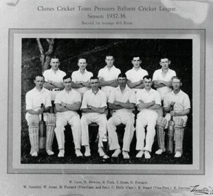
Photograph - PHOTOGRAPH CRICKET 1937/38, THORNTON STUDIOS, BALLARAT, 1937 - 38
SEE OVER.1 BLACK AND WHITE COPY PHOTOGRAPH OF CLUNES CRICKET TEAM .2 SEPIA COPY PHOTOGRAPH OF CLUNES CRICKET TEAM .3 BLACK AND WHITE CIPY PHOTOGRAPH OF CLUNES CRICKET TEAM FIXED TO MATTE BOARD PREMIERS BALLARAT CRICKET LEAGUE SEASON 1937 - 38 RECORD FIRST INNINGS 418 RUNSphotographs, cricket, cricket 1937/38 -
 Bendigo Historical Society Inc.
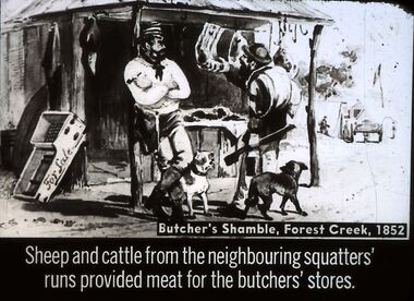
Slide - DIGGERS & MINING. STORES AT THE DIGGINGS, c1852
Diggers & Mining. Stores at the diggings. Butcher's Shamble, Forest Creek, 1852. Sheep and cattle from the neighbouring squatters' runs provided meat for the butchers' stores. Slide shows miner checking out the meat for sale other items are also for sale. Markings: 23 994.LIF. 5. Used as a teaching aid.hanimounteducation, tertiary, goldfields -
 Port Fairy Historical Society Museum and Archives
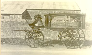
Photograph
Guyett and Sons builders, and Undertakers occupied a shop in Sackville Street Port Fairy now owned by Brooke's. The property runs through to Princes Street more commonly known as 'Coffin Alley' because the buildings a t the back were used by the undertaking part of the business.Black and white photographtransport, rail, road, guyetts undertakers, buildeers, sackville street, hearse, wagon -
 Kew Historical Society Inc
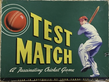
Leisure object - Board game, Test Match: A fascinating cricket game, 1955
'Test Cricket' was one of the most popular board games in the pre television era. John Sands Pty Ltd, the publisher, was an Australian bookseller and stationer founded in 1837 and produced board games from 1929-78.Board game consisting of a rectangular cardboard piece illustrated with a cricket ground, players and a scoreboard. Two semi-circles have been cut away from the background and are used to control the progress of the game. The right hand game control is moved to 'ball' position (1-8) and back to start which indicates the type of delivery shown in the window. The left hand control is moved to 'type of delivery bowled' and back to the start which reveals the number of runs scored or method of dismissal which is shown in the window. The scoreboard is operated by three circular wheels that show the result of runs and wickets. An oval handle is at the upper centre. The packaging includes a green cardboard box with lid, which has an image of a batsman and a red cricket ball.board games, john sands pty ltd, cricket -
 The Beechworth Burke Museum
Photograph, c.1927-1930
This image shows the Punt (a kind of small boat) that took residents of Bethanga across the Murray River before the Bethanga Bridge was built. Bethanga Bridge was built between 1927 and 1930, and was made a necessity by the building of the Hume Dam. The Hume Dam, formerly known as the Hume Weir, was in construction between 1919 and 1936, which swelled the Murray River into the floodplain to the East of the dam permanently, creating Lake Hume, and isolating the residents of Bethanga and nearby towns, for whom the trip all the way around the new lake to another river crossing was a massive undertaking. The person who wrote on the back of this card instead chose to cross the river on a boat until the Bethanga Bridge became available. Interestingly, partially submerged trees can be seen in the lake in the background of this photograph, illustrating that the dam had already begun to fill the floodplain even before the bridge was built. This photograph shows the methods the residents of Bethanga used while the Bethanga Bridge was being built. This record is associated with the Heritage Listed sites of the Hume Dam and the Bethanga Bridge, and shows the environment during the process of construction and the creation of Lake HumeSepia rectangular photograph printed on matte photographic paperReverse: 1997.3189 / 84 -19 -1 / This is the snap of the Punt. / Our only means of getting out / of Bethanga for the present / Until the bridge is completed / it is 2 miles above the junction / of the Mitta + Murray. It is / 1/2 a mile wide + runs across / the Murray into NSW / Kodak Print / bethanga, bethanga bridge, hume, hume dam, artificial lake, lake hume, hume weir, flood, floodplain, boat, punt, weir, pier, dock, transport, transportation -
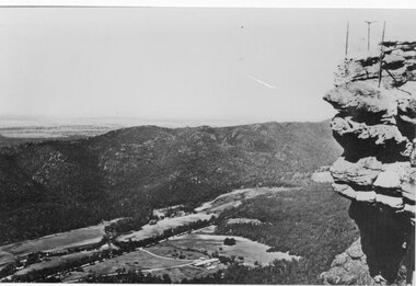 Halls Gap & Grampians Historical Society
Photograph - B/W, C 1950s (?)
Photograph is of Fyans Valley taken from Bellfield Peak. The mountain range across the centre of the scene runs north to south. The large dwelling centre-front is Bellfield Hotel, which was destroyed by fire in the 1960s. The main road running through the middle of the valley is Grampians Road.A rocky outcrop, far right, with metal fence and posts. View of a valley with cleared land, roads and buildings in foreground. Further cleared land can be seen beyond a mountain range that is in the centre of the photograph.scenery, fyans valley -
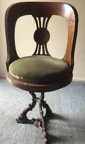 Queenscliffe Maritime Museum
Furniture - Chair
The SS Edina's active service included the North Sea trade, ‘Crimean War’, ‘American Civil War’, Victoria’s west coast run, New Zealand to Melbourne trade, Queensland coastal trade, and of course, the Port Phillip Bay runs between the years 1880 to 1938.A saloon swivel timber chair with green velvet cushion and cast iron base from the SS Edinachair, steamers, ss edina -
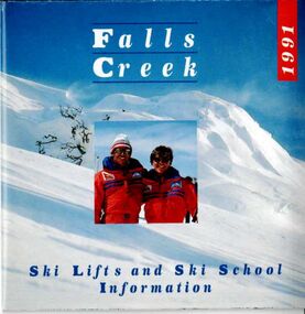 Falls Creek Historical Society
Booklet - Brochure - 1991 Falls Creek Ski Lifts and Ski School Information
Part of a yearly marketing and information material promoting Falls Creek ski region for the winter holidays. This is a small fold out guide to ski lifts, tariffs, ski runs and a map of Falls Creek. It also includes basic safety instructions and a promotion for the Frying Pan Inn.This item is important because it documents seasonal activities at Falls Creek Alpine ResortA small folded brochure promoting the Falls Creek Ski Lifts and Ski Schoolwinter sport, falls creek marketing, falls creek ski lifts -
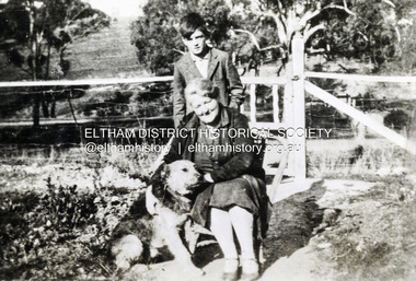 Eltham District Historical Society Inc
Photograph, Beatrice Arrowsmith (nee Quigley) and Robert Arrowsmith and King the dog at front gate of 523 Main Road, Eltham
View is looking south west from inside the front gate. Main Road is running across the picture just past the trees and the open area is where the current day Fitzsimons Lane runs. Porter street is adjacent to the property on the right of image. Robert was a POW in ChangiShows the area of Fitzsimons Lane prior to developmentBlack and white photograph - digital fileeltham, main road, fitzsimons lane, porter street, castledine, beatrice arrowsmith (nee quigley), king (dog), robert arrowsmith, joan castledine collection -
 Bialik College
Mixed media (Item) - 2006 Kindergarten commemoration for K3E
A cd-rom titled 'Elise Rotstayn' created to commemorate the events of 3 year old kinder in 2006. Notes that this cd-rom of coloured and black and white photographs are of the children of K3E. The video runs for 10:24. Please contact [email protected] to request access to this record.A special year in three year old kindergarten 20062006, 2000s, kindergarten, bialik college -
 Melbourne Tram Museum
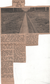
Newspaper, Herald Sun, "Rough, but they like it", 1955
The article and photo report on the poor condition of the Victorian Railways tram tracks and the possible closure of the Sandringham to Black Rock tram line. Notes the passengers wish to keep the line and while the track is poor, the service runs on time. The tram line was closed on 5/11/1956.Yields information about the Sandringham to Black Rock line prior to the tramway closure.Newspaper clipping titled - "Rough, but they like it" - Melbourne Herald 5/11/1955"Melb "Herald" Sat 5 Nov 1955"trams, tramways, vr trams, track maintenance, tram tracks, sandringham to black rock -
 Stawell Historical Society Inc
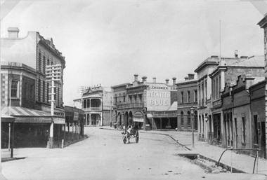
Photograph, Main Street Stawell looking West from Layzell Street c1900's
Main St. Scenes looking West from Layzell St. J Chadwick Drapers sign visible. Patrick Street runs off to the left of the photo. Horse drawn buggy in centre of roadway. Circa 1900's. George Whight's shop is visible on right centre.stawell businesses streetscape -
 Bendigo Historical Society Inc.
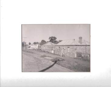
Photograph - HARVEY TOWN, EAGLEHAWK, 1960's ?
Black and white photograph: streetscape of Harvey Town, Eaglehawk. Dirt road, with dirt footpath. Two stone cottages on RH side of photo, white painted stone ( ? ) cottage with a verandah on LH side of photo. Cottages have iron roof, brick chimneys. A wire fence runs across the front of the cottages. A. Doney photo ?place, streetscape, harvey town -
 Chinese Museum
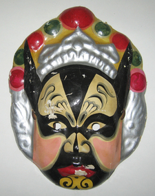
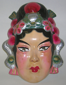
costume mask, Young Chinese League costume male mask
This mask was obtained by Charles Quon, probably from Hong Kong, and used by the Young Chinese League in their processions.This mask is significant for its links to the Chinese Young League. The League was formally established on 4 October 1932 to to promote free social intercourse and goodwill among its members and their mutual improvement. Membership was open to all persons, with one or both parents or grandparents born in China. Wives of Chinese members were permitted as members with the same privileges. It was a significant social organisation for Chinese-Australians in Melbourne in the mid to late twentieth century.A costume mask of a male character. He has a silver headdress with pink, green and yellow decorations. He has black horns, a black face with pink cheeks, red lips and markings on his forehead, nose and chin. The eyes has been cut out for the wearer to see out of. There is a strap that runs behinds the mask.young chinese league, melbourne, victoria, australia, processions, masks -
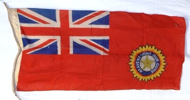 8th/13th Victorian Mounted Rifles Regimental Collection
Flag - Indian flag, 1945 circa
The emblem and motto is that of the Most Exalted Order of the Star of India established by Queen Victoria in 1861 shortly after the Indian Mutiny to honour Indian princes and chiefs, presumably those who had remained loyal to the crown, and British officers and administrators. The use of English in the motto perhaps indicated English was the language of the British Empire superseding the Roman Empire with its Latin. The wording is sufficiently vague to include other faiths to which many Indian princes belonged. This flag was probably brought home as a souvenir at the end of WWII (1939-1945) Rare example of the flag of an allied nation in World War 2 (1939-1945).Red ensign with Union flag canton and emblem in centre of fly. The emblem is a five pointed star surrounded by a motto “Heavens Light Our Guide” and set in a sunburst. Prior to 1947, it was the flag of British India at international events. It was superseded by the current Indian tricolour when India became independent. Rope runs through the hoist.flag, star of india -
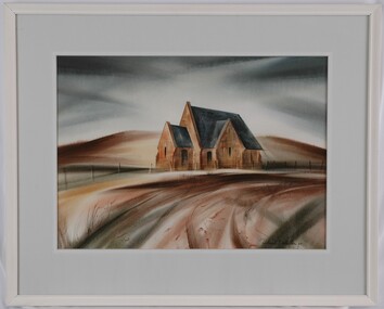 Glenelg Shire Council Cultural Collection
Painting, Robert Miller et al, Old Church Portland, 1965
CEMA Art CollectionThe painting depicts a church in an otherwise empty landscape. Within the foreground is a sweeping corner of a dirt road. Along the edge of the road runs a simple fence. Behind the church is a bare yellow and brown hill which reaches into a dark sky. The work has a wooden, white painted frame with grey mount and white trimming and glass.Front: Robert T. Miller 75 (lower right, black signature) Back: ROBERT MILLER " OLD CHURCH PORTLAND" (1966) (lower right, typed) Watercolourportland, church, streetscape, religion -
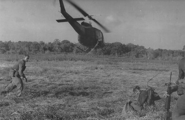 National Vietnam Veterans Museum (NVVM)
Photograph, Gibbons, Denis, Dustoff
Denis Gibbons (1937 – 2011) Trained with the Australian Army, before travelling to Vietnam in January 1966, Denis stayed with the 1st Australian Task Force in Nui Dat working as a photographer. For almost five years Gibbons toured with nine Australian infantry battalions, posting compelling war images from within many combat zones before being flown out in late November 1970 after sustaining injuries. The images held within the National Vietnam Veterans Museum make up the Gibbons Collection. A black and white photograph Diggers from 11 Platoon D Company 6 RAR on Operation Portsea, South East of the Australian Task Force Base at Nui Dat, as the Dustoff helicopter leaves with Pte Ken Mathieson, for casevac to hospital. Acting Officer Commanding Sgt Bob Buick runs back to his menphotograph, 11 platoon, 6 rar, operation portsea, dustoff, pte ken mathieson, sgt bob buick, gibbons collection catalogue, d company, nui dat, diggers, denis gibbons, 1st australian task force -
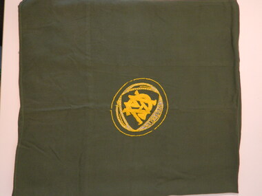 Kiewa Valley Historical Society
Tablecloth - CWA
The Country Women's Association of Victoria was a popular widely known organisation throughout Australia. The CWA aimed to improve health, welfare and education for women and children in the country.Each town / area in the Kiewa Valley had an active CWA. The Tawonga branch commenced in Feb. 1946 and often combined activities with other branches in the Kiewa Valley. One of their activities may have been to play cards.Green cotton square tablecloth for a fold-up card table. It has an yellow with a little bit of white embroidered circle / emblem in one corner. Inside the circle is "Victoria' and CWA (on top of each other as per the CWA emblem.) The edges are hemmed and a seam runs around all edges so that the square sits correctly on the table.Victoria CWAcountry women's association, tablecloth, community, volunteers, women, charity -
 Deaf Children Australia
Hearing Aid, Widex P/L, Widex Hearing aid, 1950s
The first all transistor hearing aids appeared in 1953. They were created to replace vacuum tubes; they were small, required less battery power and had less distortion and heat than their predecessor. The vacuum tubes were typically hot and fragile, so the transistor was the ideal replacement. The size of these transistors led to developments in miniature, carbon microphones. These microphones could be mounted on various items. There were body hearing aids where the earpiece was connected to the hearing aid and battery pack worn on the body. Ear level hearing aids consisted of eyeglass, behind the ear (BTE), in the ear (ITE), and in the canal (ITC, CIC) hearing aids. A Widex 25 hearing aid from the 1950's made in Denmark. Brown and gold metallic casing with a volume control dial and an on/off switch. The curly wire runs to a circular outer disc. Although not present the disc would normally connect to an ear mould which is individually fitted to the wearer. The item comes in a soft leather case."DENMARK" inscribed on gold front. "WIDEX 25" inscribed on back. "WIDEX" on inside cover of case. "W" on outside cover of case device, hearing aid, loss, hard of hearing, deaf children australia, victorian school for deaf children, vsdc, denmark, widex -
 Chinese Museum
Costume - costume mask, Young Chinese League costume female mask
This mask was obtained by Charles Quon, probably from Hong Kong, and used by the Young Chinese League in their processions.This mask is significant for its links to the Chinese Young League. The League was formally established on 4 October 1932 to to promote free social intercourse and goodwill among its members and their mutual improvement. Membership was open to all persons, with one or both parents or grandparents born in China. Wives of Chinese members were permitted as members with the same privileges. It was a significant social organisation for Chinese-Australians in Melbourne in the mid to late twentieth century.A costume mask of a female character. She has a headdress of pink flowers, green and silver decorations. She also has a high bun. She has painted eye brows, eye liner, rosy cheeks and lips that are painted red. The eyes has been cut out for the wearer to see out of. There is a strap that runs behinds the mask.young chinese league, costume, mask, melbourne -
 Beechworth RSL Sub-Branch
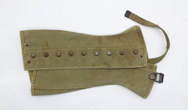
Legging, c. 1938
Khaki coloured canvas legging constructed of three panels, sewn together with beige topstitching. Gaiters fasten around leg by way of nine hooks which fit into metal eyelets; a strip of canvas runs under the foot and is buckled on the other side. One tag on interior and printed manufacturer's information on interior centre panel; printed in black.Tag reads "2-R"; printed inscription reads "2R/LEGGINGS,CANVAS, M-1938 DISMOUNTED O.D./THE BRAY COMPANY/10-27-43 W 12-036 OM 114B/72-L-61923/JEFFERSONVILLE OM DEPOT"second world war, uniform, jeffersonville -
 Bendigo Military Museum
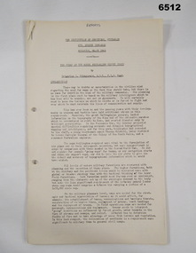
Administrative record - The story of the Royal Australian Survey Corps - Brigadier L Fitzgerald OBE, FIS 1962, Brigadier L Fitzgerald OBE, FIS Aust, Canberra, March 1962
This is a report prepared by the Director of the Royal Australian Survey Corps Brigadier L Fitzgerald OBE, FIS Aust for presentation at the Institution of Surveyors, Australia, 6th Survey Conference held in Adelaide in March 1962. This document mentions the beginning of mapping in 1907 in the Australian Intelligence Corps and how the Survey Corps was formed in 1915. The story continues until 1962. A full copy of the report is attached as a video in .mp4 format.14 x page typed foolscap size paper report, stapled and 4 x hole punched. Each page has been photographed at 200dpi and saved in .jpg format. The complete set of these .jpg pages have then been combined into a video in ,mp4 format. The Video is 1.34Mb in size and runs for 2:48 min 48.Some handwritten notes next to some paragraphs by an unknown author.royal australian survey corps, rasvy, fortuna, army survey regiment, army svy regt, asr -
 Melbourne Tram Museum
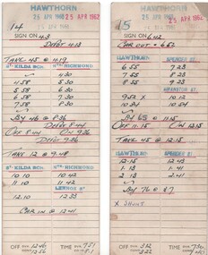
Administrative Record - Table Cards, Melbourne & Metropolitan Tramways Board (MMTB), Anzac Day, Apr. 1960
Hand written table card for Hawthorn depot written on a pre printed cardboard sheet giving details for runs 14 and 15 (Anzac Day - for 1960, 1961 and 1962). Gives sign on times, car out, trip details and which "run" takes the tram from the crew. Destinations and dates have used hand stamps.trams, tramways, table cards, hawthorn depot, drivers, anzac -
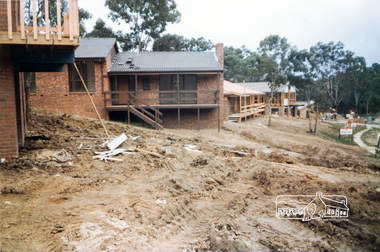 Eltham District Historical Society Inc
Photograph, Building development, 1985, 1985
Viewing from left Nos. 3, 5, 7 and 9 Long Valley Way, Eltham. Fiona Court runs off between 7 and 9. Shire of Eltham Archives Series 13, Photograph Album, 1985. Originally contained in a 2-ring PVC binder and document sleevesColour photographseries 13, shire of eltham archives, construction, eltham, long valley way, houses -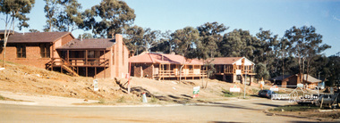
 Ballarat Tramway Museum
Document - Table Cards (Sheets), State Electricity Commission of Victoria (SECV), Sebastopol - Lydiard St. Nth, Aug. 1971
Set of 6 sheets, photocopied on heat sensitive paper, foolscap size graph paper sheets giving the weekday tables or runs for the SEC Ballarat trams on the Sebastopol - Lydiard St. Nth service following the closure of the Victoria St. - Gardens via Drummond St Nth and Mt Pleasant - Gardens via Sturt St. West services. Gives details of 18 tables or runs, numbered from 12 Run to 38 Run. Each sheet headed "Weekdays". Each run details where the driver/conductor would sign on, time, the trips, meal breaks, finish time and the total time of the shift. Stored with these sheets are a photocopies of each sheet reduced to A4 size and full size copies made on A3 paper, trimmed to size.trams, tramways, timetables, sec, ballarat, crews -
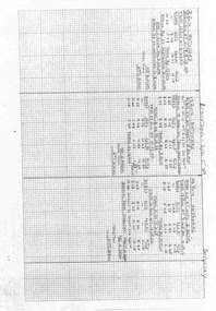 Ballarat Tramway Museum
Document - Table Cards (Sheets), State Electricity Commission of Victoria (SECV), SEC Ballarat trams on the Sebastopol - Lydiard St. Nth, Aug. 1971
Set of 5 sheets, photocopied on heat sensitive paper, demi-quarto (double quarto) size graph paper sheets giving the Saturday tables or runs for the SEC Ballarat trams on the Sebastopol - Lydiard St. Nth service following the closure of the Victoria St. - Gardens via Drummond St Nth and Mt Pleasant - Gardens via Sturt St. West services. Gives details of 14 tables or runs, numbered from 2 Run to 33 Run. Each sheet headed "Saturday". Each run details where the driver/conductor would sign on, time, the trips, meal breaks, finish time and the total time of the shift. Stored with these sheets are a photocopies of each sheet reduced to A4 size and full size copies made on A3 paper.trams, tramways, timetables, sec, ballarat, crews -
 Eltham District Historical Society Inc
Negative - Photograph, J.A. McDonald, Newly built home, Sep. 1955
Street and location unidentified, possibly not Eltham though next immediate frame is Pryor Street and sun position appears to be similar indicating street (ealrly to mid afternoon) indicating street runs east west direction and camera view is to the south. Streets in Eltham are all even numbered on the south sideRecord of various Shire of Eltham infrastructure works undertaken during the period of 1952-1962 involving bridge and road reconstruction projects, sometimes with Eltham Shire Council Project Reference numbers quoted. It was during this period that a number of significant improvements were made to roads and new bridges constructed within the shire that remain in place as of present day (2022). In many situations, the photos provide a tangible visible record of infrastructure that existed throughout the early days of the Shire. The album was put together by or under the direction of the Shire Engineer, J.A. McDonald.1955-09, houses, shire of eltham -
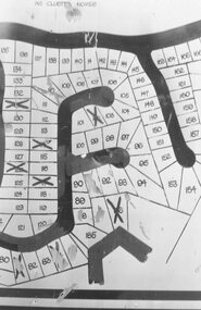 Ringwood and District Historical Society
Photograph, Plan of Lots in Bel-Air Estate 1991
4 photographs of sections of the plans.a. Written on back of photograph, "20/6/81. Plan of Bel Air Estate. Werac Drive runs down left side of plan. Kubis Drive crosses top. Debbie Place drops down from Kubis. Manuela Tce. runs right from Werac, ends at a bend and becomes Rudolf Court running North. Lyn Court takes off right from Rudolf and Burlock Ave. touches estate with an elbow" b. Written on back of photograph, "20/6/81. Plan of lots in Bel Air Estate. Glenvale Road down left side of plan, Kubis Dr. Runs across picture. June Square drops from and Jenken Close rises form Kubis Dr. Werac Dr. drops to bottom of picture and Manuella takes off to right". d. Written on back of photograph, "20/6/91. Lots in Bel-Air Estate. Kubis Dr. rises from bottom left to Oban Road top. Pamela Crt. drops from Kubis at left, Iluka Crt. takes off right. Whitlam Dr. runs left at top and Menzies Cr. drops off it to centre of picture". c. Written on back of photograph, "20/6/81. Plan of lots on Bel-Air Estate. Kubis Dr., Debbie Place, Pamela Crt, Iluka Crt. Menzies Drive" -
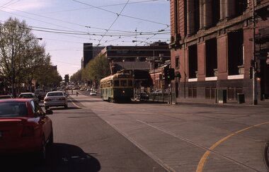 Melbourne Tram Museum
slide - Colour - W6 983 Spencer and Bourke Streets, David Verrier, 20-9-2002
Photos show W6 983 (Route 12 - South Melbourne St Kilda Beach) at the intersection with Bourke St. Tram has been diverted to run via La Trobe St, normally runs via Collins St. Has the Mail Exchange and The Age buildings in the background, 20-9-2002Yields information about a diverted tram during 2002.Set of two colour Sides - white Kodak KodachromeSlide marked with date and details.tramways, tram 983, w6 class, spencer st, mail exchange, route 12, diversion