Showing 13655 items
matching stations
-
 Surrey Hills Historical Society Collection
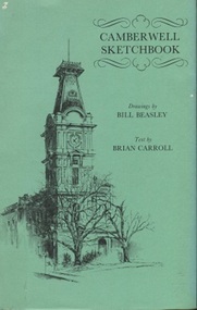
Book, Camberwell Sketchbook, 1978
History of Camberwell, including origin of name, history of Canterbury; Camberwell and Canterbury shops, Fairholme, Camberwell Station, Hartwell Station, Camberwell Tram Depot, Frognall, Camberwell Grammar, Fintona.History of Camberwell, including origin of name, history of Canterbury; Camberwell and Canterbury shops, Fairholme, Camberwell Station, Hartwell Station, Camberwell Tram Depot, Frognall, Camberwell Grammar, Fintona. |56p|ill.camberwell, historic buildings, maranoa gardens, st. barnabas church, shrublands, fintona, frognall, fairholme -
 Victoria Police Museum
Police Stations (Altona)
Altona is a suburb of Melbourne, 13 km south-west of Melbourne's CBD and located within the City of Hobsons Bay Altona Police Station opened as a temporary police station in 1919 in the Melbourne District. It was on the corner Sargood and Blyth Streets. It was staffed by one 1st Constable. The original police station was in a small room attached to the front of a 5-roomed weather-board dwelling with an iron roof on land measuring 66' x 165'. There was also a kitchen, vestibule, wash-house, office, one W.C. and a lock-up. In 1929 it became part of the Bourke District. On 31 March 1958 it moved into newly built government premises at 51-53 Blyth Street, on the corner of Bent Street. The building consisted of a cream brick veneer police residence and police station with cell. Staff was increased to a Sergeant in Charge and 3 Constables. A new police station was opened in Altona North on 7th October 1979. The Altona Police Station remained as a sub-station for a few a short time until the building was sold. July 2019 - a new police station is being constructed at 1 Galvin Street, Altona. Galvin Street was names after S/C Michael Arthur Galvin, 3651, who was appointed on 5 Jan 1886 and resigned on 4 Dec 1913. He was Werribee Shire President 1926-1927 and 1940-1941 8 black and white photos of new police station, 1963police stations; altona police station -
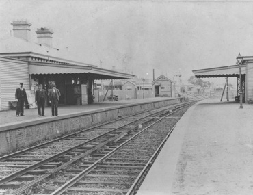
 Sunshine and District Historical Society Incorporated
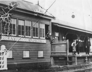
Photograph (1905), BRAYBROOK JUNCTION STATION
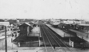
The Braybrook Junction railway station was opened on 7th September 1885 at the junction of the railway lines to Ballarat and to Bendigo. In 1904 H. V. McKay purchased the Braybrook Implement Works nearby, and in 1906 he moved his Sunshine Harvester Works agricultural machinery business from Ballarat to Braybrook Junction. In 1907 the station and township were renamed Sunshine after the Sunshine Harvester Works. On 20 April 1908 (Easter Monday), Sunshine station was the scene of the biggest train disaster in Victoria, when 44 people were killed and 400 injured from the 1100 people that were aboard the two trains. A Melbourne bound train from Bendigo collided with the rear of a train from Ballarat. There is a memorial plaque on platform 1 at the present Sunshine station. Sunshine station has recently been undergoing a complete rebuild. On 20 January 2014 the station, although not yet completed, was opened for train use, after being closed for several weeks.This photograph is significant because it is a reminder that the present Sunshine station and the nearby area were once named Braybrook Junction. It also shows what the Station, the Signal Box, and the station personnel looked like in circa 1905.Monochrome photograph showing Braybrook Junction Station and the Signal Box, plus station personnel. One of the personnel is holding a 'Staff' which was actually the authority for the train to proceed to the next Station or Signal Box. Photograph has substantial crazing in the upper left corner, a long diagonal crease, and dog eared corners.BRAYBROOK JUNCTNbraybrook junction station, railway, sunshine, train, transport, 1905, 1907, 1908, 7 september 1885 -
 Puffing Billy Railway
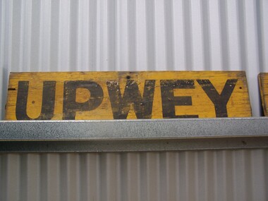
Station Sign - Upwey
Upwey Station Sign; Upwey Railway Station is located on the Belgrave line in Victoria, Australia. This railway serves the Eastern region of Melbourne. Upwey Railway Station opened on the 3rd of June 1901. Upwey Railway Station has a crossing loop in the middle of a six kilometre section of single railway track between Ferntree Gully Railway Station and Belgrave Railway Station. The station was originally on the Upper Ferntree Gully to Gembrook narrow gauge line. The Upper Ferntree Gully to Gembrook Narrow Gauge railway line officially closed on the 30th of April 1954. It saw further use between 1955 and early 1958, when trains were operated by the Puffing Billy Preservation Society in co-operation with the Victorian Railways. The Upper Ferntree Gully to Belgrave section was converted to Broad Guage and re-opened on the 19th of February 1962. This station sign shown here was one of a number used on the Upwey Railway Station while it was Narrow Gauge. Historic - Victorian Railways Station sign used at Upwey StationUpwey wooden rectangle Station name sign pained yellow background with black font.Upweypuffing billy, station sign, upwey station, victorian railways -
 Whitehorse Historical Society Inc.
Document, McGlone's Estate Mitcham, 1/04/1921 12:00:00 AM
Copy of pamphlet of McGlone's Estate, Mitcham auctioned April 1921.Copy of pamphlet of McGlone's Estate, Mitcham auctioned April 1921. 24 allotments. Bordered by Whitehorse Road, McGlone Street, Station Street and Mitcham railway line and station. Original in Haughton maps, LaTrobe Library.Copy of pamphlet of McGlone's Estate, Mitcham auctioned April 1921. land sales, auctions, mcglone, john, mcglone, elizabeth, whitehorse road, mitcham, mcglone street, mitcham, station street, mitcham, mitcham railway station, haughton map collection, state library of victoria. latrobe library -
 Melbourne Tram Museum
Photograph - Black and White photograph, Bob Lilburn, mid 1950's?
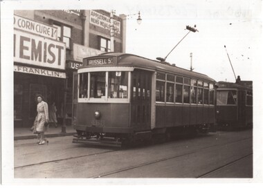
Black and white photograph of X1 460 (Russell St) at the Footscray Railway station with an X2 class car behind. Note the metal pan in the overhead to assist to set the trolley pole at night. In the background is a chemist? Franklin advertising a Corn Cure 1/- and Appleton & Wright Men's Wear Store. Photo possibly mid 1950's and by Bob Lilburn.On rear in ink "460 at Footscray Rly Station"trams, tramways, x1 class, footscray, russell st, overhead, tram 460, leeds st, x2 class, mmtb -
 Rutherglen Historical Society
Image, Norman W. De Pomeroy, 1/07/1960
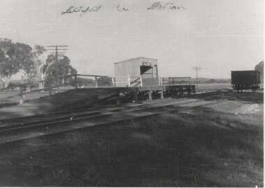
Black and white photograph of the Lilliput siding platform and stationWritten at top of photo: "Lilliput Railway Station: On back of photo: "Lilliput Siding - A solitary truck awaits loading. 1.7.1960" "Located at Map Ref 526 032" Rubber stamp: "Photographed by Norman W. De Pomeroy"railway stations, lilliput -
Clunes Museum
Painting, Jon Crawley, Evening Shadows
WATERCOLOUR OF CLUNES RAILWAY STATION GILT FRAMED WATERCOLOUR OF CLUNES RAILWAY STATION TITLED "EVENING SHADOWS"SIGNED BY JOHN CRAWLEY 1989artist, clunes railway station, john crawley -
 Port Melbourne Historical & Preservation Society
Memorabilia - Matchbox, Fred Cook's Station Hotel, c.1990
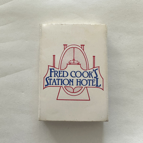
The Station Hotel was converted into three townhouses in 1995.The small white matchbox from the Station Hotel situated on the corner of Bridge & Station Streets, Port Melbourne. It was owned by well-known Port Melbourne footballer, Fred Cook from 1982. The background of the front cover logo depicts a stylised football with the four goalposts and 'Fred Cook's Station Hotel' in dark blue. The original Station Hotel was built in 1872 and a second story was added at a later date. The back cover lists the hotel's attractions as Bistro & Piano Bar, A La Carte Menu, Cocktail Bar, Friendly Atmosphere and excellent service as well as the address, 116 Station Street.fred cook, station hotel, built environment - commercial, port melbourne football club, business and traders - hotels -
 City of Kingston
Photograph - Digital image, Black and white, c. 1910
Black and white image of Chelsea Railway Station showing the impact of the railways on the development of the area. Shops and shoppers can be seen behind the station buildings.The extension of the railway line from Mordialloc to Frankston influenced the development of the villages along the train line. Shops and community buildings were built in proximity to the station, along with the subdivision of land for houses. Black and white image of Chelsea Railway Station showing platforms and local shopschelsea, railway station, railway, shopping strip, public transport -
Port Melbourne Historical & Preservation Society
Photograph - Interior of Pumping Station, Esplanade West, Port Melbourne, John KIRBY, 11 Nov 2014
Photos of interior of the Esplanade West Pumping station taken by donor with permission of Melbourne Water.Digital images of the interior of the Esplanade West Pumping Station.pumping station, esplanade west, melbourne water, utilities -
 Stawell Historical Society Inc
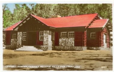
Postcard, Comfort Station Camping Reserve at Halls Gap in the Grampians -- Postcard
Comfort Station Camping Reserve No 33 Halls Gap The GrampiansLog cabin with a tin roof and stone features around entrance and windows. Building in natural setting.Comfort Station, Camping Reserve hall's Gap Grampians No 33.halls gap grampians -
 Marysville & District Historical Society
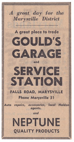
Ephemera (Item) - Newspaper advertisement, Unknown
A newspaper advertisement for Gould's Garage and Service Station in Marysville in Victoria.A newspaper advertisement for Gould's Garage and Service Station in Marysville in Victoria. This garage was owned and operated by the Gould Family in Marysville. The garage was also an agent for Holden.gould family, gould's garage, gould's service station, marysville, victoria, holden -
 Marysville & District Historical Society
Photograph (item) - Colour photograph, Pre 2009
A colour photograph of the pumping station at Steavenson Falls in Marysville in VictoriaA colour photograph of the pumping station which is situated at Steavenson Falls in Marysville in Victoria. The pumping station provides power to the floodlights which then lillumniate the falls every night between sundown and 11.00pm. The Steavenson Falls is named after the Victoria Assistant Commissioner of Roads and Bridges, John Steavenson who arrived in Victoria in the early 1860's.pumping station, steavenson falls, marysville, victoria, flood lights, john steavenson -
 National Wool Museum
Newspaper, Stock and Station Journal
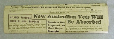
Newspaper, "Stock and Station Journal", Monday 27th August 1951.Newspaper, "Stock and Station Journal", Monday 27th August 1951.agriculture - news, geelong and western district stock and station journal, woods, mr george -
 Numurkah & District Historical Society
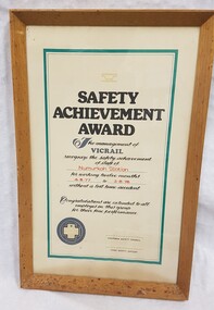
Certificate - Safety Certificate - Numurkah Railway Station
Part of a railway collection from the closed Numurkah Railway StationWooden framed certificate to Numurkah Railway Station / Glass coveredas per photo -
 Yendon History Group
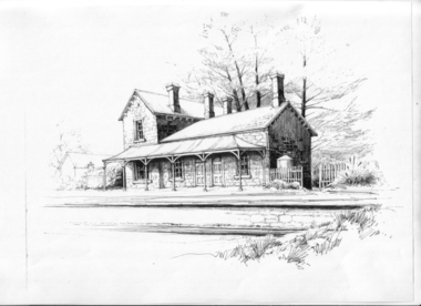
Ink drawing, Jenny John, 6:MMMM, 2010 (exact)
A pen and ink drawing by Jenny John of the Yendon Railway Station composed from photographs taken of five other stations of the same or similar design. Used as the picture on the interpretive sign installed at the station site, Harbours Road Yendon, in 2011.Pen and ink drawing of the Yendon Railway Station by artist Jenny John A3 in size.Signed by Jenny John at bottom right hand sideink drawing, yendon railway station, john jenny -
Whitehorse Historical Society Inc.
Article, Station on track, 2014
Mitcham and Rooks Road railway line crossings are being lowered to eliminate gates, and a new station for Mitcham, with 800 parking places, is being built.Mitcham and Rooks Road railway line crossings are being lowered to eliminate gates, and a new station for Mitcham, with 800 parking places, is being built. The roads and station will be opened on 25 January 2014.Mitcham and Rooks Road railway line crossings are being lowered to eliminate gates, and a new station for Mitcham, with 800 parking places, is being built. mitcham railway station, mitcham railway crossing -
 Ringwood and District Historical Society
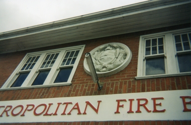
Photograph, Ringwood Fire Station at 255 Maroondah Highway circa 1998, Feb-98
This fire station was closed and a new one opened on Maroondah Highway on the site of the old miner's cottage near the corner of the Highway and Mt Dandenong Road.Five coloured photographs of the Ringwood fire station at 255 Maroondah Highway and of the fireman's house when it was sold. It later became 'The Fire Station Restaurant.' -
 Ringwood and District Historical Society
Photographs, Ringwood Fire Station at 255 Maroondah Highway circa 1998
This fire station was closed and a new one opened on Maroondah Highway on the site of the old miner's cottage near the corner of the Highway and Mt Dandenong Road.Five coloured photographs of the Ringwood fire station at 255 Maroondah Highway and of the fireman's house when it was sold. It later became 'The Fire Station Restaurant.' -
 Greensborough Historical Society
Photograph - CD-ROM, Geoff Tulloch, Greensborough Police Station Images, 2013
Digital phones of Greensborough Police Station at various stages throughout the yearsCD containing photos of Greensborough Police Station at various stagesgreensborough police, geoff tulloch -
 Surrey Hills Historical Society Collection
Digital photo, Surrey Hills Railway Station
Surrey Hills Railway Station before electrifation cir. ? looking towards Melbourne city. No people are identified.Surrey Hills Railway Station with railway staff and others. -
 Kiewa Valley Historical Society
Photographs – SECV – Clover Power Station
The Junction Dam and Clover Dam Power Station, stages of the Kiewa Hydro-Electric Scheme, were needed to meet the increased power demands of the wartime industry in Victoria. Clover added 26 megawatts to the grid. Junction Dam was completed and ready to hold water by September 1943, but was emptied in December 1943 and not filled again until May 1944. Construction of Clover Power Station commenced in July 1941 and both turbines were in service by May 1945Clover Power Station and Junction Dam were part of the Kiewa Hydro Electric Scheme constructed by the State Electricity Commission of VictoriaSet of 21 black and white photographs taken by the official SECV photographer who gave each photo a number prefixed by K (for Kiewa) K1463- 22 Mar 1944 Inside Clover Power Station K1464- 23 Mar 1944 Valve K1466- 23 Mar 1944 Fittings for the power station K1467- 23 Mar 1944 Valve K1472- 30 Mar 1944 Equipment being installed in Clover Power Station K1474- 31 Mar 1944 Equipment for the power station K1493- 19 April 1944 Transformer K1495- 28 April 1944 Part of the generator being installed K1514- 11 May 1944 Equipment in the power station K1563- 9 June 1944 Turbine under construction K1565- 22 June 1944 Shaft between turbine and generator K1567- 22 June 1944 Turbine in the power station K1568- 22 June 1944 Transformers K1570- 5 June 1944 Guide vane actuators K1574- 22 June 1944 Equipment in the power station K1567- 22 June 1944 Clover Power Station K1607- 14 Aug 1944 Equipment in the power station K1620- 27 Aug 1944 ‘Charles Tavare (?) Equipment in the power station K1626- 23 Aug 1944 Clover Power Station K1628- 23 Aug 1944 Clover Power Station K1629- 23 Aug 1944 Clover Power Station On the back- each photograph has a handwritten reference number starting with K and the date stamped or writtensecv; kiewa hydro electric scheme; clover power station; junction dam; bogong -
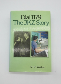 Hume City Civic Collection
Book, Dial 1179/The 3KZ Story
This book is a history of Radio Station 3KZ and its substantial role in broadcasting in Australia.A hardback cover of the history of Radio Station 3KZ with loose cover."Dial 1179/The 3KZ Story..."radio, 1980s, george evans collection -
Glenelg Shire Council Cultural Collection
Administrative record - Supplementary Police Report of Criminal Offence - Larceny 1912, 06/12/1912
Casterton Police Station reports.Handwritten supplementary Police Report of Criminal Offence - Larceny, Casterton Police Station.Back: report continues on reverse -
 Puffing Billy Railway
Ballarat Station Parcels Office Clock
This historic railway clock , originally installed in the Parcels Office at Ballarat Station Station Clock - Ballarat Station A Victorian Railways Station clock that was located in the Parcels Office at Ballarat. In the 19th Century, time was not seen as an urgent requirement to be somewhere or do something. There was sun up and sun down. A number of towns in Victoria operated on different times to other towns in the state. With the coming of the railways in Victoria from 1854, time became more important not only from the public side, but from a railway operational safety side. Clocks started appearing at railway stations, sometimes showing a different (standard) time to that of the local town. Eventually all of Victoria was bought into the same time zone, which matched the railway standard. Historic - Station Clock - Ballarat Station - which was used in the Parcels Office at the Victorian Railways Ballarat railway stationStation Clock - Ballarat Station Parcels Office Clock Antique timber cased railway clock. Circular face with Roman numerals. By Foster of London, with numbered brass plaque '631'. Single barrel fusee movement. Foster London 631 puffing billy, ballarat station, station clock -
 City of Moorabbin Historical Society (Operating the Box Cottage Museum)
Photograph, Black & White Postcard, Cheltenham Railway Station c1920, c1920
Although the Railway line had been planned for some time Sir Thomas Bent MP was responsible for making it happen in order to revitalize the fortunes of the Moorabbin Shire that he had represented for so long. The train line opened in 1881with 8 Stations between Caulfield and Mordialloc.The first Steam engine carried dignitaries and local residents. Bent also ensured that the Station houses in his constituency were built in a distinctive decorative cottage style. Bent faced severe criticism for diverting the rail line through his local area and for the expenditure on the Stations. Local residents established and cared for Gardens at the Stations and Cheltenham was awarded Best Garden c1910. The arrival of the Railway Line saw the traders move from Point Nepean Rd to Charman Rd and by 1910 various shops and business were present. 2016 - current has seen large protest rallies against the destruction of Mentone Station and Cheltenham Station as the Victorian State Government proceeds to remove Railway Level Crossings. A compromise to retain the Station buildings whilst placing the Rail Line underground is desired.Cheltenham Railway Station is one of the original cottage style stations ordered by Sir Thomas Bent when the rail line was extended from Caulfield to Mordialloc 1881Photograph Black & White Postcard showing the entrance to Cheltenham Railway Station c1920Valentine &Sons Pub Co Ltd Melb railways, cheltenham station, mentone station, south brighton station, railway level crossing removal 2016 -19, smith j l; smith mary ann, stanley helen, smith vic, smith harry redvers, chaff cutter, horse drawn carts, toll gates brighton, motor cars 1900, steam engines, early settlers, bentleigh, parish of moorabbin, city of moorabbin, county of bourke, moorabbin roads board, shire of moorabbin, henry dendy's special survey 1841, were j.b.; bent thomas, o'shannassy john, king richard, charman s, highett william, ormond francis, maynard dennis, market gardeners, vineyards, orchards -
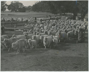 National Wool Museum
Photograph - Sheep at Boonoke Station, 1960s
One of fifty one photographs originally in a photo album found in the National Wool Museum’s office. The album was water damaged and the images were removed for conservation. The images follow the process of wool. Beginning in a sheep paddock and finishing as a folded fabric. It includes all the steps in between in this process, including shearing, transporting, selling, washing and the many different steps in the process of turning a single thread of wool into fabric.Black and white image showing sheep coming in to shearing shed yards at Boonoke Station.AUSTRALIAN NATIONAL PUBLICITY / ASSOCIATION / FLINDERS STREET RAILWAY BUILDING, / MELBOURNE AUSTRALIA / W57 / W57. Sheep being driven from pasture to yards at shearing shed, / Boonoke Station.wool industry, working life, women, boonoke station, farming, sheep farming, agriculture, sheep stations, transport, wool processing, shearing, textile industry, wool -
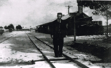 Otway Districts Historical Society
Photograph, Beech Forest Railway Station: Laurie McCabe in charge, 1920s
Laurie McCabe was in charge of Beech Forest Station until October 1929. When the timber industry went into decline because of poor markets and the crippling effects of the 1929 strike, and when road haulage signalled the beginning of a new transport era it was the beginning of the end. As a result staffing levels were severely cut over the period 1927/29 with the two station masters at Beech Forest and Gellibrand replaced by caretakers in October 1929. The line was then supervised by travelling station masters of whom Laurie McCabe was one of two.B/W. Laurie McCabe in charge of Beech Forest Railway Station in the 1920s, pictured on track one just down from the station buildings. Note the slight snow covering on the tracks.beech forest; railways; laurie mccabe; -
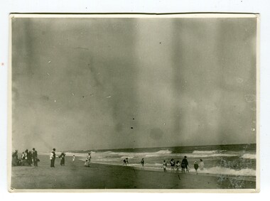 Orbost & District Historical Society
black and white photograph, January 1901
This photograph was taken at the "old station" at Corringle near Orbost. It was a popular picnic spot. Late in 1857 Mr Thomas T. Stirling took over Corringle Run ("Corringle" means "shallow water"). Mr Stirling and his family came from the wester district - Winchelsea. He settled at the Old Station. A few people were employed at the Orbost Stationb and there was settlement on the Orbost flats, Mr T. T. Stirling held the land from Lake Tyrers to Bemm River as a cattle run. About 1888 he became Secretary of the new Tambo Shire.This is a contemporary pictorial record of rural family life in Orbost in the early 20th century.A black / white photograph showing people on a beach with some in the water. those on the sand are dressed formally - men wearing suits and hats, the ladies in long dresses and hats.on back - "Picnic at OLD STATION Jan 1901"orbost-station orbost-family-life recreation