Showing 770 items
matching the white farm
-
 Greensborough Historical Society
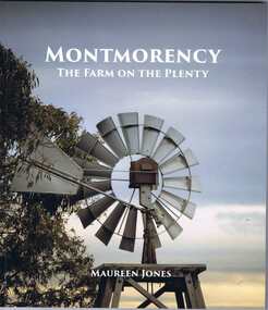
Book, Montmorency: the Farm on the Plenty / by Maureen Jones, 2015_
A history of the Melbourne suburb of Montmorency from its time as a hunting ground for the Wurundjeri willam people to its uptake by white settlers and eventual evolution to the suburb we know today.A well researched and documented history of the Montmorency area.166 p., illus. (some col.). Soft cover.maureen jones, montmorency -
 Greensborough Historical Society
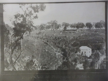
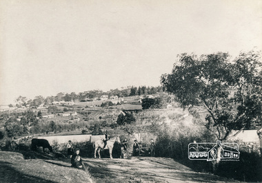
Photograph (copy), Fred Kruger, On the Plenty River near Bundoora / photograph by Fred Kruger, 1877c
View of farm land and mill on the Plenty River near Bundoora, circa 1877; photograph by Fred Kruger. Original held at SLV (accession # H473 and Image # a53840)Black and white photograph, enlarged and laminated.fred kruger, plenty river -
 Greensborough Historical Society
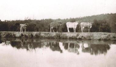
Photograph - Digital image, Cows on Hill Dam at Apollo Parkways, 1935c
Dam on the Partington property at what is now Apollo Parkways Greensborough.The Partington family came to Melbourne in the 1840s and moved to Greensborough where they farmed along the Plenty River. Descendants still live in Greensborough.Digital copy of black and white photograph.partington family -
 Greensborough Historical Society
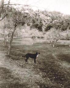
Photograph - Digital image, Old orchard at Partington Flat, 1930c
Remnants of the Partington orchard at Greensborough on land that is now the Partingtons Flat reserve in Greensborough. Charles Partington and family came to Melbourne in the 1840s and moved to Greensborough where they farmed along the Plenty River. This dog belonged to Jessie Partington.Digital copy of black and white photograph.partingtons flat, partington family -
 Greensborough Historical Society
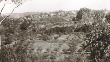
Photograph - Digital Image, Partingtons Flat and Whatmough Park taken from hill, 1930c
The Partington and Whatmough families came to Melbourne in the 1840s and moved to Greensborough where they farmed along the Plenty River. The Partingtons Flat Reserve and Whatmough Park were part of their land holdings and are now Banyule Council owned reserves and sporting fields.Digital copy of black and white photograph.partington family, whatmough family, whatmough park, partingtons flat -
 Greensborough Historical Society
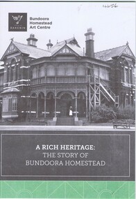
Pamphlet, City of Darebin, A Rich heritage: the story of Bundoora Homestead, 2016_
History of Bundoora Homestead, from its initial use by John Matthew Vincent Smith as a horse and cattle stud, and later as a convalescent farm and repatriation hospital until its ownership by Darebin City Council and restoration.10 p. pamphlet, col. & black & white photographs and plansbundoora homestead -
 Greensborough Historical Society
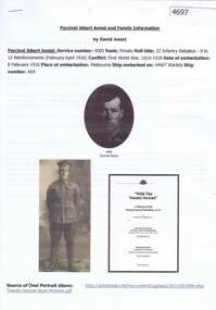
Document, David Amiet et al, Percival Albert Amiet and family information, by David Amiet, 1881o
Information supplied by Richard Gary Amiet to David Amiet, who compiled this document. Includes Percival Albert Amiet's war service in 1916. His son Claude by his first marriage was brought up by his sister Ethel at a dairy farm in Greensborough.5 pages, black and white print, black and white and colour photographs.amiet family, percival albert amiet -
![Document, Graeme Butler & Associates et al, Bell's Cottage [Happy Hollow]: Victorian Heritage database report, 26/02/2017](/media/collectors/4f729f5697f83e03086015b8/items/59cc514221ea7a0f3c6ce8a6/item-media/59eeff6521ea67113c5b327b/item-fit-380x285.jpg) Greensborough Historical Society
Greensborough Historical SocietyDocument, Graeme Butler & Associates et al, Bell's Cottage [Happy Hollow]: Victorian Heritage database report, 26/02/2017
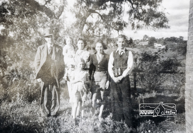
In 1997, Bell's Cottage at Happy Hollow Farm was included in the Nillumbik Heritage Overlay HO59.The cottage was built by Robert Whatmough and associated with the pioneering orchardists Frederick and Theodore Flintoff and William Verner. It is technically significant for its wattle and daub construction, vertical slabs and bark roof. It was destroyed by fire in 2003.3 p. typescript, one black & white photographhappy hollow farm, bell family -
 Greensborough Historical Society
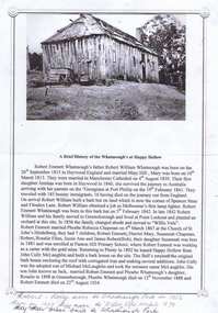
Article, A Brief history of the Whatmough's at Happy Hollow, 1960s
Information about Robert William Whatmough b. 1815 in Heywood, England and his son Robert Emmett Whatmough b. 1842 in Greensborough, d. 1924, who leased the site of Happy Hollow in 1892.1 p. typescript, 1 black and white photograph Notes on Whatmough family handwritten on bottom of page.whatmough family, happy hollow farm -
 Greensborough Historical Society
Photograph - Digital image, Jan Lewis, From Sondemeyer's looking towards swing bridge and Pope's farm, circa 1958, 1958c
From Sondemeyer's looking towards swing bridge and Pope's farm, circa 1958Digital copy of black and white photographsondemeyers hill, popes farm -
 Greensborough Historical Society
Hat, Medhurst Wines, Yarra Valley, 2016_
This hat was purchased at Medhurst Wines, Yarra Valley, as a gift for Faye Fort, who is a descendant of the Medhurst family. After leaving Greensborough, the Medhurst family moved to Gruyere in the Yarra Valley. They farmed the land that is now the vineyard that bears their name.Black polyester cotton sun hat with company logo in white stitchingLogo: "Medhurst Wines Yarra Valley"medhurst family, medhurst wines yarra valley -
 Greensborough Historical Society
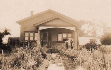
Photograph - Digital Image, Cherel Sartori, Kell's Cottage, 01/01/1956
Photograph of Kell's Cottage. The house was built 1917, at 112 Henry Street Greensborough by William Mitchell on the 60 acre dairy farm owned by Ethel and Walter Kell. This collection of photographs was copied by Cherel Sartori (who owned the house from 1990-2000), following a visit by Claude Amiet who lived in the house as a child in the early 20th century.Digital copy of black and white photographkell's cottage, claude amiet, cherel sartori -
 Greensborough Historical Society
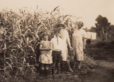
Photograph - Digital Image, Cherel Sartori, Claude Amiet at Kell's Cottage 1920s, 1920c
Photograph of Claude Amiet and others at Kell's Cottage in the 1920s. The house was built 1917, at 112 Henry Street Greensborough by William Mitchell on the 60 acre dairy farm owned by Ethel and Walter Kell. This collection of photographs was copied by Cherel Sartori (who owned the house from 1990-2000), following a visit by Claude Amiet who lived in the house as a child in the early 20th century.Digital copy of black and white photographkell's cottage, claude amiet, cherel sartori -
 Greensborough Historical Society
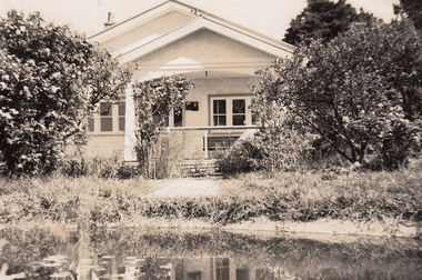
Photograph - Digital Image, Cherel Sartori, Kell's Cottage 1940s, 01/01/1956
Photograph of Kell's Cottage in the 1940s. The house was built 1917, at 112 Henry Street Greensborough by William Mitchell on the 60 acre dairy farm owned by Ethel and Walter Kell. This collection of photographs was copied by Cherel Sartori (who owned the house from 1990-2000), following a visit by Claude Amiet who lived in the house as a child in the early 20th century.Digital copy of black and white photographkell's cottage, claude amiet, cherel sartori -
 Greensborough Historical Society
Photograph - Digital Image, Cherel Sartori, Kell's Cottage, 01/01/1956
Photographs of Kell's Cottage in the 1940s. The house was built 1917, at 112 Henry Street Greensborough by William Mitchell on the 60 acre dairy farm owned by Ethel and Walter Kell. This collection of photographs was copied by Cherel Sartori (who owned the house from 1990-2000), following a visit by Claude Amiet who lived in the house as a child in the early 20th century.Digital copy of 3 black and white photographkell's cottage, claude amiet, cherel sartori -
 Greensborough Historical Society
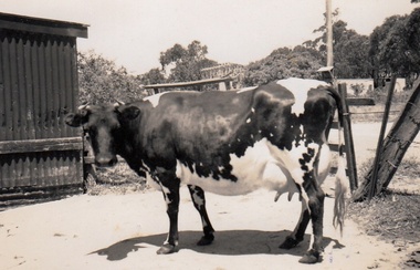
Photograph - Digital Image, Cherel Sartori, Cows at Kell's Cottage 1956, 01/01/1956
Photograph of a cow at Kell's Cottage in the 1940s. The house was built 1917, at 112 Henry Street Greensborough by William Mitchell on the 60 acre dairy farm owned by Ethel and Walter Kell. This collection of photographs was copied by Cherel Sartori (who owned the house from 1990-2000), following a visit by Claude Amiet who lived in the house as a child in the early 20th century.An indication of the rural aspect of this area in the mid-20th century.Digital copy of black and white photographkell's cottage, claude amiet, cherel sartori -
 Greensborough Historical Society
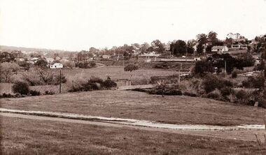
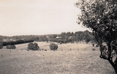
Photograph - Digital Image, Cherel Sartori, Looking east from Henry Street to the river 1956, 01/01/1956
Looking from Henry Street east to the Plenty River, 1956. The house was built 1917, at 112 Henry Street Greensborough by William Mitchell on the 60 acre dairy farm owned by Ethel and Walter Kell. This collection of photographs was copied by Cherel Sartori (who owned the house from 1990-2000), following a visit by Claude Amiet who lived in the house as a child in the early 20th century.An indication of the rural aspect of this area in the mid-20th century.Digital copy of black and white photographkell's cottage, claude amiet, cherel sartori -
 Greensborough Historical Society
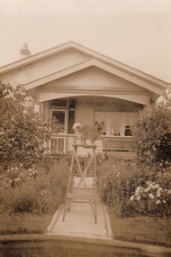
Photograph - Digital Image, Cherel Sartori, Electricity connected in Henry Street, 1950s, 1956c
Kell's Cottage with electricity connected 1950s. The house was built 1917, at 112 Henry Street Greensborough by William Mitchell on the 60 acre dairy farm owned by Ethel and Walter Kell. This collection of photographs was copied by Cherel Sartori (who owned the house from 1990-2000), following a visit by Claude Amiet who lived in the house as a child in the early 20th century.An indication of the rural aspect of this area in the mid-20th century.Digital copy of black and white photographkell's cottage, claude amiet, cherel sartori -
 Greensborough Historical Society
Photograph - Digital Image, Cherel Sartori, Paddock and gates in Henry Street, 1950s, 1956c
Paddock and driveway at Kell's Cottage 1950s. The house was built 1917, at 112 Henry Street Greensborough by William Mitchell on the 60 acre dairy farm owned by Ethel and Walter Kell. This collection of photographs was copied by Cherel Sartori (who owned the house from 1990-2000), following a visit by Claude Amiet who lived in the house as a child in the early 20th century.An indication of the rural aspect of this area in the mid-20th century.Digital copy of black and white photographkell's cottage, claude amiet, cherel sartori -
 Greensborough Historical Society
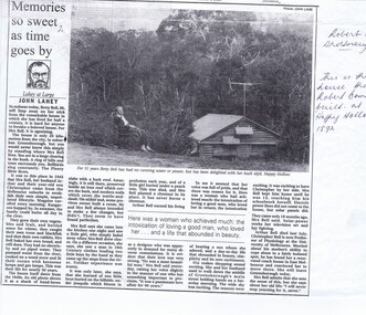
Newspaper clipping, Memories so sweet as time goes by, 24/03/1994
Newspaper article from 1994 recording the history of the Bell family at Happy Hollow.Happy Hollow was built in the late 1840's about 4 km north of Greensborough on the Plenty River. The article informs us that the Bell family moved there in 1943 and lived without power or running water at that site until March 1994 when Betty moved out.A copy of a black and white article from The Age newspaper. Includes text and photograph of Betty Bell at Happy Hollow farm.Biro inscriptions in title and highlighting throuhgout..happy hollow, plenty river, bell family, betty bell, . -
 Eltham District Historical Society Inc
Photograph, View of 'Willis Vale', Greensborough, 1906, 1906c
'Willis Vale' home of the Partington family is shown in this photograph as well as the area now known as Partington's Flat. The area was owned and farmed by the Partington family from the 1870s. Willis Vale was destroyed by fire in the 1960sBlack and white photograph copy originally located in a magnetic style album titled 'Greensborough Bypass 1990s 5' suffering significant degradation. No information contained in album or on reverse of photos except where noted. Relocated to archival photosafe storage.greensborough, partingtons flat, partington family, willis vale -
 Eltham District Historical Society Inc
Photograph, Pa, Greta & family (perhaps Crozier?)
Photo depicts possibly a family group of six of various ages standing in bush setting with buildings in the background. Verso inscription: Pa, Greta & family Cnr Susan & Bridge [Streets]. Is this photograph relating to the Crozier Farm House? This was located at this site 66 Susan Street till 2007 when it was demolished by Nillumbik Shire Council. Black and white photograph printed with white borders (one of a set of five). -
 Kiewa Valley Historical Society
Photograph Farm Land, Mount Beauty Acreage before Golf Course, Circa 1950
This photograph is a "snap shot" in time circa 1950s detailing the rural environment before the effects of the Kiewa Valley Hydro Scheme altered the basic rural setting of the valley. The golfing fairway was being mapped out on previous grazing land, before the laying of a golf course, for use by the construction workers and auxiliary administration employees of the Victorian State Electricity Commission. This photograph details a dramatic period in time which saw an enormous change to the exclusively rural area of the Kiewa Valley region in the mid 1900s. This change presented both physical and mental challenges to the existing quiet rural inhabitants of the valley. The State of Victoria had to make adjustments to the changing demands imposed by population and industrial expansions. The development of cleaner energy supplies to a growing population has its downside ,which ever way the intrusion into the "natural" landscape is made.Black and white photograph detailing surveyor posts for construction of golf course. Land used, before establishment of the Mount Beauty Village, as farming/grazing cattle and viewed towards Mount Bogong and its Alpine ranges. The photo is on 200gms paper and not on photographic paper.nilmount beauty in the 1940s - 1950s, grazing in the kiewa valley, sec victoria -
 Kiewa Valley Historical Society
Photograph of Kiewa Valley Panorama, Farming lands within the Kiewa Valley in1950s, Circa 1950
This photograph shows how (early to mid1900s), before the establishment of the Mount Beauty "gated" village, the Kiewa Valley was farmed and the scarce population was spread out over acres of productive land. This photograph catches a time before (what appeared to the local farmers as the invasion by a mass of construction workers) when this remote valley was part of a "lay back" rural landscape,occasionally visited by friends and some wayward tourists. The mountain ranges provided an adequate barrier against the way-would traveller. The immigration numbers coming into Australia was still quite small ( due to the "white" Australia policy) which was in force before World War II. After World War II a mass of displaced European refugees and migrants boosted the Australian population and provided for a greater degree of diverse professions and rural related work force.This photograph depicts the borderline in time between an exclusively rural based population and respective activities(early 1900s)to the present (2000 on wards) integrated village, tourist and retiree/holiday area. The time when land was exclusively used in agriculture is over and the impact of cheaper rural produce from Asian markets will see a shift of land useage and population activities. The Kiewa Valley is loosing its hiding place and is becoming more and more a source of untapped residential land. Black and white photograph of farming/grazing land useage, before the establishment of the Mount Beauty Village. Small pockets of residentual houses can be viewed. Road access (unsealed dirt) was typical of that provided in rural regions in the 1950s. The photo is on 200gms paper and not on photographic paper.kiewa valley in the early1900s, grazing in the kiewa valley, sec victoria -
 Kiewa Valley Historical Society
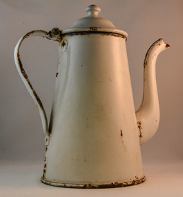
Pot Coffee, Circa 1950
This coffee pot was made for flat heating surfaces and not the open fire. The enamel coating was used as a thermal barrier to keep the contents hot. This could have been used as an all day coffee source for busy farm workers or breakfast and lunch times. When this pot was used at dinner time, it was a time period when dinner was more formal, with the whole family sitting at the dinner table. The white enamel would have been sufficient for the majority of households. When this pot was in use the dinner period was when the whole family was together and communication within the family was considered very important as a cohesive force. This was a time before television intruded into the atmosphere of relaying the day's activities to the whole family.In small rural communities within the Kiewa Valley a good cup of tea or coffee was a time for relaxation from the hard work of the day. This relaxation period was beneficial for not only the mind but also the body. This was particularly for the house bound mother with domestic chores that had, at this time in history not many "time saving" pieces of domestic equipment. A good pot of tea or coffee at "smoko" was a god sent. Although regarded by well groomed city folk that a coffee pot was for coffee only the less social etiquette standards of country folk permitted its use for tea. Versatility even within the household was of great benefit to the folk in the Kiewa Valley. This was even so for the immigrants that joined in and were warmly welcomed within this rural sector of Australia.This coffee pot is in the French style with a goose neck. It is fully coated in white enamel and has a concave bottom. It has a hinged lid and the main body has been rolled fastened to the bottom plate. The sandwiched steel body is approximately 1mm thick. The two piece neck has been welded together similarly the hinged lid and handle. Rivets are installed to the both bases of the handle. country kitchens, well heated coffee, coffee break in rural regions -
 Kiewa Valley Historical Society
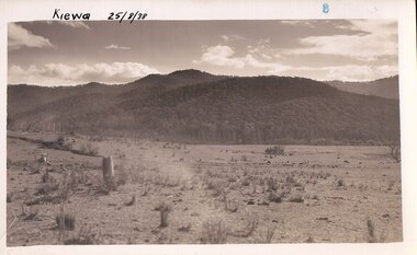
Photograph Farm Land, Kiewa, 25/8/38, circa 1938
This photograph was taken in august, 1938 some eight years prior to the establishment of Mt. Beauty as a township. The area was still being used for grazing cattle and the land was eventually acquired from the local land owners by the State Electricity Commission. The construction of the road, from Tawonga to the High Plains, was commenced in April of 1938. This allowed men and heavy equipment to be transported to the work sites for the construction of the Kiewa Hydro Electric Scheme. Prior to this access was by bridle trail, either on horse back or by foot. By 1946 housing construction had commenced for the new town of Mt. Beauty and by 1948 street construction in the southern part of the town was completed as far as Hill Street.This is an important photograph as it shows the upper Kiewa Valley and the site for Mt. Beauty as it was before the establishment of the town. The land has been cleared of natural vegetation and used for grazing cattle.Black and white photograph of farmland, cattle in the distance, hills in the backgroundHandwritten in the upper left hand corner, in black ink, 'Kiewa 25/8/38'. The number 8 has been stamped in the upper right hand side of the photograph. On the back have been stamped the words Velox, indicating the type of photographic paper.kiewa, mt. beauty, construction, grazing, secv -
 Eltham District Historical Society Inc
Photograph, Maurie Fabbro at age 20 at Fabbro's farm in Bell Street, Eltham, 1940, 1940
The site of the Fabbro farm (Diamond Creek side land) is now called Barrack Bushlands. It is doubtful that Fabbro's farm holding was ever called Barrak Park, This title is fairly recent after the Shire of Eltham purchased the land, including the last section in 1993/94. About this time the area on the west side of Falkiner Street was purchased by a private developer and developed as housing. The area in Bell Street opposite the Eltham High School was purchased by the State Government is recent years and is called Fabbro Fields. The Fabbro Family operated their farm in Bell Street, Eltham. Maurice Joseph Fabbro (Mario) was born 19 January 1920 and passed away 19 November 20091 black and white photographfabbro's farm, maurice fabbro -
 Eltham District Historical Society Inc
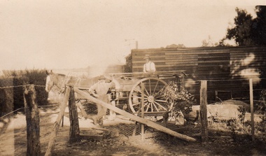
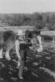
Photograph, Guildo Fabbro, Falkiner Street, Eltham with Clydesdale horse
Guildo Fabbro, Falkiner Street, Eltham with Clydesdale horse with harness in field. The site of the Fabbro farm (Diamond Creek side land) is now called Barrack Bushlands. It is doubtful that Fabbro's farm holding was ever called Barrak Park, This title is fairly recent after the Shire of Eltham purchased the land, including the last section in 1993/94. About this time the area on the west side of Falkiner Street was purchased by a private developer and developed as housing. The area in Bell Street opposite the Eltham High School was purchased by the State Government is recent years and is called Fabbro Fields. The Fabbro Family operated their farm in Bell Street, Eltham. 1 black and white photographfabbro's farm, guido fabbro, bell street, clydesdale horse -
 Eltham District Historical Society Inc
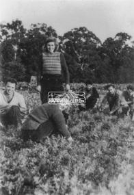
Photograph, At Bell Street; from left: Maurie Fabbro, Myra Skipper, Unknown, Arthur Munday, Ian Robertson. Helen Comprione in front
At Bell Street, Fabbro Farm, Eltham; from left: Maurie Fabbro, Myra Skipper, Unknown, Arthur Munday, Ian Robertson. Helen Comprione in front - probably helping to pick a crop. The site of the Fabbro farm (Diamond Creek side land) is now called Barrack Bushlands. It is doubtful that Fabbro's farm holding was ever called Barrak Park, This title is fairly recent after the Shire of Eltham purchased the land, including the last section in 1993/94. About this time the area on the west side of Falkiner Street was purchased by a private developer and developed as housing. The area in Bell Street opposite the Eltham High School was purchased by the State Government is recent years and is called Fabbro Fields. The Fabbro Family operated their farm in Bell Street, Eltham. 1 black and white photographfabbro's farm, guido fabbro, bell street, arhur munday, eltham, helen comprione, ian robertson, maurice fabbro, myra skipper, picking, farming -
 Eltham District Historical Society Inc
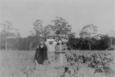
Photograph, From left: Unknown, Mario Fabbro and possibly Helen Skipper, Bell Street, Eltham
At Bell Street, Fabbro Farm, Eltham; From left: Unknown, Mario Fabbro and possibly Helen Skipper, standing in the middle of a vegetable crop. The site of the Fabbro farm (Diamond Creek side land) is now called Barrack Bushlands. It is doubtful that Fabbro's farm holding was ever called Barrak Park, This title is fairly recent after the Shire of Eltham purchased the land, including the last section in 1993/94. About this time the area on the west side of Falkiner Street was purchased by a private developer and developed as housing. The area in Bell Street opposite the Eltham High School was purchased by the State Government is recent years and is called Fabbro Fields. The Fabbro Family operated their farm in Bell Street, Eltham. 1 black and white photographfabbro's farm, bell street, eltham, maurice fabbro, farming, helen skipper, vegetables