Showing 434 items matching "trams -- kew"
-
 Kew Historical Society Inc
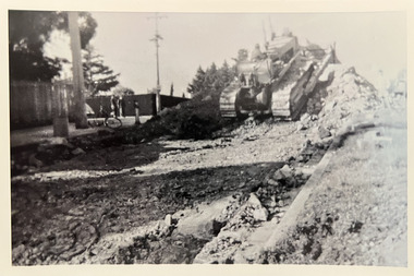
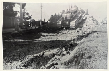
Photograph - Road-making, Studley Park Road, c. 1960
Tom Bentley (1912-1993) was born in Lancashire (UK). From circa 1951, he was the Overseer/Superintendent of Outdoor Works for Kew City Council. Until his retirement in the 1970s, he was based at the Kew Council Depot, located in the former MTB Horse Tram Depot on the corner of Disraeli and High Streets, Kew. Accompanying the set of twelve photographs is a 12-page illustrated biography of the Bentley and Plumridge families, separately kept in the 'Bentley' subject file.Duplicate black and white positive print photograph of road works in Studley Park Road, Kew, carried out under the supervision of Tom Bentley, Overseer/Superintendent of Outdoor Works for the City of Kew. The location at which the photograph was taken is believed, by the donor, to be in the vicinity of Tara Hall (dem. 1960).city of kew, public works, road-making, studley park road, tom bentley -
 Kew Historical Society Inc
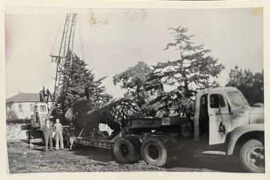
Photograph - Loading a palm tree from Tara Hall, Studley Park Road, c. 1960
Tom Bentley (1912-1993) was born in Lancashire (UK). From circa 1951, he was the Overseer/Superintendent of Outdoor Works for Kew City Council. Until his retirement in the 1970s, he was based at the Kew Council Depot, located in the former MTB Horse Tram Depot on the corner of Disraeli and High Streets, Kew. Accompanying the set of twelve photographs is a 12-page illustrated biography of the Bentley and Plumridge families, separately kept in the 'Bentley' subject file.Duplicate black and white positive print photograph of public works in Studley Park Road, Kew, carried out under the supervision of Tom Bentley, Overseer/Superintendent of Outdoor Works for the City of Kew. The location at which the photograph was taken is believed, by the donor, to be in the vicinity of Tara Hall (dem. 1960). The palm tree on the back of the Council vehicle was believed to have been taken by Council from Tara Hall and relocated to the Alexandra Gardens.city of kew, public works, studley park road, tom bentley, tara hall -
 Kew Historical Society Inc
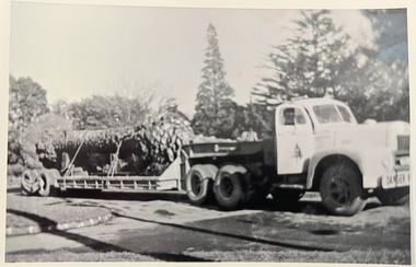
Photograph - Transporting a palm tree from Tara Hall, Studley Park Road, c. 1960
Tom Bentley (1912-1993) was born in Lancashire (UK). From circa 1951, he was the Overseer/Superintendent of Outdoor Works for Kew City Council. Until his retirement in the 1970s, he was based at the Kew Council Depot, located in the former MTB Horse Tram Depot on the corner of Disraeli and High Streets, Kew. Accompanying the set of twelve photographs is a 12-page illustrated biography of the Bentley and Plumridge families, separately kept in the 'Bentley' subject file.Duplicate black and white positive print photograph of public works in Studley Park Road, Kew, carried out under the supervision of Tom Bentley, Overseer/Superintendent of Outdoor Works for the City of Kew. The location at which the photograph was taken is believed, by the donor, to be in the vicinity of Tara Hall (dem. 1960). The palm tree on the back of the Council vehicle was believed to have been taken by Council from Tara Hall and relocated to the Alexandra Gardens.city of kew, public works, studley park road, tom bentley, tara hall -
 Kew Historical Society Inc
Photograph - Road works in Studley Park Road, c. 1960
Tom Bentley (1912-1993) was born in Lancashire (UK). From circa 1951, he was the Overseer/Superintendent of Outdoor Works for Kew City Council. Until his retirement in the 1970s, he was based at the Kew Council Depot, located in the former MTB Horse Tram Depot on the corner of Disraeli and High Streets, Kew. Accompanying the set of twelve photographs is a 12-page illustrated biography of the Bentley and Plumridge families, separately kept in the 'Bentley' subject file.Duplicate black and white positive print photograph of road works in Studley Park Road, Kew, carried out under the supervision of Tom Bentley, Overseer/Superintendent of Outdoor Works for the City of Kew. The location at which the photograph was taken is believed, by the donor, to be in the vicinity of Tara Hall (dem. 1960). The photograph shows two Council vehicles.city of kew, public works, studley park road, tom bentley, road works -
 Kew Historical Society Inc
Photograph - Road works in Studley Park Road, c. 1960
Tom Bentley (1912-1993) was born in Lancashire (UK). From circa 1951, he was the Overseer/Superintendent of Outdoor Works for Kew City Council. Until his retirement in the 1970s, he was based at the Kew Council Depot, located in the former MTB Horse Tram Depot on the corner of Disraeli and High Streets, Kew. Accompanying the set of twelve photographs is a 12-page illustrated biography of the Bentley and Plumridge families, separately kept in the 'Bentley' subject file.Duplicate black and white positive print photograph of road works in Studley Park Road, Kew, carried out under the supervision of Tom Bentley, Overseer/Superintendent of Outdoor Works for the City of Kew. The location at which the photograph was taken is believed, by the donor, to be in the vicinity of Tara Hall (dem. 1960). The photograph shows a Council vehicles shifting soil.city of kew, public works, studley park road, tom bentley, road works -
 Kew Historical Society Inc
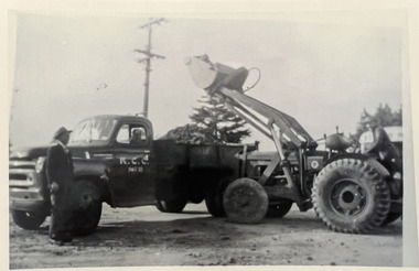
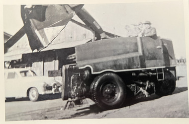
Photograph - City of Kew vehicles and workers, c. 1960
Tom Bentley (1912-1993) was born in Lancashire (UK). From circa 1951, he was the Overseer/Superintendent of Outdoor Works for Kew City Council. Until his retirement in the 1970s, he was based at the Kew Council Depot, located in the former MTB Horse Tram Depot on the corner of Disraeli and High Streets, Kew. Accompanying the set of twelve photographs is a 12-page illustrated biography of the Bentley and Plumridge families, separately kept in the 'Bentley' subject file.Duplicate black and white positive print photograph of road works in Studley Park Road, Kew, carried out under the supervision of Tom Bentley, Overseer/Superintendent of Outdoor Works for the City of Kew. The photograph shows a Council-owned front end loader and a Council trailer.city of kew, public works, tom bentley -
 Kew Historical Society Inc
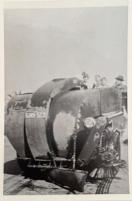
Photograph - City of Kew steamroller and workers, c. 1960
Tom Bentley (1912-1993) was born in Lancashire (UK). From circa 1951, he was the Overseer/Superintendent of Outdoor Works for Kew City Council. Until his retirement in the 1970s, he was based at the Kew Council Depot, located in the former MTB Horse Tram Depot on the corner of Disraeli and High Streets, Kew. Accompanying the set of twelve photographs is a 12-page illustrated biography of the Bentley and Plumridge families, separately kept in the 'Bentley' subject file.Duplicate black and white positive print photograph of road works in Studley Park Road, Kew, carried out under the supervision of Tom Bentley, Overseer/Superintendent of Outdoor Works for the City of Kew. The photograph shows a Council-owned steamroller used for road construction.city of kew, public works, tom bentley, road works, steamrollers -
 Kew Historical Society Inc
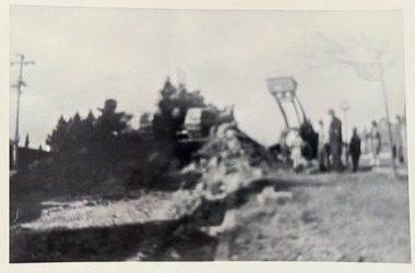
Photograph - Road construction in Studley Park Road, c. 1960
Tom Bentley (1912-1993) was born in Lancashire (UK). From circa 1951, he was the Overseer/Superintendent of Outdoor Works for Kew City Council. Until his retirement in the 1970s, he was based at the Kew Council Depot, located in the former MTB Horse Tram Depot on the corner of Disraeli and High Streets, Kew. Accompanying the set of twelve photographs is a 12-page illustrated biography of the Bentley and Plumridge families, separately kept in the 'Bentley' subject file.Duplicate black and white positive print photograph of road works in Studley Park Road, Kew, carried out under the supervision of Tom Bentley, Overseer/Superintendent of Outdoor Works for the City of Kew. The blurred photograph shows Council-owned vehicles used for road construction and council workers.city of kew, public works, tom bentley, road works -
 Kew Historical Society Inc
Journal, Newsletter No.147, June 2024
Tram tracks in Boroondara [electrification of] / Robert Baker pp1-2. History News - Conservation [Henty Family Costume Collection, Community Heritage Grant application - National Library of Australia]; New Members; Donations to the Collection / p3. The Voyage of the John Bunyan / David White pp4-5. Family records: The diary of Mrs Henry Henty of Tarring / Suzanne McWha pp6-8. Sir Rupert 'Dick' Hamer AC KCMG ED / John Torpey pp8-9. As it happened 100 years ago [H.C.A. Harrison, Empire Day, Motor accident, Widening of High Street [Kew], Death of Cr [Sir] Henry [de Castres] Kellett, Bt / David White p.9. Branching out: the Coles family of Kew / Desley Reid pp.10-11. Membership and Donations / p12.Published quarterly since 1977, the newsletters of the Kew Historical Society contain significant research by members exploring relevant aspects of the Victorian and Australian Framework of Historical Themes. Frequently, articles on people, places and artefacts are the only source of information about an aspect of Kew, and Melbourne’s history.non-fictionTram tracks in Boroondara [electrification of] / Robert Baker pp1-2. History News - Conservation [Henty Family Costume Collection, Community Heritage Grant application - National Library of Australia]; New Members; Donations to the Collection / p3. The Voyage of the John Bunyan / David White pp4-5. Family records: The diary of Mrs Henry Henty of Tarring / Suzanne McWha pp6-8. Sir Rupert 'Dick' Hamer AC KCMG ED / John Torpey pp8-9. As it happened 100 years ago [H.C.A. Harrison, Empire Day, Motor accident, Widening of High Street [Kew], Death of Cr [Sir] Henry [de Castres] Kellett, Bt / David White p.9. Branching out: the Coles family of Kew / Desley Reid pp.10-11. Membership and Donations / p12.kew historical society (vic.) -- periodicals., kew historical society (vic.) -- newsletters, kew historical society (vic.) -- journals -
 Kew Historical Society Inc
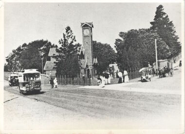
Photograph, Entrance to Boroondara General Cemetery, c.1900
This work forms part of the collection assembled by the historian Dorothy Rogers, that was donated to the Kew Historical Society by her son John Rogers in 2015. The manuscripts, photographs, maps, and documents were sourced by her from both family and local collections or produced as references for her print publications. Many were directly used by Rogers in writing ‘Lovely Old Homes of Kew’ (1961) and 'A History of Kew' (1973), or the numerous articles on local history that she produced for suburban newspapers. Most of the photographs in the collection include detailed annotations in her hand. The Rogers Collection provides a comprehensive insight into the working habits of a historian in the 1960s and 1970s. Together it forms the largest privately-donated collection within the archives of the Kew Historical SocietyThe entrance to Kew cemetery showing the clock tower and horse trams in High Street. The horse tram was at this time the only public transport by which visitors could reach the cemetery. The photograph postdates the construction of the surrounding brick fence which was constructed in 1895-96. "Views Boroondara Cemetery. Land set aside 1859. Photo after brick wall was built."boroondara general cemetery, dorothy rogers -
 Kew Historical Society Inc
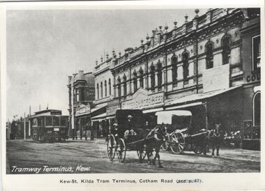
Postcard, Tramway Terminus, Kew, 1913
... , Kew. Kew-St Kilda Tram Terminus, Cotham Road (see p.47)"... road (kew) dorothy rogers postcards - kew (vic.) "tram about ...This work forms part of the collection assembled by the historian Dorothy Rogers, that was donated to the Kew Historical Society by her son John Rogers in 2015. The manuscripts, photographs, maps, and documents were sourced by her from both family and local collections or produced as references for her print publications. Many were directly used by Rogers in writing ‘Lovely Old Homes of Kew’ (1961) and 'A History of Kew' (1973), or the numerous articles on local history that she produced for suburban newspapers. Most of the photographs in the collection include detailed annotations in her hand. The Rogers Collection provides a comprehensive insight into the working habits of a historian in the 1960s and 1970s. Together it forms the largest privately-donated collection within the archives of the Kew Historical Society.A copy of a book plate in Vaughan in 'Kew's Civic Century' (1960) which was itself a copy of a postcard from circa 1913."tram about 1913. Terminus, Cotham Road. Tramway Terminus, Kew. Kew-St Kilda Tram Terminus, Cotham Road (see p.47)"cotham road (kew), dorothy rogers, postcards - kew (vic.) -
 Kew Historical Society Inc
Plan - Subdivision Plan, Goldthorns House Estate, 1940
Pru Sanderson, in her groundbreaking ‘City of Kew Urban Conservation Study : Volume 2 - Development History’ (1988), summarised the periods of urban development and subdivisions of land in Kew. The periods that she identified included 1845-1880, 1880-1893, 1893-1921, 1921-1933, 1933-1943, and Post-War Development. These periods were selected as they represented periods of rapid growth or decline in urban development. An obvious starting point for Sanderson’s groupings involved population growth and the associated economic cycles. These cycles also highlighted urban expansion onto land that was predominantly rural, although in other cases it represented the decline and breakup of large estates. A number of the plans in the Kew Historical Society’s collection can also be found in other collections, such as those of the State Library of Victoria and the Boroondara Library Service. A number are however unique to the collection.The Kew Historical Society collection includes almost 100 subdivision plans pertaining to suburbs of the City of Melbourne. Most of these are of Kew, Kew East or Studley Park, although a smaller number are plans of Camberwell, Deepdene, Balwyn and Hawthorn. It is believed that the majority of the plans were gifted to the Society by persons connected with the real estate firm - J. R. Mathers and McMillan, 136 Cotham Road, Kew. The Plans in the collection are rarely in pristine form, being working plans on which the agent would write notes and record lots sold and the prices of these. The subdivision plans are historically significant examples of the growth of urban Melbourne from the beginning of the 20th Century up until the 1980s. A number of the plans are double-sided and often include a photograph on the reverse. A number of the latter are by noted photographers such as J.E. Barnes.The first subdivision of Goldthorns created the Goldthorns Hill Estate. Following that subdivision, seven additional lots were offered between Normanby Road, Argyle Road and Lady Loch’s Drive on the proviso that the estate, including Goldthorns was not sold as a single lot. The subdivision plan advises that the lots are situated in one of the most charming and popular residential areas in Kew and is surrounded by modern homes. Typically, the subdivision plan proposes the advantage of its proximity to Cotham Road and the tram to Collins Street. Because of the elevation of Goldthorns, much is made of the ‘bright, sunny and extensive outlook to the Northern Ranges’ and that it overlooks the Yarra Valley. One of the more interesting aspects of the plan is that it shows the outline of Goldthorns in the mid to late 1920s. Its profile today remains virtually the same."Goldthorns" House Estate at topsubdivision plans - kew, goldthorns house estate -
 Kew Historical Society Inc
Plan - Subdivision Plan, Wimba Estate, Kew, c.1925-c.1929, ca. 1925-ca. 1929
Pru Sanderson, in her groundbreaking ‘City of Kew Urban Conservation Study : Volume 2 - Development History’ (1988), summarised the periods of urban development and subdivisions of land in Kew. The periods that she identified included 1845-1880, 1880-1893, 1893-1921, 1921-1933, 1933-1943, and Post-War Development. These periods were selected as they represented periods of rapid growth or decline in urban development. An obvious starting point for Sanderson’s groupings involved population growth and the associated economic cycles. These cycles also highlighted urban expansion onto land that was predominantly rural, although in other cases it represented the decline and breakup of large estates. A number of the plans in the Kew Historical Society’s collection can also be found in other collections, such as those of the State Library of Victoria and the Boroondara Library Service. A number are however unique to the collection.Subdivision plans are historically important documents used as evidence of the growth of suburbs in Australia. They frequently provide information about when the land was sold on which a built structure was subsequently constructed as well as evidence relating to surveyors and real estate and financial agents. The numerous subdivision plans in the Kew Historical Society's collection represent working documents, ranging from the initial sketches made in planning a subdivision to printed plans on which auctioneers or agents listed the prices for which individual lots were sold. In a number of cases, the reverse of a subdivision plan in the collection includes a photograph of a house that was also for sale by the agent. These photographs provide significant heritage information relating house design and decoration, fencing and household gardens.In 1925, the City of Kew called for tenders for the construction of Wimba Avenue, Cadow Street and Lalla Street. Subsequent advertisements for the sale of land in Wimba Avenue continued from 1926 to 1929. The 18 lots (and a further five allotments on the eastern side of the street) offered for sale were unofficially described in the subdivision plan as the ‘Wimba Estate’. These lots began in Park Hill Road and extended almost to Cotham Road. The subdivision took its name from the house ‘Wimba’ in Cotham Road, which may have formed the southern boundary of the subdivision. (Wimba, at 235 Cotham Road was constructed between 1862-70). The Plan highlights the proximity and advantage of ‘electric’ trams in Cotham and Glenferrie Roads, and the Kew and Glenferrie Railway Stations. An oddity in the Plan is the reference to the electric tram terminus at Burke Road, given that the tramline had already been extended to Mont Albert in 1916.wimba estate, subdivision plans - kew, parkhill road – kew (vic.), normanby road – kew (vic.), wimba avenue – kew (vic.) -
 Kew Historical Society Inc
Plan - Subdivision Plan, Shop Sites, East Kew, c.1927
Subdivision plans are historically important documents used as evidence of the growth of suburbs in Australia. They frequently provide information about when the land was sold on which a built structure was subsequently constructed as well as evidence relating to surveyors and real estate and financial agents. The numerous subdivision plans in the Kew Historical Society's collection represent working documents, ranging from the initial sketches made in planning a subdivision to printed plans on which auctioneers or agents listed the prices for which individual lots were sold. In a number of cases, the reverse of a subdivision plan in the collection includes a photograph of a house that was also for sale by the agent. These photographs provide significant heritage information relating house design and decoration, fencing and household gardens.This is one of a small number of subdivision plans for commercial property in the collection. The subdivision proposed to create six shop sites in High Street between the Harp of Erin and Station Street. The plan shows this stretch of High Street, East Kew already lined with shops that include the hotel on the corner, the new State Savings Bank, a dentist’s surgery and Lambert’s Store. The High Street Tram was to reach Burke Road in 1925, so the proposed subdivision must postdate that event, and the opening of the Bank in 1926.subdivision plans - east kew, high street - east kew -
 Kew Historical Society Inc
Plan - Subdivision Plan, Eastlawn Estate, 1914
Subdivision plans are historically important documents used as evidence of the growth of suburbs in Australia. They frequently provide information about when the land was sold on which a built structure was subsequently constructed as well as evidence relating to surveyors and real estate and financial agents. The numerous subdivision plans in the Kew Historical Society's collection represent working documents, ranging from the initial sketches made in planning a subdivision to printed plans on which auctioneers or agents listed the prices for which individual lots were sold. In a number of cases, the reverse of a subdivision plan in the collection includes a photograph of a house that was also for sale by the agent. These photographs provide significant heritage information relating house design and decoration, fencing and household gardens.The ‘Eastlawn Estate’ was surveyed and ready for auction in March 1914, three months before the outbreak of World War I. Sixty-six allotments, created on the ‘order of Mr & Miss Preston’ surrounded the mansion of Woodlands in Harp Road. Woodlands formed part of the Estate, being advertised as lot 1. The allotments faced High, Station and Wright Streets, Harp and Normanby Roads, and Woodlands Avenue. Pru Sanderson in the Kew Conservation Study (Vol.2, 1988) wrote that the Eastlawn Estate ‘covered the western half of the failed Harp of Erin Estate’. Contemporary advertisements promoted the Eastlawn Estate as: ‘There will be no more convenient district nor pleasant Suburb than East Kew for the busy business man. When the Electric Tram is laid, he will be able to journey quickly and pleasantly direct from Collins Street to his home in the Eastlawn Estate in about 20 minutes’. The actual plans of subdivision were included in advertisements in The Argus and in the local newspapers.subdivision plans - east kew, eastlawn estate -
 Kew Historical Society Inc
Plan - Subdivision Plan, Harvest Home Estate, 1919
Pru Sanderson, in her groundbreaking ‘City of Kew Urban Conservation Study : Volume 2 - Development History’ (1988), summarised the periods of urban development and subdivisions of land in Kew. The periods that she identified included 1845-1880, 1880-1893, 1893-1921, 1921-1933, 1933-1943, and Post-War Development. These periods were selected as they represented periods of rapid growth or decline in urban development. An obvious starting point for Sanderson’s groupings involved population growth and the associated economic cycles. These cycles also highlighted urban expansion onto land that was predominantly rural, although in other cases it represented the decline and breakup of large estates. A number of the plans in the Kew Historical Society’s collection can also be found in other collections, such as those of the State Library of Victoria and the Boroondara Library Service. A number are however unique to the collection.The Kew Historical Society collection includes almost 100 subdivision plans pertaining to suburbs of the City of Melbourne. Most of these are of Kew, Kew East or Studley Park, although a smaller number are plans of Camberwell, Deepdene, Balwyn and Hawthorn. It is believed that the majority of the plans were gifted to the Society by persons connected with the real estate firm - J. R. Mathers and McMillan, 136 Cotham Road, Kew. The Plans in the collection are rarely in pristine form, being working plans on which the agent would write notes and record lots sold and the prices of these. The subdivision plans are historically significant examples of the growth of urban Melbourne from the beginning of the 20th Century up until the 1980s. A number of the plans are double-sided and often include a photograph on the reverse. A number of the latter are by noted photographers such as J.E. Barnes.The ‘Harvest Home Estate’ was advertised as being a subdivision in East Kew. Now, Campbell and Owen Streets on which the allotments were located are classed as being in Kew. The Estate included 11 residential allotments abutting the Outer Circle Railway line [at the end of Owen Street]. Understandably, the vendors focused on the availability of transport by tram, noting that the Estate was near the High Street tram terminus at the Harp of Erin. A small note on the subdivision advises that the Cotham Road tram was only 3 minutes away. The location – ‘The most elevated position in lovely Kew’ – was also promoted as an advantage.subdivision plans - east kew, harvest home estate -
 Kew Historical Society Inc
Plan, J R Mathers & McMillan, 5 Splendid vVlla Allotments,: Segtoune St. & Windsor St., Kew, 1928
Prue Sanderson, in her groundbreaking ‘City of Kew Urban Conservation Study : Volume 2 - Development History’ (1988), summarised the periods of urban development and subdivisions of land in Kew. The periods that she identified included 1845-1880, 1880-1893, 1893-1921, 1921-1933, 1933-1943, and Post-War Development. These periods were selected as they represented periods of rapid growth or decline in urban development. An obvious starting point for Sanderson’s groupings involved population growth and the associated economic cycles. These cycles also highlighted urban expansion onto land that was predominantly rural, although in other cases it represented the decline and breakup of large estates. A number of the plans in the Kew Historical Society’s collection can also be found in other collections, such as those of the State Library of Victoria and the Boroondara Library Service. A number are however unique to the collection.Subdivision plans are historically important documents used as evidence of the growth of suburbs in Australia. They frequently provide information about when the land was sold on which a built structure was subsequently constructed as well as evidence relating to surveyors and real estate and financial agents. The numerous subdivision plans in the Kew Historical Society's collection represent working documents, ranging from the initial sketches made in planning a subdivision to printed plans on which auctioneers or agents listed the prices for which individual lots were sold. In a number of cases, the reverse of a subdivision plan in the collection includes a photograph of a house that was also for sale by the agent. These photographs provide significant heritage information relating house design and decoration, fencing and household gardens.In 1928, five residential allotments bordering Segtoune and Windsor Streets were advertised for sale as part of a subdivision. Four of the blocks faced Segtoune Avenue. The auctioneers proclaimed the advantages of the sites: ‘Situate one minute from the High Street Electric Tram, which now runs direct to Spencer Street via Bridge Road and Flinders Street. Opposite the East Kew Railway Station (Outer Circle Line), which may be reopened In connection with the new Line from Kew to Doncaster; Adjacent lo the Kew Recreation Reserve, Sports Oval, and Swimming Bath; Half Minute from the Shopping Centre of East Kew, Accessible to the State School and Other Educational Centres’. The Harp of Erin Hotel and the route of the Outer Circle Railway line are marked on the plan. The Recreation Reserve and Sport Oval refer to Victoria Park. The Swimming Baths were located on the site of the current Kew Recreation Centre.subdivision plans - kew, segtoune street -- kew (vic.), windsor street -- kew (vic.) -
 Kew Historical Society Inc
Plan - Subdivision Plan, Goldthorns Hill Estate, 1925
Pru Sanderson, in her groundbreaking ‘City of Kew Urban Conservation Study : Volume 2 - Development History’ (1988), summarised the periods of urban development and subdivisions of land in Kew. The periods that she identified included 1845-1880, 1880-1893, 1893-1921, 1921-1933, 1933-1943, and Post-War Development. These periods were selected as they represented periods of rapid growth or decline in urban development. An obvious starting point for Sanderson’s groupings involved population growth and the associated economic cycles. These cycles also highlighted urban expansion onto land that was predominantly rural, although in other cases it represented the decline and breakup of large estates. A number of the plans in the Kew Historical Society’s collection can also be found in other collections, such as those of the State Library of Victoria and the Boroondara Library Service. A number are however unique to the collection.The Kew Historical Society collection includes almost 100 subdivision plans pertaining to suburbs of the City of Melbourne. Most of these are of Kew, Kew East or Studley Park, although a smaller number are plans of Camberwell, Deepdene, Balwyn and Hawthorn. It is believed that the majority of the plans were gifted to the Society by persons connected with the real estate firm - J. R. Mathers and McMillan, 136 Cotham Road, Kew. The Plans in the collection are rarely in pristine form, being working plans on which the agent would write notes and record lots sold and the prices of these. The subdivision plans are historically significant examples of the growth of urban Melbourne from the beginning of the 20th Century up until the 1980s. A number of the plans are double-sided and often include a photograph on the reverse. The Goldthorns Hill Estate subdivision was first put up for auction in 1925. The subdivision took its name from the mansion ‘Goldthorns’, shown on the plan between Normanby Road and Lady Loch’s Drive. Contemporary advertisements describe forty-three home sites being fro sale, yet only forty-one appear on this plan. Buyers were lured by the prospect of the proposed extension of the Burke Road tram to High Street. Discerning buyers were advised that only one house could be built per allotment, and that houses needed to be constructed of brick, stone or concrete and have a slate or tiled roof.goldthorns avenue -- kew east (vic.), lady loch drive -- kew east (vic.), argyle road -- kew east (vic.), lady brassey drive -- kew east (vic.), campbell street -- kew east (vic.), goldthorns -- kew (vic.), subdivisions -- kew east (viv.), goldthorns hill estate -
 Kew Historical Society Inc
Plan - Subdivision Plan, Jas R Mathers Son & McMillan, East Kew Tramway Estate, 1915
Pru Sanderson, in her groundbreaking ‘City of Kew Urban Conservation Study : Volume 2 - Development History’ (1988), summarised the periods of urban development and subdivisions of land in Kew. The periods that she identified included 1845-1880, 1880-1893, 1893-1921, 1921-1933, 1933-1943, and Post-War Development. These periods were selected as they represented periods of rapid growth or decline in urban development. An obvious starting point for Sanderson’s groupings involved population growth and the associated economic cycles. These cycles also highlighted urban expansion onto land that was predominantly rural, although in other cases it represented the decline and breakup of large estates. A number of the plans in the Kew Historical Society’s collection can also be found in other collections, such as those of the State Library of Victoria and the Boroondara Library Service. A number are however unique to the collection.The Kew Historical Society collection includes almost 100 subdivision plans pertaining to suburbs of the City of Melbourne. Most of these are of Kew, Kew East or Studley Park, although a smaller number are plans of Camberwell, Deepdene, Balwyn and Hawthorn. It is believed that the majority of the plans were gifted to the Society by persons connected with the real estate firm - J. R. Mathers and McMillan, 136 Cotham Road, Kew. The Plans in the collection are rarely in pristine form, being working plans on which the agent would write notes and record lots sold and the prices of these. The subdivision plans are historically significant examples of the growth of urban Melbourne from the beginning of the 20th Century up until the 1980s. A number of the plans are double-sided and often include a photograph on the reverse. A number of the latter are by noted photographers such as J.E. Barnes.The East Kew Tramway Estate was a subdivision of two separate parcels of land between Adeney Avenue and Normanby Road. The larger section included 54 lots facing Adeney Avenue, Argyle Road, and Campbell, Hunter and Wishart Streets. [Hunter and Wishart Streets were created as part of the subdivision.] A further 17 allotments faced Normanby Road, Hubert and Campbell Streets. [The name of Hubert Street was later to be changed to Cecil Street.] The promotion of the sale referred to the advantages of living between two tram routes, in High Street and Cotham Road. On the plan, quaintly drawn trams mark these routes. Also on the plan is the route of part of the Outer Circle [Railway] Line.east kew tramway estate, subdivision plans - east kew -
![Harp Junction [East Kew]](/media/collectors/550653872162f11fb04854aa/items/58cf089ed0ce9809d8713015/item-media/58cf59f9d0ce603314508da0/item-fit-380x285.jpg) Kew Historical Society Inc
Kew Historical Society IncPhotograph, Harp Junction [East Kew], 1910-1930
The Harp Junction, East KewAnnotations on reverse "KH-73. View from Junction of High St (then Bulleen Rd.) & Strathalbyn St. Kew. Looking toward Boroondara Cemetery. Wall in picture is side of bridge over Outer Circle Railway. Trams later cut across this curve."high street (kew), strathalbyn street (kew east), harp of erin hotel (kew) -
![Harp Junction [Kew East]](/media/collectors/550653872162f11fb04854aa/items/58cf094bd0ce9809d8715cf3/item-media/58cf59d0d0ce5d331467358d/item-fit-380x285.jpg) Kew Historical Society Inc
Kew Historical Society IncPhotograph, Harp Junction [Kew East], 1910-1930
Kew Junction at this stage was a tram terminusThe Harp Junction, East Kew.Annotation on reverse: "East Kew - looking towards city from harp of Erin Hotel - note wooden fence."harp of erin hotel (kew), high street (kew) -
 Kew Historical Society Inc
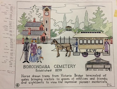
Work on paper, Joy Stewart, 4. Boroondara Cemetery, established 1859, 1988
Kew Tapestry The eight panels depict the history of Kew. This was a 1988 Australian Bi-Centennial Project carried out under the auspices of City of Kew Council and the Kew Historical Society Incorporated. Nearly 600 citizens including many children participated in the production by adding a few or more stitches. A book records their names and the panels upon which they worked. Artist: Joy Stewart Co-ordinator: Dorothy BenyeiSydney Joy (Joy) Stewart was born in Melbourne 1925. She studied at Swinburne Technical College Art School from 1941-1945, then the National Gallery Art School 1946-1948. Her career included employment positions as a display artist, designer/painter, gallery assistant, and art teacher. Joy relocated to Cairns in 1981. Solo exhibitions in Melbourne and Cairns, including 'Done By Me' at Cairns Regional Gallery in 1999. Group exhibitions at Cairns Regional Gallery, 'The Fish John West Regrets, 1993' and 'Facets of Life' 1994. Joy Stewart died in Cairns in 2018.4. Boroondara Cemetery, established 1859. A Handcoloured cartoon created by the artist Joy Stewart as a template for the fourth of a series of embroidered panels depicting the history of Kew. Wool colour codes at left. Inscription: "BOROONDARA CEMETERY, Established 1859. Horse drawn trams from Victoria Bridge terminated at gates bringing visitors to graves of relatives and friends; and sightseers to view the impressive pioneer memorials". Signed by the artist "(c) JStewart, 1988". bicentennial project (kew), boroondara general (kew) cemetery -
 Kew Historical Society Inc
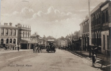
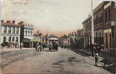
Postcard, Main Street, Kew, c.1890
The Kew Historical Society's Pictures Collection is comprised of photographs, postcards and original works of art. The postcards include original (mainly) images dating from the 1900s to the present. A number of postcards, some of which have numerous variants, were published as parts of series. Others are original images customised as postcards. Many of the postcards in the collection depict places within the suburbs of Kew and Kew East. Others depict locations in Victoria or internationally. A monochrome postcard showing Main Street [High Street], Kew, looking south west from near its junction with Cotham Road, showing: Ryan’s Council Family Hotel, T. G. Jellis (baker, confectioner), Herbert King (undertaker), L. Merritt (boot warehouse), horse tram, horse drawn vehicles and pedestrians.Post card text addressed to Miss Newell of Balmain.high street - kew, cotham road - kew, tramways - kew -
 Kew Historical Society Inc
Postcard, Victoria Street Bridge, Collingwood, 1905-1913
Victoria Bridge is a riveted and welded steel Warren truss bridge over the Yarra River completed in 1884 to a design by Fraser & Chase following a controversial design competition held in 1880. Funds for the bridge's construction were provided by the councils of Collingwood, Hawthorn, Kew and Richmond. The contract was awarded to Mr P. Platt. Charles Rowand was officially appointed Supervising Engineer in 1883. The winning design was based on the theoretical work of William Charles Kernot (1845-1909) who campaigned for economy in public works design and the application of scientific principles in engineering. ... The bridge was widened in 1890 by the addition of a third line of truss on new piers on the up stream side to carry horse trams. Work commenced in 1914 to convert the horse tramway to an electric tramway by the Prahran & Malvern Tramways Trust, part of the Trust's extension of its tramway into the eastern suburbs between 1913-18. In 1915 the bridge was further strengthened to accommodate the extra weight of electric trams and widened by the addition of two six feet cantilever footpaths. During this period the Prahran & Malvern Tramways Trust erected two ornamental gantries over the roadway to support overhead wires for the electric tramway. Further widening and reconditioning of the bridge took place in 1933, including the addition of four new welded trusses, two intermediate and two on the outside. The latter were supported on new cantilevered truss cross beams attached to the top of the piers. (Source: Heritage Victoria)Early and rare postcard of the Victoria Street Bridge linking Victoria Street and Barkers Road.Polychrome postcard of the Victoria Street Bridge which links Richmond and Abbotsford with Kew and Hawthorn.View from Harrison Cres embankment / former Xavier College boatshed on site of tree in foreground. / Chimney left corner - Wool Scoring Mils in Victoria St. / On horizon - Studley Villa, Studley House circa 1880s, Studley Hall / Chinese gardens to be seen behind three set of columns / M.J. Slatterypostcards -- yarra river, postcards -- bridges. -- greater melbourne (vic.), victoria street bridge -
 Kew Historical Society Inc
Postcard, High Str., Kew, c.1906
... horse tram -- kew (Vic.)... Street -- Kew (vic.) postcards -- kew (vic.) horse tram -- kew ...The Kew Historical Society's postcard collection includes views of Kew, Melbourne and Greater Melbourne as well as those including overseas scenes sent or received from Europe or the Middle East. They date from the 1890s to the 2000s. These postcards may or may not include the name of the publisher or printer. A number of the cards were published as parts of popular series. A way of dating early postcards is to identify whether the reverse was divided by a central line which became the norm after 1902 in the United Kingdom. However, other postcards produced after this date do not always conform to this print layout.Polychrome postcard of High Street, Kew looking west towards Kew Junction. The photograph was also printed in monochrome format by the publishers, with different names and additions.Reverse - (to) Miss __. J. Thompson, "Dry Lake", Kerang (from) Very sorry indeed to hear of your Mother's illness. Sincerely hope all quite well ere this. Still going about very tired waiting __ being away. Love to all M.B.L.high street -- kew (vic.), postcards -- kew (vic.), horse tram -- kew (vic.) -
 Kew Historical Society Inc
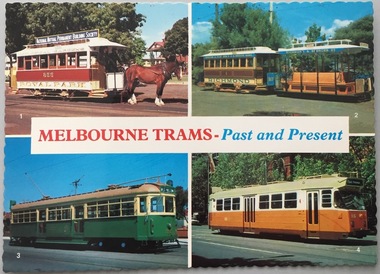
Postcard, The Tramway Museum Society of Victoria Ltd, Melbourne Trams: Past and Present, c.2000-2010
The Kew Historical Society's postcard collection includes views of Kew, Melbourne and Greater Melbourne as well as those including overseas scenes sent or received from Europe or the Middle East. They date from the 1890s to the 2000sPostcard produced for and retailed by The Tramway Museum Society of Victoria Ltd. The reverse of the postcard (see image) identifies the four trams pictured as: a Royal Park Horse tram, a Richmond cable tram, a W7 electric tram, and a Z3 class electric tram. The postcard was printed by scancolor Australia (03) 429 1477.1. Royal; Park horse tram 2. Richmond cable tram 3. W7 electric tram Photographs courtesy Melbourne and Metropolitan Tramways Board, K. Kings and R. Shorten [Producer] The Tramway Museum Society of Victoria Ltd Box Box 4916, Melbourne, Victoria, 3001 [Printer] scancolor Australia (03) 429 1477 CS 1482royal park horse tram, richmond cable tram, w7 electric tram, z3 class electric tram, the tramway museum society of victoria ltd, postcards -
 Kew Historical Society Inc
Postcard, The Tramway Museum Society of Victoria Ltd, Melbourne Trams: Past and Present, 2000-2010
The Kew Historical Society's postcard collection includes views of Kew, Melbourne and Greater Melbourne as well as those including overseas scenes sent or received from Europe or the Middle East. They date from the 1890s to the 2000s.Postcard produced for and retailed by The Tramway Museum Society of Victoria Ltd. The reverse of the postcard (see image) identifies the four trams pictured as: a Royal Park Horse tram, a Richmond cable tram, a W7 electric tram, and a Z3 class electric tram. The postcard was printed by scancolor Australia (03) 429 1477.1. Royal; Park horse tram 2. Richmond cable tram 3. W7 electric tram Photographs courtesy Melbourne and Metropolitan Tramways Board, K. Kings and R. Shorten [Producer] The Tramway Museum Society of Victoria Ltd Box Box 4916, Melbourne, Victoria, 3001 [Printer] scancolor Australia (03) 429 1477 CS 1482royal park horse tram, richmond cable tram, w7 electric tram, z3 class electric tram, the tramway museum society of victoria ltd, postcards -
Kew Historical Society Inc
Journal, Kew Historical Society, Newsletter No.111, June 2015
... . Kew Tram Depot / p7. Boroondara Remembers: Stories of World ...No 111 JUNE 2015. A historian's legacy (Dorothy Rogers) / Robert Baker p1. Exhibitions, Meetings & lectures, New members, 2015 meeting calendar / p3. What's in a box? / Suzanne McWha p5. New acquisitions / Robert Baker p5. A history of community activism / Valerie Bourke p6. Kew Tram Depot / p7. Boroondara Remembers: Stories of World War 1 / p7. Daily Life in Kew: the summer of 1885-86 / Andrew Frost p8. The textiles and clothing collection / Collections Activity Group p10. Kew Tram Depot celebrates 100 years / Tony Michael p11. Membership & Donations p12.Published quarterly since 1977, the newsletters of the Kew Historical Society contain significant research by members that explore aspects of the Victorian and Australian Framework of Historical Themes. Frequently, articles on people, places and artefacts are the only source of information about an aspect of Kew, and Melbourne’s history.non-fictionNo 111 JUNE 2015. A historian's legacy (Dorothy Rogers) / Robert Baker p1. Exhibitions, Meetings & lectures, New members, 2015 meeting calendar / p3. What's in a box? / Suzanne McWha p5. New acquisitions / Robert Baker p5. A history of community activism / Valerie Bourke p6. Kew Tram Depot / p7. Boroondara Remembers: Stories of World War 1 / p7. Daily Life in Kew: the summer of 1885-86 / Andrew Frost p8. The textiles and clothing collection / Collections Activity Group p10. Kew Tram Depot celebrates 100 years / Tony Michael p11. Membership & Donations p12. kew historical society (vic.) -- periodicals., kew historical society (vic.) -- newsletters, kew historical society (vic.) -- journals -
 Kew Historical Society Inc
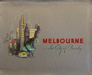
Booklet, Melbourne ... The City of Beauty, 1930s
Pictorial tourist folio of the City of Melbourne including black and white and colour photographsCover shows Collins Street with tram, Town Hall and Manchester Unity building. [24] p. : all ill. (some col.) ; 22 x 27 cmnon-fictionPictorial tourist folio of the City of Melbourne including black and white and colour photographsmelbourne (vic.) -- pictorial works, christian-washfold collection -
 Kew Historical Society Inc
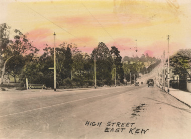
Postcard - High Street, East Kew, c.1927
... tram lines -- kew (vic.).... high street -- kew (vic.) Victoria park tram lines -- kew (vic ...High Street, Kew is the main Road in Kew. It was once also known as Bulleen Road, or Main Street. This section of the road is in Kew, although the narrow section on the right hand side of the photo is now Kew East. High Street progresses through a number of significant road junctions: beginning at Barkers Road; progressing through the intersection of Studley Park Road, Denmark Street and Princess Street at Kew Junction; branching left at the junction with Cotham Road; before reaching the junction with Valerie Street and Harp Road. It reaches its end at the junction of Burke Road, Kilby Road, Bulleen Road and High Street itself. An early photograph of this iconic Memorial that locates it in its context. Small, colorised real photo postcard of High Street, East Kew. Electric light poles line the road. Victoria Park is on the left and further on the horizon is the Boroondara General Cemetery.high street -- kew (vic.), victoria park, tram lines -- kew (vic.)