Showing 269 items matching "valley lake"
-
 Lakes Entrance Historical Society
Photograph, 1926 c
5003.2 Also a black and white photograph of distant view of Buchan Valley 05003.2 7 x 11.5 cmBlack and white photograph of a roadway scene showing early car and fence with water along road near Glenmaggie Victoriaroads and streets -
Southern Sherbrooke Historical Society Inc.
book, "Lysterfield Lake Park, Proposed Recreation Use Plan", Jun-86
A proposed plan for the recreational use of Lysterfield Lake Park.lysterfield lake park -
Southern Sherbrooke Historical Society Inc.
book, "Recreation Development Proposal, Lysterfield Lake Park", 1982
A submission by the National Parks Service for funding of the first stage of recreational development at Lysterfield Lake Park.lysterfield lake park -
Southern Sherbrooke Historical Society Inc.
Information folder - Belgrave Lake Park, 1990s
Folder containing items pertaining to history of Belgrave Lake Park. Contents:-|"Australian Platypus Conservancy. Platypus in Belgrave Lake Park" - summary of 1996 surveys, and general guidelines. Fax date 12 Feb 1998 -
Southern Sherbrooke Historical Society Inc.
Information folder - Lysterfield Lake Park, Nov-81
Folder containing information pertaining to Lysterfield Lake Park. Contents: -pamphlet, "Lysterfield Lake Park, A New Park For Melbourne", National Parks Service, dated November 1981 -
Southern Sherbrooke Historical Society Inc.
Minutes of the Lysterfield Lake Park Advisory Committee, 1980-1988, 1980-1988
Minutes created by Advisory Committee then donated to the society by Denise Tutt who was a community representative on the committee.An A3 folder containing minutes and supplementary documents for the Lysterfield Lake Park Advisory Committeelysterfield lake park, shire of sherbrooke, recreational facilities -
 Southern Sherbrooke Historical Society Inc.
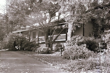
Photograph, Visit to Mt Heatherly, early 2000s
Photos of Mt Heatherly, an historical building in Belgrave, opposite Belgrave Lake Park. Address is Park Drive, on the corner of Waratah Ave. The house is now owned by Mrs Elizabeth Schneider, and was first constructed around 1881 by the first owner of the selection, Ormond Smith. It was made of hand-made bricks made on site, and a foundation of rock and stone. The original house may have had a corrugated iron roof. The original house forms part of the modern house. Photos taken in early 2000s by Susan Heywood-Downard. -
 Southern Sherbrooke Historical Society Inc.
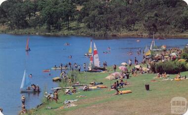
Postcard - Carinya postcard, boating on Aura Vale Lake
Colour Photograph of people boating at Aura Vale Lake. Several small sailboats are on the lake. People are also swimming and sunbathing. Several beach umbrellas have been set up on the grass. -
 Southern Sherbrooke Historical Society Inc.
Photograph - Belgrave Reservoir Easter 1922
B&W photo of Belgrave Reservoir, taken Easter 1922, presumably by Miss Field and passed on to Gwen Thomas then to Helen Gibson. Photo shows Belgrave Reservoir (now Belgrave Lake), possibly taken from near the weir and looking towards the heavily treed far shore. On back of photo, written in pen, is "Belgrave Res/Easter 1922'. 'Res' is slightly smudged and may have been 'Resv' or 'Resi'. -
 Southern Sherbrooke Historical Society Inc.
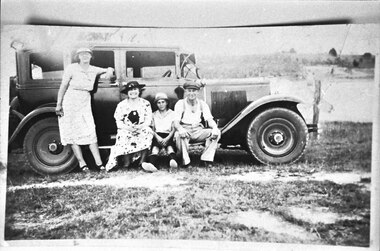
Photograph - Alice Slingo, Ann Lord, Bill Slingo Senior and Junior, posed with a Graham Paige car at Lysterfield lake
Photo of two women, a man and a boy posed in front of a Graham Paige car at Lysterfield Lake. This photo appears to have been taken on the same day as VSSHP0267.04 and was probably taken by Bill Lord. -
 Southern Sherbrooke Historical Society Inc.
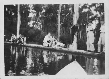
Photograph - People on the spillway of Belgrave Reservoir c.1940s
Black and white photo showing a group of people on the spillway of Belgrave Reservoir (at the time in the Belgrave Autocamp which is now called Belgrave Lake Park). The photo is taken from a person in a boat, the prow of which is visible at the bottom of the image. Three older boys are crouched to the left of the image. All are wearing shorts, shirts, and shoes with long socks, and two have pullovers. In the middle of the photo is a man with three children. The man is crouching. The children are in a huddle. To the right of the image are two adults standing on the spillway. The person on the right is male but the other's gender is uncertain. Between them and the children is what looks like a large portable radio. Behind the group is a heavily treed area which includes three or more white-trunked trees close to the spillway. In the distance is a white house with a verandah running across the front. This house belonged to Laura (surname unknown) before WW2. The house appears to be (now) 30 Judkins Ave.The photo has a white border and on the back is printed '1627'. It probably dates to the 1940s and is part of a collection of family photos donated by Pam Harris, Shire of Sherbrooke President, 1982-3 & 1987-1988. -
 Southern Sherbrooke Historical Society Inc.
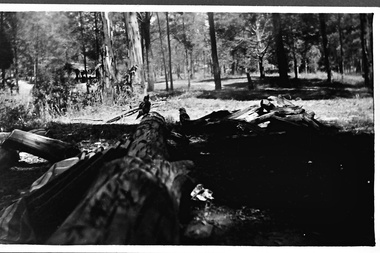
Photograph - Fairy Dell in Belgrave Lake Park c.1940s
Black and white photo taken at Fairy Dell in Belgrave Lake Park. There is felled timber in the foreground and what appears to be a plaid blanket lying to one side next to three or more long objects. Two kookaburras sit on the logs. In the background is a cleared area and a small covered eating area where some people are seated. On the back of the photo is printed '1920'. It probably dates to the 1940s and is part of a collection of family photos donated by Pam Harris, Shire of Sherbrooke President, 1982-1983 & 1987-1988. -
 Southern Sherbrooke Historical Society Inc.
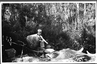
Photograph - Terry Smith at the building site of the caretaker's house, Belgrave Reservoir, c.1940s
Black and white photo of Terry Smith, Pam Harris's younger brother, aged about 6 or 7, during the building of a septic tank for the caretaker's house at Belgrave Lake Park. Terry is sitting in a concrete mixer. On the ground are bags of concrete. A pile of sand is on a tarpaulin. Behind Terry there are shrubs and small trees and behind them are tall trees on a steep hillside. The Belgrave Reservoir is at the bottom of the slope. A house can be seen in the distance, possibly the house visible in B0399. Terry and Pam's father, Oscar Smith, built the caretaker's house, selling it in 1960 for £1250. The photo probably dates to the 1940s and is part of a collection of family photos donated by Pam Harris, Shire of Sherbrooke President, 1982-1983 & 1987-1988. -
 Southern Sherbrooke Historical Society Inc.
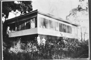
Photograph - Smith family holiday house on Park Drive, Belgrave, c.1940s
Black and white photo of the Smith family house on Park Drive just past Belgrave Lake Park. The House appears to have an enclosed verandah. A man, possibly Oscar Smith, is looking out of the window and a second person, possibly Pam Harris's sister, is also looking out. Below them, two young people, a boy and a smaller girl, are standing in the garden. This was possibly the caretaker's place. '1627' is stamped on the back of the photo. The photo probably dates to the 1940s and is part of a collection of family photos donated by Pam Harris, Shire of Sherbrooke President, 1982-1983 & 1987-1988. -
 Otway Districts Historical Society
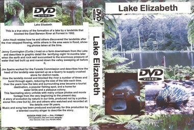
DVD, Lake Elizabeth, 2006
Lake Elizabeth was formed when a landslide slid into the valley damming the East Barwon River.Interviews with people who remember the formation of the Lake.30 Minute video of the creation of the lake in 1952lake elizabeth forrest east barwon -
 Bendigo Historical Society Inc.
Document - PETER ELLIS COLLECTION: PETER ELLIS EULOGY
2 A4 sheets. Handwritten pencil note at top of first page reads: Eulogy published in Trad & Now Magazine. Vale Peter Ellis OAM. By John Williams. The folk community lost a giant on May 18th when Peter Ellis passed away after a short illness. Peter had been a collector, author and musician for nearly forty years and his work has been prodigious to say the least. Peter has the largest collection of dance related material in the National Library and had travelled Australia on his collection trips. He produced twenty CDs of dance music and historical music with his Bendigo based band the Celebrated Emu Creek Bush Band which he founded and led for thirty four years. His final project was the double CD 'Cooee, Songs of the ANZACS' which he organised in conjunction with the Bendigo Historical Society. It was launched on 24th April and was Peter's last performance. Peter has also been a member of the Wedderburn Old Timers for over thirty years and has assisted with many of their recordings including their latest Bush Concert CD which Peter Organised. Peter has contributed to many other CDs over the years and has been thanked on many a CD cover by many folk artists. Peter has also written several books, the three volume 'Collectors' Choice,' 'Two Hundred Dancing Years' co-written with Shirley Andrews OAM, and 'Music Makes Me Smile' the history of the Nariel Valley musicians co-written with Harry Gardner. Peter's recent major work The Merry Country Dance will become the bible for people wishing to learn about our bush music heritage with its matching six CD collection. Peter has also contributed to 'Verandah Music' edited by Rob Willis and Graham Seal and 'The Oxford Companion to Australian Folklore' edited by Graham Seal and is a regular contributor to Trad & Now. He completed his last Trad & Now article the week before he died. Peter was also a life member of the Field Naturalists and was extremely active in campaigns to preserve Lake Pedder, the Whipstick Forest and Kamarooka Forest (now part of Bendigo National Park and preserved forever) One Tree Hill, Jackass Flat Flora Reserve and Saloman's Gully bushlands. Peter has discovered and named plants in the whipstick and enjoyed propagating native plants. He loved his amazing bush block in suburban Bendigo. Peter was also a keen photographer and had photos published in the book 'Wildflowers of Bendigo'. Peter taught dancing and music classes with Continuing Education for many years and encouraged many young musicians over the years. Peter was an accomplished ballroom dancer and had achieved gold medal status in that field. He was one of Australia's finest exponents of the button accordion, concertina, harmonica and tin whistle. Peter also played piano, organ and ukulele as well as the Swanee whistle and bones. Peter was the founder of the Annual Dinki Di Ball held each September in Eaglehawk as a tribute to the old MC's. Peter was happy playing for fund-raisers for any organisation who asked and also enjoyed plying the big gigs such as for the opening of the Melbourne Museum or for State Parliament. He played in the National Folk Festivals in four states and was a regular at the National in Canberra where he gave regular classes, performed with his bands and was a stalwart of the Aussie section of the session bar. He performed at nearly every Maldon Folk Festival and was MC at Nariel Folk Festival dances for many years. Peter was very proud of his OAM and wore the little medal at all of his performances. That honour was rightly given to one who did so much to preserve Australia's dance history. Peter lived a full life and was a friend to hundreds of people. He was taken far too young and in typical fashion was planning new projects right till the end. His passing is a huge loss for us all but one thing is certain. He will never be forgotten.person, individual, peter ellis oam -
 Bendigo Historical Society Inc.
Card - 25th Birthday Bush Trefoil Guild
The first meeting of the 1st Bendigo Guides was held by Miss Merle Bush on the 22nd of August 1922 in the St Paul' School Room. Twelve girls were present. Miss Bush was given permission to open the Company by Miss R. Hamilton, State Secretary for Victoria, she received her Captain's Warrant on 12th December 1922.Happy Birthday card - Colored scene of boats on a lake with building in the backgroundCongratulations and best wishes to the Merle Bush trefoil Guild on your 25th birthday ad all the best for your future. Happy Birthday. I am sorry that no one from Goulburn Valley Trefoil Guild can be with you today but I hope you have a wonderful day Beth Brisbane Goulburn Valley Trefoil Guildgirl guides, guiding, merle bush, trefoil guild, 25th birthday merle bush trefoil guild, goulburn valley trefoil guild -
 Kew Historical Society Inc
Postcard, R McGeehan, The Effect of Storm. Train Passing Through Flood Waters, South Yarra, 25-1-07, 1907
SHARP DOWNPOUR. ONE INCH IN 45 MINUTES. SOUTHERN SUBURBS DELUGED. TRAIN STOPPED AT SOUTH YARRA. One of the sudden downpours of rain which occasionally fall in Melbourne occurred yesterday afternoon, when nearly an inch of rain fell in the course of three quarters of an hour, and caused a flood for an hour or two in certain localities. During the early part of the day, the sky had been clouded over, but there was nothing to indicate a storm of such intensity as that which followed. At about half-past 1 o'clock residents of South Yarra, South Melbourne, Prahran, and St. Kilda noticed a few drops of rain. Still, it appeared unlikely that there would be anything exceptional, until with startling suddenness at about 10 minutes to 1 o'clock, one of the heaviest downpours within the memory of residents burst upon those suburbs. A strange feature of the storm was that it was practically confined to an area of about three miles square. The city was but little affected, though at a spot as close as the Observatory 86 points of rain were recorded in three-quarters of an hour. Thunder and lightning accompanied the downpour, which was cyclonic in character, the rain driving heavily from all points of the compass as the cyclone passed. It was in South Yarra and Prahran that the rain fell heaviest. Within a few minutes after it commenced, the low-lying portions of Toorak-road and practically the whole length of Chapel-street were under water. The depression at the intersection of Toorak-road and Darling-street speedily filled to the dimensions of a small lake. Several shops were inundated, while the water from the higher levels rushed down like a mountain torrent, and in several in-stances swept through the rear of houses and shops, carrying furniture in a floating mass against the further walls. In one case a footbridge was carried bodily away and dashed to pieces. Darling-street itself Great Davis-street, and other low-lying and flat thoroughfares in the vicinity became flooded from kerb to kerb, while on the other side of the railway-bridge the valley between Kensington-road and River-street became filled for some minutes to a depth of several feet. Meanwhile the waters from South Yarra hill, seeking a lower level, found it in the railway cutting, and the excavations from South Yarra station to Prahran on the one line, and to the Chapel-street bridge on the other, were converted into a couple of canals. At the platforms at South Yarra the water was two feet deep on the permanent way, and towards Hawksburn, at the sudden depression under Chapel-street bridge, it was at one time deep enough to cover a tall man's head. Into this swirling mass of water the 1:50 p.m. train from Oakleigh plunged on its way to Melbourne. The impact caused a mighty fountain of water to rise to a height of about 20 feet above the level of Chapel-street and send clouds of spray in all directions. Under the belief that a terrible explosion had occurred residents braved the rain and rushed to the spot, only to find that the train had been brought to a stand-still in the middle of what seemed to be a river. The water was so high that it had entered the fire-box from below, extinguishing the fires and cutting off the steam supply. In the meantime the officials at the South Yarra station had been preparing for emergencies. Inspectors were on duty at intervals along the line, and the moment the alarm was given an extra engine was backed carefully down and continued on to connect with the stranded train without losing its own power. There was a delay of about ten minutes in the service for an hour or two, but by 5 o'clock all the trains were running on time again, and the water had run off all but the spot beneath the Chapel-street bridge. Here the water remained about four feet deep until nightfall, and throughout the afternoon several hundreds of people including biograph operators and photographers, were gathered around watching each train pass through. Even with the water two feet lower, this was a work attended with considerable difficulty. Each train had to absolutely force its way through the weight of water, almost enveloped by the spray thrown up, and it was only just able to negotiate the "ford" by using every ounce of steam. ... The Argus, 26 January 1907, p19.The item forms part of the Laurie Bennett collection of thirty-six postcards and photographs of Kew and early Melbourne, donated to the Kew Historical Society in 1980. The postcards in the Bennett collection, like other images in the Society's holdings date from the 1890s to the present and comprehensively indicate points-of-view or scenes considered historically, aesthetically or socially significant in the period in which they were produced.Postcard depicting a flood at South Yarra Station in 1907. The title and photographer's name are identified on the front of the postcard. Donated by L. Bennett, 1980flood - south yarra, trains - melbourne, postcards, r mcgeehan - prahran -
 8th/13th Victorian Mounted Rifles Regimental Collection
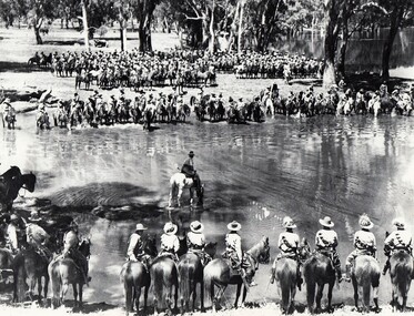
Photograph
A rare photograph of massed Light Horse in Victoria shortly before mechanisation consigned the horse to history.Black and white photograph of large group of horsemen in ranks waiting in the process of watering horses at a lagoon. One copy of the image claims it to be 8th Light Horse Regiment watering horses at a Murray River lagoon, South Corowa NSW, September 1939; Wahgunyah Troop, C Squadron - this side of lagoon, Lieutenant J. Nott on grey horse in water. A second copy (Cat No 0690) asserts it is 4 regiments of light horse being 8th, 13th, 20th and 4th watering horses near Torquay Victoria, March 1940.On a label on reverse of 0690: "Picture taken about March 1940 when the 13th Light Horse from Gippsland, the 8th Light Horse from Upper Murray, the 4th Light Horse from the Western Districts and the 20th Light Horse from the Goulburn Valley were in camp near Torquay. Mr Cappur Webb of Glendoxey, Seymour, a member of the 20th said the picture must have been taken during and exercise about five miles north of Torquay. “We used to water our horses in that lake”, he said." -
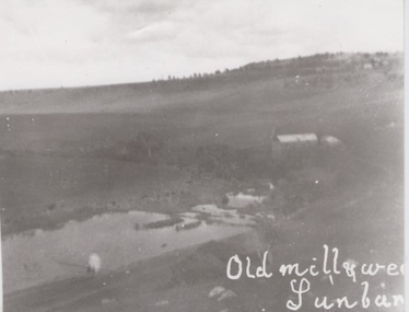 Sunbury Family History and Heritage Society Inc.
Photograph
... A black and white photograph of a building and a lake... and white photograph of a building and a lake in a valley. Buildings ...The former mill and weir shown in the photograph were sited on the banks of Jacksons Creek downstream from the town of Sunbury. John Eadie, a Scottish immigrant established the water-driven flour mill on the banks of the creek after he arrived in the colony in 1866. The mill continued operating until the outbreak of World War 1 when the metal wheel and iron roofing were taken and used for the war effort. The hill in the back ground with the trees and buildings was the site of the former Sunbury Asylum. Milling was one of Sunbury's early industries that were established in the district.A black and white photograph of a building and a lake in a valley. Buildings and trees are visible on a distant hillside.sunbury flour mill., milling -
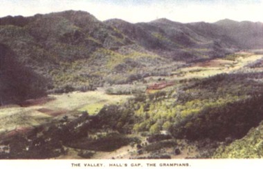 Stawell Historical Society Inc
Postcard, The Valley at Halls Gap with Lake Belfield & the Grampians -- Postcard -- Coloured
View of Halls Gap and Lake Belfield Grampiansstawell -
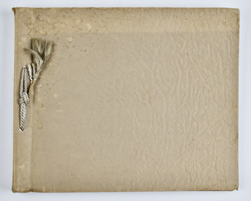 National Wool Museum
Album - Photo Album, 2 of 3, J W Allen, 1928-1929
This album is one of three albums compiled and owned by J W Allen, Secretary of New South Wales Grazier's, and is associated with the New South Wales Graziers Association world tour of sheep 1928-1929. This album contains photographs of travel, sheep, farms, stations, people and landscapes from around the world. Locations include Kenya, Kinangop, Naivasha, Elementeita, Lake Nakuru, Njoro, Namibia, Otjihavera, Mt Kenya, Isiolo, Yemen, Aden, Suez, River Jordan, Jerusalem, Hebron, Bethlehem, Beersheba, Galilee, Lake Tiberias, Mt Hermon, Canada, Mt Robson, Fraser River Canyon, British Columbia, Merrit, Canford, Alberta, Cardston, Pekisko Creek, Turner Valley, Calgary, Saskatoon, Manitoba, Winnipeg, Portage la Prairie, Niagara Falls, Quebec, Sainte-Anne-de-la-Pocatière and St Lawrence River. Properties depicted include Kenton Estates, Kekopey Ranch, Soysambu Ranch, Larmudiac, SX Ranch, Neilson's Ranch, EP Ranch and CX Ranch. The album was found in a clean out at the Great Southern Agricultural Research Institute and donated to the National Wool Museum, along with other related material such as photographs, glass lantern slides and ephemera.Photo album with card cover and silk string binding. Inside are twenty four pages of brown carded paper with black and white photos and hand written black text. A white piece of paper with hand written text has been added to the inside front page.new south wales graziers association, world tour, sheep, farm, rural, agriculture, ranch, travel, kenton estates, kekopey ranch, soysambu ranch, larmudiac, sx ranch, neilson's ranch, ep ranch, cx ranch, kenya, kinangop, naivasha, elementeita, lake nakuru, njoro, namibia, otjihavera, mt kenya, isiolo, yemen, aden, suez, river jordan, jerusalem, hebron, bethlehem, beersheba, galilee, lake tiberias, mt hermon, canada, mt robson, fraser river canyon, british columbia, merrit, canford, alberta, cardston, turner valley, pekisko creek, calgary, saskatoon, manitoba, winnipeg, portage la prairie, niagara falls, quebec, sainte-anne-de-la-pocatiere, st lawrence river -
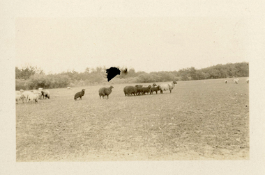 National Wool Museum
Photograph - Karakul Sheep, J W Allen, 1928-1929
This photograph was found loose in the second of three albums compiled and owned by J W Allen, Secretary of New South Wales Grazier's, and is associated with the New South Wales Graziers Association world tour of sheep 1928-1929. The album contains photographs of travel, sheep, farms, stations, people and landscapes from around the world. Locations include Kenya, Kinangop, Naivasha, Elementeita, Lake Nakuru, Njoro, Namibia, Otjihavera, Mt Kenya, Isiolo, Yemen, Aden, Suez, River Jordan, Jerusalem, Hebron, Bethlehem, Beersheba, Galilee, Lake Tiberias, Mt Hermon, Canada, Mt Robson, Fraser River Canyon, British Columbia, Merrit, Canford, Alberta, Cardston, Pekisko Creek, Turner Valley, Calgary, Saskatoon, Manitoba, Winnipeg, Portage la Prairie, Niagara Falls, Quebec, Sainte-Anne-de-la-Pocatière and St Lawrence River. Properties depicted include Kenton Estates, Kekopey Ranch, Soysambu Ranch, Larmudiac, SX Ranch, Neilson's Ranch, EP Ranch and CX Ranch. The album was found in a clean out at the Great Southern Agricultural Research Institute and donated to the National Wool Museum, along with other related material such as photographs, glass lantern slides and ephemera.Black and white image showing sheep in a paddock.world tour, sheep, graziers, photograph, karakul, winnipeg, canada, manitoba, agriculture -
 National Wool Museum
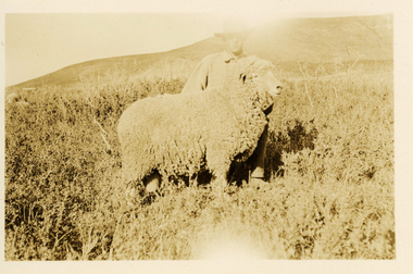
Photograph - 'Harvey' Ram at Neilson's Ranch, J W Allen, 1928-1929
This photograph was found loose in the second of three albums compiled and owned by J W Allen, Secretary of New South Wales Grazier's, and is associated with the New South Wales Graziers Association world tour of sheep 1928-1929. The album contains photographs of travel, sheep, farms, stations, people and landscapes from around the world. Locations include Kenya, Kinangop, Naivasha, Elementeita, Lake Nakuru, Njoro, Namibia, Otjihavera, Mt Kenya, Isiolo, Yemen, Aden, Suez, River Jordan, Jerusalem, Hebron, Bethlehem, Beersheba, Galilee, Lake Tiberias, Mt Hermon, Canada, Mt Robson, Fraser River Canyon, British Columbia, Merrit, Canford, Alberta, Cardston, Pekisko Creek, Turner Valley, Calgary, Saskatoon, Manitoba, Winnipeg, Portage la Prairie, Niagara Falls, Quebec, Sainte-Anne-de-la-Pocatière and St Lawrence River. Properties depicted include Kenton Estates, Kekopey Ranch, Soysambu Ranch, Larmudiac, SX Ranch, Neilson's Ranch, EP Ranch and CX Ranch. The album was found in a clean out at the Great Southern Agricultural Research Institute and donated to the National Wool Museum, along with other related material such as photographs, glass lantern slides and ephemera.Black and white image showing a man and a sheep in the foreground with mountains in the background.Back: [handwritten] Harvey ram / at Neilson’s / Harvey / Neilson’s ranch [printed] A 40world tour, sheep, graziers, photograph, canada, agriculture, cardtson, alberta -
 National Wool Museum
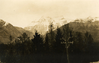
Photograph - Mount Robson, J W Allen, 1928-1929
This photograph was found loose in the second of three albums compiled and owned by J W Allen, Secretary of New South Wales Grazier's, and is associated with the New South Wales Graziers Association world tour of sheep 1928-1929. The album contains photographs of travel, sheep, farms, stations, people and landscapes from around the world. Locations include Kenya, Kinangop, Naivasha, Elementeita, Lake Nakuru, Njoro, Namibia, Otjihavera, Mt Kenya, Isiolo, Yemen, Aden, Suez, River Jordan, Jerusalem, Hebron, Bethlehem, Beersheba, Galilee, Lake Tiberias, Mt Hermon, Canada, Mt Robson, Fraser River Canyon, British Columbia, Merrit, Canford, Alberta, Cardston, Pekisko Creek, Turner Valley, Calgary, Saskatoon, Manitoba, Winnipeg, Portage la Prairie, Niagara Falls, Quebec, Sainte-Anne-de-la-Pocatière and St Lawrence River. Properties depicted include Kenton Estates, Kekopey Ranch, Soysambu Ranch, Larmudiac, SX Ranch, Neilson's Ranch, EP Ranch and CX Ranch. The album was found in a clean out at the Great Southern Agricultural Research Institute and donated to the National Wool Museum, along with other related material such as photographs, glass lantern slides and ephemera.Black and white image showing trees, power pole and power lines in the foreground and snow covered mountains in the background. world tour, sheep, graziers, photograph, canada, agriculture, british columbia, mount robson, mt robson -
 Vision Australia
Photograph (item) - Image, Ballarat plaques
Kelaston (Ballarat Day Centre) was furnished with donations from Ballarat and surrounding districts. To acknowledge this generosity, plaques were created and placed in various locations around the centre. The inscriptions read as follows: This room was refurbished through the assistance of the Ballarat Police and Patrons Golf Club -1989- Generous gifts donated in memory of Cecil H. Jeffrey and George R. Rose furnished this area This room was furnished by Buningyong Auxiliary -1957- These facilities were made possible through the support of Mr Z. Nelsons This room was furnished by Lismore Auxiliary 1957 This room was sponsored by Wendouree Younger Set for the Aged Blind This room was furnished by Snake Valley/Carngham Auxiliary This room was furnished by Mrs Philip Russell Carngham 1959 This room was furnished by Hamilton Auxiliary 1957 Presented by Lorraine Bennett -1951- This room was furnished by the Bungaree Auxiliary Sponsored by Brown Hill Auxiliary 1963 This room was furnished by the Ballarat Bowling Club This lounge room was furnished by the late Miss J.A. Wright through her bequest to the Ballarat Ladies Auxiliary This room was furnished by Snake Valley/Carngham Auxiliary 1959 This room was furnished by Penhurst Auxiliary 1957 This room was furnished by Wendouree Auxiliary 1958 The generous gift of Wendouree Mills furnished this room This room was furnished by Wendouree Auxiliary This room was furnished by Lismore Auxiliary 1957 This room was furnished by Mortlake Auxiliary 1957 This room was furnished by Lake Bolac Auxiliary 1958 This room was furnished by Camperdown Auxiliary 1957 This room was furnished by Staff of Allied Bruce Small 1958 This room was furnished by Buninyong Auxiliary 1957 This room was furnished by the ladies of the Ballarat Philharmonic Singers This room was furnished by Waubra AuxiliaryVariouskelaston, auxiliaries, fundraising, plaques -
 Federation University Art Collection
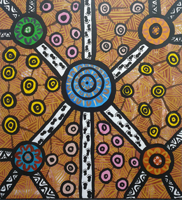
Painting, Ronald Edwards-Pepper, 2020
Ronald EDWARDS PEPPER Gunai Ronald Edwards Pepper is the grandson of Dulcie (Dolly) Mullet and Watson Pepper, Ronald’s family moved to Morwell in the 1960s from Lake Tyers Mission. He graduated from Federation University with a Bachelor of Visual and Media Arts in 2017, and has completed several commissions and participated in numerous exhibitions, in Australia and overseas. Artist Ronald Edwards-Pepper is keen to express himself through painting and telling stories of his Gunai/Kurnai ancestors. "My nanna and her stories have been part of my life, and who I have become today, and this influences my artworks. My grand-parents are Dolly Mullet & Watson Pepper. They came from Lake Tyers Mission and moved to Morwell in the 1960s with their mob of kids. Now this is the family home." EDUCATION: 2013-2017 - Bachelor of Visual & Media Arts/Federation University. 2010 - Trainee Mentor in Education (Latrobe Regional Gallery, Morwell) 2008 - Certificate III in Aboriginal Torres Strait Islander in Languages 2007 - Traineeships, Young Ambassador at the Latrobe Regional Gallery, Morwell 2006 - Completed & Graduated - Awarded 'Student of the Year’ 2005 - Certificate IV ATSI Cultural Arts, TAFE Mid-valley Campus Gippsland 2003 - Certificate 4 in Aboriginal and Torres Strait lslander Art & Design, TAFE Mid-valley Campus, Gippsland 2002 - Certificate 3 in Aboriginal and Torres Strait Islander Art & Design, TAFE Mid-valley Campus, Gippsland AboriginalSigned verso "R.Edwards"ronald edwards, aboriginal, gunai kurnai -
 Falls Creek Historical Society
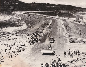
Photograph - Building Rocky Valley Dam Wall
The Rocky Valley Dam is located on the Bogong High Plains, near Falls Creek, Victoria. The dam is man-made and has a capacity of 28,000 megalitres (990×106 cu ft). At an elevation of 1600m, Rocky Valley Dam is the highest significant body of water in Australia. The dam was created for the Kiewa Hydroelectric Scheme. Just a short distance from the heart of the village, the lake provides a playground for a range of aquatic activities. It is also utilised in snow making for the Falls Creek ski resort. Work began on the Rocky Valley Dam site in early 1947 and continued until May. It resumed in October after the winter and a camp for the accommodation of workmen was commenced at this time. Work continued in 1948 with the establishment of work facilities, including the erection of two large excavators. The Rocky Valley Dam was completed in 1959.These images are significant as they capture work carried out to build the wall at Rocky Valley near Falls Creek, VictoriaThree black and white images showing work on the Rocky Valley Dam, Victoriarocky valley dam, kiewa hydroelectric scheme, falls creek -
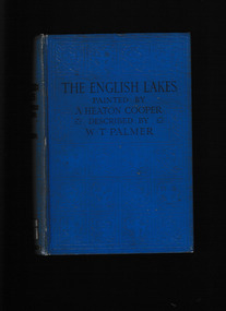 Mrs Aeneas Gunn Memorial Library
Book, A. and C. Black, The English lakes, 1925
A description of the English lakesIndex, ill, map, p.230.non-fictionA description of the English lakes english lakes - description, english lakes - travel -
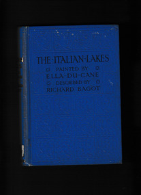 Mrs Aeneas Gunn Memorial Library
Book, A & C Black, The Italian lakes, 1925
A travellers guide to the Italian lakesIll, p.195.A travellers guide to the Italian lakesitaly - lakes, italy - description and travel