Showing 237 items
matching water engineering
-
 Wodonga & District Historical Society Inc
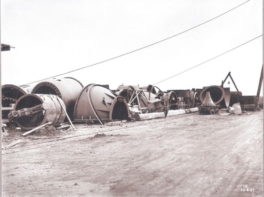
Album - Hume Reservoir Australia Album - Needle valves, August 1927
This set of photos is from a leather bound album bearing the inscription "HUME RESERVOIR AUSTRALIA" plus 'The Rt. Hon. L. C. M. S. Amery, P. C., M .P.' all inscribed in gold. It was presented to The Rt. Hon. L. C. M. S. Amery, P. C., M. P, Secretary of State for Dominion Affairs on the occasion of his visit to the Hume Reservoir on 2nd November 1927. This album is of local and national significance as it documents the planning and development of the Hume Reservoir up to 1927. It was the largest water reservoir in the British Empire. The album records the pioneering engineering work that went into its construction.DEPARTMENT OF PUBLIC WORKS, N.S.W. RIVER MURRAY WATERS SCHEME. HUME RESERVOIR. 34. Needle Valves. Some of the needle valves in parts stacked ready for removal by the cableway to their positions on the outlets. There are seven of these, 7 feet 6 inches in diameter. The heaviest single part weighs about 10 tons. New South Wales. August 1927. A needle valve is a type of valve which can be used to regulate flow of a substance, usually either gas or water, through an appliance or system. The unique feature of the value is the inclusion of a small plunger, with a shape akin to a needle.hume reservoir australia, river murray waters scheme, hume reservoir construction -
 Wodonga & District Historical Society Inc
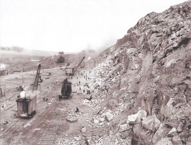
Album - Hume Reservoir Australia Album - View along the face of the quarry, August 1927
This set of photos is from a leather bound album bearing the inscription "HUME RESERVOIR AUSTRALIA" plus 'The Rt. Hon. L. C. M. S. Amery, P. C., M .P.' all inscribed in gold. It was presented to The Rt. Hon. L. C. M. S. Amery, P. C., M. P, Secretary of State for Dominion Affairs on the occasion of his visit to the Hume Reservoir on 2nd November 1927. This album is of local and national significance as it documents the planning and development of the Hume Reservoir up to 1927. It was the largest water reservoir in the British Empire. The album records the pioneering engineering work that went into its construction.DEPARTMENT OF PUBLIC WORKS, N.S.W. RIVER MURRAY WATERS SCHEME. HUME RESERVOIR. 35. Quarry. View along the face of the quarry. Granite is being quarried here for the concrete material. Blocks from 2-8 tons in weight are reserved for “plums”. Quantities of large size spalls are sent to Victoria for the toe of the embankment and other purposes but the greatest proportion of the stone is crushed at the quarry to 2½ inches gauge for concrete aggregate. Two steam navvies and two steam travelling cranes are at work on the face. New South Wales. August 1927.hume reservoir australia, river murray waters scheme, hume reservoir construction -
 Wodonga & District Historical Society Inc
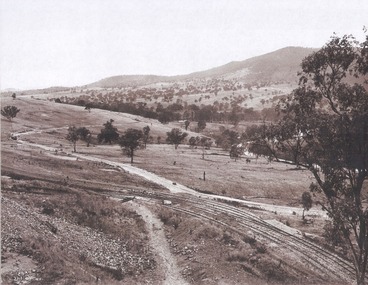
Album - Hume Reservoir Australia Album - Valley of the Murray to be crossed by the Bethanga Bridge 1927
This set of photos is from a leather bound album bearing the inscription "HUME RESERVOIR AUSTRALIA" plus 'The Rt. Hon. L. C. M. S. Amery, P. C., M .P.' all inscribed in gold. It was presented to The Rt. Hon. L. C. M. S. Amery, P. C., M. P, Secretary of State for Dominion Affairs on the occasion of his visit to the Hume Reservoir on 2nd November 1927. This album is of local and national significance as it documents the planning and development of the Hume Reservoir up to 1927. It was the largest water reservoir in the British Empire. The album records the pioneering engineering work that went into its construction.DEPARTMENT OF PUBLIC WORKS, N.S.W. RIVER MURRAY WATERS SCHEME. HUME RESERVOIR. 36. Valley of the Murray to be crossed by the Bethanga Bridge described in the next photograph. (WHS 00731) This view shows the marshalling sidings for trucks below the Quarry, New South Wales, and the branch line to the site of the bridge.hume reservoir australia, river murray waters scheme, hume reservoir construction -
 Wodonga & District Historical Society Inc
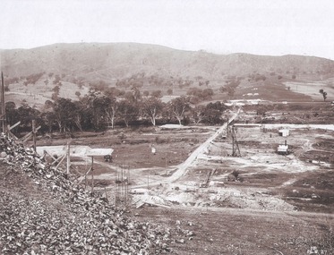
Album - Hume Reservoir Australia Album - Bethanga Bridge Site, August 1927
This set of photos is from a leather bound album bearing the inscription "HUME RESERVOIR AUSTRALIA" plus 'The Rt. Hon. L. C. M. S. Amery, P. C., M .P.' all inscribed in gold. It was presented to The Rt. Hon. L. C. M. S. Amery, P. C., M. P, Secretary of State for Dominion Affairs on the occasion of his visit to the Hume Reservoir on 2nd November 1927. This album is of local and national significance as it documents the planning and development of the Hume Reservoir up to 1927. It was the largest water reservoir in the British Empire. The album records the pioneering engineering work that went into its construction.DEPARTMENT OF PUBLIC WORKS, N.S.W. RIVER MURRAY WATERS SCHEME. HUME RESERVOIR. 37. Bethanga Bridge Site. A bridge is being built to cross the Reservoir to serve a large area of country which will be cut off from its natural outlets by the submergence of existing bridges when the Reservoir is in being. The site of the bridge is nearly a mile up the Murray from the Hume Reservoir Quarry. Its length will be approximately half a mile. There will be nine spans of 269 feet with steel truss girders resting on concrete pillars. Some of the pillars are founded on rock while others will rest on nests of reinforced concrete piles. The foundations and concrete piers are in the hands of the Victorian Constructing Authority and the superstructure in those of the New South Wales Authority. August 1927.hume reservoir australia, river murray waters scheme, hume reservoir construction -
 Wodonga & District Historical Society Inc
Photograph - Bethanga Bridge
The Bethanga Bridge was built between 1927 and 1930 as a joint venture between Victoria and New South Wales and was a key element of the River Murray Waters Agreement. It consists of nine spans of 82 metres long. Each span is supported between double reinforced concrete pylons and a riveted steel camel back Pratt truss. The overall span of the bridge is a length of 752 metres. It was completed in 1929 at a cost of £194,000. The road deck was initially constructed from timber but was replaced in 1961 with a concrete waffle slab deck 7.7metres wide. In 1961 the bridge deck and truss structure were raised 300 millimetres to allow for the enlargement of the lake. The bridge was designed in NSW by road engineer Percy Alan and the trusses were built by the Charles Ruwolt Pty. Ltd. Charles Ruwolt Pty. Ltd. was originally established by Charles Ruwolt as a foundry at Wangaratta in 1902 and transferred its operations to Richmond, Melbourne in 1914. By 1938 it had become one of the biggest engineering companies in Australia. After Charles Ruwolt’s death in 1946, Vickers Ltd. acquired the company and in 1948 the firm became known as Vickers Ruwolt Pty. Ltd. Because of the Bethanga Bridge’s unique location, over the waters of a dam with the border running down the centre of the body of water, the Bethanga Bridge is the only built structure shared by both Victoria and New South Wales. As the border of New South Wales aligns with the southern bank of the Murray River all of the other bridges along its length are deemed to be in New South Wales. The Bethanga Bridge is listed on both the New South Wales State Heritage Register and the Victorian Heritage Database. In 2015 the Bethanga Bridge was nominated for a heritage award by the Institution of Engineering Australia.These images are significant because they document the construction of a bridge which links Victoria and New South Wales and has been recognised for its historical, technical and engineering significance.A collection of photos documenting the construction of the Bethanga Bridge which links the States of Victoria and New South Wales as part of the construction of the Hume Dam .bethanga bridge, hume dam constuction, charles ruwolt, percy allan engineer -
 Wodonga & District Historical Society Inc
Functional object - Water Pump Pressure Gauges, North East Region Water Authority, Wodonga
The water pump pressure gauges were used by the Wodonga Waterworks Trust and Sewerage Authority, which were established in 1897, and had the responsibility for providing Wodonga's drinking water and managing the wastewater. In 1923 a Wodonga Waterworks Trust referendum to provide funding for new infrastructure to supply more water of better quality to Wodonga was passed. This included building the Wodonga Water Tower and it was completed in 1924. It supplied water to Wodonga until 1959, when it was drained and decommissioned after the No 1 Basin on Huon Hill was completed in 1958. In 1983 the Wodonga Waterworks Trust and the Wodonga Sewerage Authority became part of the Wodonga Council. By 1989 a filtration plant at Huon Hill was completed, which provided filtered water of improved quality to Wodonga, in accordance with the World Health Organisation’s guidelines. In 1994 the Kiewa Murray Region Water Authority took over the Wodonga Council’s water and wastewater operations, and then in 1999 the Kiewa Murray Region Water Authority combined with the Ovens Region Water Authority and became the North East Region Water Authority or NERWA. NERWA then became known as North East Water.The water pump pressure gauges have local significance due to their use by the Wodonga Waterworks Trust and Sewerage Authority, and donation from the North East Region Water Authority. They also have wider historical significance as examples of the equipment used in the management of water in Victoria and Australia.Five metal and glass water pump pressure gauges, including one with a U-shaped pipe and lever attached. "-HOMPSONS (CASTLEMAINE) LT-" on pressure gauge no.1 "BOURDON'S / PRESSURE GAUGE / THE AUSTRAL OTIS /ENGINEERING Co. LD. / MELBOURNE" on pressure gauge no.2 "No. 1609 / POUNDS PRESSURE / PER SQ. INCH / FEET HEAD OF WATER" on pressure gauge no. 3 "FEET HEAD OF WATER / THOMPSONS (CASTLEMAI-- LTD" on pressure gauge no. 4 "SET SLOW 33' -" / BUDENBERG / MADE IN AUSTRALIA / ft water / 1 4 9 3 9 each number underlined" on pressure gauge no. 5north east region water authority, nerwa, wodonga sewerage authority, north east water, n.e. water, wodonga waterworks trust, pressure gauges, water pump pressure gauges -
 Eltham District Historical Society Inc
Photograph - Digital Photograph, Alan King, Maroondah Aqueduct Siphon Bridge over the Plenty River, 26 January 2008
Opened in 1891, the bridge formed part of the Maroondah Aqueduct carrying water from Watts River near Healesville to the reservoir at Preston where it joined Melbourne's metropolitan water system. Covered under Heritage Overlay, Nillumbik Planning Scheme. Published: Nillumbik Now and Then / Marguerite Marshall 2008; photographs Alan King with Marguerite Marshall.; p99 Built to supply thirsty Melbourne in the late 19th century, the siphon bridge spanning the Plenty River off Leischa Court, Greensborough, was part of an engineering masterpiece. Opened in 1891, the bridge formed part of the Maroondah Aqueduct carrying water from the Watts River near Healesville to the reservoir at Preston where it joined the metropolitan distribution system. A major link in Melbourne’s water supply, it also had a huge impact on communities, which mushroomed along its route. Named after the Aboriginal word for the area around the Maroondah Reservoir, the Maroondah Aqueduct was fully operational until the 1970s. Since the 1980s the land along parts of the aqueduct have been used for walking and bicycle riding, shaded in places by Monterey Pine trees planted to stabilise the surrounding ground. From 1857 the Yan Yean Reservoir supplied Melbourne’s water but the growing city needed additional catchments.1 In 1886 work began on a weir on the Watts River to enable the aqueduct to carry most of the river water 41 miles (66km) to Melbourne. The aqueduct, built by the Board of Works, is the oldest remaining aqueduct near Melbourne and was probably the first built with concrete.2 Although the aqueduct is now only used between the Maroondah and Sugarloaf Reservoirs, it can still be traced across the Shire. It extends from the Maroondah Reservoir through Christmas Hills, Kangaroo Ground, Research, Eltham, St Helena and then previously wound west through Greensborough to Reservoir.3 Built by horse and manpower the aqueduct gravity fed 25 million gallons (113.6ML) of water a day to Melbourne along a gradient of one foot to the mile. It included 25 miles (41km) of open concrete and brick channel, six miles (10km) of tunnels, and nine miles (15km) of 14 inverted siphons of riveted wrought-iron across creeks. Bricks for the aqueduct were made from clay found near the sites and remains of several kilns can still be found between Kangaroo Ground and Christmas Hills. Building the aqueduct transformed local communities. An abattoir was established at Christmas Hills. Grog shanties and labourers’ camps sprang up and local courts dealt with cases of ‘petty pilfering and boisterous behaviour’.4 The Kangaroo Ground school population jumped to 91, crammed into a room with one teacher. Miners who built the tunnels camped just north of Churinga in Greensborough – then called Tunnel Hill Camp – and adjacent to the Evelyn Arms Hotel. The miners’ high spirits were sometimes quenched in horse troughs or by a ‘welt under the ear and kick on the behind’ as the local constable calmed them down rather than lock them up.5 But the growing city of Melbourne needed more water, so the O’Shannassy catchment, east of Warburton, was added to the system in 1914. In 1920 work began on the present concrete Maroondah Dam one mile (1.6km) from the weir on the Watts River. The aqueduct capacity was thus doubled to 50 million gallons (227ML) a day.6 Intense land development threatened to pollute the open water supply, so channel sections were replaced with large pipes. In the late 1960s a large water main was built from the tunnel outlet at Research and extended through St Helena and Greensborough, so this section of the aqueduct was taken out of use. Long sections of the unused open channels in Greensborough and Bundoora were destroyed, but the old channel in Research and Eltham North remained largely intact. In the 1970s, the Sugarloaf Reservoir was constructed, inundating 445 hectares of land in Christmas Hills. Sugarloaf was officially opened in 1980 and serves as a water storage and treatment plant supplying Melbourne. In the early 1980s pipes replaced the section from Sugarloaf Reservoir to the tunnel entrance at Kangaroo Ground. The Research-Kangaroo Ground tunnel operates as part of the pipeline system.This collection of almost 130 photos about places and people within the Shire of Nillumbik, an urban and rural municipality in Melbourne's north, contributes to an understanding of the history of the Shire. Published in 2008 immediately prior to the Black Saturday bushfires of February 7, 2009, it documents sites that were impacted, and in some cases destroyed by the fires. It includes photographs taken especially for the publication, creating a unique time capsule representing the Shire in the early 21st century. It remains the most recent comprehenesive publication devoted to the Shire's history connecting local residents to the past. nillumbik now and then (marshall-king) collection, maroondah aqueduct, pipe bridge, siphon bridge -
 Eltham District Historical Society Inc
Photograph - Digital Photograph, Marguerite Marshall, Smith Dam, Karingal Drive, Eltham, 19 September 2006
The dam at the entrance to the Nerreman Gateway in Eltham was built according to an internationally acclaimed theory developed by the builder's father. In 1920, Victorian engineer B.A. Smith was awarded the American Society of Civil Engineers J. James R. Cross Gold Medal for his Technical Paper titled 'Arched Dams'. It was the first time this medal had been awarded outside the United States. The concrete arched dam across the Eltham West Drain was built in 1940 by B.A. Smith's son and engineer, D. B. (Bernie) Smith to water the 24 acre (9.75 ha) hobby farm owned by himself and new wife, Isa Smith. Upon completion of the dam a pump-house was constructed beside the creek but before the water could be pumped up the hill they had to dig a trench and lay 500m of 100mm water main to an elevated holding tank. The Smiths made the pump-house their home for several years until they constructed their home at the top of the hill overlooking Eltham and views extending to Kinglake. Following Bernie's death in 1983, Nerreman Park was subdivided between 1993 and 1995. Gordon Ford designed the landscaping and the pump-house was demolished. Covered under Heritage Overlay, Nillumbik Planning Scheme. Published: Nillumbik Now and Then / Marguerite Marshall 2008; photographs Alan King with Marguerite Marshall.; p137 The dam at the entrance to the Nerreman Gateway in Eltham, was built according to an internationally acclaimed theory developed by the builder’s father. In 1920, Victorian engineer B A Smith was awarded the American Society of Civil Engineers J. James R. Croes Gold Medal, for his Technical Paper titled Arched Dams. It was the first time this medal had been awarded outside America. An international example of the application of Smith’s work can be found in the design of the Hoover Dam on the Colorado River, Nevada, USA. Built between 1930 and 1936, it is recognised by the ASCE as one of ‘America’s Seven Modern Civil Engineering Wonders’.1 The concrete arched dam across the Eltham West Drain was built by B A Smith’s son and engineer, D B (Bernie) Smith. Bernie’s dam followed his father’s theory, having a curvature that takes maximum advantage of concrete’s great strength in compression. The water load is carried into the abutments because of this curvature, which permits a wall thickness of only 225 millimetres thick at its crest, despite the dam’s capacity of more than 4.5 megalitres. The Eltham dam was designed to water the 24 acre (9.75 ha) hobby farm belonging to newly married couple Bernie and Isa Smith. Bernie, from Armadale, and Isa, from a farm at Tyntynder near Swan Hill, were attracted to the hilly topography and the creek running through the property. It extended from Ryans Road, Eltham, to Karingal Drive, Montmorency and was adjacent to Meruka Park. The Smiths named it Nerreman Park using the Aboriginal word Nerreman meaning ‘River Bend’ as their creek had a pronounced bend.2 In 1940 the first thing Bernie did was to build a dam, and with Isa’s help, a pump-house, to secure a water supply for their cattle, pigs, chickens, orchard and vegetable gardens. It was also available for the fire-plugs, which they placed all over the property in case of bushfire. The couple built the pump-house beside the creek and installed a Tange three-plunger pump, which had originally supplied the City of Wodonga with water. But before the Smiths could pump water up the hill from the dam they had to dig a trench and lay about 550 yards (500m) of a four-inch (100mm) water main up to an elevated holding tank. The trench was dug with a single furrow plough drawn by an old draught horse. Living in rough conditions did not deter the Smiths, who made the pump-house their home, where they still lived when their first child was born in 1944. They later built their home at the top of their property overlooking Eltham, with magnificent views to Kinglake, the Dandenong Ranges and Melbourne. From 1946 it took them almost 20 years to complete the 36-square house with its 12-foot (3.6m) high ceilings. Material for the concrete roof and walls faced with sandstone, was ripped out of the ground on their property by plough pulled by tandem Clydesdale horses. Isa was a strong woman – two days before their second child was born – she set three huge sandstone boulders in place in the bottom wall of the garage. She also mixed all the cement for the house. A collapsed kitchen wall did not discourage her from rebuilding it in a week, while her husband was away working in the country. She later recalled: ‘We stood back to admire this beautiful wall we’d built and while we were looking at it, it came tumbling down’.3 Following Bernie’s death in 1983, Nerreman Park was subdivided, between 1993 and 1995. Local Gordon Ford designed the landscaping and the pump-house was pulled down. But the dam remains as a reminder of exceptional engineering4 – and of a remarkable couple.This collection of almost 130 photos about places and people within the Shire of Nillumbik, an urban and rural municipality in Melbourne's north, contributes to an understanding of the history of the Shire. Published in 2008 immediately prior to the Black Saturday bushfires of February 7, 2009, it documents sites that were impacted, and in some cases destroyed by the fires. It includes photographs taken especially for the publication, creating a unique time capsule representing the Shire in the early 21st century. It remains the most recent comprehenesive publication devoted to the Shire's history connecting local residents to the past. nillumbik now and then (marshall-king) collection, eltham, karingal drive, smiths dam, bernie smith, gordon ford, isa smith, nerreman gateway, nerreman park estate, dams -
 Stawell Historical Society Inc
Book - Stawell Water Supply, Gary Vines, Engineering Heritage Recognition Ceremony Stawell Water Supply Sunday 12 October 2014, 2004
... Engineering Heritage Recognition Ceremony Stawell Water Supply Sunday ...Booklet with glossy paper in colour: Ceremony:Hosted By:Engineers Australia;Engineering Heritage Victoria; Engineers Australia Wimmera Regional Group;Institute Of Public Works Engineers Australasia;Notrthern Grampians Shire Council;GWM Water stawell -
 Flagstaff Hill Maritime Museum and Village
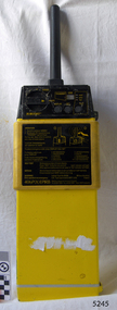
Equipment - EPIRB Transmitter
This distress EPIRB unit (Emergency Position Indication Radio Beacon) was found on the beach at Levy's Point, Warrnambool, in December 2000 by a Warrnambool resident. Local police were alerted at the time. This distress signal unit is a world-wide COSPAS/SARSAT, satellite assisted, SAR (Search and Rescue) system for location of distress transmissions emitted by an EPIRB. Offshore cruising vessels must have such a unit as part of its essential safety equipment. This model EPIRB relies on four satellites with orbit times of approximately 100 minutes. Earlier units relied solely on aircraft flying overhead to detect and forward on the EPIRB’s location to Search And Rescue authorities, whereas this new system utilises satellites. An employee from the Lokata firm provided additional information about the Lokata EPIRB units. They had a machined aluminium case with labels that were also made on site. The units could be activated manually or automatically released when a magnetic switch in the case casing was activated. This later model, circa 1983, would have been mounted externally on a vessel's bulkhead in a spring-loaded, stainless-steel protective 'skeleton' mounting, The unit released when the water pressure sensor detected a set time it was under the water, in a similar way that life crafts were released. Each unit was registered to a particular vessel - the vessel's details on this unit are indecipherable. The Lokata Company was established in 1970, designing and manufacturing marine products including communications. The company no longer makes products with the “Lokata” brand. In 2001 Sartech Engineering Ltd. took over the support for the Lokata EPIRB beacons. This emergency location device is a late 20th century invention to help save lives at sea. It adds to the history of maritime life, its risks, the lives lost as sea, and the many inventions aimed as rescuing and saving lives. The local area is notorious for the number of lives lost through shipwreck. It also carries stories of heroic efforts to save lives, and other inventions to help reduce the chance of accidents at sea.EPIRB unit; “Emergency Position Indication Radio Beacon”. A distress communication unit for sending a distress location transmission in an emergency at sea. The EPIRB is a yellow, rectangular box with dials, buttons, indicator lights and instruction. An antenna protrudes from the top of the unit. The EPIRB unit sends a 406P (X) EPIRB, with 406M-Hz frequency, 48-hour duration signal. The maker was LOKATA Ltd in England. Remnants of a white label remain on the side. Circa 1980s."NAME OF VESSEL 'SERVICE IF SELF TEST FAILS' " “LO-KATA” moulded into the body. "406P (X) EPIRB" “Model 406” "Lokata Type No 92408" "UK Type approved to MPT 1278" "Class 2" "Made by Lokata Ltd, Falmouth Cornwall England TR10 8AE"" "LOKATE LTD. New North Road Hainault, Ilford Essex IG6 2UR" "ARMED / SAFE / TRANSMIT / CODE / DISPLAY / SET / wait / pass / fail / TEST" "IDENTIFIER / 1349:24034234N" [some characters may be different] "COUNTRY / DENMARK" "VESSEL IDENTITY / 124 [the rest is indecipherable]flagstaff hill, warrnambool, shipwrecked-coast, flagstaff-hill, flagstaff-hill-maritime-museum, maritime-museum, shipwreck-coast, flagstaff-hill-maritime-village, emergency position indicating radio beacon, epirb, lokata ltd, marine safety equipment, satellite transmitting beacon, safety equipment, distress signal, life saving, safety at sea, shipwreck location, lo-kata, falmouth, emergency, beacon, radio signal, communication, marine equipment -
 National Vietnam Veterans Museum (NVVM)
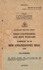
Booklet, Australian Army, Australian Army: Field Engineering And Mine Warfare, Pamphlet No. 10: Mine Anti-personnel M18A1 (Claymore), 1970
A blue coloured back cover with the front cover which has rutned to a brownish colour with some blue at the bottom of the cover and it looks like possible water marks on the cardboard cover. Top right hand side reads DSN 7610-66-034-5750. There are two punch holes down the left hand side of the booklet.australia - armed forces - service manuals, australina military forces, field engineering, mine warfare, mine "anit-personnell m18a1, claymore mine -
 Bendigo Historical Society Inc.
Document - BENDIGO FOUNDRIES
Typed notes on Bendigo Foundaries. Notes mention some of the foundries that were in Bendigo, the work they did, where they were, and where some of their work can be seen.document, bendigo foundaries, horwood & sons, girton college, the victoria foundary, andrew harkness & co, palmer river diggings, george lansell, robert harkness, abraham roberts, united iron works, laanecoorie weir, bendigo railway station, coles new world supermarket, target stores, taylor horsefield's engineering works, improved harvester, hugh victor mckay, holland bros., state rivers & water supply, civic buildings, st aiden's, bendigo hospital, carter & brown, osborn bros, bendigo building society, a'becket chambers, fortuna, george lansell, lansell mine, army survey regiment, jorgenson's, st killian's fence, redpath & brown -
 Melbourne Tram Museum
Document - Folder with papers, Folder of memos and directions, c1940
Folder of Memos and directions (htd3207i1> htd3207i8) - Air raid precautions, covering painting, respirators, sheds, tools, kits, shelters, stacks , blackouts, trenches, emergency, air raid shelters (htd3207i9> htd3207i16) - Accidents, covering accidents and derailments, (htd3207i17) - Bridges – inspection of Victoria St bridge (htd3207i18) - Cable tracks, covering tarring, patching, top dressing of cable tracks (htd3207i19> htd3207i21) - Cartage, covering hired trucks, cartage of wood blocks, spoil, sleepers (htd3207i22> htd3207i23) - Contracts, blank page (no image) - Councils, covering track opening, storm water drain, bad roads (htd3207i24) - Costs, covering maintenance costs, construction costs, wet weather (htd3207i25> htd3207i26) - Depots, covering inspections, storage, paving, telephones, mail (htd3207i27> htd3207i30) - Derailments, covering controls, reports (htd3207i31) - Drainage (htd3207i32) - Eastern Lines, covering loading platforms, crossovers, work orders (htd3207i33> htd3207i34) - Eastern Lines Reconstruction (htd3207i35> htd3207i37) - Eastern Line Maintenance (htd3207i38> htd3207i40) - Estimates (htd3207i41) - Employment (htd3207i42) - Footscray Lines (htd3207i43) - Instructions (htd3207i44) - Journals, covering Engineering Journal and magazines (htd3207i45) - Materials – General, covering frames & covers, unloading stores, packing plates, petrol allowance, ashes at Preston workshops, electrodes, sleepers (htd3207i46> htd3207i50) - Maintenance – General, covering loading platforms, inspections, work orders, paving (htd3207i51> htd3207i57) - Northern Lines, covering greasing of curves, crossovers, loading platforms (htd3207i58> htd3207i61) - Northern Lines – Reconstruction, covering crossings, welding machines (htd3207i62> htd3207i64) - Northern Lines – Maintenance, covering repairs, crossings, lifting programme, fencing, curves, track inspection, repairs (htd3207i65> htd3207i70) - New Lines (htd3207i71> htd3207i80) - Plant – General (htd3207i81> htd3207i94) - Plant – Concrete Mixers (htd3207i95) - Plant – Motor Vehicles (htd3207i96> htd3207i100) - Plant – Rollers (htd3207i101> htd3207i103) - Plant – Grinders (htd3207i104) - Plant – Grinders & Scrubbers (htd3207i105> htd3207i110) - Plant – Compressors and Tie Tampers (htd3207i111) - Plant – Cleaner Cars (htd3207i112> htd3207i114) - Plant – Loaders (htd3207i115) - Plant – Tools (htd3207i116> htd3207i117) - Plant – Miscellaneous (htd3207i118) - Per Way – General (htd3207i119> htd3207i121) - Public Utilities (htd3207i122> htd3207i123) - Reconstruction – General (htd3207i124> htd3207i126) - Railways (htd3207i127> htd3207i129) See \dbtext\hawthorn\photo_collections\3207_Folder for scanned images.trams, tramways, instructions -
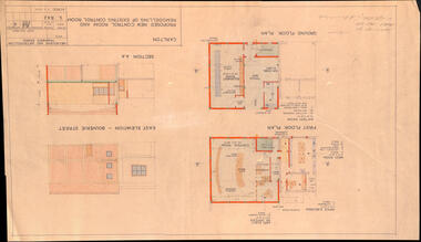 Melbourne Tram Museum
Drawing, Melbourne & Metropolitan Tramways Board (MMTB), "Carlton - Proposed new control room and remodelling of existing control room", May. 1961
Drawing - titled - "Carlton - Proposed new control room and remodelling of existing control room", coloured with a water colour brush, showing the proposed extensions to the Carlton control room, drawing Number S842, dated 9-5-1961. Shows the ground and first floors, mess room, offices, stairs and control room layout. Has the external elevations and sections.Has some pencil notations front and back re lights and sketch.trams, tramways, carlton, control centre, power supply, electrical engineering, electrical switching -
 Bendigo Historical Society Inc.
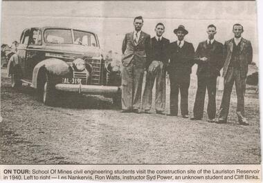
Newspaper - JENNY FOLEY COLLECTION: ON TOUR
Work started on the Lauriston Reservoir in 1939 as part of the Coliban water system and was officially opened by Victorian Premier, Albert Dunstan in 1941. Capacity was increased in 1946 when steel spillway gates were added. Although these had been part of the original design they could not be added at the time of the building because of post-war steel shortages.Bendigo Advertiser ''The way we were'' from 2003. on tour: school of mines civil engineering students visit the construction site of the Lauriston Reservoir in 1940. Left to right: Les Nankervis, Ron Watts, instructor Syd Power, an unknown student and Cliff Binks. The clip is in a folder.newspaper, bendigo advertiser, the way we were -
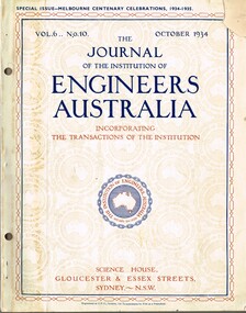 Melbourne Tram Museum
Magazine, Engineers Australia, Journal of the Institution of Engineers Australia" - Vol 6, No. 10, Oct. 1934, "Metropolitan and Provincial Tramways", Oct. 1934
Journal or magazine - stapled pages approx. 100 printed on semi gloss paper, with glue outside cover, titled Journal of the Institution of Engineers Australia" - Vol 6, No. 10, Oct. 1934 - Special issue - Melbourne Centenary Celebrations 1934 - 1935. Contains transactions of radio frequency, institution and related activities, and 100 years of Engineering in Victoria. These include maps of Victoria and Melbourne, Engineering Education (Kernot), Metropolitan Roads and Bridges by J. Noble Anderson City Engineer of Richmond, Country Roads and Bridges, Railway Development (VR), Metropolitan and Provincial Tramways (Strickland and Russell), Port of Melbourne, Outer ports, air transport, water supply, sewerage and drainage, gas industry, electricity supply, communications (telephone and telegraph), industrial development and mining. Has ads for British Insulated cables, Thompsons Engineer, Goodyear, GEC - British General Electric, Associated General electric, Vickers and many other companies. Photocopy of article from the Bob Lilburn collection.trams, tramways, centenary, victoria, tramways, railways, secv, mmtb, cable trams -
Moorabbin Air Museum
Book - Aeronautical Engineering, Pracical Analyutical Geometry With Application to Aircraft
Study of the application of analytical geometry to a practical mathematical definition of aircraft contours & structures, circa 1944First few pages slightly water damagednon-fictionStudy of the application of analytical geometry to a practical mathematical definition of aircraft contours & structures, circa 1944 -
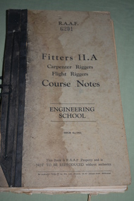 Wangaratta RSL Sub Branch
Manual - R.A.A.F. Fitters Manual II.A, c1942
Item issued to 20164 Granville Inverell Hamilton BULLUSS Born 12/11/1909 in Hamilton NSW . He enlisted at Tamworth into the RAAF. Service records not available to the public.RAAF Fitters Manual II.A belonging to 20164 Cpt Bulluss G. Book has black binding with black cord to bind it. Cover is a dirty cream colour with black writing. Water stain on front cover.R.A.A.F. 6201 Fitters II.A Carpenter Riggers, Flight Riggers, Course Notes, Engineering School. Issue 4 - 1942. This book is R.A.A.F Property and is NOT TO BE REPRODUCED without authority. Inside cover written in red ink is 20164 Cpt Bulluss G.raaf, manual, world war 2 -
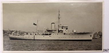 Flagstaff Hill Maritime Museum and Village
Photograph - Vessel, Steam Ship, H.M.A.S. Warrnambool J202, 1941-1947
This photograph is connected to the first HMAS Warrnambool J202, which was commissioned by the Royal Australian Navy for use as a minesweeper during World War II. The Bathurst Class Corvette, fitted out with a range of armaments, was launched in Sydney 1941. The ship began service in Bass Strait in 1941. At the end of the year it called into its namesake city, Warrnambool, where the crew paraded for the public marching eastwards along Timor Street. A gift of books for the ship’s personnel and a plaque bearing the City of Warrnambool’s Coat of Arms were presented to the ship. The ship was involved in evacuating a family of nine from the Dutch East Indies that was later successful in its challenge of Australia’s Immigration Restriction Act (White Australia Polity). The ship had many other appointments around Australia. On 13th September 1947 HMAS Warrnambool was leading a flotilla of minesweepers in northern Queensland’s coastal waters, clearing mines previously laid to defend Australia. The ship hit a mine, which exploded and very quickly sunk the ship. Boats from the nearby ships rescued most of the seamen although one was killed at the time. The survivors were taken by the HMAS Swan II to Darwin, and they went from there to hospitals in Brisbane and Sydney. Three of these men later died from their injuries. A number of items were recovered by Navy divers in 1948 including the ship’s bell and a plaque with Warrnambool’s Coat of Arms. In 1972-75 the wreck was sold and other items were salvaged. In 1995 a memorial plaque was erected in Warrnambool near the RSL. NOTE: The RAN built a second HMAS Warrnambool FCPB204, launched in 1981 and decommissioned in 2005. There was also a steam ship SS Warrnambool built in London 1892 and broken up in 1926. [A more detailed history can be found in our Collection Record 3477.] This photograph is significant for its association with Royal Australian Navy and its vessel, HMAS Warrnambool (j202). The HMAS Warrnambool played a nationally significant role in overturning Australia’s Immigration Restriction Act 1901 (colloquially known as the White Australia policy). The ship rescued, and brought to Australia, Samuel and Annie Jacob and their family after they evacuated Dutch East India. The family was threatened with deportation and made the first successful appeal to High Court regarding that Act. The HMAS Warrnambool has - Local significance for being the namesake of the City of Warrnambool - Local significance, having docked in Warrnambool Harbour - Local significance, the crew having paraded in Timor Street, Warrnambool - State significance for its first patrol being in Bass Strait. - National significance, being present in Timor at the Japanese surrender - National significance as part of Australia’s defence force history, being one of only four Bathurst class corvettes lost while in Australian service, the only Bathurst class corvette lost after World War II, the only RAN vessel to be sunk by a mine, and associated with the last four Navy deaths of WWIIPhotograph, black and white, HMAS Warrnambool J202 in water with land and buildings in background. Ship is flying a dark flag with Union Jack in corner and star below it. Lifeboat suspended above deck in centre of ship. Top of funnel has a black band. flagstaff hill, warrnambool, shipwrecked-coast, flagstaff-hill, flagstaff-hill-maritime-museum, maritime-museum, shipwreck-coast, flagstaff-hill-maritime-village, maritime village, maritime museum, shipwreck coast, mort's dock & engineering co ltd, h.m.a.s. warrnambool, hmas warrnambool, hmas warrnambool i, hmas warrnambool j202, hmas swan ii, j202, world war ii, bathurst class corvette, royal australian navy, ran, sydney built ship, bass strait patrol, sea mine patrol, mine sweeper, mine clearance, navy divers, great barrier reef, cockburn reef, southern cross diving and salvage, warrnambool city council, cr j r astbury, mayor j r astbury, warrnambool patriotic fund, seal, coat of arms, ship’s bell, hmas warrnambool 1941, shipwreck by sea mine 1947, sinking ship, sunk ship, sea rescue, life saving, lifesaving, minesweeper -
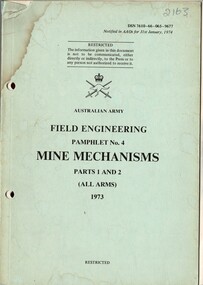 National Vietnam Veterans Museum (NVVM)
Booklet, Australian Army, Australian Army: Field Engineering Pamphlet No. 4: Mine Mechanisms, Parts 1 and 2 (All Arms) 1973, 1973
A faded blue coloured cardboard cover with black information on the front. Top right hand side reads DSN 7610-66-065-9677. Under the Australian Army insigia are the details of the booklet. There are several pages that have become loose from the booklet. there is what appears to be a water stain on the top left hand corner and there are two holes down the left hand side.australia - armed forces - service manuals, field engineering, mine mechanisms -
 Lakes Entrance Historical Society
Photograph - Snowy Mountains Hydro Electric Scheme c1950, Jack Palmer, 1950 c
... Government Civil Engineering Topography Water Resources ...Black and white photograph taken at sign for Snowy Mountains Hydro Electric Scheme in Australian Alps. Also five other black and white photographs taken at Snowy Mountain project 6 x 8.5 cm government, civil engineering, topography, water resources -
 Narre Warren and District Family History Group
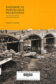
Book, RD La Nauze, Engineer to marvellous Melbourne, 2011
"Engineer to Marvellous Melbourne provides a compelling account of the evolution of Melbourne's water and sewerage systems and the life and achievements of a great Australian engineer who, in triumphing over difficulties, left an enduring impact on Melbourne." -- Publisher website.xiv, 217 p.; 24 cmnon-fiction"Engineer to Marvellous Melbourne provides a compelling account of the evolution of Melbourne's water and sewerage systems and the life and achievements of a great Australian engineer who, in triumphing over difficulties, left an enduring impact on Melbourne." -- Publisher website. sewerage, sanitary engineering -
 Lakes Entrance Historical Society
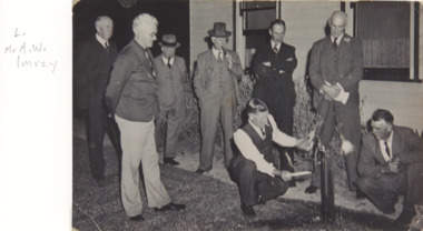
Photograph, SA Oil Wells Company Lakes Entrance Victoria, 1930
Black and white photograph showing eight men around a tap, man kneeling appears to be lighting gas associated with underground water from a drill site, on left Mr AW Imray Director of SA Oil Wells Company Lakes Entrance Victoriaoil and gas industry, engineering, social history -
 Lakes Entrance Historical Society
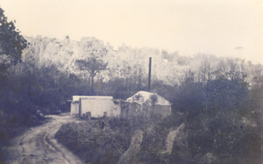
Photograph, Oil dehydration plant, Lakes Entrance Victoria, 1930 c
Oil water emulsion was fed into concrete vats where up to 95 percent of water was drained off plant situated at end of track to Midwest No 1 boreBlack and white photograph showing the dehydration plant which separated the oil from original emulsion sityuated in the gully east of Capes Road off Myer Street Lakes Entrance Victoriaoil and gas industry, engineering, social -
 Lakes Entrance Historical Society
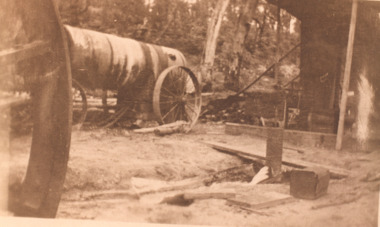
Photograph, Abandoned oil well Lakes Entrance, 1930 c
Sepia toned photograph of water flowing from abandoned oil well Lakes Entrance Development Company drilled in 1924 at Lake Bunga Victoriaengineering, oil drilling, oil and gas industry -
Port Melbourne Historical & Preservation Society
Photograph - Esplanade East Pumpimg Station, David RADCLIFFE, January 2025
Taken at the Esplanade East Pumping Station during the Open Day held by Melbourne Water on the 26th January 2025 engineering - board of works, pumping station -
Port Melbourne Historical & Preservation Society
Photograph - Esplanade East Pumpimg Station, David RADCLIFFE, January 2025
Taken at the Esplanade East Pumping Station during the Open Day held by Melbourne Water on the 26th January 2025 engineering - board of works, pumping station