Showing 1450 items matching "water victoria"
-
 Flagstaff Hill Maritime Museum and Village
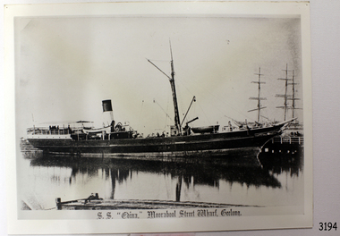
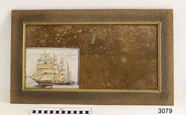
Photograph, S.S. "EDINA," Moorabool Street Wharf, Geelong, c. 1870's - 1930's
This black and white photograph was taken when the SS Edina was as port at the Gellong Wharf in Moorabool Street. The Port of Geelong had many wool sheds alongside the wharf - wool was a major export product. ABOUT THE S S EDINA The three masted iron screw steamer SS Edina was built in Glasgow, Scotland, in 1854 by Barclay and Curle. She was adorned with the figurehead of ‘fair maid of Judea’. The many years of service made SS Edina famous world-wide as the longest serving screw steamer. (The term screw steamer comes from being driven by a single propeller, sometimes called a screw, driven by a steam engine.) SS Edina’s interesting history includes English Chanel runs, serving in the Crimean Ware carrying ammunition, horses and stores to the Black Sea, and further service in the American Civil War and later, serving in the western district of Victoria as well as in Queensland and carried gold, currency and gold prospectors Australia to New Zealand. SS Edina had the privilege of being an escort vessel to H.R.H. the Duke of Edinburgh during his visit to Australia in 1867. In March 1863 SS Edina arrived in Port Phillip Bay, Melbourne and was bought by Stephen Henty, of Portland fame, to work the cargo and passenger run from Melbourne – Warrnambool – Port Fairy - Portland. After a short time of working the run from Australia to New Zealand, with passengers and cargo that included gold and currency, she returned to her Melbourne - Warrnambool – Port Fairy run, with cargo including bales of wool produced in the western district of Victoria. The Warrnambool Steam Packet Company purchased SS Edina in 1867; she was now commanded by Captain John Thompson and Chief Engineer John Davies. She survived several mishaps at sea, had a complete service and overhaul and several changes of commanders. In 1870 SS Edina was in Lady Bay, Warrnambool, when a gale sprung up and caused a collision with the iron screw steamer SS Dandenong. SS Edina’s figurehead was broken into pieces and it was not ever replaced. SS Edina was re-fitted in 1870 then was used as a coastal trader in Queensland for a period. She was then brought to Melbourne to carry cargo and passengers between Melbourne and Geelong and performed this service 1880-1938. During this time (1917) she was again refitted with a new mast, funnel, bridge and promenade deck, altering her appearance. In 1938, after more collisions, SS Edina was taken out of service. However she was later renamed Dinah and used as a ‘lighter’ (a vessel without engine or superstructure) to be towed and carry wool and general cargo between Melbourne and Geelong. In 1957, after 104 years, the SS Edina was broken up at Footscray, Melbourne. Remains of SS Edina’s hull can be found in the Maribyrnong River, Port Phillip Bay. [Reference: A Brief Review of Steam Navigation in Victoria; C Dickson Gregory; Centenary Maritime Exhibition catalogue, 1934; published by Shiplovers' Society of Victoria Dandenong, Passengers in History, http://passengersinhistory.sa.gov.au/node/924034 Edina, Victorian Heritage Database VHR S199 http://vhd.heritage.vic.gov.au/shipwrecks/heritage/199 SS Edina, Coastal Trader and Passenger Ship 1853-1938, Museum Victoria Collections, https://collections.museumvictoria.com.au/articles/6227 SS ‘Edina’ – the Longest Serving Screw Steamer in the World, POI Australia, https://poi-australia.com.au/ss-edina-the-longest-serving-steamer-in-the-world/ ]This postcard of the SS Edina is significant for its association with the screw steamer SS Edina and shows her at one of her trading ports on the Melbourne - Warrnambool - Port Fairy - Portland run. The SS Edina is heritage listed on the Victorian Heritage Database VHR S199. She had endeared herself to the people of Port Phillip Bay as a passenger ferry, part of their history and culture. She played a significant role in the Crimean War, the American Civil War and the gold rush in New Zealand. She also served western Victoria for many years in her cargo and passenger runs. The SS Edina is famous for being the longest serving screw steamer in the world. After spending her first nine years overseas she arrived in Melbourne and her work included running the essential service of transporting cargo and passengers between Melbourne and the western Victoria ports of Warrnambool, Port Fairy and Portland. The SS Edina was purchased in the late 1860’s by local Warrnambool business, the Warrnambool Steam Packet Co. and continued trading from there as part of the local business community. The SS Edina’s original ‘fair maid of Judea’ figurehead was broken to pieces in a collision with another vessel (the SS Dandenong) in a gale off Warrnambool, Victoria, in 1870.Black and White photograph of S.S Edina at the Moorabool Street Wharf, Geelong in calm water that shows the reflection of the steamer. Ship has no sails raised. The funnel has a light coloured base with a dark coloured top. There are people on board the steamer. Other ship masts and people are in the background. In the foreground is a jetty with a small boat beside it and a person inside the boat. There is a title printed along the base of the photograph. c. 1870's to 1930'sPrinted at base of photograph "S.S. "EDINA," Moorabool Street Wharf, Geelong"warrnambool, shipwrecked coast, flagstaff hill, flagstaff hill maritime museum, maritime museum, shipwreck coast, flagstaff hill maritime village, shipwrecked artefact, barclay & curle, figurehead 'fair maid of judea', centenary maritime exhibition 1934, a brief review of steam navigation in victoria, pleasure steamer edina, trade and travel late 19th and early 20th century, trade melbourne to geelong, screw steamer edina, coastal trader edina, lighter dinah, cargo carrying for cremean war, cargo carrying for american civil war, passenger and trade in western district of victoria, export gold and currency and gold diggers to new zealand, export vessel to h r h the duke of edinburgh, melbourne - warrnambool - port fairy - portland cargo run, warrnambool steam packet company, stephen henty, captain john thompson, chief engineer john davies, lady bay warrnambool, lighter edina, shipping victoria, port phillip bay steamers, steamship great britain, edina, vhr s199 victorian heritage database, postcard of ss edina 1870's - 1930's -
 Flagstaff Hill Maritime Museum and Village
Glass
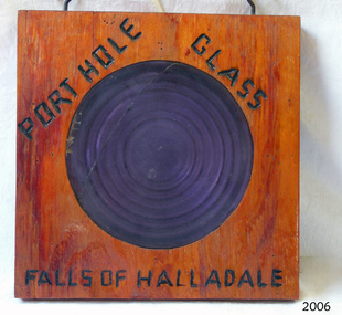
Falls of Halladale The Falls of Halladale was a four-masted sailing ship built-in 1886 in Glasgow, Scotland, for the long-distance cargo trade and was mostly used for Pacific grain trade. She had a sturdy construction built to carry maximum cargo and able to maintain full sail in heavy gales, one of the last of the ‘windjammers’ that sailed the Trade Route. She was one of the first vessels to include fore and aft lifting bridges, which kept the crew safe and dry in as they moved around the decks in stormy conditions. She was owned by Wright, Breakenridge & Co of Glasgow and was one of several Falls Line ships, all of which were named after waterfalls in Scotland. On 4th August 1908, with new sails, 29 crew, and 2800 tons of cargo, the Falls of Halladale left New York, bound for Melbourne and Sydney via the Cape of Good Hope. The cargo on board was valued at £35,000 and included 56,763 tiles of American slate roofing tiles, 5,673 coils of barbed wire, 600 stoves, 500 sewing machines, 6,500 gallons of oil, 14,400 gallons of benzene, plumbing iron, 117 cases of crockery and glassware and many other manufactured items. The Falls of Halladale had been at sail for 102 days when, at 3 am on the of 14th November 1908, under full sail in calm seas with a six knots breeze behind and misleading fog along the coast, the great vessel rose upon an ocean swell and settled on top of a submerged reef near Peterborough on south-west Victoria’s coast. The ship was jammed on the rocks and began filling with water. The crew launched the two lifeboats and all 29 crew landed safely on the beach over 4 miles away at the Bay of Islands. The postmistress at Peterborough, who kept a watch for vessels in distress, saw the stranding and sent out an alert to the local people. A rescue party went to the aid of the sailors and the Port Campbell rocket crew was dispatched, but the crew had all managed to reach shore safely by the time help arrived. The ship stayed in full sail on the rocky shelf for nearly two months, attracting hundreds of sightseers who watched her slowly disintegrate until the pounding seas and dynamiting by salvagers finally broke her back, and her remains disappeared back into deeper water. The valuable cargo was largely lost, despite two salvage attempts in 1908-09 and 1910. Further salvage operations were made from 1974-1986, during which time 22,000 slate tiles were recovered with the help of 14 oil drums to float them, plus personal artefacts, ship fittings, reams of paper and other items (a list of items held at Flagstaff Hill Maritime Village is included below). The Court of Marine Inquiry in Melbourne ruled that the foundering of the ship was entirely due to Captain David Wood Thomson’s navigational error, not too technical failure of the Clyde-built ship. The shipwreck is a popular site for divers, about 300m offshore and in 3 – 15m of water. Some of the original cargo can be seen at the site, including pieces of roof slate and coils of barbed wire. The Falls of Halladale shipwreck is listed on the Victorian Heritage Register (No. S255). She was one of the last ships to sail the Trade Routes. She is one of the first vessels to have fore and aft lifting bridges. She is an example of the remains of an International Cargo Ship and also represents aspects of Victoria’s shipping industry. The wreck is protected as a Historic Shipwreck under the Commonwealth Historic Shipwrecks Act (1976).Porthole glass secured in wood, with a crack in the glass. Writing on wood "porthole Glass Falls of Halladale."Burnt into the wood are the words "porthole Glass Falls of Halladale."falls of halladale, wright, breakenridge & co of glasgow, californian blue roof slate, warrnambool, shipwrecked-coast, flagstaff-hill, flagstaff-hill-maritime-museum, maritime-museum, shipwreck-coast, flagstaff-hill-maritime-village, shipwrecked-artefact, porthole glass -
 Flagstaff Hill Maritime Museum and Village
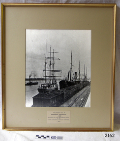
Photograph - Ships, South Warrnambool Primary School Centenary Committee, Unloading coal at Warrnambool Breakwater, 1977
This photograph was framed and mounted then presented to the South Warrnambool school by the South Warrnambool Centenary Committee in 1977 on the school's centenary year. The school was decommissioned and closed in the 1990s. In the photograph, people unload the coal from the ship beside the Breakwater and load it into the row of tramway carts. The coal would be sold to businesses and householders for the purpose of fuel for warmth, cooking, heating water and running machinery. The image shows the early days at the Port of Warrnambool. The building of the Warrnambool Breakwater had only just been completed. Steamships and sailing ships were frequent visitors to the port. Steam Navigation companies were plentiful, carrying passengers and freighting cargo such as coal, timber, food, livestock, furniture, hardware and haberdashery between Melbourne and the ports along the southwest coast of Victoria, including Warrnambool. The carts would take their loads into the township for distribution. The ship carrying the coal is thought to be the "S.S. Chillagoe" previously named "Speculant". In 1903 the Chillagoe was registered at the Port of Melbourne, and it sailed between Melbourne and Newcastle, New South Wales, where coal was mined and sold in significant quantities. In March 1890 a tragedy occurred when coal was being unloaded at the Warrnambool Breakwater. A local young man, David Ferrier, was working in the hold of the steamship Kurrara as its delivery of coal was being unloaded. A basket of coal fell from a sling onboard and came down upon Ferrier, breaking his back. He was not expected to live. In September 1890 there was a strike of coal workers but the Geelong Advertiser reported that a Warrnambool firm of coal merchants had recently received some large cargoes from Newcastle.The photograph is historically significant as it is connected with the local areas of the Warrnambool Breakwater, Lady Bay, and the South Warrnambool Primary School. The scene shows a moment in time when a steamship was unloading a shipment of coal onto tram carts on the Breakwater, which had only just been completed that year. The photograph was taken about 13 years after the opening of the South Warrnambool School, which was decommissioned around 20 years after it celebrated its centenary.. Photograph, black and white, in a gilded rectangular wooden frame, behind glass. The maritime scene shows figures on ships beside the Warrnambool Breakwater jetty and figures on the jetty, standing next to rail carts containing coal. There is a steamship further out on Lady Bay. A card below the photograph has an inscription and there is a pencil inscription on the back of the frame. The coal ship is thought to be the SS. Chillagoe. The photograph was taken in 1890 and was presented to the South Warrnambool School in its centenary year, 1977, by the South Warrnambool Centenary Committee.Typewritten on card: "UNLOADING COAL AT WARRNAMBOOL BREAKWATER"- 1890 - "Presented to Sough Warrnambool School by the SOUTH WARRNAMBOOL CENTENARY COMMITTEE - 1977 - " Handwritten in pencil on the back:"Speculant" as "SS Chillagoe" at Breakwater"flagstaff hill, warrnambool, maritime museum, maritime village, great ocean road, shipwreck coast, warrnambool breakwater, 1890, tramway, steamship, sailing ship, coal, cargo, port of warrnambool, unloading coal, chillagoe, speculant, newcastle, kurrana, david ferrier, coal strike -
 Ringwood and District Historical Society
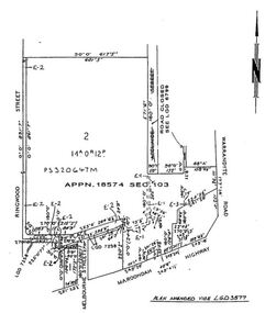
Document - Folder, Commercial and Retail Property Sales Information, Civic Place and Melbourne Street, Ringwood - 1998
45 photocopied pages including - Plan of Subdivision No.LP80718, Parish of Ringwood, Victoria, Crown Portion 12(Part) and part of a former government road Ref Vol 8668 Fol 745. - Vendors Statement, Planning Certificate and Heritage Council (Victoria) Certificate issued for 20 Melbourne Street, Ringwood. - Maroondah City Council Land Information Certificate for 149 149A and 149B Maroondah Highway; number 8 Civic Mall; and numbers 16, 20, 22 & 24 Melbourne Street Mall. - Yarra Valley Water statements relating to encumbrances for Shop 11, 149 Maroondah Highway; Shop 10, 149A Maroondah Highway; Shop 9, 149B Maroondah Highway; numer 8 Civic Place; Unit 3, 20 Melbourne Street; Office 4, 20 Melbourne Street; Shop 7, 22 Melbourne Street; and Shop 8, 24 Melbourne Street. - Land Tax Certificate pertaining to Commonwealth Bank, Civic Place, Ringwood. - Certificate of Title Vol 8892 Fol 906, Lot One on Plan of Subdivision No. 80718, Parish of Ringwood - Hanover Developments P/L - 29th June, 1971. -
 Flagstaff Hill Maritime Museum and Village
Decorative object - Wall Hanging, c. 1908
The unusual beautiful green American slate roofing tile used in this wall hanging was recovered from the shipwrecked Falls of Halladale. The iron-hulled, four-masted barque, the Falls of Halladale, was a bulk carrier of general cargo. She left New York in August 1908 on her way to Melbourne and Sydney. In her hold, along with 56,763 tiles of unusual beautiful green American slates (roofing tiles), 5,673 coils of barbed wire, 600 stoves, 500 sewing machines, 6500 gallons of oil, 14400 gallons of benzene, and many other manufactured items, were 117 cases of crockery and glassware. Three months later and close to her destination, a navigational error caused the Falls of Halladale to be wrecked on a reef off the Peterborough headland at 3 am on the morning of the 15th of November, 1908. The captain and 29 crew members all survived, but her valuable cargo was largely lost, despite two salvage attempts in 1908-09 and 1910. ABOUT THE ‘FALLS OF HALLADALE’ (1886 - 1908) Built: in1886 by Russell & Co., Greenock shipyards, River Clyde, Scotland, UK. The company was founded in 1870 (or 1873) as a partnership between Joseph Russell (1834-1917), Anderson Rodger and William Todd Lithgow. During the period 1882-92 Russell & Co., they standardised designs, which sped up their building process so much that they were able to build 271 ships over that time. In 1886 they introduced a 3000 ton class of sailing vessel with auxiliary engines and brace halyard winches. In 1890 they broke the world output record. Owner: Falls Line, Wright, Breakenridge & Co, 111 Union Street, Glasgow, Scotland. Configuration: Four masted sailing ship; iron-hulled barque; iron masts, wire rigging, fore & aft lifting bridges. Size: Length 83.87m x Breadth 12.6m x Depth 7.23m, Gross tonnage 2085 ton Wrecked: the night of 14th November 1908, Curdies Inlet, Peterborough south west Victoria Crew: 29 The Falls of Halladale was a four-masted sailing ship built-in 1886 in Glasgow, Scotland, for the long-distance cargo trade and was mostly used for Pacific grain trade. She was owned by Wright, Breakenridge & Co of Glasgow and was one of several Falls Line ships, all of which were named after waterfalls in Scotland. The lines flag was of red, blue and white vertical stripes. The Falls of Halladale had a sturdy construction built to carry maximum cargo and able to maintain full sail in heavy gales, one of the last of the ‘windjammers’ that sailed the Trade Route. She and her sister ship, the Falls of Garry, were the first ships in the world to include fore and aft lifting bridges. Previous to this, heavily loaded vessels could have heavy seas break along the full length of the deck, causing serious injury or even death to those on deck. The new, raised catwalk-type decking allowed the crew to move above the deck stormy conditions. This idea is still used today on the most modern tankers and cargo vessels and has proved to be an important step forward in the safety of men at sea. On 4th August 1908, with new sails, 29 crew, and 2800 tons of cargo, the Falls of Halladale left New York, bound for Melbourne and Sydney via the Cape of Good Hope. The cargo on board was valued at £35,000 and included 56,763 tiles of American slate roofing tiles (roof slates), 5,673 coils of barbed wire, 600 stoves, 500 sewing machines, 6,500 gallons of oil, 14,400 gallons of benzene, plumbing iron, 117 cases of crockery and glassware and many other manufactured items. The Falls of Halladale had been at sail for 102 days when, at 3 am on the night of 14th November 1908, under full sail in calm seas with a six knots breeze behind and misleading fog along the coast, the great vessel rose upon an ocean swell and settled on top of a submerged reef near Peterborough on south-west Victoria’s coast. The ship was jammed on the rocks and began filling with water. The crew launched the two lifeboats and all 29 crew landed safely on the beach over 4 miles away at the Bay of Islands. The postmistress at Peterborough, who kept a watch for vessels in distress, saw the stranding and sent out an alert to the local people. A rescue party went to the aid of the sailors and the Port Campbell rocket crew was dispatched, but the crew had all managed to reach shore safely by the time help arrived. The ship stayed in full sail on the rocky shelf for nearly two months, attracting hundreds of sightseers who watched her slowly disintegrate until the pounding seas and dynamiting by salvagers finally broke her back, and her remains disappeared back into deeper water. The valuable cargo was largely lost, despite two salvage attempts in 1908-09 and 1910. Further salvage operations were made from 1974-1986, during which time 22,000 slate tiles were recovered with the help of 14 oil drums to float them, plus personal artefacts, ship fittings, reams of paper and other items. The Court of Marine Inquiry in Melbourne ruled that the foundering of the ship was entirely due to Captain David Wood Thomson’s navigational error, not too technical failure of the Clyde-built ship. The shipwreck is a popular site for divers, about 300m offshore and in 3 – 15m of water. Some of the original cargo can be seen at the site, including pieces of roof slate and coils of barbed wire.The Falls of Halladale shipwreck is listed on the Victorian Heritage Register (No. S255). She was one of the last ships to sail the Trade Routes. She is one of the first vessels to have fore and aft lifting bridges. The Falls of Halladale is an example of the remains of an International Cargo Ship and also represents aspects of Victoria’s shipping industry. The wreck is protected as a Historic Shipwreck under the Commonwealth Historic Shipwrecks Act (1976).Wall hanging, framed slate salvaged from the wreck of Falls of Halladale. Slate is visible from both sides of TIMBER frame through glass. Coloured drawing of Falls of Halladale is inserted under glass. Typed inscription " "FALLS OF HALLADALE" "Grounded, Nov 14th, at Wreck Point, Midway between Peterborough & Bay of Islands" Typed inscription " "FALLS OF HALLADALE" "Grounded, Nov 14th, at Wreck Point, Midway between Peterborough & Bay of Islands" falls of halladale, cargo, flagstaff hill, warrnambool, shipwrecked coast, flagstaff hill maritime museum, maritime museum, shipwreck coast, flagstaff hill maritime village, great ocean road, slate, slate tile, green american slates, building material, wreck point, peterborough, bay of islands, russell & co. -
 Flagstaff Hill Maritime Museum and Village
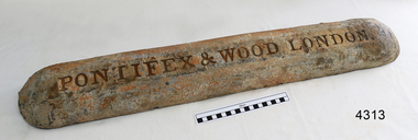
Functional object - Lead Ingot, circa 1878
This lead ingot was donated to Flagstaff Hill Maritime Village in January 2015 by local residents who discovered the ingot in their garden after they purchased the property about 12 months ago The LOCH ARD cargo manifest lists “Pig lead 50 tons” comprising “944 pig and 37 rolls”. Subsequent classification has rendered this section of cargo as “Lead Ballast”. This could be true. The international price per ton of lead ore plunged from a high point of £17 in 1853 to a low of £8 in 1882. The cheaper price of lead at the time of the vessel’s loading in early 1878 may have meant it was considered as an alternative to other ballast material (traditionally stone) for the journey to Melbourne. Loch Line ships generally returned to Britain laden with Australian wool. Even though wool bales were “screwed in” to the hold to less than half their “pressed weight”, they still made an awkwardly light cargo for the passage around the Horn. The concentrated weight of lead pigs along the keel line would help steady and centre the ship, and perhaps the artefacts in this case were to be retained for this purpose, rather than being sold on to the ready colonial market. However this is conjecture. Demand for building materials in the gold and wool rich Colony of Victoria was high in the 1870s, and much of the LOCH ARD cargo was intended for the Melbourne International Exhibition in 1880, which was another example of buoyant economic conditions. In the nineteenth century lead was valued for its density (high ratio of weight to volume), flexibility (relative softness for working into shape), and durability (corrosion resistant and waterproofing properties). It was used for pipes and water tanks, roof flashing and guttering, window sealing and internal plumbing. Many large private residences and new public buildings were at planning or construction stage in the colony during this period. The LOCH ARD lead ingots could equally have been destined for this ready market. HISTORY OF THE LOCH ARD The LOCH ARD belonged to the famous Loch Line which sailed many ships from England to Australia. Built in Glasgow by Barclay, Curdle and Co. in 1873, the LOCH ARD was a three-masted square rigged iron sailing ship. The ship measured 262ft 7" (79.87m) in length, 38ft (11.58m) in width, 23ft (7m) in depth and had a gross tonnage of 1693 tons. The LOCH ARD's main mast measured a massive 150ft (45.7m) in height. LOCH ARD made three trips to Australia and one trip to Calcutta before its final voyage. LOCH ARD left England on March 2, 1878, under the command of Captain Gibbs, a newly married, 29 year old. She was bound for Melbourne with a crew of 37, plus 17 passengers and a load of cargo. The general cargo reflected the affluence of Melbourne at the time. On board were straw hats, umbrella, perfumes, clay pipes, pianos, clocks, confectionary, linen and candles, as well as a heavier load of railway irons, cement, lead and copper. There were items included that intended for display in the Melbourne International Exhibition in 1880. The voyage to Port Phillip was long but uneventful. At 3am on June 1, 1878, Captain Gibbs was expecting to see land and the passengers were becoming excited as they prepared to view their new homeland in the early morning. But LOCH ARD was running into a fog which greatly reduced visibility. Captain Gibbs was becoming anxious as there was no sign of land or the Cape Otway lighthouse. At 4am the fog lifted. A man aloft announced that he could see breakers. The sheer cliffs of Victoria's west coast came into view, and Captain Gibbs realised that the ship was much closer to them than expected. He ordered as much sail to be set as time would permit and then attempted to steer the vessel out to sea. On coming head on into the wind, the ship lost momentum, the sails fell limp and LOCH ARD's bow swung back. Gibbs then ordered the anchors to be released in an attempt to hold its position. The anchors sank some 50 fathoms - but did not hold. By this time LOCH ARD was among the breakers and the tall cliffs of Mutton Bird Island rose behind the ship. Just half a mile from the coast, the ship's bow was suddenly pulled around by the anchor. The captain tried to tack out to sea, but the ship struck a reef at the base of Mutton Bird Island, near Port Campbell. Waves broke over the ship and the top deck was loosened from the hull. The masts and rigging came crashing down knocking passengers and crew overboard. When a lifeboat was finally launched, it crashed into the side of LOCH ARD and capsized. Tom Pearce, who had launched the boat, managed to cling to its overturned hull and shelter beneath it. He drifted out to sea and then on the flood tide came into what is now known as LOCH ARD Gorge. He swam to shore, bruised and dazed, and found a cave in which to shelter. Some of the crew stayed below deck to shelter from the falling rigging but drowned when the ship slipped off the reef into deeper water. Eva Carmichael had raced onto deck to find out what was happening only to be confronted by towering cliffs looming above the stricken ship. In all the chaos, Captain Gibbs grabbed Eva and said, "If you are saved Eva, let my dear wife know that I died like a sailor". That was the last Eva Carmichael saw of the captain. She was swept off the ship by a huge wave. Eva saw Tom Pearce on a small rocky beach and yelled to attract his attention. He dived in and swam to the exhausted woman and dragged her to shore. He took her to the cave and broke open case of brandy which had washed up on the beach. He opened a bottle to revive the unconscious woman. A few hours later Tom scaled a cliff in search of help. He followed hoof prints and came by chance upon two men from nearby Glenample Station three and a half miles away. In a state of exhaustion, he told the men of the tragedy. Tom returned to the gorge while the two men rode back to the station to get help. By the time they reached LOCH ARD Gorge, it was cold and dark. The two shipwreck survivors were taken to Glenample Station to recover. Eva stayed at the station for six weeks before returning to Ireland, this time by steamship. In Melbourne, Tom Pearce received a hero's welcome. He was presented with the first gold medal of the Royal Humane Society of Victoria and a £1000 cheque from the Victorian Government. Concerts were performed to honour the young man's bravery and to raise money for those who lost family in the LOCH ARD disaster. Of the 54 crew members and passengers on board, only two survived: the apprentice, Tom Pearce and the young woman passenger, Eva Carmichael, who lost all of her family in the tragedy. Ten days after the LOCH ARD tragedy, salvage rights to the wreck were sold at auction for £2,120. Cargo valued at £3,000 was salvaged and placed on the beach, but most washed back into the sea when another storm developed. The wreck of LOCH ARD still lies at the base of Mutton Bird Island. Much of the cargo has now been salvaged and some was washed up into what is now known as LOCH ARD Gorge. Cargo and artefacts have also been illegally salvaged over many years before protective legislation was introduced. One of the most unlikely pieces of cargo to have survived the shipwreck was a Minton porcelain peacock - one of only nine in the world. The peacock was destined for the Melbourne International Exhibition in 1880. It had been well packed, which gave it adequate protection during the violent storm. Today, the Minton peacock can be seen at the Flagstaff Hill Maritime Museum in Warrnambool. From Australia's most dramatic shipwreck it has now become Australia's most valuable shipwreck artefact and is one of very few 'objects' on the Victorian State Heritage Register. The shipwreck of the LOCH ARD is of State significance ― Victorian Heritage Register S417 Flagstaff Hill’s collection of artefacts from LOCH ARD is significant for being one of the largest collections of artefacts from this shipwreck in Victoria. It is significant for its association with the shipwreck, which is on the Victorian Heritage Register (VHR S417). The collection is significant because of the relationship between the objects, as together they have a high potential to interpret the story of the LOCH ARD. The LOCH ARD collection is archaeologically significant as the remains of a large international passenger and cargo ship. The LOCH ARD collection is historically significant for representing aspects of Victoria’s shipping history and its potential to interpret sub-theme 1.5 of Victoria’s Framework of Historical Themes (living with natural processes). The collection is also historically significant for its association with the LOCH ARD, which was one of the worst and best known shipwrecks in Victoria’s history. Lead ingots (sometimes referred to as ‘lead ballast’ or ‘lead pigs), salvaged from the wreck of the LOCH ARD. Grey metal bars with flat base, rising in a curved moulded shape to form a smooth rounded upper face. The imprint of the maker runs along the upper surface in clearly legible capital lettering (height 3cm). Durable and heavy, with some marine staining, but in good condition. Stamped along curved surface, within oval border, "PONTIFEX & WOOD LONDON."flagstaff hill, warrnambool, shipwrecked coast, flagstaff hill maritime museum, maritime museum, shipwreck coast, flagstaff hill maritime village, great ocean road, loch line, loch ard, captain gibbs, eva carmichael, tom pearce, glenample station, mutton bird island, loch ard gorge, lead pigs, lead ingots, lead ballast, pontifex and wood, london, lead smelters -
 Ringwood and District Historical Society
Membership Certificate, Independent Order of Oddfellows, Independent Order of Oddfellows Membership Certificate belonging to R.S.Sharp 1949, 14-Mar-49
Certificate belonging to R.S. Sharp as a loyal member of the Ringwood Lodge no. 6724 of the Independent Order of Oddfellows in Victoria the Manchester Unity Friendly Society.Membership Certificate belonging to R.S.Sharp of the Independent Order of Oddfellows. Water marked exterior cover, blue with picture on inner side and printing opposite with names inserted. +Additional Keywords: Sharp, R -
 Ringwood and District Historical Society
Book, Diane Baird, Digging Into History - Goldmining in Warrandyte, 2007
Information about early mining in Victoria's first gold field. Cover photographs: Front cover - Fossickers working below the water-wheen driven stamper battery located on the south side of the Yarra River upstream of the Warrandyte Bridge. Back cover - The Old Post Office, Warrandyte, in 1906, now the premises of the Warrandyte Historical Society Museum and Archive, 111 Yarra Street.Acknowledgements: Several members of the Warrandyte Historical Society were involved in the development of this publication. It was developed and written by Diane Baird; Murray Houghton and Ted Rotherham provided specialist historical details and further references; Jo Laurence and Shirley Rotherham collected and identified photographs; Brian Laurence prepared images for electronic format; and Richard Morton edited and formatted the text. The Society gratefully acknowledges the dedicated work of all its members who collect, preserve and share Warrandyte's history. In particular, the research by the late Bruce Bence and the dedicated work of the late Jo Laurence have been an invaluable contribution to the history of Warrandyte. -
 Flagstaff Hill Maritime Museum and Village
Cap Liner
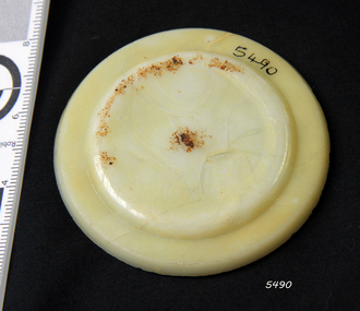
The iron-hulled, four-masted barque, the Falls of Halladale, was a bulk carrier of general cargo. She left New York in August 1908 on her way to Melbourne and Sydney. In her hold, along with 56,763 tiles of unusual beautiful green American slates (roofing tiles), 5,673 coils of barbed wire, 600 stoves, 500 sewing machines, 6500 gallons of oil, 14400 gallons of benzene, and many other manufactured items, were 117 cases of crockery and glassware. Three months later and close to her destination, a navigational error caused the Falls of Halladale to be wrecked on a reef off the Peterborough headland at 3 am on the morning of the 15th of November, 1908. The captain and 29 crew members all survived, but her valuable cargo was largely lost, despite two salvage attempts in 1908-09 and 1910. ABOUT THE ‘FALLS OF HALLADALE’ (1886 - 1908) Built: in1886 by Russell & Co., Greenock shipyards, River Clyde, Scotland, UK. The company was founded in 1870 (or 1873) as a partnership between Joseph Russell (1834-1917), Anderson Rodger and William Todd Lithgow. During the period 1882-92 Russell & Co., standardised designs, which sped up their building process so much that they were able to build 271 ships over that time. In 1886 they introduced a 3000 ton class of sailing vessel with auxiliary engines and brace halyard winches. In 1890 they broke the world output record. Owner: Falls Line, Wright, Breakenridge & Co, 111 Union Street, Glasgow, Scotland. Configuration: Four masted sailing ship; iron-hulled barque; iron masts, wire rigging, fore & aft lifting bridges. Size: Length 83.87m x Breadth 12.6m x Depth 7.23m, Gross tonnage 2085 ton Wrecked: the night of 14th November 1908, Curdies Inlet, Peterborough south west Victoria Crew: 29 The Falls of Halladale was a four-masted sailing ship built-in 1886 in Glasgow, Scotland, for the long-distance cargo trade and was mostly used for Pacific grain trade. She was owned by Wright, Breakenridge & Co of Glasgow and was one of several Falls Line ships, all of which were named after waterfalls in Scotland. The lines flag was of red, blue and white vertical stripes. The Falls of Halladale had a sturdy construction built to carry maximum cargo and able to maintain full sail in heavy gales, one of the last of the ‘windjammers’ that sailed the Trade Route. She and her sister ship, the Falls of Garry, were the first ships in the world to include fore and aft lifting bridges. Previous to this, heavily loaded vessels could have heavy seas break along the full length of the deck, causing serious injury or even death to those on deck. The new, raised catwalk-type decking allowed the crew to move above the deck stormy conditions. This idea is still used today on the most modern tankers and cargo vessels and has proved to be an important step forward in the safety of men at sea. On 4th August 1908, with new sails, 29 crew, and 2800 tons of cargo, the Falls of Halladale left New York, bound for Melbourne and Sydney via the Cape of Good Hope. The cargo on board was valued at £35,000 and included 56,763 tiles of American slate roofing tiles (roof slates), 5,673 coils of barbed wire, 600 stoves, 500 sewing machines, 6,500 gallons of oil, 14,400 gallons of benzene, plumbing iron, 117 cases of crockery and glassware and many other manufactured items. The Falls of Halladale had been at sail for 102 days when, at 3 am on the night of 14th November 1908, under full sail in calm seas with a six knots breeze behind and misleading fog along the coast, the great vessel rose upon an ocean swell and settled on top of a submerged reef near Peterborough on the south-west Victoria’s coast. The ship was jammed on the rocks and began filling with water. The crew launched the two lifeboats and all 29 crew landed safely on the beach over 4 miles away at the Bay of Islands. The postmistress at Peterborough, who kept a watch for vessels in distress, saw the stranding and sent out an alert to the local people. A rescue party went to the aid of the sailors and the Port Campbell rocket crew was dispatched, but the crew had all managed to reach shore safely by the time help arrived. The ship stayed in full sail on the rocky shelf for nearly two months, attracting hundreds of sightseers who watched her slowly disintegrate until the pounding seas and dynamiting by salvagers finally broke her back, and her remains disappeared back into deeper water. The valuable cargo was largely lost, despite two salvage attempts in 1908-09 and 1910. Further salvage operations were made from 1974-1986, during which time 22,000 slate tiles were recovered with the help of 14 oil drums to float them, plus personal artefacts, ship fittings, reams of paper and other items. The Court of Marine Inquiry in Melbourne ruled that the foundering of the ship was entirely due to Captain David Wood Thomson’s navigational error, not too technical failure of the Clyde-built ship. The shipwreck is a popular site for divers, about 300m offshore and in 3 – 15m of water. Some of the original cargo can be seen at the site, including pieces of roof slate and coils of barbed wire. The Falls of Halladale shipwreck is listed on the Victorian Heritage Register (No. S255). She was one of the last ships to sail the Trade Routes. She is one of the first vessels to have fore and aft lifting bridges. She is an example of the remains of an International Cargo Ship and also represents aspects of Victoria’s shipping industry. The wreck is protected as a Historic Shipwreck under the Commonwealth Historic Shipwrecks Act (1976).Alabaster milk jar lid insert. Has a chip on the side. Recovered from the Falls of Halladale.flagstaff hill, warrnambool, shipwrecked coast, flagstaff hill maritime museum, maritime museum, shipwreck coast, flagstaff hill maritime village, great ocean road, falls of halladale, shipwreck peterborough, 1908 shipwreck, great clipper ships, russell & co., cap liner -
 Flagstaff Hill Maritime Museum and Village
Cap Liner
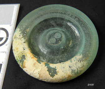
The iron-hulled, four-masted barque, the Falls of Halladale, was a bulk carrier of general cargo. She left New York in August 1908 on her way to Melbourne and Sydney. In her hold, along with 56,763 tiles of unusual beautiful green American slates (roofing tiles), 5,673 coils of barbed wire, 600 stoves, 500 sewing machines, 6500 gallons of oil, 14400 gallons of benzene, and many other manufactured items, were 117 cases of crockery and glassware. Three months later and close to her destination, a navigational error caused the Falls of Halladale to be wrecked on a reef off the Peterborough headland at 3 am on the morning of the 15th of November, 1908. The captain and 29 crew members all survived, but her valuable cargo was largely lost, despite two salvage attempts in 1908-09 and 1910. ABOUT THE ‘FALLS OF HALLADALE’ (1886 - 1908) Built: in1886 by Russell & Co., Greenock shipyards, River Clyde, Scotland, UK. The company was founded in 1870 (or 1873) as a partnership between Joseph Russell (1834-1917), Anderson Rodger and William Todd Lithgow. During the period 1882-92 Russell & Co., standardised designs, which sped up their building process so much that they were able to build 271 ships over that time. In 1886 they introduced a 3000 ton class of sailing vessel with auxiliary engines and brace halyard winches. In 1890 they broke the world output record. Owner: Falls Line, Wright, Breakenridge & Co, 111 Union Street, Glasgow, Scotland. Configuration: Four masted sailing ship; iron-hulled barque; iron masts, wire rigging, fore & aft lifting bridges. Size: Length 83.87m x Breadth 12.6m x Depth 7.23m, Gross tonnage 2085 ton Wrecked: the night of 14th November 1908, Curdies Inlet, Peterborough south west Victoria Crew: 29 The Falls of Halladale was a four-masted sailing ship built-in 1886 in Glasgow, Scotland, for the long-distance cargo trade and was mostly used for Pacific grain trade. She was owned by Wright, Breakenridge & Co of Glasgow and was one of several Falls Line ships, all of which were named after waterfalls in Scotland. The lines flag was of red, blue and white vertical stripes. The Falls of Halladale had a sturdy construction built to carry maximum cargo and able to maintain full sail in heavy gales, one of the last of the ‘windjammers’ that sailed the Trade Route. She and her sister ship, the Falls of Garry, were the first ships in the world to include fore and aft lifting bridges. Previous to this, heavily loaded vessels could have heavy seas break along the full length of the deck, causing serious injury or even death to those on deck. The new, raised catwalk-type decking allowed the crew to move above the deck stormy conditions. This idea is still used today on the most modern tankers and cargo vessels and has proved to be an important step forward in the safety of men at sea. On 4th August 1908, with new sails, 29 crew, and 2800 tons of cargo, the Falls of Halladale left New York, bound for Melbourne and Sydney via the Cape of Good Hope. The cargo on board was valued at £35,000 and included 56,763 tiles of American slate roofing tiles (roof slates), 5,673 coils of barbed wire, 600 stoves, 500 sewing machines, 6,500 gallons of oil, 14,400 gallons of benzene, plumbing iron, 117 cases of crockery and glassware and many other manufactured items. The Falls of Halladale had been at sail for 102 days when, at 3 am on the night of 14th November 1908, under full sail in calm seas with a six knots breeze behind and misleading fog along the coast, the great vessel rose upon an ocean swell and settled on top of a submerged reef near Peterborough on the south-west Victoria’s coast. The ship was jammed on the rocks and began filling with water. The crew launched the two lifeboats and all 29 crew landed safely on the beach over 4 miles away at the Bay of Islands. The postmistress at Peterborough, who kept a watch for vessels in distress, saw the stranding and sent out an alert to the local people. A rescue party went to the aid of the sailors and the Port Campbell rocket crew was dispatched, but the crew had all managed to reach shore safely by the time help arrived. The ship stayed in full sail on the rocky shelf for nearly two months, attracting hundreds of sightseers who watched her slowly disintegrate until the pounding seas and dynamiting by salvagers finally broke her back, and her remains disappeared back into deeper water. The valuable cargo was largely lost, despite two salvage attempts in 1908-09 and 1910. Further salvage operations were made from 1974-1986, during which time 22,000 slate tiles were recovered with the help of 14 oil drums to float them, plus personal artefacts, ship fittings, reams of paper and other items. The Court of Marine Inquiry in Melbourne ruled that the foundering of the ship was entirely due to Captain David Wood Thomson’s navigational error, not too technical failure of the Clyde-built ship. The shipwreck is a popular site for divers, about 300m offshore and in 3 – 15m of water. Some of the original cargo can be seen at the site, including pieces of roof slate and coils of barbed wire. The Falls of Halladale shipwreck is listed on the Victorian Heritage Register (No. S255). She was one of the last ships to sail the Trade Routes. She is one of the first vessels to have fore and aft lifting bridges. She is an example of the remains of an International Cargo Ship and also represents aspects of Victoria’s shipping industry. The wreck is protected as a Historic Shipwreck under the Commonwealth Historic Shipwrecks Act (1976).Semi-opaque glass fruit jar lid with Patd.APR 25.82 Has piece missing from the side and a light encrustation. Recovered from the Falls of Halladale.flagstaff hill, warrnambool, shipwrecked coast, flagstaff hill maritime museum, maritime museum, shipwreck coast, flagstaff hill maritime village, great ocean road, falls of halladale, shipwreck peterborough, 1908 shipwreck, great clipper ships, russell & co., cap liner -
 Flagstaff Hill Maritime Museum and Village
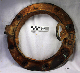
Functional object - Porthole Frame, ca. 1908
The iron-hulled, four-masted barque, the Falls of Halladale, was a bulk carrier of general cargo. She left New York in August 1908 on her way to Melbourne and Sydney. In her hold, along with 56,763 tiles of unusual beautiful green American slates (roofing tiles), 5,673 coils of barbed wire, 600 stoves, 500 sewing machines, 6500 gallons of oil, 14400 gallons of benzene, and many other manufactured items, were 117 cases of crockery and glassware. Three months later and close to her destination, a navigational error caused the Falls of Halladale to be wrecked on a reef off the Peterborough headland at 3 am on the morning of the 15th of November, 1908. The captain and 29 crew members all survived, but her valuable cargo was largely lost, despite two salvage attempts in 1908-09 and 1910. ABOUT THE ‘FALLS OF HALLADALE’ (1886 - 1908) Built: in1886 by Russell & Co., Greenock shipyards, River Clyde, Scotland, UK. The company was founded in 1870 (or 1873) as a partnership between Joseph Russell (1834-1917), Anderson Rodger and William Todd Lithgow. During the period 1882-92 Russell & Co., standardised designs, which sped up their building process so much that they were able to build 271 ships over that time. In 1886 they introduced a 3000 ton class of sailing vessel with auxiliary engines and brace halyard winches. In 1890 they broke the world output record. Owner: Falls Line, Wright, Breakenridge & Co, 111 Union Street, Glasgow, Scotland. Configuration: Four masted sailing ship; iron-hulled barque; iron masts, wire rigging, fore & aft lifting bridges. Size: Length 83.87m x Breadth 12.6m x Depth 7.23m, Gross tonnage 2085 ton Wrecked: the night of 14th November 1908, Curdies Inlet, Peterborough south west Victoria Crew: 29 The Falls of Halladale was a four-masted sailing ship built-in 1886 in Glasgow, Scotland, for the long-distance cargo trade and was mostly used for Pacific grain trade. She was owned by Wright, Breakenridge & Co of Glasgow and was one of several Falls Line ships, all of which were named after waterfalls in Scotland. The lines flag was of red, blue and white vertical stripes. The Falls of Halladale had a sturdy construction built to carry maximum cargo and able to maintain full sail in heavy gales, one of the last of the ‘windjammers’ that sailed the Trade Route. She and her sister ship, the Falls of Garry, were the first ships in the world to include fore and aft lifting bridges. Previous to this, heavily loaded vessels could have heavy seas break along the full length of the deck, causing serious injury or even death to those on deck. The new, raised catwalk-type decking allowed the crew to move above the deck stormy conditions. This idea is still used today on the most modern tankers and cargo vessels and has proved to be an important step forward in the safety of men at sea. On 4th August 1908, with new sails, 29 crew, and 2800 tons of cargo, the Falls of Halladale left New York, bound for Melbourne and Sydney via the Cape of Good Hope. The cargo on board was valued at £35,000 and included 56,763 tiles of American slate roofing tiles (roof slates), 5,673 coils of barbed wire, 600 stoves, 500 sewing machines, 6,500 gallons of oil, 14,400 gallons of benzene, plumbing iron, 117 cases of crockery and glassware and many other manufactured items. The Falls of Halladale had been at sail for 102 days when, at 3 am on the night of 14th November 1908, under full sail in calm seas with a six knots breeze behind and misleading fog along the coast, the great vessel rose upon an ocean swell and settled on top of a submerged reef near Peterborough on the south-west Victoria’s coast. The ship was jammed on the rocks and began filling with water. The crew launched the two lifeboats and all 29 crew landed safely on the beach over 4 miles away at the Bay of Islands. The postmistress at Peterborough, who kept a watch for vessels in distress, saw the stranding and sent out an alert to the local people. A rescue party went to the aid of the sailors and the Port Campbell rocket crew was dispatched, but the crew had all managed to reach shore safely by the time help arrived. The ship stayed in full sail on the rocky shelf for nearly two months, attracting hundreds of sightseers who watched her slowly disintegrate until the pounding seas and dynamiting by salvagers finally broke her back, and her remains disappeared back into deeper water. The valuable cargo was largely lost, despite two salvage attempts in 1908-09 and 1910. Further salvage operations were made from 1974-1986, during which time 22,000 slate tiles were recovered with the help of 14 oil drums to float them, plus personal artefacts, ship fittings, reams of paper and other items. The Court of Marine Inquiry in Melbourne ruled that the foundering of the ship was entirely due to Captain David Wood Thomson’s navigational error, not too technical failure of the Clyde-built ship. The shipwreck is a popular site for divers, about 300m offshore and in 3 – 15m of water. Some of the original cargo can be seen at the site, including pieces of roof slate and coils of barbed wire. The Falls of Halladale shipwreck is listed on the Victorian Heritage Register (No. S255). She was one of the last ships to sail the Trade Routes. She is one of the first vessels to have fore and aft lifting bridges. She is an example of the remains of an International Cargo Ship and also represents aspects of Victoria’s shipping industry. The wreck is protected as a Historic Shipwreck under the Commonwealth Historic Shipwrecks Act (1976).Porthole frame from the wreck of the Falls of Halladale. The encrusted frame has provision for eight bolts to hold it in place.flagstaff hill, warrnambool, shipwrecked coast, flagstaff hill maritime museum, maritime museum, shipwreck coast, flagstaff hill maritime village, great ocean road, falls of halladale, shipwreck peterborough, 1908 shipwreck, great clipper ships, russell & co., porthole frame -
 Flagstaff Hill Maritime Museum and Village
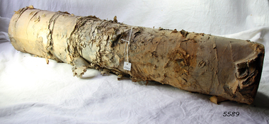
Functional object - Paper, circa 1908
This roll or reel of paper was part of a consignment carried as cargo of the Falls of Halladale. The iron-hulled, four-masted barque, the Falls of Halladale, was a bulk carrier of general cargo. She left New York in August 1908 on her way to Melbourne and Sydney. In her hold, along with 56,763 tiles of unusual beautiful green American slates (roofing tiles), 5,673 coils of barbed wire, 600 stoves, 500 sewing machines, 6500 gallons of oil, 14400 gallons of benzene, and many other manufactured items, were 117 cases of crockery and glassware. Three months later and close to her destination, a navigational error caused the Falls of Halladale to be wrecked on a reef off the Peterborough headland at 3 am on the morning of the 15th of November, 1908. The captain and 29 crew members all survived, but her valuable cargo was largely lost, despite two salvage attempts in 1908-09 and 1910. ABOUT THE ‘FALLS OF HALLADALE’ (1886 - 1908) Built: in1886 by Russell & Co., Greenock shipyards, River Clyde, Scotland, UK. The company was founded in 1870 (or 1873) as a partnership between Joseph Russell (1834-1917), Anderson Rodger and William Todd Lithgow. During the period 1882-92 Russell & Co., standardised designs, which sped up their building process so much that they were able to build 271 ships over that time. In 1886 they introduced a 3000 ton class of sailing vessel with auxiliary engines and brace halyard winches. In 1890 they broke the world output record. Owner: Falls Line, Wright, Breakenridge & Co, 111 Union Street, Glasgow, Scotland. Configuration: Four masted sailing ship; iron-hulled barque; iron masts, wire rigging, fore & aft lifting bridges. Size: Length 83.87m x Breadth 12.6m x Depth 7.23m, Gross tonnage 2085 ton Wrecked: the night of 14th November 1908, Curdies Inlet, Peterborough south west Victoria Crew: 29 The Falls of Halladale was a four-masted sailing ship built-in 1886 in Glasgow, Scotland, for the long-distance cargo trade and was mostly used for Pacific grain trade. She was owned by Wright, Breakenridge & Co of Glasgow and was one of several Falls Line ships, all of which were named after waterfalls in Scotland. The lines flag was of red, blue and white vertical stripes. The Falls of Halladale had a sturdy construction built to carry maximum cargo and able to maintain full sail in heavy gales, one of the last of the ‘windjammers’ that sailed the Trade Route. She and her sister ship, the Falls of Garry, were the first ships in the world to include fore and aft lifting bridges. Previous to this, heavily loaded vessels could have heavy seas break along the full length of the deck, causing serious injury or even death to those on deck. The new, raised catwalk-type decking allowed the crew to move above the deck stormy conditions. This idea is still used today on the most modern tankers and cargo vessels and has proved to be an important step forward in the safety of men at sea. On 4th August 1908, with new sails, 29 crew, and 2800 tons of cargo, the Falls of Halladale left New York, bound for Melbourne and Sydney via the Cape of Good Hope. The cargo on board was valued at £35,000 and included 56,763 tiles of American slate roofing tiles (roof slates), 5,673 coils of barbed wire, 600 stoves, 500 sewing machines, 6,500 gallons of oil, 14,400 gallons of benzene, plumbing iron, 117 cases of crockery and glassware and many other manufactured items. The Falls of Halladale had been at sail for 102 days when, at 3 am on the night of 14th November 1908, under full sail in calm seas with a six knots breeze behind and misleading fog along the coast, the great vessel rose upon an ocean swell and settled on top of a submerged reef near Peterborough on the south-west Victoria’s coast. The ship was jammed on the rocks and began filling with water. The crew launched the two lifeboats and all 29 crew landed safely on the beach over 4 miles away at the Bay of Islands. The postmistress at Peterborough, who kept a watch for vessels in distress, saw the stranding and sent out an alert to the local people. A rescue party went to the aid of the sailors and the Port Campbell rocket crew was dispatched, but the crew had all managed to reach shore safely by the time help arrived. The ship stayed in full sail on the rocky shelf for nearly two months, attracting hundreds of sightseers who watched her slowly disintegrate until the pounding seas and dynamiting by salvagers finally broke her back, and her remains disappeared back into deeper water. The valuable cargo was largely lost, despite two salvage attempts in 1908-09 and 1910. Further salvage operations were made from 1974-1986, during which time 22,000 slate tiles were recovered with the help of 14 oil drums to float them, plus personal artefacts, ship fittings, reams of paper and other items. The Court of Marine Inquiry in Melbourne ruled that the foundering of the ship was entirely due to Captain David Wood Thomson’s navigational error, not too technical failure of the Clyde-built ship. The shipwreck is a popular site for divers, about 300m offshore and in 3 – 15m of water. Some of the original cargo can be seen at the site, including pieces of roof slate and coils of barbed wire. The roll of paper is an example of cargo brought to Australia in the early 20th century. It is also significant for its association with the Falls of Halladale shipwreck, which is listed on the Victorian Heritage Register (No. S255). She was one of the last ships to sail the Trade Routes. She is one of the first vessels to have fore and aft lifting bridges. She is an example of the remains of an International Cargo Ship and also represents aspects of Victoria’s shipping industry. The wreck is protected as a Historic Shipwreck under the Commonwealth Historic Shipwrecks Act (1976).Roll of paper. Paper has remains of a wooden peg up through the centre and a lot of sedimentation. This roll was recovered from the wreck of the Falls of Halladale. It was part of a large consignment of paper listed as part of the cargo manifesto.flagstaff hill, warrnambool, shipwrecked coast, flagstaff hill maritime museum, maritime museum, shipwreck coast, flagstaff hill maritime village, great ocean road, falls of halladale, shipwreck peterborough, 1908 shipwreck, great clipper ships, russell & co., paper, reel, roll, paper reel, paper roll, cargo, consignment -
 Warrnambool and District Historical Society Inc.
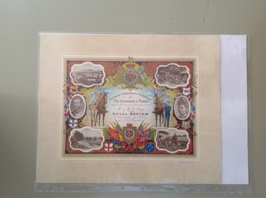
Certificate - Royal Review 1901 G Rolfe, 1901
This certificate was sent to those who had been present at one of the celebrations in connection with the Federation of the six States of Australia in 1901 – The Royal Review at Flemington Racecourse on 10th May 1901. The invitation to attend the event was issued by the Government of Victoria. The certificate was intended to be kept as a souvenir of the event and framed. This particular certificate was issued to George Rolfe and his wife of Warrnambool. George Rolfe (1836-1919), a tea merchant from Melbourne, began buying blocks of land near the mouth of the Hopkins River in Warrnambool in the 1870s. By the early 1880s he had acquired 50 acres of land in the town and several farming properties. He used the buildings on the land near the mouth of the Hopkins River as holiday accommodation and called the property, Lyndoch. He improved the property by adding stables, chaff and bone sheds, jetty, boathouse, reservoir, water well and windmill and extensive gardens and he spent most of his later life in the Warrnambool area. Lyndoch today is the site of an aged care facility. This certificate is of considerable importance for two reasons: 1. It is an important memento of a signal event on Australia’s history – the Federation of the six States in 1901 and the subsequent celebrations. 2. The certificate was issued to a prominent Warrnambool person, George Rolfe and his wife.This is multi-coloured sheet of paper mounted on card. There are four black and white photographs of the Royal Review at Flemington and photographs of the Duke and Duchess of Cornwall and York. The images include the Royal Crest, the shields of the six Australian States, a shield of Victoria with a background of flags, cannon and ammunition, two mounted soldiers with a soldier and sailor standing nearby and swords and bayonets. There is also much colour decoration around the edges of the certificate. The names of Mr and Mrs Rolfe are handwritten in black ink. ‘Australian Commonwealth Celebrations’ ‘The Government of Victoria requests the honour of the presence of Mr & Mrs G. Rolfe at the Royal Review at Flemington on Friday the 10th of May 1901’ federation of australian states, george rolfe of lyndoch, history of warrnambool, george rolfe -
 Warrnambool and District Historical Society Inc.
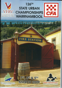
Programme - Booklet, CFA 126 Championship, 2009
The Warrnambool Fire Brigade was formed in 1863. The first fire engine house was in Liebig Street and carters were required to carry water to fire scenes. In 1889 the Council built a new Fire Station on Liebig Street and Warrnambool hosted its own Annual Demonstration in 1894. In 1891 the volunteer brigade became part of the Country Fire Brigade. The Fire Station relocated to Raglan Parade in 1915 and then to Timor Street in 1961. In 1989 the Brigade moved back to Raglan Parade. This booklet is a memento of the State Urban Championships that were held in Warrnambool in 2009 (Volunteer Fire Brigades Victoria and Country Fire Authority)This is a booklet of 96 pages containing printed material, maps, advertisements, photographs and tables. The back cover is white with a Powercor Australia symbol in red and printed material. The front cover is multi-coloured with a photograph of the Fire Station at Flagstaff Hill Maritime Village. The pages are stapled.Front Cover: VFBV, Volunteer Fire Brigades Victoria, CWA, 126th State Urban Championships, 7th, 8th and 9th March 2009, Victorian State Senior Championships, Warrnambool 2009, Warrnambool City Council logowarrnambool fire brigade, state urban championships (2009) -
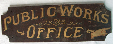 Warrnambool and District Historical Society Inc.
Sign - Public Works Office
This sign points has two different messages. The first states Public Works Office, which was operational in Victoria between 1855 and 1987 dealt with many aspects of the states infrastructure. It had many different reponsibilities and roles from building government accommodation and fit out of buildings, licences for unused roads and water ways, main roads and bridges, ports and harbour,and water supplies. Much of this work was managed through local offices such as the one at Warrnambool. The sign on the reverse which states Witnesses Waiting Room relates to the court house which is where this sign originated.The Warrnambool court house was built in 1870-71 by the Victorian Public Works department and it is possible that this sign relates to that period.It is one of a number of public buildings built in the period 1870-1890 including the Police station and stables and police quarters, the Post Office and drill Hall , all in the same vicinity. This building reflects the growth of the town and also the importance it held at the time from a state level. The building while no longer used as a court house is a building of significance to Warrnambool as well as to the state of Victoria, being one of six around the state which were built in free classical style. This sign denotes the waiting room for witnesses which was situated on the western side of the building.A tangible link which provides historical and social significance to Warrnambool.Rectangular wooden sign with rounded corners. There is text on both sides painted in gold paint with shadow in black. One side is a darker brown stain . There are screw holes in each corner.and one hole on left middle of sign. Rounded edge on one side.Side 1:Witnesses Waiting Room Side 2:Public Works Office.warrnambool, warrnambool court house, public works department warrnambool -
 Warrnambool and District Historical Society Inc.
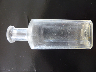
Bottle, H London Chemist & Dentist, Early 20th century
This bottle was used in the pharmacy of Harry London of Warrnambool. Born in England, Harry London arrived in Victoria in 1883 and worked as a chemist in Ballarat and Euroa. In 1891 he went back to England where he studied dentistry. In 1891 he came to Warrnambool where he bought the pharmacy business of the late William Nettleton. He occupied the Nettleton building in Liebig Street (95 Liebig Street today) until 1896 when he erected new premises at the south west corner of Liebig and Koroit Streets. At that time he was the only chemist in Warrnambool using a Pasteur filter for water to make up his medicines. In his dentistry business he used gas, chloroform and cocaine as anaesthetics. The making of dentures was his speciality. In 1904 he was the owner of the only set of Rontgen X Ray apparatus in Warrnambool. In 1905 his shop was the first in Warrnambool to have electric lighting installed. This item is a valuable one as it has local provenance. It came from the pharmacy business of Harry London, a prominent Warrnambool chemist in the late 19th and early 20th centuries. Harry London mementoes such as this are comparatively rare. This is a chemist’s glass bottle with a rectangular body, a circular neck and a rounded top. There is no stopper and the bottle is empty. The top has a small chip. The name of the chemist is embossed on the front of the bottle in an indented section of the glass. The bottle is slightly scratched and discoloured from the original contents. On front of bottle: ‘H. London Chemist & Dentist Warrnambool’ On base: ‘M’ On the body of the bottle: ‘31’ harry london, chemist, warrnambool chemists, history of warrnambool -
 Kiewa Valley Historical Society
Photograph - Kiewa River in flood at Clover Dam
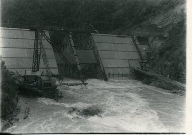
As part of the push to cut electricity costs and diversify supply, the Victorian Government (circa 1930) implemented the conversion strategy from mainly brown coal supply to hydro - electricity. The Kiewa Hydroelectric Scheme became the largest scheme of its kind in the State Of Victoria and the second largest scheme in Australia. Clover Dam and Power Station were built by the State Electricity Commission of Victoria as part of the Kiewa Hydro Electric Scheme from the late 1930's to the early 1940's. This dam was constructed to supply water to feed four turbines (62 mega watts) at the West Kiewa Power Station. This was at the forefront of sustainable "Green" energy. Costs associated with power supplies is still a major incentive of governments, however environmentally friendly alternatives such as wind and nuclear have also made inroads. The Kiewa valley and its surrounding alpine catchment were looked at(Victorian State Government), from the beginning of the twentieth century as a source of alternate power for an ever-increasing demand for electricity by growing population and heavy industrial areas within Melbourne City and State regions. Construction of dams, such as Clover Dam provided the large quantity holding areas of water required to turn the turbines at the various power stations to provide the electricity needed. The impact of these controls by moderating water run-off from the alpine regions is beneficial in reducing flooding from thawing of snow on the alps. This by-product allows agriculture and grazing to be less vulnerable to seasonal flooding thereby resulting in a more stable annual production level.Black and white photograph of Clover Dam with Kiewa River in flood. .5mm white boarder on 3 sides of photo.Handwritten on back of photograph in black pen - Kiewa in flood. Clover Dam.clover dam, secv -
 Kiewa Valley Historical Society
Photograph - Clover Dam
As part of the push to cut electricity costs and diversify supply, the Victorian Government (circa 1930) implemented the conversion strategy from mainly brown coal supply to hydro - electricity. The Kiewa Hydroelectric Scheme became the largest scheme of its kind in the State Of Victoria and the second largest scheme in Australia. Clover Dam and Power Station were built by the State Electricity Commission of Victoria as part of the Kiewa Hydro Electric Scheme from the late 1930's to the early 1940's. This dam was constructed to supply water to feed four turbines (62 mega watts) at the West Kiewa Power Station. This was at the forefront of sustainable "Green" energy. Costs associated with power supplies is still a major incentive of governments, however environmentally friendly alternatives such as wind and nuclear have also made inroads. The Kiewa valley and its surrounding alpine catchment were looked at(Victorian State Government), from the beginning of the twentieth century as a source of alternate power for an ever-increasing demand for electricity by growing population and heavy industrial areas within Melbourne City and State regions. Construction of dams, such as Clover Dam provided the large quantity holding areas of water required to turn the turbines at the various power stations to provide the electricity needed. The impact of these controls by moderating water run-off from the alpine regions is beneficial in reducing flooding from thawing of snow on the alps. This by-product allows agriculture and grazing to be less vulnerable to seasonal flooding thereby resulting in a more stable annual production level.Black and white photograph of Clover Dam buildings and Kiewa River. Has a .4cm white border around photograph Printed on bottom left corner of photograph in white - Clover Flatclover dam, secv -
 Kiewa Valley Historical Society
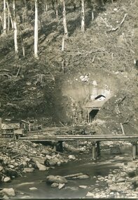
Photographs x 2 - Clover Dam, Circa 1940's
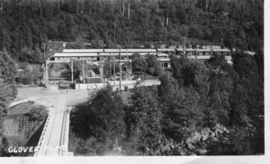
As part of the push to cut electricity costs and diversify supply, the Victorian Government (circa 1930) implemented the conversion strategy from mainly brown coal supply to hydro - electricity. The Kiewa Hydroelectric Scheme became the largest scheme of its kind in the State Of Victoria and the second largest scheme in Australia. Clover Dam and Power Station were built by the State Electricity Commission of Victoria as part of the Kiewa Hydro Electric Scheme from the late 1930's to the early 1940's. This dam was constructed to supply water to feed four turbines (62 mega watts) at the West Kiewa Power Station. This was at the forefront of sustainable "Green" energy. Costs associated with power supplies is still a major incentive of governments, however environmentally friendly alternatives such as wind and nuclear have also made inroads. The Kiewa valley and its surrounding alpine catchment were looked at(Victorian State Government), from the beginning of the twentieth century as a source of alternate power for an ever-increasing demand for electricity by growing population and heavy industrial areas within Melbourne City and State regions. Construction of dams, such as Clover Dam provided the large quantity holding areas of water required to turn the turbines at the various power stations to provide the electricity needed. The impact of these controls by moderating water run-off from the alpine regions is beneficial in reducing flooding from thawing of snow on the alps. This by-product allows agriculture and grazing to be less vulnerable to seasonal flooding thereby resulting in a more stable annual production level. Photographs also document early engineering and building techniques used in the construction of dams and power stations during the 1940’s and 1950’s. Note the lack of safety equipment and suitable work attire worn by construction workers on the sites 1. Black and white photograph of Clover Dam under construction. Has a .5cm white border around photo 2. Black and white photograph of Clover Dam under construction showing workmen at work. Has a .5cm white border around photo Written in pencil on back of both photographs - Clover Damclover dam, secv -
 Kiewa Valley Historical Society
Set of 4 photographs of SECV Clerical staff, 1940 - 1941
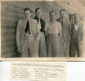
The Kiewa Hydroelectric Scheme is the largest hydro-electric scheme in Victoria and the second largest in mainland Australia after the Snowy Mountains Scheme. The scheme is situated in the Australian Alps in north-eastern Victoria about 350 km from Melbourne and is wholly owned by AGL Energy. The scheme was originally constructed between 1938 and 1961 by the State Electricity Commission of Victoria although it was privatised in the 1990s. The scheme was originally developed solely for electricity generation, unlike the Snowy Mountains Scheme, which was also intended to direct water west of the Snowy Mountains for purposes of irrigation. From 1937 to 1944 the construction of dams at Pretty Valley, Rocky Valley and the Junction Dam were undertaken requiring large numbers of planning and support staff to see the projects successfully completed. Planning and support staff were the backbone of the successful completion of the Kiewa Valley Hydro Electric Scheme and contributed significantly to the development of the Kiewa Valley area. Many descendants of the men in the photographs still living and working in the local areaSet of 4 black and white photographs of SECV clerical staff – Circa 1940/1941Typed on note glued to back of each photo, Numbers handwritten in blue ink in top left hand corner 1. DRAWING OFFICE STAFF KIEWA C. 1940-41 Bob Morgan – Construction Draftsman; Duncan Kerr – Draftsman; Rob Hollands – Survey Draftsman; Arthur Keeble – Office Engineer; Bill Godfrey – Draftsman 2. CLERICAL OFFICE STAFF KIEWA Peter Harnetty – Clerical; Bert Connors – Clerical; John Martin – Stores Clerical; Ken Calder – Head Storekeeper; Bill black – Construction Records 3. CLERICAL OFFICE STAFF KIEWA Jack Norman, Herb Kendall, Jack Bray – Stores Clerical; Ken Calder – Head Storekeeper; Jim Swain, George Milner – Stores Clerical; Jim Gleeson – Storekeeper; John Martin – Stores Clerical 4. OFFICE STAFF KIEWA C. 1940 Don Faulkner – Cadet Engineer; Tas Davies – Survey Draftsman; Bob Morgan – Construction Darftsman; R.J. Martin, Arthur Keeble – Office Engineers; Rob Hollands – Survey Draftsman; Jack Wollard – Head Surveyor; Harry Wilson – Plan Officer. Printing Plans Handwritten in red ink on back of photo 4 – Refer Rob Hollands secv clerical staff -
 Kiewa Valley Historical Society
Photograph of Ray Esdaile and unidentified man, 1950
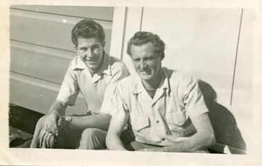
The Kiewa Hydroelectric Scheme is the largest hydro-electric scheme in Victoria and the second largest in mainland Australia after the Snowy Mountains Scheme. The scheme is situated in the Australian Alps in north-eastern Victoria about 350 km from Melbourne and is wholly owned by AGL Energy. The scheme was originally constructed between 1938 and 1961 by the State Electricity Commission of Victoria although it was privatised in the 1990s. The scheme was originally developed solely for electricity generation, unlike the Snowy Mountains Scheme, which was also intended to direct water west of the Snowy Mountains for purposes of irrigation. From 1937 to 1944 the construction of dams at Pretty Valley, Rocky Valley and the Junction Dam were undertaken requiring large numbers of planning and support staff to see the projects successfully completed. Planning and support staff were the backbone of the successful completion of the Kiewa Valley Hydro Electric Scheme and contributed significantly to the development of the Kiewa Valley area. Many descendants of the original SECV workers are still living and working in the local areaBlack and white photograph of 2 men, one identified as Ray Esdaile at Mt Beauty SEC Camp in 1950Handwritten on back of photograph in blue ink: Ray Esdaile and self (unidentified) 1950 Mt Beauty Camp SECray esdaile, secv, mt beauty -
 Kiewa Valley Historical Society
Photographs x 3- Cruise on Lake Mulwala, 25/2/1973
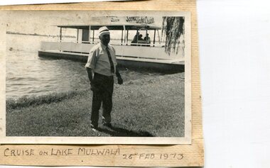
Lake Mulwala is a man–made reservoir created through the construction of the Yarrawonga Weir across the Murray River, is located between Bundalong and Yarrawonga in Hume region of Victoria and Mulwala in the Riverina region of New South Wales, in eastern Australia. The weir was constructed in 1939 to provide water for irrigation of the surrounding district. The weir also serves as a crossing of the Murray between the two towns. It is a popular tourist destination for boating, fishing and other water recreation.Photographs demonstrate local Kiewa Valley residents enjoying a visit to the picturesque area of Lake Mulwala. Also provides a pictorial history of 1973.3 black and white photographs mounted on buff card. Photographs of a cruise on Lake Mulwala 25th Feb. 1973 1. Photo of unidentified man standing on the shore of Lake Mulwala beside cruise launch. 2. Group photo of people standing by cruise boat as others disembark. Woman in centre holding handbag may be Clare Roper (unconfirmed) 3. Photo of 2 men aboard cruise launch looking out over Lake Mulwala1. Handwritten at bottom of photo in black ink. 'Cruise on Lake Mulwala. 25th Feb. 1973' 2. Painted sign above cruise launch- Scenic Lake Cruises 3. No markingsclare roper -
 Kiewa Valley Historical Society
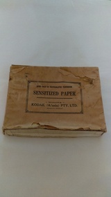
Photographs of small box originally used to contain sensitized photographic paper
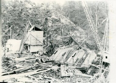
The Junction Dam and Clover Dam Power Station, stages of the Kiewa Hydro-Electric Scheme, were needed to meet the increased power demands of the wartime industry in Victoria. Clover added 26 megawatts to the grid. Junction Dam was completed and ready to hold water by September 1943, but was emptied in December 1943 and not filled again until May 1944. Construction of Clover Power Station commenced in July 1941 and both turbines were in service by May 1945.Clover Power Station and Junction Dam were part of the Kiewa Hydro Electric Scheme constructed by the State Electricity Commission of Victoria. SECV official photographers took photographs of most stages of construction of the Hydro Electric Scheme and referenced each photo with a number and dating system as an historical record and for reference for other projects. This provided a thorough history of the construction of the Hydro Electric Scheme, some of the workers involved in its construction and the infrastructure supporting its construction, such a Bogong Village.Small light brown cardboard box originally containing sensitized photographic paper, now containing a range of black and white photographs of the Kiewa Hydro Electric System taken by the official SECV photographer Box has some damage – Front panel on lid is missing. Top has a puncture in top right corner and some peeling of paper along sides and at edges. Printed on the top of the box in black ink: OPEN ONLY IN PHOTOGRAPHIC DARK ROOM SENSITIZED PAPER Manufactured by – KODAK (A/asia) PTY. LTD. Melbourne Australia Green and white sticker on right side of lid and bottom right side of box, torn at join 1. 1B1 Single Weight Soft. Available in Soft (1) Medium (2) Contrast (3) Extra Contrast (4) Single and Double Weight Stamped at bottom of sticker in grey ink G8087 CK photographic paper box; state electricity commission of victoria; official photographer; kiewa hydro electric scheme; clover power station; junction dam; bogong village -
 Kiewa Valley Historical Society
Photographs – SECV – Clover Power Station
The Junction Dam and Clover Dam Power Station, stages of the Kiewa Hydro-Electric Scheme, were needed to meet the increased power demands of the wartime industry in Victoria. Clover added 26 megawatts to the grid. Junction Dam was completed and ready to hold water by September 1943, but was emptied in December 1943 and not filled again until May 1944. Construction of Clover Power Station commenced in July 1941 and both turbines were in service by May 1945.Clover Power Station and Junction Dam were part of the Kiewa Hydro Electric Scheme constructed by the State Electricity Commission of Victoria.Set of 22 black and white photographs taken by the official SECV photographer who gave each photo a number prefixed by K (for Kiewa) K60 -no date- A bridge and entrance to tunnel K519 -no date- Welding steel lining in the tunnel K531 –no date- Construction on the Kiewa Scheme (tunnel in background K821 – no date- Bogong Village, early days K928 -15 Oct 1942- Construction Clover Power Station K947 -26 Oct 1942- Construction Clover Power Station K948 -26 Oct 1942- Construction Clover Power Station K949- 26 Oct 1942- Clover Camp in background K950 -26 Oct 1942- Construction Clover Power Station K955 -27 Oct 1942- Constructing the bridge at Clover K1102 -7 April 1943- Inlet pipe to power station K1179 –no date- Clover Power Station K1187 – no date- Clover Power Station K1189 -24 June 1943- Part of the spiral casing 1199 -7 July 1943- Clover Power Station K1201 -7 July 1943- Clover Power Station K1231 -26 July 1943- Gantry crane for Clover Power Station K1308 -6 Sept 1943- Spiral casing K1334 -6 Oct 1943- Lake Guy. Bogong Village in background K1342 -29 Oct 1943- Power station under construction K1365 -19 Nov 1943- Power station under construction K1366 -19 Nov 1943- Gantry crane for Clover Power Station On the back- each photograph has a handwritten reference number starting with K and the date stamped or written (see above)secv; kiewa hydro electric scheme; official photographer; junction dam; clover power station; bogong; -
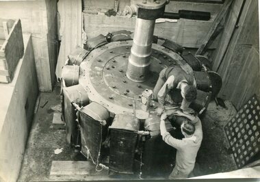 Kiewa Valley Historical Society
Photographs – SECV – Clover Power Station
The Junction Dam and Clover Dam Power Station, stages of the Kiewa Hydro-Electric Scheme, were needed to meet the increased power demands of the wartime industry in Victoria. Clover added 26 megawatts to the grid. Junction Dam was completed and ready to hold water by September 1943, but was emptied in December 1943 and not filled again until May 1944. Construction of Clover Power Station commenced in July 1941 and both turbines were in service by May 1945.Clover Power Station and Junction Dam were part of the Kiewa Hydro Electric Scheme constructed by the State Electricity Commission of Victoria.Set of 21 black and white photographs taken by the official SECV photographer who gave each photo a number prefixed by K (for Kiewa) K1367- 19 Nov 1943 The rotor for the generator K1368- 19 Nov 1943 Base of the generator K1377- 2 Dec 1943 Generator under construction K1380- 2 Dec 1943 Power Station under construction K1381- 2 Dec 1943 Generator being assembled K1386- 3 Dec 1943 Part of the generator K1389- 30 Dec 1943 Inlet pipe work K1391- 30 Dec 1943 Inside the power station K1392- 30 Dec 1943 Inlet pipe work K1396- 27 Jan 1944 Equipment in the power station K1410- 4 FGeb 1944 Unpacking equipment for the power station K1422- 16 Feb 1944 Generator being assembled K1425- 22 Feb 1944 Water way – power station K1433- no date Generator being assembled K1434- 3 Mar 1944 Constr5ucting the power station K1448- no date Generator inside the power station K1450- 17 Mar 1944 Clover Power station K1452- 17 Mar 1944 Looking down on the valve-water release from the power station K1456- 22 Mar 1944 ‘half Travel Opening- No 1 Relief Valve’ Overflow from the power station K1458- 22 Mar 1944 Outlet from the power station K1462- 22 Mar 1944 Inside the power station On the back- each photograph has a handwritten reference number starting with K and the date stamped or writtensecv; kiewa hydro electric scheme; clover power station; junction dam; bogong -
 Kiewa Valley Historical Society
Photographs – SECV – Clover Power Station
The Junction Dam and Clover Dam Power Station, stages of the Kiewa Hydro-Electric Scheme, were needed to meet the increased power demands of the wartime industry in Victoria. Clover added 26 megawatts to the grid. Junction Dam was completed and ready to hold water by September 1943, but was emptied in December 1943 and not filled again until May 1944. Construction of Clover Power Station commenced in July 1941 and both turbines were in service by May 1945Clover Power Station and Junction Dam were part of the Kiewa Hydro Electric Scheme constructed by the State Electricity Commission of VictoriaSet of 21 black and white photographs taken by the official SECV photographer who gave each photo a number prefixed by K (for Kiewa) K1463- 22 Mar 1944 Inside Clover Power Station K1464- 23 Mar 1944 Valve K1466- 23 Mar 1944 Fittings for the power station K1467- 23 Mar 1944 Valve K1472- 30 Mar 1944 Equipment being installed in Clover Power Station K1474- 31 Mar 1944 Equipment for the power station K1493- 19 April 1944 Transformer K1495- 28 April 1944 Part of the generator being installed K1514- 11 May 1944 Equipment in the power station K1563- 9 June 1944 Turbine under construction K1565- 22 June 1944 Shaft between turbine and generator K1567- 22 June 1944 Turbine in the power station K1568- 22 June 1944 Transformers K1570- 5 June 1944 Guide vane actuators K1574- 22 June 1944 Equipment in the power station K1567- 22 June 1944 Clover Power Station K1607- 14 Aug 1944 Equipment in the power station K1620- 27 Aug 1944 ‘Charles Tavare (?) Equipment in the power station K1626- 23 Aug 1944 Clover Power Station K1628- 23 Aug 1944 Clover Power Station K1629- 23 Aug 1944 Clover Power Station On the back- each photograph has a handwritten reference number starting with K and the date stamped or writtensecv; kiewa hydro electric scheme; clover power station; junction dam; bogong -
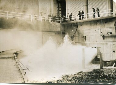 Kiewa Valley Historical Society
Photographs – SECV – Clover Power Station
The Junction Dam and Clover Dam Power Station, stages of the Kiewa Hydro-Electric Scheme, were needed to meet the increased power demands of the wartime industry in Victoria. Clover added 26 megawatts to the grid. Junction Dam was completed and ready to hold water by September 1943, but was emptied in December 1943 and not filled again until May 1944. Construction of Clover Power Station commenced in July 1941 and both turbines were in service by May 1945.Clover Power Station and Junction Dam were part of the Kiewa Hydro Electric Scheme constructed by the State Electricity Commission of VictoriaSet of black and white photographs taken by the official SECV photographer who gave each photo a number prefixed by K (for Kiewa) K1630- 23 Aug 1944 Clover Power Station K1633- no date Clover Power Station K1683- 10 Oct 1944 Weir K1700- no date Tail boy for Clover Power Station K1710- 11 Oct 1944 Part of aqueduct – Clover K1767- 6 Jan 1945 Switchboard in the power station K1769- 6 Jan 1945 Turbine and shaft K1770- 10 Jan 1945 Houses under construction at Bogong Village K1897- 22 Feb 1945 Equipment in the power station K1808- 22 Feb 1945 Equipment in the power station K1910- 31 May 1945 Top of the turbine and the shaft K1964- 16 Jul 1945 Equipment in the power station K1970- 17 Jul 1945 Bogong Village K1983- 30 Jul 1945 Turbine in power station K1984- 30 Jul 1945 Bogong Village K1989- 2 Aug 1945 Turbines in power station K1990- 2 Aug 1945 Equipment in power station K1991- 2 Aug 1945 Bogong village K2011- 28 Aug 1945 Equipment in power station K2015- 28 Aug 1945 Generators in power station K2016- 28 Aug 1945 Top of the turbine and the shaft K2018- 30 Aug 1945 Spiral casing, the turbine and the shaft On the back- each photograph has a handwritten reference number starting with K and the date stamped or writtensecv; kiewa hydro electric scheme; junction dam; clover power station; bogong -
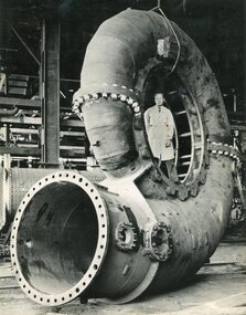 Kiewa Valley Historical Society
Photographs – SECV– Clover Power Station
The Junction Dam and Clover Dam Power Station, stages of the Kiewa Hydro-Electric Scheme, were needed to meet the increased power demands of the wartime industry in Victoria. Clover added 26 megawatts to the grid. Junction Dam was completed and ready to hold water by September 1943, but was emptied in December 1943 and not filled again until May 1944. Construction of Clover Power Station commenced in July 1941 and both turbines were in service by May 1945.Clover Power Station and Junction Dam were part of the Kiewa Hydro Electric Scheme constructed by the State Electricity Commission of Victoria.Set of 2 large black and white photographs of spiral casing for a turbine being transported to a power station on the Kiewa Scheme. Gentleman in lab coat standing inside casing in photograph 1 On the back – dark grey ink stamp “Photographed by / E.B. Studios / 309 George St., / Tel. SW 7373 Sydney” clover power station, secv -
 Kiewa Valley Historical Society
Photographs – Set of 10 black and white photographs and photocopies of original photographs documenting early residents of Bogong Village
Bogong Village, which was known as “The Junction”, is well recorded. The first tent camp was at the junction of Pretty Valley and Rocky Valley streams in the early 40’s. Further downstream were the sawmill, stables and blacksmith’s forge. Horses were the main mode of transport in the early days. The road to Bogong had reached the lookout spur just beyond Roper’s Spur track just before the 1939 fires. The early forties saw rapid growth of the village, with single and married men’s quarters, workshops, mess huts and administrative offices. The facilities necessary for communal living were quickly in place- a post office, police station, co-op store, medical centre, community hall/theatre, tennis courts and school. Much of the temporary accommodation that housed groups such as the Albion Quarrying Company were in the area now under water.This group of photographs are a pictorial record of the early history of the Kiewa Hydro Scheme, the people who worked in the background supplying administrative support and the workers and their families. It also shows a glimpse into how a large group of people from very diverse backgrounds came together to enjoy social activities and share each others companyGroup of 10 black and white photographs and photocopies of original photographs of varying sizes (some official SECV photos) Some Photos are labelled with the date and the names of SECV staff members. Depicting early life at Bogong Village 1. Group photo – Kiewa House Residents 1.8.41 (SECV official photo) 2. Female staff residents 3. Female office staff 4. Kitchen staff – Junction Mess (SECV official photo) 5. Male administration staff Bogong 6. Bogong Social Club fancy dress ball, 1940 7. Wives and children of SECV workers 8. Children in fancy dress 9. Opening of Volunteer Air Observers post 1943 10. Flag raising at opening of Volunteer Air Observers post 1. Printed under photo: STATE ELECTRICITY COMMISSION OF VICTORIA Date: 1.8.41 Time: 12.30pm No:K 435 Kiewa Hydro-Electric Works. Kiewa House Residents Back Row L to R: S.A. Salmon, W. Strachn, T.A Connors, W.J Norman, R.C Grealey, R.D Hegarty, Mrs Hegarty, W.R Morgan, S.A Clarke, P. Morgan, P.J. Harnetty, G.W Crouch. Front Row L to R: W.L Godfrey, R.S Hollands, Pte. R Charlesworth, R.L Dunn, N Caldwell, L.T Davies, I Webber, H.L Kendall, P Tiller, Ricky Hegarty, L.T Guy, M.C Cox, K.F Calder, D.S Gibson 2. Printed on bottom: Staff who lived at Kiewa House and worked in the Administration Office c 1943 Handwritten at bottom Priscilla Johnson (nee Reid) At top of page A GOOD LIFE: WOMEN’S RECOLLECTIONS OF LIFE IN THE UPPER KIEWA VALLEY 3. Printed under photo- Office Staff – Bogong 4. Printed under photo: STATE ELECTRICITY COMMISSION OF VICTORIA Date: 18.5.40 Time: 11.05am No:K 103. Kiewa Hydro-Electric Works. Kitchen Staff- Junction Mess. Opening night of the new staff mess Bogong. 5. Printed under photo -Administration staff Bogong 6. Printed under photo- The social club raised money for patriotic fund from fancy dress nights. (1st Fancy Dress Ball, Bogong 1940) 7. Printed above photo: ---- and family life begins (1942 Bogong) 8. Printed under photo: A favourite photograph 9. Printed under photo: STATE ELECTRICITY COMMISSION OF VICTORIA Date: 24.5.43 Time: 2.8pm No:K 1151 Kiewa Hydro-Electric Works. Bogong- Squadron Leader Leggett speaking at opening of Air Observer’s Post 10. Printed under photo: Raising the flag at the opening of the Volunteer Air Observer’s Post at Bogong - 1943 bogong village; kiewa hydro electric scheme; social activities; community clubs -
 Kiewa Valley Historical Society
Photographs – Set of 9 black and white photographs and photocopies of original photographs depicting the early days of Bogong Village during the 1940’s, circa 1940's
Bogong Village, which was known as “The Junction”, is well recorded. The first tent camp was at the junction of Pretty Valley and Rocky Valley streams in the early 40’s. Further downstream were the sawmill, stables and blacksmith’s forge. Horses were the main mode of transport in the early days. The road to Bogong had reached the lookout spur just beyond Roper’s Spur track just before the 1939 fires. The early forties saw rapid growth of the village, with single and married men’s quarters, workshops, mess huts and administrative offices. The facilities necessary for communal living were quickly in place- a post office, police station, co-op store, medical centre, community hall/theatre, tennis courts and school. Much of the temporary accommodation that housed groups such as the Albion Quarrying Company were in the area now under water.Pictorial history of the early years of Bogong Village including one photo taken following the devastating fires of 1939. Photos show the terrain in which Bogong Village was built, the early construction used for the temporary buildings and the housing and the amount of infrastructure required to accommodate the needs of the residents of the area including workers, their families and other support staff. Set of 9 black and white photographs and photocopies of photographs depicting early buildings at Bogong Village . Photos show very early construction buildings as well as the village in various weather conditions, including snowing and after bush fires. (some official SECV photographs) 1. Bogong Village in heavy snow 2. Bogong Township during heavy snow (SECV Official Photo) 3. VIP Lodge at Bogong in the snow 4. Bogong Village - circa 1940’s 5. Bogong Village under street lights 6. Lewis Construction Camp (SECV Official Photo) 7. Albion Quarrying Co. Camp (SECV Official Photo) 8. Tent camp and early buildings following 1939 fires 9. Typical house – Bogong Village 1. Handwritten under photo – August 1948 2. Printed under photo: STATE ELECTRICITY COMMISSION OF VICTORIA Date: 25.8.48 Time: 9am No:K 4680 Kiewa Hydro-Electric Works. Bogong Township 3. Handwritten on back of photo- V.I.P. Lodge, Bogong 4 – 5. No markings 6. Printed under photo: STATE ELECTRICITY COMMISSION OF VICTORIA Date: 28.11.40 Time: 1.40pm No:K284 Kiewa Hydro-Electric Works. Lewis Construction Camp 7. Printed under photo: STATE ELECTRICITY COMMISSION OF VICTORIA Date: 11.1.41 Time: 10.40am No:K294 Kiewa Hydro-Electric Works. Albion Quarrying Co. Camp – Bogong. Handwritten on back of photo: On the floor of the present dam 8. No markings 9. Printed under photo: STATE ELECTRICITY COMMISSION OF VICTORIA Date: 11.1.46 Time: 1.23pm No:K2181 Kiewa Hydro-Electric Works. Bogong – Typical House bogong village; 1939 fires; kiewa hydro electric scheme;