Showing 2912 items matching "australian maps"
-
 Falls Creek Historical Society
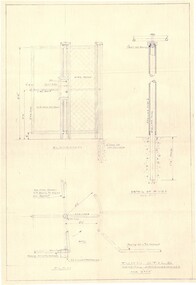
Plan - Diagram of Turnstile for New Chairlift
Bob (Herman) Hymans (a former member of the Royal Netherlands Navy was born in Bloemendaal, Holland on 30th September 1922. During World War II he fought against the Japanese in the Dutch East Indies (now Indonesia) and was imprisoned in Changi and on the Burma Railway. After gaining qualifications as a Ski Instructor, Bob arrived in Falls Creek in May 1950. Working as an Instructor and Supervisor at Bogong Lodge, Bob decided his future was in accommodation. He was successful in negotiating an indenture for land from the State Electricity Commission (SEC). It took Bob two years to build his Grande Coeur Chalet but, tragically, it was burned down in August 1961. Bob also built the first Chairlift in Australia. This was a single chairlift and the structure was built from wooden electricity poles. He was constantly full of new ideas and proposals for the village. Bob Hymans died on 7th May 2007. This Collection of documents and letters tells the story of Bob’s endeavours to develop Falls Creek into the ski village it is today. This map is significant because it documents plans made by Bob Hymans for Falls CreekThis diagram is part of Bob Hymans documents. It is a detailed plan, including elevation, detail of pivot and the general arrangement views of a turnstile. This is part of overall plans for the construction of a new chairlift at Falls Creek. At bottom of diagrams: PLAN TURNSTILE/ GENERAL ARRANGEMENT Scale 1 1/2" = 1'- 0"map of falls creek, falls creek leases, falls creek 1980s -
 Friends of Ballarat Botanical Gardens History Group
Work on paper - National Trust of Australia (Vic), Register of Significant Trees. Ballarat Botanical Gardens. c1983, Unknown
This National Trust Register of Significant Trees in the Ballarat Botanical Gardens is an important part of Ballarat's history. Unfortunately, since 1983, some of the trees listed have died or been removed.The Ballarat Botanical Gardens has a unique collection of trees which testify to the knowledge and enthusiasm of the Curators, City fathers and Gardeners in their development of the Gardens in earlier years, especially in the nineteenth century.1 sheet of paper with three lists of the trees and the number of them in the Gardens. (1 copy)Draft printed in red under main heading. In black biro, written on the first entry, "no on map". 10th entry (Sierra Redwood) number scribbled over and "outside gate" written. 14th entry (Horizontal Elm) "3 on list, 1dead". 15th entry (Horizontal Elm) "W of 17". ballarat botanical gardens, national trust of australia (vic), register of significant trees, trees, john garner collection, gardens, ballarat -
Friends of Ballarat Botanical Gardens History Group
Work on paper - Gondwana Trees in the Ballarat Botanical Gardens, Categories and Common Features, Unknown
Part of an attempt to to categorise and identify common features of the wide range of trees in the Ballarat Botanic Gardens.This material deals with the history of Gondwana trees and those represented in Australia today that relate to plants found in the Ballarat Botanical Gardens.4 pages. p.1 Map of Pangaea (Continents) left hand 2nd half of page. p2. Map, left hand top of page and 2 photographs of foliage, 2nd half of page. p 3. 5 small photographs down left hand side of page. p.4 no photographs or maps. none.john garner, doctor, ballarat botanical gardens, gondwana trees in the ballarat botanical gardens, pangaea, trees., john garner collection, gardens, ballarat -
 Friends of Ballarat Botanical Gardens History Group
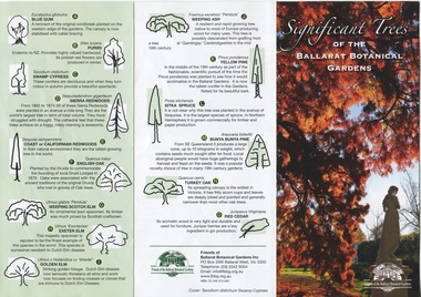
Work on paper - Significant Trees of the Ballarat Botanical Gardens, List and Map, c 2018
These trees planted in the nineteenth century are an exceptional collection of exotic conifers and deciduous trees.These trees classified by the National Trust means that the trees are an essential part of Australia's heritage and should be preserved for future generations.A coloured pamphlet divided into three parts, with trees and coloured picture on one side and a map of where the trees are situated on the other.Right hand corner of coloured picture, there is the logo of the Friends of the Ballarat Botanical Gardensjohn garner collection, dr, significant trees, ballarat botanical gardens, gardens, ballarat, map -
 Falls Creek Historical Society
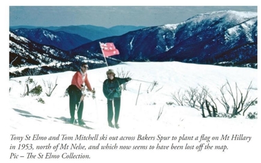
Photograph - Tom Mitchell and Toni St. Elmo plant flag at Mt. Hillary
Tom Mitchell was a strong supporter of trans-Tasman ski competitions and in the early 1950s visits between local clubs became common. In 1953 a team from New Zealand visited Falls Creek for the first time. This was only a few months after Edmund Hillary and Nepalese Sherpa Tenzig Norgay became the first climbers confirmed to have reached the summit of Mount Everest. Toni St. Elmo, supported by Tom Mitchell proposed that a peak on the Bogong High Plains northwest of Mt. Nelse should be named Mt. Hillary in honour of the New Zealander's success. He also suggested a ceremony should be held during the visit of members of the New Zealand Ski team to Australia in September 1953. This image from the St. Elimo Collection held by the Falls Creek Historical Society, represents the planting of a New Zealand flag on the mountain during the ceremony.This image is significant because it is part of the St. Elmo Collection which documents early pioneers of Falls Creek and their outstanding contribution to skiing in Australia.A coloured image of two skiers carrying a New Zealand flag across the High Plains.Beneath the image: Tony St Elmo and Tom Mitchell ski out across Bakers Spur to plant a flag on Mt Hillary in 1953, north of Mt Nelse, and which now seems to have been lost off the map. Pic - The St Elmo Collection.tom mitchell, st. elmo collection, toni st. elmo, sir edmund hillary -
Bass Coast Shire Council - Art Collection
Photograph - MAP Photos Wonthaggi, Various Photographers
Australia58 Photos -
 Bacchus Marsh & District Historical Society
Map, Lerderderg District Proposed Irrigation and Water Supply Trust (B) Plan Showing Proposed Works
The 1886 Irrigation Act in Victoria introduced the first legislation in Australia designed to enable the creation of a detailed scheme for agricultural irrigation. Part of the legislation saw the use of government funds for local irrigation projects. These local projects were managed by local irrigation trusts. The Lerderderg Irrigation and Water Supply Trust was formed in 1890. This map depicts the proposed area of the Trust and proposed works such as channels and weirs.Printed paper map of the proposed Lerderderg District Irrigation and Water Supply area showing proposed works. The map scale is 40 chains + 1 inch. The Lerderderg District lies within the Parishes of Korkuperrumul and Merrimu in the County of Bourke. At the top of the map above its title is the letter 'B; in capital lettering. A series of proposed channels are indicated on the map in red lines. A proposed weir site and alternative weir site are also indicated on the map. irrigation, water supply, lerderderg irrigation and water supply trust -
 Bacchus Marsh & District Historical Society
Map, Lerderderg District Proposed Irrigation and Water Supply Trust (C). Plan showing overlap in boundaries of the Trust District
The 1886 Irrigation Act in Victoria introduced the first legislation in Australia designed to enable the creation of a detailed scheme for agricultural irrigation. Part of the legislation saw the use of government funds for local irrigation projects. These local projects were managed by local irrigation trusts. The Lerderderg Irrigation and Water Supply Trust was formed in 1890. Printed paper map of the proposed Lerderderg District Irrigation and Water Supply. Plan showing overlap in boundaries of Trust District referred to in Mr Burke's report. The Lerderderg District lies within the Parishes of Korkuperrumul and Merrimu in the County of Bourke. At the top of the map above its title is the letter 'C; in capital lettering. A note on this map states: 'Portion of Bacchus MarshUrban District included in area of proposed Trust District shown by hatched shaded lines thus /////////////irrigation, water supply, lerderderg irrigation and water supply trust -
 Bacchus Marsh & District Historical Society
Map, Lerderderg District Proposed Irrigation and Water Supply Trust (A). Plan showing boundaries of Trust District
The 1886 Irrigation Act in Victoria introduced the first legislation in Australia designed to enable the creation of a detailed scheme for agricultural irrigation. Part of the legislation saw the use of government funds for local irrigation projects. These local projects were managed by local irrigation trusts. The Lerderderg Irrigation and Water Supply Trust] was formed in 1890. This map depicts the proposed area of the Trust.Printed paper map of the proposed Lerderderg District Irrigation and Water Supply. Plan showing boundaries of Trust District. The Lerderderg District lies within the Parishes of Korkuperrumul and Merrimu in the County of Bourke. At the top of the map above its title is the letter 'A; in capital lettering. Scale: 40 Chains = 1 inch.irrigation, water supply, lerderderg irrigation and water supply trust -
 Bacchus Marsh & District Historical Society
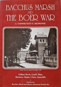
Book, Bacchus Marsh and the Boer War: A Community's Response
An account of the impact of the Boer War upon the community of Bacchus Marsh. Like many communities across Australia Bacchus Marsh saw a number of men enlist in the military forces and participate in the conflict in South Africa between Great Britain and its allies such as Australia against the Boer forces in South Africa in the early 1900s. This work documents this history from the perspective of the individual soldiers involved and the way the community responded to this conflict. Citation: Bacchus Marsh and the Boer War: A Community's Response. By Gillian Davis, Geoff Hine, Barbara Manly and Chris Stancliffe. Published by Bacchus Marsh and District Historical Society, Bacchus Marsh, Vic., 2001.A printed book published in paperback edition. 92 pages, with illustrations, portraits, and maps. BMDHS Location: AR/SU4non-fictionAn account of the impact of the Boer War upon the community of Bacchus Marsh. Like many communities across Australia Bacchus Marsh saw a number of men enlist in the military forces and participate in the conflict in South Africa between Great Britain and its allies such as Australia against the Boer forces in South Africa in the early 1900s. This work documents this history from the perspective of the individual soldiers involved and the way the community responded to this conflict. Citation: Bacchus Marsh and the Boer War: A Community's Response. By Gillian Davis, Geoff Hine, Barbara Manly and Chris Stancliffe. Published by Bacchus Marsh and District Historical Society, Bacchus Marsh, Vic., 2001.bmdhs publication, south african war 1899-1902, boer war 1899-1902, soldiers bacchus marsh vic. -
Friends of St Brigids Association
The Irish Australians : selected articles for Australian and Irish family historians, The Irish Australians : selected articles for Australian and Irish family historians / edited by Richard Reid and Keith Johnson .1984. Sydney : Society of Australian Genealogists, 1984 56 p. : ill., facsims., map, ports. ; 30 cm
-
Friends of St Brigids Association
Book - Letters from Irish Australia 1825-1929, O’Farrell, Patrick James. 1984. Letters from Irish Australia 1825-1929. Sydney : New South Wales University Press ; Belfast : Ulster Historical Foundation, 1984 244 p. : ill., maps ; 25 cm
-
Friends of St Brigids Association
Book - Croppies, Celts, and Catholics : The Irish in Australia, McConville, Chris. 1987. Croppies, Celts, and Catholics : The Irish in Australia. Caulfield East, Vic. : Edward Arnold, 1987 167 p. : ill., maps, ports. ; 25 cm
-
 The 5th/6th Battalion Royal Victoria Regiment Historical Collection
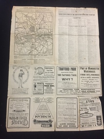
Map, Britain and Underground Railways, July 1919
Used by Australian Soldiers whilst on leave after WW1.Reversible map made of paper. One side has a map of Britain and Ireland printed in colour, the other has a map of the London underground as well as several advertisements. there are small tears along the fold lines.wark vc club, regiment property -
 The 5th/6th Battalion Royal Victoria Regiment Historical Collection
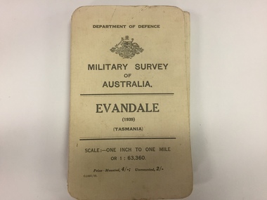
Map, Military Survey of Australia. Evandale (1939) (Tasmania), 1939
... Survey of Australia. Evandale (1939) (Tasmania) Map Map ...Fabric backed colour map, with card cover that folds into a small book. Scale one inch= one mile.military, survey, map, tasmania, ww2, wark vc club -
 The 5th/6th Battalion Royal Victoria Regiment Historical Collection
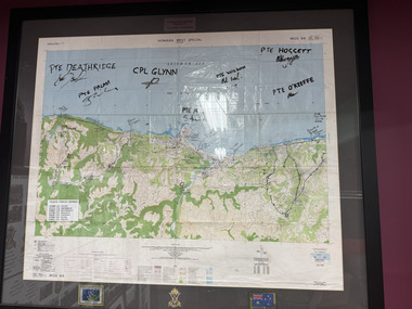
Map - Honiara Map, Honiara West Special used by members of 5/6
Honiara West Special signed by 7 members of 5/6 RVR who were deployed on Operation AnodeThe Map is framed in the glass frame withe the Operation Anode patch, Australian Flag and 5/6 unit symbol displayed below the Map. It has been signed by 7 members of 5/6, each member's PMKey is also displayed on the Map -
 Mont De Lancey
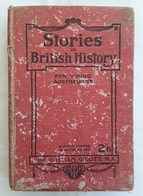
Book, William Gillies, M.A, Stories in British History for Young Australians, 1920
A simple study in British History for secondary school students with a fold out map of the British Empire at the time - published in 1920. There is a list of the dynasties and kings and queens and a table of Periods in British History which can be referred to.A badly damaged red cloth covered hardcover book with the title: Stories in British History for Young Australians printed in black lettering on the front cover with the publisher, a round publisher symbol and 2/6 at the bottom. The title is printed on the spine. This is a First Course in British History by William Gillies, M.A. Inside, opposite the title page, is a lined sketch of Oliver Cromwell. Black white illustrations, maps and photographs are included. At the back is an Index as well as three additional recommended titles of other history books. Considerable markings, lists and a love poem is scribbled at the back. It is quite damaged and worn through use. Pp.315.non-fictionA simple study in British History for secondary school students with a fold out map of the British Empire at the time - published in 1920. There is a list of the dynasties and kings and queens and a table of Periods in British History which can be referred to.great britain - history, history, textbooks -
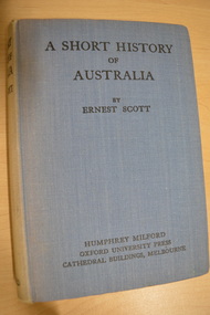 Camberwell Historical Society
Book, Ernest Scott, A Short History of Australia, 1928
398 pages with illustrations and mapscamberwell, australia, history -
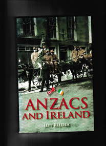 The Celtic Club
Book, Jeff Kildea, Anzacs and Ireland, 2007
This book tells the story of how Irish and Australian soldiers made deep connections as they fought side by side at Gallipoli, the Western Front and Palestine during WW1. Thousands of Irish born men and women enlisted in Australian forces. Many Australians visited Ireland on leave.Index, bib, plates, ill, map, p.231.non-fictionThis book tells the story of how Irish and Australian soldiers made deep connections as they fought side by side at Gallipoli, the Western Front and Palestine during WW1. Thousands of Irish born men and women enlisted in Australian forces. Many Australians visited Ireland on leave.ireland - social conditions., world war 1914-1918 - ireland and australia -
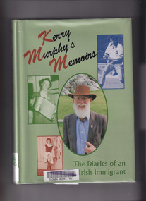 The Celtic Club
Book, Kerry Murphy, Kerry Murphy's Memoirs: The diaries of an Irish immigrant, 1998
Based on meticulously-kept diaries, this book represents a compelling narrative of a man passionate about all things Gaelic - hurling, Gaelic football, language, religion, politics, dance and the celebration of St Patrick's Day.Index, bib., tables, maps, plates. p.320.non-fictionBased on meticulously-kept diaries, this book represents a compelling narrative of a man passionate about all things Gaelic - hurling, Gaelic football, language, religion, politics, dance and the celebration of St Patrick's Day.australia - hstory 1788-1900, convicts - australia -
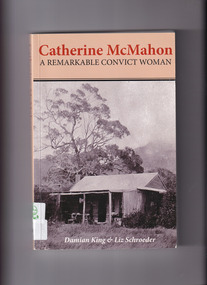 The Celtic Club
Book, Damien King et al, Catherine McMahon: A remarkable convict woman, 2012
Social history of the 18th and 19th century Ireland, England, Van Diemen's Land, Norfolk Island, Victoria and Western Australia via the life story of a woman convict, later free settler of the above named colonies.Index, bib, maps, plates, ill., p.320.non-fictionSocial history of the 18th and 19th century Ireland, England, Van Diemen's Land, Norfolk Island, Victoria and Western Australia via the life story of a woman convict, later free settler of the above named colonies.women convicts - australia -biography., irish - australia -biography -
 The Celtic Club
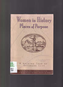
Book, Peg Penberthy, Women in history: Places of purpose, 1994
A collaborative effort between the Australian Institute for Women's Research and Policy and Queensland Historical Association. Includes 'A Walking Tour' of Brisbane city.Maps, plates, ill, bib, p.130.non-fictionA collaborative effort between the Australian Institute for Women's Research and Policy and Queensland Historical Association. Includes 'A Walking Tour' of Brisbane city.brisbane - australia, women - brisbane - history -
 The Celtic Club
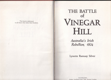
Book, L. R. Silver, The Battle of Vinegar Hill, 1989
An account of an episode which has become part of Australia's legendary past.Index, bib, plates, maps, ill, p.164.non-fictionAn account of an episode which has become part of Australia's legendary past.vinegar hill - insurgency, irish - new south wales - history -
The Celtic Club
Book, Pauline Hamilton, The Irish, 1978
... of a series, 'Making Australian Society'. Index, bib. map. p. 112 ...Written for secondary student use. Part of a series, 'Making Australian Society'.Index, bib. map. p. 112non-fictionWritten for secondary student use. Part of a series, 'Making Australian Society'. -
 The Celtic Club
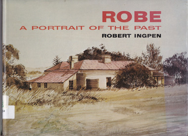
Book, Robert Ingpen, Robe A portrait of the past, 1975
Buildings of historical importance of Robe South Australia are featured in this illustrative work.Plates, ill, maps, p.63.non-fictionBuildings of historical importance of Robe South Australia are featured in this illustrative work.robe (south australia) - history, historical buildings - south australia -
 The Celtic Club
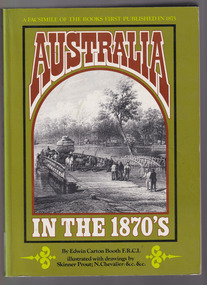
Book, Edwin Carton Booth, Australia in the 1870s, 1975
A facsimile of the original volume. First published 1873-1876 with engravings. There are brief references to aborigines.Maps, ill, facsim, p.232, 2 vols.non-fictionA facsimile of the original volume. First published 1873-1876 with engravings. There are brief references to aborigines.australia - pictorial works, australia - description and travel -
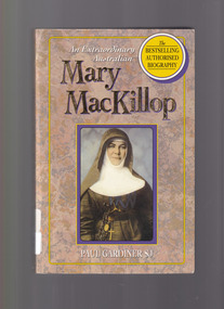 The Celtic Club
Book, Paul Gardiner SJ, An extraordinary Australian: Mary MacKillop, 1994
History of Sisters of Saint Joseph of the Sacred Heart.Index, plates, map, ill, p.486.non-fictionHistory of Sisters of Saint Joseph of the Sacred Heart.mary mckillop - 1842-1909, nuns - aistralia - biography -
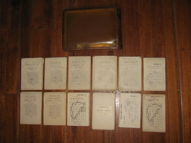 Harcourt Valley Heritage & Tourist Centre
Field maps in case, 1914
Maps used in World War I by Col W E JamesPart of a large collection of items belonging to Col, W E James, of Harcourt, who after a career in the Militia, commanded Australian troops in WW1, both at Gallipoli and on the western Front. The entire collection includes books on military law and maps. Essential part of the commanding officer’s kit. Collection of 12 fold up war maps from Europe used during World War I; on linen backing. Brown leather case, transparent front cover, brass fastenings and loop for attaching to the belt -
 Ringwood RSL Sub-Branch
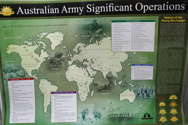
Work on paper - Australian army significant operations map, Memorabilia
... Australian army significant operations map ...World map of operations x 2 -
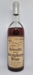 Wodonga & District Historical Society Inc
Functional object - Bottle - Schmidt's Strawberry Wine 1976
Schmidt’s Strawberry Farm is set on acres of lush strawberry fields in Allans Flat, approximately 5 kilometres from Yackandandah and 24 kilometres from Wodonga. Schmidt's is the oldest strawberry winery in Australia, owned and operated by brothers Martin and Michael Schmidt who are third generation strawberry growers/winemakers.This item originates from the oldest strawberry winery in AustraliaA bottle of Schmidt's Strawberry Wine from their 1975 harvest. The bottle bears a beige label with brown text. Their is also a sticker on the back of the bottle containing information about the wine.Front Label below a district map: 1975 Harvest/ Schmidt's /(GENUINE)/ Strawberry/ Wine/ Grown & Bottled by / J.F., D. F. & G. SCHMIDT/ ALLANS FLAT, VICTORIA/ PRODUCT OF AUSTRALIA/ .740 LITRES" On sticker across back: "Fermented from fresh strawberries with no artificial flavour or/ preservatives. This strawberry wine has been the house specialty/ of the Schmidt family for many generations - with the advent of/ improved growing techniques, this dessert wine is now introduced/ to the wine lovers of Australia."strawberry wine, schmidt’s strawberry farm, martin and michael schmidt