Showing 171832 items
matching will street
-
 Whitehorse Historical Society Inc.
Article, Tally Ho moving with the times
Article in 'Wesley in Action' published by Wesley Central Mission about Tally Ho Youth Services who are moving after 83 years.Article in 'Wesley in Action' published by Wesley Central Mission about Tally Ho Youth Services who are moving after 83 years. Includes the history of Tally Ho. Each child will be living in a typical home in a typical suburban street rather than on the campus.Article in 'Wesley in Action' published by Wesley Central Mission about Tally Ho Youth Services who are moving after 83 years. youth services, wesley central mission, cole, george henry, tally ho youth services -
 Yarra Glen & District Historical Society
Black and white photographs, Bell Street Yarra Glen
Photograph taken from the corner of King Street and Bell Streets Yarra Glen with a view of buildings on the western side of Bell Street from Scott & Allen's General Store to the Colonial Bank building. Other buildings include the house of Charles Bath and the Grand Hotel. Tree guards line the street.grand hotel, bell street, tree guards, charles bath, general store, scott allen s general store, colonial bank, bank building, hotels -
 City of Greater Bendigo - Civic Collection
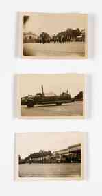
Photograph - Three photographs : Bendigo Easter Fair, c 1938
The Bendigo Easter Fair was established in 1871 to fundraise for the hospital and the Bendigo Benevolent Asylum. These family snap shots were donated by the Sandner family who were long associated with the Bendigo Hospital. Photograph 0319.3 features the Chinese Dragon.Set of three black and white photographs. All photographs are taken on the streets of Bendigo during the Easter fair and parade, year unknown. 0319.1; Marching Brass band on street with crowds on both sides. 0319.2; Street view of parade float. 0319.3 Chinese dragon on street with crowds on both sides. Verso; 0319.1, 0319.2, 0319.3 Handwritten; B 622eugene and mollie sandner collection, bendigo hospital, eugene sandner, mollie sandner, mollie sibson, bendigo easter fair, mayor sandner, mayoress sandner, bendigo chinese dragon -
Port Melbourne Historical & Preservation Society
Plan, Graeme Bentley Pty Ltd, Port Melbourne Foreshore Landscape Master Plan MP2 (A), February 1993
The Port Melbourne Foreshore Landscape Master Plan was created by Landscape Architectural firm of Graeme Bentley Pty Ltd for the City of Port Melbourne. MP2 (A) portrays the section of foreshore from Stokes Street to Dow Street. The plan proposed street tree planting along Beach Street. The plan was not actioned.built environment - recreational facilities, beach street, port melbourne foreshore, station pier -
 Clunes Museum
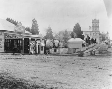
Photograph, C. NETTLETON, FRASER STREET, CLUNES, CIRCA 1866-67
PHOTOGRAPH OF FRASER STREET, FROM CAMP PARADE ABOUT 1866-67. NOTE STATE OF CREEK AND ABSENCE OF BRIDGES.PHOTOGRAPH OF FRASER STREET, CLUNES. TAKEN FROM CAMP PARADE .1 SEPIA PHOTOGRAPH MOUNTED ON CARDBOARD, .2 BLACK AND WHITE PHOTO PRINT .3 BLACK AND WHITE PHOTO PRINT MOUNTED ON CARDBOARD, TITLED CLUNES FROM CAMP PARADE - ABOUT 1865 .4 SEPIA PHOTOGRAPH MOUNTED ON BOARD WITH NOTES OF PLACES OF INTEREST AROUND PHOTO. TITLED FRASER STREET CLUNES. .5 BLACK ANBD WHITE PHOTO PRINT .6 SMALL PHOTO PRINT .7 SMALL PHOTO PRINT WITH DESCRIPTION ON BACK .8 SMALL PHOTO PRINT .9 SEPIA PHOTO PRINT .10 SEPIA PHOTO PRINTFRASER ST. CLUNESlocal history, photography, photographs, clunes township, early fraser street -
 Warrnambool and District Historical Society Inc.
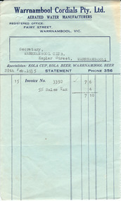
Document, Warrnambool Cordial, 1935
This is a docket issued by Warrnambool Cordials Pty Ltd in 1935 to the Warrnambool Club. Warrnambool Cordials was originally established in the early 1920s by the Lescai Brothers who had their business in Fairy Street. A company of local businessmen took over the cordial factory for some time when the Lescai brothers left the city, then it was purchased by a garage proprietor, Thomas Hill, and in the early 1930s Charles and Frederick Flett purchased the business and carried it on for a few years. It was later operated by Thomas McKenzie before it was closed. It was still operating in 1975 when it was manufacturing Loys and McKenzie’s soft drinks. It is noted that this docket contains the information that the Warrnambool Cordials business was a winner of a Bronze Medal for lemonade at the Royal Show in 1931. The Warrnambool Club, established in 1874 when the Warrnambool Club Hotel in Kepler Street was opened, was a gentleman’s club. A new Warrnambool Club building was erected in Kepler Street in 1877 and is still in use today. This original docket is of interest as an example of the type of purchase made by the Warrnambool Club in 1935 and the type of docket used by the firm of Warrnambool Cordials.This is a docket printed on green paper with blue printed material and blue lines. The details of the sale have been typed. The green paper is discoloured on the right hand side. Typed material: ‘Secretary, Warrnambool Club, Kepler Street, Warrnambool, 28th Feb.1935, 15, Invoice no. 3392, 7/6. 5% Sales Tax, 4, 7/10’warrnambool cordials -
 Kew Historical Society Inc
Photograph - Filling in the Outer Circle Railway cutting at East Kew, 1939
W.D. Vaughan (Kew's Civic Century, 1960, pp.195-6) quotes Council Minutes of 1938 and 1939 to record that: "After protracted negotiations between the Council, the Railways Department and the Tramways Board agreement was reached in June, 1938, for the filling of the railway cutting at the Harp Junction and shifting tram tracks to the High Street alignment ... The Outer Circle railway land from Princess Street to Park Crescent was purchased by the Kew Council in October, 1939, for 2,750 [pounds]. The land from Park Crescent to High Street was leased for 1 [pound] per annum. Considerable work was done in levelling the embankments to the original surface level."Important and rare photograph of the period, showing major works by Kew Council in Kew East working on a significant piece of urban infrastructure.Small, original black and white positive (photograph) showing workers and vehicles filling in the tracks of the former Outer Circle railway at East Kew. In the background is the metal bridge with brick piers, adjacent to the Harp Junction. The bridge crossed the cutting, linking the two parts of High Street. Behind the tip truck, painted on the side with the name 'Fowler Quarries' [located Keilor Road, North Essendon], one can see shops [including T.G. Garroway, Cash Grocer] in High Street. What appears to be the City of Kew Steamroller is immediately in front of the bridge. A group of passers-by watch from the bridge and from the road. Annotation in pencil on verso: "Filling in Outer Circle line at High St East Kew prior to straightening High St. (c. Feb 1930?)outer circle railway, railway cuttings, harp junction, high street -- kew east -
 Ararat & District Historical Society (operating the Langi Morgala Museum)
Barkly Street, Ararat, perhaps 1870s
This is one of a dozen or so pictures of very early Ararat held by Langi Morgala Museum, and can be compared to a succession of later photographs to illustrate the growth of the town of Ararat. The date suggested by the inscription on the front is probably a reference to some other occurrence, since the street seems far to built-up for 1856-1860. The date is more likely the 1870s, or even the 1880sThis photograph, though not in good condition, is one of the few in the possession of Langi Morgala Museum that shows very early Ararat. It is of regional significance, which would be enhanced if a firmer date could be established. This cardboard-mounted large photograph is not in very good condition, but some parts of the image are still clear. There are permanent inscriptions on both front and back, not done in sympathy with the age and importance of the item.On front: "Note hitching posts and the old Turf Hotel, Barkly Street cont[illegible] / 1856-60". On back: museum stamp and photo numbers.barkly-street, ararat, horse, horse-driven, early-ararat, business, commercial -
 Kew Historical Society Inc
Plan, Survey Plan, Park Hill Road, Kew, 1880-1890
The streets identified on the survey plan - Cotham Road, Park Hill Road East, Park Hill Road West in Kew were each gazetted by the Victorian Government in 1865. The hand-coloured survey plan was completed by Holland Loxton, Town Clerk and Surveyor of the Borough of Kew from 1866. The unnamed survey plan includes names of land owners in addition to measurements (2 chains to 1 inch) and streets. Named owners include Webster, Payne and Francom which will enable us to narrow down the creation date of the survey.Handdrawn survey plan by a former surveyor and town clerk of KewHand drawn and coloured survey plan created by Holland Loxton, Surveyor and Town Clerk of Kew, showing land owned by Payne in Park Hill Road, Kew. The plan includes street names, land measurements and land owners.surveys - kew, maps - kew, holland loxton, park hill road - kew, holland loxton -- surveyor, survey plans -- parkhill road -- kew (vic.) -
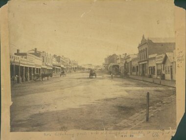
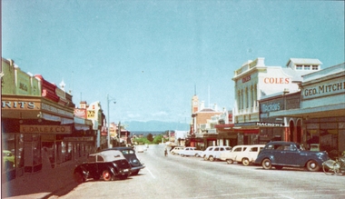 Stawell Historical Society Inc
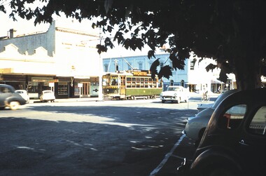
Photograph, Main Street Stawell looking West with Geo. Mitchell shop on the right c 1955 -- Coloured
Coloured photo c 1955 Main Street Scene looking West. Geo Mitchell Draper on right with Coles and Macrows. On the left E. Dale & Co. shop sign is visible. Either side of the street has cars parked at an angle with a soft canopy car parked on the left side.Colour photograph looking down Main St Stawell with the Grampians in the distance c 1955. This coloured photo has shops either side in view and cars parked at an angle along the street. Coles, Macrows and Geo. Mitchell shops are on the right and E. Dale & Co shop sigh is visible on the left.stawell business streetscape -
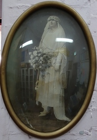 Kew Historical Society Inc
Photograph - Framed Wedding Photograph, Kathleen Cook (nee Currucan), 1923, 1923
The Argus on 15 September 1923 reported: COOK—CARRUCAN.—On the 11th August, at the Sacred Heart Church, Kew, bv the Rev. Father Manley, Reginald Walter, son of Mrs. and the late Charles Cook, of Wellington, Somerset, England, to Kathleen, eldest daughter of Mr. and Mrs. J. Carrucan, Derby street, Kew.The Carrucan family were a notable family in Kew.Oval photograph of a bride in an oval frame with curved glass. The bride is Kathleen Carrucan at her marriage to Reginald Cook in 1923.Inscription on reverse: "Kathleen Cook [nee Carrucan] lived at 129 Derby Street Kew. Jack Carrucan family home. Married 1923 to Reginald Cook". kathleen cook, kathleen carrucan, reginald cook, wedding photograph -
 Glen Eira Historical Society
Railways in Caulfield
Photocopy of Rosstown Sugerworks and railway built in 1876 on corner of what is now Miller Street, Neville Street and Koornang Roadcarnegie, rosstown sugerworks, miller street, neville street, koornang road, railways -
 Glenelg Shire Council Cultural Collection
Photograph - Photograph - St Kilda Road, Melbourne, Esther Winifred Hall, 1934
Photographs taken by Esther Winifred Hall (nee Smallpage) - great grand-daughter of Stephen George Henty. Taken in 1934 Centenary Celebrations in Portland.Black and white sepia photograph of four-storey building at street intersection. Street sign on left "St. Kilda Rd".Front: (no inscriptions) Back: Chevron corner St. Kilda and Commercial Roads Nov: 1934 V. Hursthouse (?)esther winifred hall, henty, 1934 -
 Glenelg Shire Council Cultural Collection
Photograph - Photograph - street scene, Portland, n.d
Photograph showing a street scene. There is a church spire in the background and a group of 3 people crossing the street. There is a monument in the middle of the road. -
 Eltham District Historical Society Inc
Photograph, Street near Eltham
Main Road Eltham looking south from opposite John Street towards Pitt Street showing Eltham Hotelmain road, pitt street, eltham, hotels -
 Ringwood and District Historical Society
Photograph, Rear of schoolmaster's house Ringwood Street, Ringwood, near the corner of Civic Place in 1945, 1945
Rear of schoolmaster's house Ringwood Street, near the corner of Civic Place in 1945 +Additional Keywords: Schools / Ringwood StreetTyped below photograph, "Rear of schoolmaster's house Ringwood St. Cnr. Civic Place, 1945". Written on backing of photograph, "Rear of School Masters House in Ringwood St. c1948 - formerly school ?? Heatherdale Rd." -
 Federation University Historical Collection
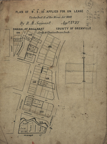
Plan, Lease Applied for by R.M. Serjeant, c1890, c1890
Plan of a lease showing streets around Skipton and Windermere Streets, Redan. Scale 4 chains to 1 inch (!:3168)serjeant, r.m.serjeant, robert m. serjeant, george street, skiptn street, windermere stret, rubicon stret, cobdon street, ascot street, lease, redan, ballarat, robert malachi serjeant, band of hope and albion mine -
 Federation University Historical Collection
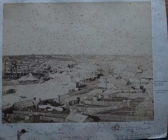
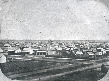
Photograph, Solomon and Bardwell, Ballarat From the Western Fire Brigade Tower Looking South
Black and white photograph of Ballarat taken from the Ballarat West Fire Brigade on the corner of Sturt Street and Raglan Street. ballarat, ballarat west fire brigade, solomon and bardwell -
Port Melbourne Historical & Preservation Society
Photograph - Alterations to Bay Street (one lane each way), Port Melbourne, Ron Laing, 1999 - 2000
Part of Ron Laing's collection of photographs recording Port Melbourne over a thirteen year period. Donated to the PMH&PS by the photographer.A set of nine colour photographs covering the alterations of Bay Street to a one lane each way street, 1999-2000engineering - roads streets lanes and footpaths, ron laing, bay street -
Port Melbourne Historical & Preservation Society
Document, Chain of title for 351 Princes Street, Port Melbourne 1859-2008, 1913 - 1939
Held by Titles Office from 1859 to about 2004. Peter Parrington obtained them after converting title to more common Torrens.Chain of title for 351 Princes Street, Port Melbourne 1859-2008 Conveyance of current 351 Princes Street 28.06.1866built environment - domestic, families, dennis ryan, bridget ryan, ryan, stephen, clark street, princes street, john harbison, margaret ryan, b & j howletti, j anderson, n clelland, p j (peter) parrington, s l (sue) parrington -
Port Melbourne Historical & Preservation Society
Photograph - Bay Street, Port Melbourne, 1990
Photograph was donated to the Society by the photographer Alison KELLY. c1990. It 'duplicates' the 1870s photograph of the same view with Morley's cart.Colour photograph taken at the intersection of Bay and Beach Street Port Melbourne, looking up Bay Street toward the city.built environment, alison kelly, bay street -
 Port Melbourne Historical & Preservation Society
Photograph - Margaret Smith, on bicycle, Princes Street, Port Melbourne, 1940
Small snapshot of Margaret Smith c1948 on bicycle in Princes Street in front of Crichton Reserve, with houses in Stokes Street in the background.built environment - domestic, children, margaret smith -
Port Melbourne Historical & Preservation Society
Plan - Williamstown Road from Salmon Street to Prohasky Street, Engineering Department, Town of Port Melbourne, 1893 - 1919
Plan of Williamstown Road (Reconstruction of pitched portion). From Salmon Street to Prohasky Street. 1893 Loan Number 5.Reverse side - Williamstown Road, west of Salmon (Pitcher Construction).engineering - roads streets lanes and footpaths -
 Port Melbourne Historical & Preservation Society
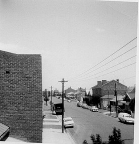
Photograph - Heath Street, Port Melbourne, 1980
B&W photo of Heath Street looking south towards Bridge Street c 1980 (view from rooftop)built environment - domestic, antonio cannatelli, heath street -
Port Melbourne Historical & Preservation Society
Photograph - Former Station Hotel, Bridge and Station Streets, Port Melbourne, David Thompson, 1990s
One of five colour photographs of Port Melbourne streets: Former Station Hotel at Bridge and Station Streets, converted to flats.built environment - commercial, bay street -
 Bendigo Historical Society Inc.
Slide - BENDIGO STREET VIEWS & FORTUNA, Apr 1962
Slide. Bendigo Street Views & Fortuna. A tram travelling along Pall Mall past Bull Street towards the Fountain.slide, bendigo, bendigo street views & fortuna., bendigo street views & fortuna. -
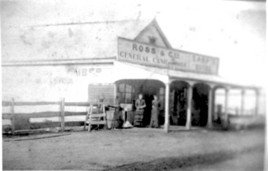 Tatura Irrigation & Wartime Camps Museum
Photograph, Ross' Store c1874
Ross' Store c1874, Ross Street; East side, south of Hogan Street. Features two women posing on verandah.tatura, buildings, historic, costume, female -
 Stawell Historical Society Inc
Photograph, Marnoo Hotel
Marnoo Hotel Newall Street (Formerly Main Street) Marnoo c1910. Building on left is the Hotel Burnt down 1957hotel, marnoo -
Whitehorse Historical Society Inc.
Article, Cost split on street works, 1993
Opposition from residents of Erli Court And Francis Street who will be billed for construction of Bell Street (along with its residents).Opposition from residents of Erli Court And Francis Street who will be billed for construction of Bell Street (along with its residents).Opposition from residents of Erli Court And Francis Street who will be billed for construction of Bell Street (along with its residents).city of nunawading, bell street, blackburn, francis street, blackburn, erli court, blackburn -
 Whitehorse Historical Society Inc.
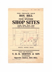
Document, Shop Sites, 1922
Notice of private sale of four shop sitesNotice of private sale of four shop sites in Whitehorse Road, Box Hill between Watt Street and Court Street.Notice of private sale of four shop sitest. r. b. morton & son, whitehorse road, box hill, court street, watt street