Showing 3279 items
matching government local
-
 Brighton Historical Society
Dress, Wedding dress, 1964
... . The reception was held in the Carlton Hotel, Geelong. A longtime local... the OAM in 2007 for "service to local government ...This wedding dress belonged to Rayleen Haig OAM, nee Janetzki, who married Donald Haig in Geelong on 15 August 1964. The dress was designed for Rayleen and made by Deon's of Melbourne, which specialised in wedding gowns (she believes it was above Sportsgirl in Collins Street). It cost about one hundred pounds. The reception was held in the Carlton Hotel, Geelong. A longtime local resident, Rayleen was a Brighton councillor (1983-92) and mayor (1989-90). She was awarded the OAM in 2007 for "service to local government and to the community through health, historical and aged care organisations, particularly within the City of Bayside, and to the National Council of Women of Australia".Cream silk dress with boat neck, short sleeves and back zip. Guipure lace flowers on sleeves and skirt.wedding dress, rayleen haig, rayleen janetzki, donald haig, deon's of melbourne, brighton council, mayor -
 Eltham District Historical Society Inc
Document - Sales Brochure, Dallas Price Homes Pty Ltd, Eltham Hub: A Unique New Entry To Eltham's Town Centre; the facts about this multi purpose development, 1996
... Government commenced to restructure local government in 1994, which... State Government commenced to restructure local government ...Produced by Contour Consultants Australia Pty Ltd on behalf of Dallas Price Homes Pty Ltd as part of the planning process for redevelopment of the former Eltham Shire Office site at 895 Main Road. In 1963 the Shire of Eltham purchased the Shillinglaw property of approximately 2 acres in Main Road, Eltham for the widening of Main Road and as a site for new Council offices. This land, which contained the Shillinglaw Cottage (c1878-80), was the remaining section of the Shillinglaw family holding that originally comprised 30 acres, being Lot 90 of Holloway's 1851 subdivision. Eltham Council intended to demolish this cottage, but through extensive community action it was saved, funds were raised, and it was relocated to the current site adjacent to the Eltham Library. The new Eltham Shire Offices opened in 1965 were designed to ensure retention of the three Italian Cypress trees that were located outside the Shillinglaw Cottage. In 1971 the building was extended at the southern end to provide additional space, including for the Eltham Library and Council's Engineering Department. Renovations were undertaken to the offices during 1987. The Victorian State Government commenced to restructure local government in 1994, which resulted in the establishment of the Shire of Nillumbik and the cessation of the Shire of Eltham. This new Nillumbik Shire Council was headed by government appointed commissioners, who decided in 1995 to put the former Eltham Shire offices on the market. Eventually in June 1996 the property was sold for $1.1 million and the building was subsequently demolished. A planning application for the site was then submitted to Nillumbik Shire Council in September 1996 for construction of a 24-hour service station, convenience store, cafe/takeaway food premises, a retail facility and community facility. There were many objections to this proposed development and in controversial circumstances a planning permit was granted by the Nillumbik Shire Council commissioners. After protracted actions involving a planning panel and a planning advisory committee, established by the Minister for Local Government, the proposal was eventually rejected as not satisfying the requirements of the planning scheme. In December 1997 the purchaser withdrew from the contract of sale, just prior to Council announcing a withdrawal from the contract. While there have been a number of possible development proposals considered by subsequent Nillumbik Shire Councils, this site has remained vacant since July 1996. TIMELINE (Prepared by Jim Connor, Eltham District Historical Society- March 2018- Based on press, council and personal records) June 1996 - Eltham Shire offices sold to Dallas Price Homes for $1.1 million. July 1996 - Shire office building demolished against community's wishes. Council claimed building riddled with asbestos. September 1996 - Planning application submitted to Nillumbik Shire Council to construct on the site a 24 hours Shell service station, convenience store, Hungry Jacks café/takeaway food premises, a retail facility and community facility. 213 objections and petition of over 1400 signatures received. Minister for Planning and Local Government orders an independent investigation into valuation and sale. 9 October 1996 - Permit granted by Nillumbik Shire Council commissioners, in controversial circumstances. A Planning Special Committee consisting of 3 commissioners and 3 community representatives considered 32 community objections. One commissioner declared a potential conflict of interest so only 2 commissioners were able to vote. After hearing all objections, the community representatives moved a foreshadowed motion to refuse a permit. The commissioners then closed the meeting, formerly opened a council meeting (for about a minute) and approved the application. October 1996 - Community members appealed planning decision to Administrative Appeals Tribunal. November 1996 -Minister for Planning and Local Government Robert McClelland calls appeal in and directs MT to refer this 'major policy issue' to the Governor in Council. February 1997 - Planning panel (Dimity Reed and Margaret Pitt) established to consider submissions. March 1997 - New council elected with five councillors. April 1997 - Three of the five new councillors vote to fight Commissioner's decision to grant a permit. April 1997 - Planning panel (Dimity Reed and Margaret Pitt) conducts hearings at Nillumbik Shire offices. June 1997 -Planning panel rejected Dallas Price Homes proposal as being 'totally inappropriate' for the site and recommends the site be rezoned for 'public purposes'. July 1997 - Dallas Price Homes threatened to sue Council and individual councillors. October 1997 - Report released of an Advisory Committee (Paul Jerome) established by the Minister for Planning and Local Government. Committee considered Dallas Price Homes proposal and an alternative concept plan proposal by Council for a gallery, workshop, offices and cinema community-based development. Advisory Committee recommended Dallas Price Homes proposal be rejected as not satisfying the requirements of the planning scheme and recommended further testing of the financial viability of Council's proposal. December 1997 - Dallas Price Homes withdrew from the contract of sale, just prior to Council announcing a withdrawal from the contract, which expired on 28th November and was not renewed by either side, after previously being extended twice pending a decision by the Minister. Council had to pay developer $58,000 for demolition costs. February 1998 - Dallas Price Homes application rejected by Planning and Local Government Minister. October 1998 - Nillumbik Councillors suspended and an Administrator appointed (until March 1999). The demolition of the former Shire of Eltham offices and proposed sale and development driven by the Commissioners for Nillumbik Shire Council brought the community together in substantial protest at the infrigement of ratepayers democratic say in local government and ciommunity assets combined with protests about inappropraite development of Eltham's Gateway. This issue led to the formation of the Eltham Community Action Group which still operates strongly today (2023) on behalf of the community to ensure appropriate development within the community.895 main road, commissioners, dallas price homes, development application, eltham hub, hungry jacks, nillumbik shire council, re-zoning, shell service station, town planning, eltham gateway, eltham gateway action group, eltham shire offices, shillinglaw cottage, shillinglaw farm, shillinglaw trees, jim connor collection -
 Kiewa Valley Historical Society
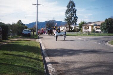
Photographs – Set of 13 colour photographs of spectators preparing for the street parade to celebrate the first Official Hoppet race run at Falls Creek in 1991, 1991
... , local government representatives and individuals...., local government representatives and individuals. Kangaroo ...In 1977 a group of Mount Beauty cross country skiers formed the Birkebeiner Nordic Ski Club. In 1979, a version of the famous Birkebeiner race, the first Australian Birkebeiner was held at Falls Creek. In June 1990 representatives from Australia put their case for a southern hemisphere race in the series. Following a trial event in 1990. Australia became the 12th member of Worldloppet in the winter of 1991, with the first Kangaroo Hoppet. In 1991 a parade and commemorative torch lighting ceremony were organised in Mt Beauty as part of the celebrations to mark the first official Kangaroo Hoppett with participation from local community groups and commercial organisations, the Chamber of Commerce, local government representatives and individuals.Kangaroo Hoppet caters to diverse interests by offering a 42km and 21km event. It also offers a 7km event that attracts skiers, ranging from elite juniors to parents, grandparents, babies and first time skiers. It is recognised on the world cross country ski race calendar. It brings large numbers of participants and spectators to the area which support tourism, local businesses and employment. The 2018 event will be the 28th Kangaroo Hoppet, with cross country skiers travelling from across the country and overseas to compete.Set of 13 colour photographs of spectators lining both sides of Holland St in preparation for the Kangaroo Hoppet street parade. Photographs show the original hospital buildings and street-scape of the early 1990’sNo markingskangaroo hoppet; cross country skiing; ski race; bogong high plains, mt beauty, parade -
 Kiewa Valley Historical Society
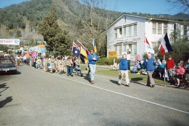
Photographs – Set of 25 colour photographs of the street parade to celebrate the first Official Hoppet race run at Falls Creek in 1991, 1991
... , local government representatives and individuals...., local government representatives and individuals. Kangaroo ...In 1977 a group of Mount Beauty cross country skiers formed the Birkebeiner Nordic Ski Club. In 1979, a version of the famous Birkebeiner race, the first Australian Birkebeiner was held at Falls Creek. In June 1990 representatives from Australia put their case for a southern hemisphere race in the series. Following a trial event in 1990. Australia became the 12th member of Worldloppet in the winter of 1991, with the first Kangaroo Hoppet. In 1991 a parade and commemorative torch lighting ceremony were organised in Mt Beauty as part of the celebrations to mark the first official Kangaroo Hoppett with participation from local community groups and commercial organisations, the Chamber of Commerce, local government representatives and individuals.Kangaroo Hoppet caters to diverse interests by offering a 42km and 21km event. It also offers a 7km event that attracts skiers, ranging from elite juniors to parents, grandparents, babies and first time skiers. It is recognised on the world cross country ski race calendar. It brings large numbers of participants and spectators to the area which support tourism, local businesses and employment. The 2018 event will be the 28th Kangaroo Hoppet, with cross country skiers travelling from across the country and overseas to compete.PHYSICAL: Set of 22 colour photographs of the street parade to celebrate the first Official Hoppet race run at Falls Creek in 1991. Participants from a range of local community groups are traveling along Kiewa Cres. Photos are taken near the corner of Maddison St 1&2 – Horseman & accordion player leading the parade Sign reads ‘Falls Creek The Happy Mountain’ 3-4 Birkbeioner Nordic Ski Club with Chinese Nordic ski representatives 5 & 6- Girl Guides & Brownies 7, 8 & 9- Mt Beauty Primary School & Netball team 10 & 11- UKV Calisthenics Club 12- Lawn Bowls Club 13- Junior Football Club 14- Mt Beauty High School Band (on Wodonga Timber & Hardware truck) 15, 16 17 & 18- Mt Beauty Kindergarten 19,20, 21 & 22- Local Community Vehicles including Community Transport and Fire Brigade 23 & 24- Mt Beauty High School Band 25- Fiat 500 Topolino Vintage Car No markingskangaroo hoppet; cross country skiing; ski race; bogong high plains, mt beauty, parade -
 Kiewa Valley Historical Society
Photographs – Set of 13 colour photographs of the street parade to celebrate the first Official Hoppet race run at Falls Creek in 1991, 1991
... , local government representatives and individuals...., local government representatives and individuals. Kangaroo ...In 1977 a group of Mount Beauty cross country skiers formed the Birkebeiner Nordic Ski Club. In 1979, a version of the famous Birkebeiner race, the first Australian Birkebeiner was held at Falls Creek. In June 1990 representatives from Australia put their case for a southern hemisphere race in the series. Following a trial event in 1990. Australia became the 12th member of Worldloppet in the winter of 1991, with the first Kangaroo Hoppet. In 1991 a parade and commemorative torch lighting ceremony were organised in Mt Beauty as part of the celebrations to mark the first official Kangaroo Hoppett with participation from local community groups and commercial organisations, the Chamber of Commerce, local government representatives and individuals.Kangaroo Hoppet caters to diverse interests by offering a 42km and 21km event. It also offers a 7km event that attracts skiers, ranging from elite juniors to parents, grandparents, babies and first time skiers. It is recognised on the world cross country ski race calendar. It brings large numbers of participants and spectators to the area which support tourism, local businesses and employment. The 2018 event will be the 28th Kangaroo Hoppet, with cross country skiers travelling from across the country and overseas to compete.Set of 13 colour photographs of the street parade to celebrate the first Official Hoppet race run at Falls Creek in 1991. Participants were from a range of local community groups and local industry representatives. Photos were taken on Holland St. opposite the old hospital building. Following the parade, a market stalls were set up on the green outside the Community Centre on Holland St. as part of the Hoppet celebrations. 1 & 2- Boy Scouts and Cubs 3- UKV Lions Club 4 & 5- Local children representing the history and fauna of the High Plains 6- Ambulance Services 7, 8, 9 & 10 – Representatives and equipment from local forestry industry 11- Vintage truck by Vintage Charms Tours providing tours of the local area for visitors 12 & 13- Market stalls set up on the green outside the Community Centre on Holland St. as part of the Hoppet celebrations. kangaroo hoppet; ski race; cross country skiing; bogong high plains, mt beauty, parade, -
 Kiewa Valley Historical Society
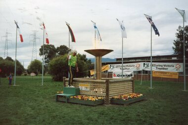
Photographs – Set of 21 colour photographs of the Opening Ceremony and commemorative torch lighting to celebrate the first Official Hoppet race run at Falls Creek in 1991, 1991
... , local government representatives and individuals...., local government representatives and individuals. Kangaroo ...In 1977 a group of Mount Beauty cross country skiers formed the Birkebeiner Nordic Ski Club. In 1979, a version of the famous Birkebeiner race, the first Australian Birkebeiner was held at Falls Creek. In June 1990 representatives from Australia put their case for a southern hemisphere race in the series. Following a trial event in 1990. Australia became the 12th member of Worldloppet in the winter of 1991, with the first Kangaroo Hoppet. In 1991 a parade and commemorative torch lighting ceremony were organised in Mt Beauty as part of the celebrations to mark the first official Kangaroo Hoppett with participation from local community groups and commercial organisations, the Chamber of Commerce, local government representatives and individuals.Kangaroo Hoppet caters to diverse interests by offering a 42km and 21km event. It also offers a 7km event that attracts skiers, ranging from elite juniors to parents, grandparents, babies and first time skiers. It is recognised on the world cross country ski race calendar. It brings large numbers of participants and spectators to the area which support tourism, local businesses and employment. The 2018 event will be the 28th Kangaroo Hoppet, with cross country skiers travelling from across the country and overseas to compete.Set of 21 colour photographs of the Opening Ceremony and Commemorative Torch lighting to celebrate the first Official Hoppet race run at Falls Creek in 1991 1-3 - John Konrads (1956 Olympic Swimmer) lighting the Commemorative Torch with the original torch used at the 1956 Olympics at the MCG in Melbourne. 4-13 – Official opening ceremony and torch lighting by Liberal representative for Indi Mr Lou Leibermann. MC’d by Mr Ken Bell, representing the Chamber of Commerce 14 – Parachute fly over by Mr Ross Schult 15-18 – Photographs of the Multi National flags displayed in the commemorative garden in front of the SECV administration buildings. Flags represent the countries participating in the Kangaroo Hoppet. Snow-capped Mt Bogong in the background. 19-21 – Commemorative torch, erected by SECV to commemorate the first official Kangaroo Hoppet held at Falls Creek. No markingskangaroo hoppet; cross country skiing; ski race; bogong high plains; opening ceremony, mt beauty, parade -
 Surrey Hills Historical Society Collection
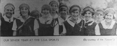
Work on paper - Photograph, Mont Albert Central School Senior Team, December 1927, 1927
... Mont Albert was one of a number of local government schools... of local government schools which provided both primary and some ...Mont Albert was one of a number of local government schools which provided both primary and some secondary education. The term Central School was quite common in Melbourne from at least the 1920's and was used to refer to a school that went up to year 8 or form 2. The reference to the C.S.A. Sports probably refers to the Central Schools Association, or perhaps a shortening of C.S.S.A. (Central Schools Sports Association). A later over-arching association was known as the V.P.S.S.A. (Victorian Primary School Sports Association - now School Sport Victoria.) Mont Albert was frequently mentioned in articles about or results of sporting tournaments, particularly in the Box Hill Reporter.Black and white head and shoulders photo of 10 girls in a uniform of white blouses and a dark tunic. Some are wearing ties. All are wearing head bands. Caption below the photo: "OUR SENIOR TEAM AT THE C.S.A. SPORTS (By courtesy of the "Leader")mont albert central school, sports, central school association, victorian central schools sports association -
 Eltham District Historical Society Inc
Negative - Photograph, George W. Bell, Excavation of site for new Eltham Shire Office building, 895 Main Road, Eltham, 1964
... the Kennett Government amalgamation of local government areas in 1994... the Kennett Government amalgamation of local government areas in 1994 ...Black and white photograph of bulldozer excavating the former Shillinglaw Cottage site for new Shire Offices. 'Shillinglaw Trees' in background. The cottage and land were purchased by the Shire of Eltham as the site for a new shire office building. The cottage was destined for demolition but members of the community concerned at losing one of the areas earliest buildings (built c.1859) initiated a fund-raising campaign to save the cottage. In 1964 the cottage was dis-assembled, all the bricks numbered and reassembled several hundred meters to the south on a site between the Gahan house and the Eltham Railway Trestle Bridge (present-day Panther Place), which became known as the Eltham Common. The new shire offices at 895 Main Road were opened in 1965. Following the Kennett Government amalgamation of local government areas in 1994, the Shire of Eltham ceased to exist, and a new Shire of Nillumbik was created 15 December 1994 from the former Eltham shire and parts of the Diamond Valley shire. The former West Riding which included parts of Montmorency, Lower Plenty and Briar Hill were ceded to the new City of Banyule. Commissioners were appointed for several years and the new Council occupied the former offices of the Shire of Diamond Valley in Greensborough. The former Eltham Shire offices remained vacant until August 1996 the Commissioners suddenly elected to have the former Shire offices demolished immediately and the site has remained vacant ever since. It was not until 1997 before the community was allowed to democratically elect new Councillors to represent them. This photo forms part of a collection of photographs gathered by the Shire of Eltham for their centenary project book,"Pioneers and Painters: 100 years of the Shire of Eltham" by Alan Marshall (1971). The collection of over 500 images is held in partnership between Eltham District Historical Society and Yarra Plenty Regional Library (Eltham Library) and is now formally known as the 'The Shire of Eltham Pioneers Photograph Collection.' It is significant in being the first community sourced collection representing the places and people of the Shire's first one hundred years.Digital image 4 x 5 inch B&W Negeltham, eltham shire office, excavation, george w. bell collection, main road, municipal offices, shillinglaw cottage, shillinglaw trees, shire of eltham pioneers photograph collection, shire offices, significant tree -
 Federation University Historical Collection
Flag - Australian Flag, Red Australian Flag
... use, with State and local governments, private organisations..., with State and local governments, private organisations ...The Australian Red Ensign is a variant flag of Australia. This flag was probably used for a patriotic purpose in Ballarat, such as the end of World War One. The Red Ensign was the only flag private citizens could fly on land. By traditional British understanding, the Blue Ensign was reserved for Commonwealth Government use, with State and local governments, private organisations and individuals all using the Red Ensign.(http://en.wikipedia.org/wiki/Flag_of_Australia) There was some confusion over appropriate use of the ensigns until the Flags Act 1953 set the Blue Ensign as the national flag, and the Red Ensign as the flag of the Australian mercantile marine. Red ensigns continued to be used in Anzac Day marches into the 1960s.(http://en.wikipedia.org/wiki/Flag_of_Australia) Small red paper Australian flag attached to a stick. The Red Ensign features the Commonwealth Star at the hoist, and the Southern Cross in the other half.ballarat, flag, australian ensign, world war, australian flag, red ensign -
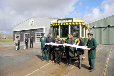 Ballarat Tramway Museum
Photograph - Formal Opening of the new track, Benjamin Boehle-Mitchell, 10-9-2022
... and Local Government 2 - Listening to the speaches. 3 - Trams 13..., Transport, Regional Development and Local Government 2 - Listening ...Digital image by Benjamin Boehle-Mitchell at the time of the launch or opening of the relaid or replaced track in Wendouree Parade and depot extension. Image 1 - Has Sam Boon, Cr Daniel Maloney, BTM President Catherine King MP, Juliana Addison MP and Len Millar - standing in front of tram 13. Catherine King - Minister for Infrastructure, Transport, Regional Development and Local Government 2 - Listening to the speaches. 3 - Trams 13 and 33 at depot junction. 4 - Tram 13 at Carlton St 5 - Trams 13 and 33 at St Aidans Drive 6 - Another group photo - Daniel Maloney, Paul Mong, Catherine King, Peter Waugh and Juliania Addison.Provides information on the people involved at the time of the launch of the new replaced trackwork and the first public services.Set of six Digital Images of the cutting of the ribbon to open the new track and other associated images - 10 September 2022 btm, trackwork, opening, launch, tram 13, museum, depot, wednouree parade -
 Kew Historical Society Inc
Work on paper, Alan Sumner, Preparatory Drawing for 'The Four Seasons' Window, 1985
... the establishment of the Villa Alba Museum, local government, the Kew... the establishment of the Villa Alba Museum, local government, the Kew ...The gouache was presented to Cr Jill O'Brien, Mayor of Kew in 1983-4, who was instrumental in the purchase of the window. The same Kewriosity article, referred to in the physical description, states that the window was originally commissioned from the artist by a Kew timber merchant, and following ownership by successive owners found its way back to Kew. The framed photograph is part of the Jill O'Brien collection which was gifted to the Kew Historical Society following her death in July 2016. The collection includes important primary sources relating to a number of areas in which Jill O'Brien made a significant contribution including the establishment of the Villa Alba Museum, local government, the Kew Historical Society, the Yarra Bend Trust, and the arts.Framed gouache on paper of the design by the artist Alan Sumner for his window, The Four Seasons. The window, now in Kew Library was purchased to commemorate Kew's 125th Anniversary. An article in a contemporary issue of Kewriosity states: The window is approximately three metres in diameter and divided into one central and four outer panels. Clockwise from the top is Autumn with sinuous lines in yellow and brown, then winter in cool blues and mauves with lines and circles suggesting rain, snow and hail. Spring follows in the bottom left quadrant with organic ovaloid shapes richly coloured and lines evoking growth. Then to the top where summer explodes with the colours of fire and blue of the sky at the height of summer. The centre panel has a powerful image of sun, moon and stars which links the surrounding panels".jill o’brien, public art - kew (vic), stained glass - kew (vic), alan sumner - the four seasons, kew library, public art -
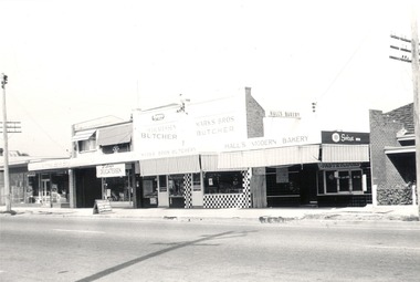 Wodonga & District Historical Society Inc
Photograph - Mann Collection Album - High Street West - S.E.C.; Wodonga Sports Store, Wodonga Delicatessen, Marks Bros. Butchery; Halls Bakery, C. 1970s
... in local government. Bob was also a member of the Bread... also served 9 years in local government. Bob was also a member ...Elaine Mann was married to David Mann, a successful Wodonga businessman and community leader who passed away in Wodonga in June 2012. David was a member of the Mann family who began their business in Wodonga in 1920. Elaine was a teacher in Wodonga for many years and an active member of the community.This photo collection is of significance as it documents how the businesses and buildings in Wodonga have evolved and contributed to community throughout the late 20th century.S.E.C.; Wodonga Sports Store, Wodonga Delicatessen, Marks Bros. Butchery; Halls Bakery. Before Marks Brothers, the butcher Bert Wilcox Butchery. Ron and Anne Chaffey ran the Wodonga Delicatessen from 1983 to 1986 and Marks brothers owned the building. Hall’s Modern Bakery was established in 1930 and was selling Sunicrust Bread. The bakery operated for 48 years. In 1960, Bob Hall and four Albury bakers, Eric Wynne and Allan, Neville and Keith Thiel, joined Bunge’s Albury Flour Mills in forming a new company, Southern Border Bakeries. He became a director and general manager of the company. He also served 9 years in local government. Bob was also a member of the Bread Manufacturers Council of N.S.W., the Australian and New Zealand Bread Manufacturers Association, and an employers representative on the N.S.W. Conciliation Commission and Victorian Arbitration Commission.wodonga businesses, high st wodonga, marks brothers, halls modern bakery -
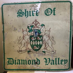 Greensborough Historical Society
Sign - Boundary Sign, Shire of Diamond Valley, Shire of Diamond Valley boundary sign, 1990s
... The Shire of Diamond Valley was a Local Government Area... was a Local Government Area located about 20 kilometres northeast ...The Shire of Diamond Valley was a Local Government Area located about 20 kilometres northeast of Melbourne. The shire covered an area of 74.38 square kilometres and existed from 1964 until 1994. This example of a Boundary Sign was one of many located on the edge of the Shire e.g. at Wattle Glen Station; at Yan Yean Road north of Bannons Lane; 2 on Plenty Road near Larundel and Bundoora Primary School; one on the Para Road bridge; on Wattletree Road Eltham and on Kurrak Road Yarrambat. According to a former Shire employee, the signs were often stolen as quickly as they were replaced. This sign was removed when the Shire of Diamond Valley was dissolved in 1994 and is signed by a Shire employee, giving it strong provenance.Painted metal sign, cream background with green text and Shire of Diamond Valley crest.Inscribed in felt tip pen on back of sign: SDV: from Nov 1964 to 1994. 30 years. Ron Middleton, By-laws Officer and Ranger, from 9/84 to Nov 94 [signed] R. Middletonshire of diamond valley, boundary signs -
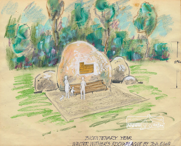 Eltham District Historical Society Inc
Sketch (Concept), Joh Ebeli, Bicentenary Year Walter Withers Rock and Plaque Design by Joh. Ebeli (1988), 1988
... with funds from a local government grant. The initial crane to lift... with funds from a local government grant. The initial crane to lift ...Concept sketch for the placement of a commemorative plaque on a rock in the Walter Wither Reserve at the corner of Arthur and Bible Streets, Eltham. The rock was installed 17 May 1990. Russell Yeoman advised (14 Jun 2017 society meeting) that the Shire of Eltham had been given a plaque to commemorate Walter Withers and that the rock was sourced from west of Melbourne with funds from a local government grant. The initial crane to lift the rock in place was too small and another crane was arranged. This also proved too small to lift it until a third and larger crane was arranged. Mary Owen, granddaughter of Walter Withers unveiled the commemorative plaque at a ceremony held at Walter Withers Reserve at the corner of Bible and Arthur Streets, Eltham, 13 Oct 1990.Colour pencil and wash on paper mounted on card and sealed at edges with masking tape. Protective facing sheet also attached with masking tape."Rock and Plaque design" on facing sheet On back: "John Ebeli 63 Batman Rd Eltham"eltham, walter withers reserve, walter withers rock, shire of eltham, arthur street, bible street, joh ebeli, design, plaques -
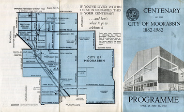 City of Moorabbin Historical Society (Operating the Box Cottage Museum)
Pamphlet - Centenary of the City of Moorabbin 1862 - 1962, Programme April28 - May16, 1962, 1962
... of self local-government. The celebrations commemorated those who... the City of Moorabbin celebrated one hundred years of self local ...In 1962 the City of Moorabbin celebrated one hundred years of self local-government. The celebrations commemorated those who helped form the City of Moorabbin and to recognise their achievements. In May 1862 the Moorabbin district, which included Sandringham, Mentone and Mordialloc was made a Road Board District, on 27 January 1871 it was made a shire and then on 29 November 1934 Moorabbin was proclaimed a City. On 15 December 1994, the City of Moorabbin was abolished, and was split three ways; Bentleigh was transferred into the newly created City of Glen Eira along with the City of Caulfield; Cheltenham was transferred to the newly created City of Bayside, along with the Cities of Brighton and Sandringham; while the bulk of the city merged with the Cities of Mordialloc, Chelsea and parts of Springvale, to become the newly created City of Kingston.A souvenir of the celebration of 100 years of self government by theearly settlers from Moorabbin Roads Board 1862 until City of Moorabbin 1934-62 A tri-fold pamphlet colour print on outside and black and white inside. List of Councillors of City of Moorabbin 1961-1962 - Programme of all the events held to celebrate the Centenary of the City of Moorabbin from April 28 - May 16, 1962Centenary /of the / City of Moorabbin / 1862 -1962city of moorabbin, centenary, celebrations, floats, parade -
 St Kilda Historical Society
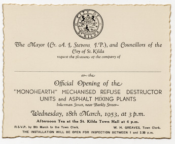
Ephemera - Invitation, Official Opening of the 'Monohearth' Mechanised Refuse Destructo Units and Ashphalt Mixing Plants, 1953
... of the local government amalgamation process combining the former..., as a result of the local government amalgamation process combining ...Invitation to the official opening of refuse destructor units and asphalt mixing plants at Inkerman Street, St Kilda, on 18 March 1953. The destructor units replaced a garbage incinerator that had been operating at the site for thirty years and had become obsolete. They were expected to serve St. Kilda's requirements for the next 80-100 years. In 1994, as a result of the local government amalgamation process combining the former Cities of Port Melbourne, South Melbourne and St Kilda, the new City of Port Phillip owned three municipal depots. The St Kilda municipal depot site became surplus to requirements and, in 1996, the City of Port Phillip resolved to use the site for a community housing project under the City of Port Phillip Housing Program. White card printed in black, with gold jagged edges. Shows St Kilda logo.monohearth, st kilda municipal depot -
 The Beechworth Burke Museum
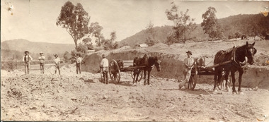
Photograph, Late 1800s
... to surrounding towns. This led to the expansion of the local government... to surrounding towns. This led to the expansion of the local government ...This photograph depicts six men and two horses with carts in the process of constructing a road. The men each stand in a relatively relaxed position, posing for the camera. However, the amount of upturned soil surrounding them suggests the hard work they have endured, armed only with pitchforks and shovels. The creation of new roads in the Beechworth area had become a priority for the Beechworth council in the second half of the nineteenth century. This included connecting roads which radiated out of Beechworth to surrounding towns. This led to the expansion of the local government authority over the surrounding countryside, greatly strengthening Beechworth's central position. The use of horse and cart to take away the removed soil, as well as the style of the men's attire, suggests that this photograph dates back to the late 1800s. It can also be assumed that this photograph was taken somewhere in the surrounding hills of Beechworth. This photograph is historically significant as it provides insight into the rapid expansion of roads in and around Beechworth during the second half of the nineteenth century. Sepia rectangular photograph on matte photographic paper mounted on card Reverse: BMM 2982 / road construction, beechworth roads, 1800s, 1800s beechworth, beechworth hills, horse and cart, beechworth road making, beechworth council roads, road expansion, beechworth surrounding hills -
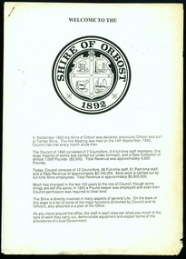
 Orbost & District Historical Society
Invitation, 1969
... , K.C.M.G., M.P. The Shire of Orbost was a local government area..., K.C.M.G., M.P. The Shire of Orbost was a local government area ...The current building was opened on Friday 28th February 1969 by the Premier of Victoria, The Hon. Sir Henry E. Bolte, K.C.M.G., M.P. The Shire of Orbost was a local government area about 380 kilometres east of Melbourne, the state capital of Victoria, Australia. The shire covered an area of 9,347 square kilometres and existed from 1892 until 1994. Originally, Orbost was part of the Bairnsdale Road District which was created on 30 April 1867. Splitting away as part of the Shire of Tambo in 1882, Orbost was first incorporated as a shire in its own right as the Shire of Croajingolong on 30 May 1892. It received its present name on 17 February 1893. On 3 January 1913 part of its western riding was annexed to Tambo as its Cunninghame Riding. Local governments play an important role in the lives of citizens in Australia. Local government authorities exist to provide services and amenities to local communities, and are also responsible for regulating and providing services for land and property in their district. This item is representative of a time when Orbost had its own Shire Council. A stapled program and invitation to the official opening of the new Orbost Shire Council Municipal Offices. A light blue card with the Orbost Shire Council insignia and gold print on front. The invitation is addressed to the secretary of Orbost Historical Society Judith Walcott.handwritten in blue pen - "Judith G Walcott"orbost-shire-council -
 Eltham District Historical Society Inc
Document - Folder, McLure, Mary
... . Kevin Spiller, Montmorency, was honoured for services to local.... Kevin Spiller, Montmorency, was honoured for services to local ...Mary McLure, Roger Green, Arthur Wilson, and Kevin Spiller were awarded Order of Australia Medals in the Queen's Birthday honours list. Mary McLure, Brian Hill, was honoured for her service to the community through volunteer rolls including The Old Colonists' Association of Victoria in St Helena, Rosanna Primary School, and Diamond Creek Craft Group. Roger Green, Lower Plenty, was honoured for his support of war veterans. Arthur Wilson, Greensborough, was honoured for his service to Australian Rules football. Kevin Spiller, Montmorency, was honoured for services to local government. Contents Newspaper article: "Our best get just rewards" Diamond Valley Leader, 19 June 2019, Lists local people who received an OAM in Queen's Birthday honours list. Newspaper clippings, A4 photocopies, etcmary mclure, roger green, arthur wilson, kevin spiller, the old colonists' association of victoria st helena, rosanna primary school, diamond creek craft group -
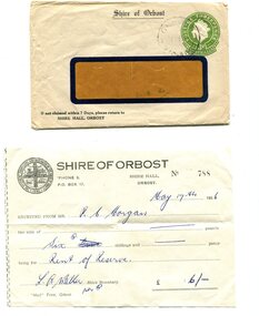 Orbost & District Historical Society
envelope and receipt, Snowy River Mail as "Mail" Print, May 17 1956
... was a local government area about 380 kilometres east of Melbourne... was a local government area about 380 kilometres east of Melbourne ...This receipt was issued to R. C. Morgan of Orbost. on May 17, 1956. It was for rent of reserve for six shillings. It was issued by the Orbost Shire Council. The Shire of Orbost was a local government area about 380 kilometres east of Melbourne, the state capital of Victoria, Australia. The shire covered an area of 9,347 square kilometres and existed from 1892 until 1994. Originally, Orbost was part of the Bairnsdale Road District which was created on 30 April 1867. Splitting away as part of the Shire of Tambo in 1882, Orbost was first incorporated as a shire in its own right as the Shire of Croajingolong on 30 May 1892. It received its present name on 17 February 1893. On 3 January 1913 part of its western riding was annexed to Tambo as its Cunninghame Riding. Local governments play an important role in the lives of citizens in Australia. Local government authorities exist to provide services and amenities to local communities, and are also responsible for regulating and providing services for land and property in their district. This item is representative of a time when Orbost had its own Shire Council. A widow - faced envelope with a green threepence stamp top right corner. At the top is "Shire of Orbost". Bottom right is "If not claimed within 7 Days please return to SHIRE HALL, ORBOST".There is a receipt to R.C. Morgan for 6/- being for the "rent of reserve" and signed by L.A. Walker. It has the Orbost Shire logo in the top left corner.orbost-shire-council morgan-r.c. -
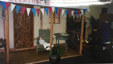 Kew Historical Society Inc
Photograph, Kew Historical Society, Historical Display, Kew Festival, 2001, 2001
... region. For over 60 years, the Society has worked with local.... For over 60 years, the Society has worked with local government ...The Kew Historical Society, founded in 1958, is one of the oldest continuing historical societies in the Greater Melbourne region. For over 60 years, the Society has worked with local government and other community organisations to stimulate interest in Kew’s history and heritage. From its beginnings, the Society held local exhibitions, sometimes in shop windows, on other occasions in civic halls, and now at the Kew Court House and Kew Library. This and other photos taken in the same year are examples of an exhibition in the Phyllis Hore Room at the Kew Library. The modern kew Festival wa initiated in 1974. Initially held every two years, it soon became an annual festival. The Society was a founding participant in the festival, mounting regular displays and participating in marches. In 2001 they mounted a large display in the Phyllis Hore Room of the Kew Library.Photograph of historical items displayed by Kew Historical Society in the Phyllis Hore Room at the Kew Library during the 2001 Kew Festival.kew historical society - exhibitions, kew festival --2001 -
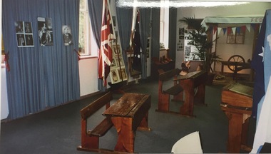 Kew Historical Society Inc
Photograph, Historical Display, Kew Festival, 2001
... region. For over 60 years, the Society has worked with local.... For over 60 years, the Society has worked with local government ...The Kew Historical Society, founded in 1958, is one of the oldest continuing historical societies in the Greater Melbourne region. For over 60 years, the Society has worked with local government and other community organisations to stimulate interest in Kew’s history and heritage. From its beginnings, the Society held local exhibitions, sometimes in shop windows, on other occasions in civic halls, and now at the Kew Court House and Kew Library. This and other photos taken in the same year are examples of an exhibition in the Phyllis Hore Room at the Kew Library. The modern kew Festival wa initiated in 1974. Initially held every two years, it soon became an annual festival. The Society was a founding participant in the festival, mounting regular displays and participating in marches. In 2001 they mounted a large display in the Phyllis Hore Room of the Kew Library.Photograph of historical items displayed by Kew Historical Society in the Phyllis Hore Room at the Kew Library during the 2001 Kew Festival.kew historical society - exhibitions, phyllis hore room, kew library -
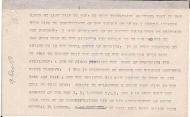 Bendigo Historical Society Inc.
Document - NORMAN OLIVER COLLECTION: SPEECH NOTES 9 DECEMBER 1950
... for Bendigo public works, Local Government Conference, taxis..., Local Government Conference, taxis, the visit of the Chief ...The Norman Oliver collection. Norman Oliver was three times Mayor of Bendigo - 1950-51, 1964-65, 1970-71. Fifteen pages, all but one typed in upper case. The pages are not numbered in sequence. Held together with a paper clip. In the format he used for his talks on 3BO 'The Mayor Speaks'. Topics include : Grants for Bendigo public works, Local Government Conference, taxis, the visit of the Chief Secretary for the Bendigo Cup, and Oliver's comments on the Melbourne play 'The Highwayman', set in Bendigo. Other names include Hon. J. H. Lienhop M.L.C., Mr Smithers, Mr Forrestal, Mr Strom, Mr Harold Alexander (South Melbourne Town clerk), Mr Calwell M.H.R., Mr Menzies, Mr Matthews, Hon.Cr. L. W. Galvin M.L.A., Mr Ted Mullett (Yarra Yarra tribe), Mr r. K. Dodgson M.L.A., Hon. Paul Jones M.L.C., Judge Norris,bendigo, council, speech notes, norman joseph oliver , councillor norman oliver. 3bo 'the mayor speaks'. -
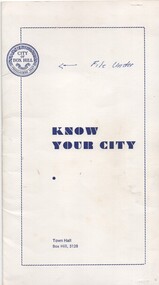 Melbourne Tram Museum
Pamphlet, City of Box Hill, "Know Your City", 1969 to 1973
... edition 9/71 .5 - Local Government in Box Hill - 4th Edition 10... - The Woodhouse Grove Methodist Church - 2nd edition 9/71 .5 - Local ...Set of five pamphlets titled "Know your City", issued early 1970's by the City of Box Hill contained with a white card folder. .1 - white card folder stapled on the right hand edge to contain the pamphlets with the City logo - dated 11/73 .2 - No. 1 - the Box Hill - Doncaster Tram - 3rd edition - 9/69 - see Reg Item 869 for a later version. .3 - No. 2 - The White Horse - 4th edition 12/73 .4 - The Woodhouse Grove Methodist Church - 2nd edition 9/71 .5 - Local Government in Box Hill - 4th Edition 10/73 .6 - Historical Dates - 2nd edition - 5/72 .7 - City of Box Hill - 1973-1974 - folded sheet detailing the activities of the City, budgets and a message from the Mayor. See Reg Item 2534 for an A3 and larger version of .2..1 - has noted "File Under" written in ink on front cover.trams, tramways, box hill, doncaster -
 Orbost & District Historical Society
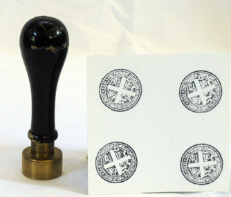
Council Seal
... of local government reform to become part of the newly constituted... of local government reform to become part of the newly constituted ...This item was used as a seal (stamp) on official Shire Council documents. The coat of arms of the Shire of Orbost was designed in the form of a cross in which five stars are depicted on a shield. A small crown above the cross indicates the loyalty of the president,councillors and ratepayers to the reigning monarch. The inner section of the shield contains 4 figures, a sheaf of wheat, a factory, a co and a ship - all representing the activities of agriculture, fishing,industry and dairying undertaken in the shire. Originally part of the Bairnsdale district, Orbost split away as part of the Tambo Shire in 1882, and became a shire in its own right as the Shire of Croajingolong on 30th May,1892. The name was changed to the Shire of Orbost on 17th February, 1893. The Orbost Shire Council was abolished on 2nd December, 1994 as part of a state-wide program of local government reform to become part of the newly constituted East Gippsland Shire council.Local governments play an important role in the lives of citizens in Australia. Local government authorities exist to provide services and amenities to local communities, and are also responsible for regulating and providing services for land and property in their district. This item is representative of a time when Orbost had its own Shire Council.The former Orbost Shire Council Seal (stamp) depicting the coat of arms. The circular seal is brass and has a wooden handle with a bulb shaped top.President, Councillors and Ratepayers of the Shire of Orbost-1892orbost orbost-shire-council government history seal -
 Orbost & District Historical Society
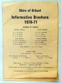
brochures, Snowy River Mail as "Mail" Print, Shire of Orbost Information Brochure, December 1970
... The Shire of Orbost was a local government area about 380... gippsland The Shire of Orbost was a local government area about 380 ...The Shire of Orbost was a local government area about 380 kilometres east of Melbourne, the state capital of Victoria, Australia. The shire covered an area of 9,347 square kilometres ), and existed from 1892 until 1994. Originally, Orbost was part of the Bairnsdale Road District which was created on 30 April 1867. Splitting away as part of the Shire of Tambo in 1882, Orbost was first incorporated as a shire in its own right as the Shire of Croajingolong on 30 May 1892. It received its present name on 17 February 1893. On 3 January 1913 part of its western riding was annexed to Tambo as its Cunninghame Riding. On 2 December 1994, the Shire was abolished, and merged with City and Shire of Bairnsdale, Shire of Tambo, most of Shire of Omeo and the Boole Boole Peninsula from Shire of Rosedale into the Shire of East Gippsland This is a useful research tool.Two copies of a triple fold paper brochure. It is titled"Shire of Orbost Information Brochure" in black print. It contains the names of councillors, staff, the work program and budget.shire-of-orbost -
 Orbost & District Historical Society
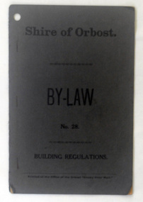
booklet, Snowy River Mail, Shire of Orbost By Laws No 28, 1920's
... regulations. The Shire of Orbost was a local government area about 380... regulations. The Shire of Orbost was a local government area about 380 ...This booklet contains by law No 28 pertaining to building regulations. The Shire of Orbost was a local government area about 380 kilometres east of Melbourne, the state capital of Victoria, Australia. The shire covered an area of 9,347 square kilometres ), and existed from 1892 until 1994. Originally, Orbost was part of the Bairnsdale Road District which was created on 30 April 1867. Splitting away as part of the Shire of Tambo in 1882, Orbost was first incorporated as a shire in its own right as the Shire of Croajingolong on 30 May 1892. It received its present name on 17 February 1893. On 3 January 1913 part of its western riding was annexed to Tambo as its Cunninghame Riding. On 2 December 1994, the Shire was abolished, and merged with City and Shire of Bairnsdale, Shire of Tambo, most of Shire of Omeo and the Boole Boole Peninsula from Shire of Rosedale into the Shire of East Gippsland. This item is a useful research tool.A dark grey, stapled, paper covered booklet with title "Shire of Orbost By Law No 28" in black print. -
 Orbost & District Historical Society
information sheet, Welcome to the Shire of Orbost, 1992
... year. The Shire of Orbost was a local government area about 380... in the centenary year. The Shire of Orbost was a local government area ...This was possibly produced for an open day in the centenary year. The Shire of Orbost was a local government area about 380 kilometres east of Melbourne. The shire covered an area of 9,347 square kilometres and existed from 1892 until 1994. Originally, Orbost was part of the Bairnsdale Road District which was created on 30 April 1867. Splitting away as part of the Shire of Tambo in 1882, Orbost was first incorporated as a shire in its own right as the Shire of Croajingolong on 30 May 1892. It received its present name on 17 February 1893. On 3 January 1913 part of its western riding was annexed to Tambo as its Cunninghame Riding. On 2 December 1994, the Shire was abolished, and merged with City and Shire of Bairnsdale, Shire of Tambo, most of the Shire of Omeo and the Boole Boole Peninsula from Shire of Rosedale into the Shire of East Gippsland. This is a useful reference tool.Two stapled pages of printed information. On the front page is the logo of Orbost Shire Council. There is information on the role of the Shire Councillors for 1992/93. It has a map of the council building.orbost-shire-council -
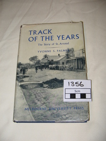 St Arnaud and District Historical Society
Book. Track of the Years, Track Of The Years. The Story of St.Arnaud.By Yvonne S Palmer
... at Work 1861- 1870, Local Government in the District. 1861-1870... at Work 1861- 1870, Local Government in the District. 1861-1870 ...TRACK OF THE YEARS. The Story of St.Arnaud by Yvonne S Palmer had aroused local interest when this book was presented in 1955.The fortunes of this prosperous community, whose origins go back to the excitement of of the New Bendigo gold-rush, gleaned from an unusual wealth of reminiscences,diaries, letters, newspapers and photograph albums, are now placed permanently on record in this fascinating narrative. Contents: The New Bendigo Goldrush, Pastoral Settlement, The Aborigines of the Eastern Wimmera, A Permanent Goldrush, The Township Surveyed, Councils at Work 1861- 1870, Local Government in the District. 1861-1870. Sons of the Antipodes, Diggers in Townsmen, Daughters and Wives, Companies and Miners, Mining Settlements, Increasing Needs, Not by Bread Alone, The beginning of Farming, The Changing Countryside, A New St.Arnaud has Come, Deep Sinking and Dividends, Fewer farmers- Larger farms, Pride but not Complacency.Track of The Years by Yvonne S. Palmer. The Story of St.Arnaud. Hardcover book, blue cover with black and white photograph on the dustcover.Includes photographs and maps.308 pages, 1st Edition.1st Edition Published by Melbourne University Press in 1955. 308 pages. -
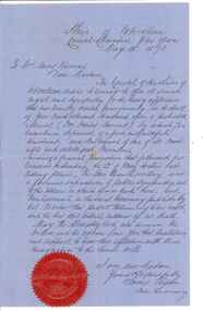 City of Whittlesea
Document - Correspondence, Council letter to Mrs Moses Thomas 1868, 1878
... Boards were one of the earliest forms of local government... Boards were one of the earliest forms of local government ...In 1851 Moses Thomas purchased 400 acres, including a half mile frontage to the Plenty River, at Mernda (then known as Morang) where he operated a farm, inn and other business. In 1865 Moses Thomas was appointed Engineer, Clerk and Collector for the Morang District Road Board. In this role he would have been responsible for overseeing the collection of local property rates and the maintenance and construction of local roads and drains. Road District Boards were one of the earliest forms of local government in Victoria. The Morang or Upper Plenty Road District was established in 1862. It covered part of what is today Mernda, Doreen, South Morang, Mill Park and Bundoora. In 1875, the area merged with the Whittlesea Road District to form the Shire of Whittlesea. Moses Thomas briefly served as a Councillor with the Shire of Whittlesea until his death in 1878. Correspondence. Letter, paper, handwritten text with seal. Letter from James Ryan, Shire Secretary, Shire of Whittlesea to Mrs Moses Thomas on the death of Moses 18 May 1878.