Showing 110202 items matching "roads"
-
 Whitehorse Historical Society Inc.
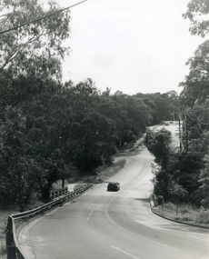
Photograph, Deep Creek Road, Mitcham, 1/01/2001 12:00:00 AM
Black and white photograph of Deep Creek Road, Mitcham taken from lower entrance of Schwerkolt Cottage Reserve showing Glenvale Road on left. Photo taken before work started on new road and bridge.deep creek road, mitcham, glenvale road, ringwood -
 Whitehorse Historical Society Inc.
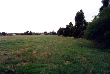
Photograph - Coloured photograph, Narmara Primary School, 13/01/1994 12:00:00 AM
Coloured photo of Narmara Primary School Site, looking East from South East corner. North side of Highbury Road between Middleborough Road and Blackburn Road. Since demolished and site developed for housing.narmara primary school, warner, philip -
 Whitehorse Historical Society Inc.
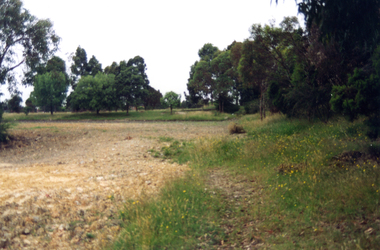
Photograph - Coloured photograph, Narmara Primary School, 13/01/1994 12:00:00 AM
Coloured photo of Narmara Primary School, looking South from North West corner. School on North side of Highbury Road between Middleborough Road and Blackburn Road. Since demolished and site developed for housing.narmara primary school, warner, philip -
 Geelong Cycling Club
Shield
Indicates the boom time experienced for Junior Cyclists at the Geelong Cycling Club during the years 1996-2006 This shield has an important place in the history of juniors in road cycling in Geelong.A mahogany coloured wooden shield with brass plated plaques containing inscriptions of winners of the junior road aggregate of the Geelong West Cycling Club during the years 1996-2006. There is an emblem of a cyclist and a banner at the top centre of the shield. "Geelong West Cycling Club/1996/Tim Wilson/1997/Andrew Tivendale/1998/Christopher Fry/1999/Mark Hudgell/2000/Rohan Chisholm/2001/James Stewart/2002 Danielle Budgell/2003 Brittany Foster/2004/ Chesney Milne/2005 Chesney Milne/Sponsored by/Junior Road Aggregate/Bill Clifton"geelong west cycling club; tim wilson; andrew tivendale; christopher fry; mark hudgell; rohan chisholm; james stewart; danielle budgell; brittany foster; chesney milne; chesney milne; junior road aggregate; bill clifton; -
 Whitehorse Historical Society Inc.
Map, Parish of Nunawading, 1927
Map of the Parish together with part of the Borough of Box Hill.Map of the Parish together with part of the Borough of Box Hill. Includes names of lease or license holders, sizes of leases and in some areas dates of leases. Roads, railway and stations marked. Original survey by W.J.Busocon, 1915. Manuscript note: 15.2.1927 Verified Dept. Lands and Survey.Map of the Parish together with part of the Borough of Box Hill. maps, parish of nunawading, borough of box hill -
 City of Kingston
Pamphlet - Colour, J. F. Brady, Matthiesson's Estate, Highett, c. 1905
Sales plan for land in the suburb of Highett, bounded by Tennyson Street, James Street and Point Nepean Road and including Maher Street, Connors Street, Enright Street, Edward Street, James Street and Matthieson Street.The developing urban area of Highett within the City of Kingston. This land sale pamphlet illustrates the subdivision of land within the municipality and the changing demographic of the district as new houses are constructed close to infrastructure.Colour pamphlet advertising for private sale subdivisions in the Matthiesson's Estate, Highett. Incorporates a map of the estate bordered by Tennyson Street, James Street and Point Nepean Road and including Maher Street, Connors Street, Enright Street, Edward Street, James Street and Matthieson Street.Handwritten in blue pencil: x marked on every subdivision on the map Handwritten in grey pencil at the end of the Price List: x not sold Handwritten in grey pencil adjacent to subdivisions 58, 167 and 166: JP. Turner Handwritten in grey pencil adjacent to subdivision 164: [indecipherable] Markings in grey pencil around the edges of the subdivision map Handwritten in grey pencil on reverse: Matthiesson / Matthiesson Estate / Matthiesson Estateland sales, estate, highett -
 St Kilda Historical Society
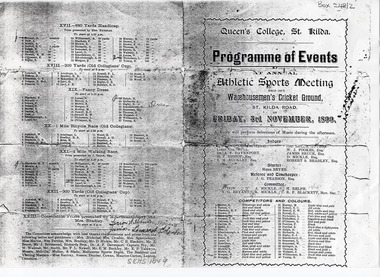
Programme - Sports event program, Program of Events at Annual Athletic Sports Meeting, 1899
Queen's College St Kilda was a private boy's school established by Robert Silby Bradley in 1879. The Warehousemen's Cricket Ground is now known as the Albert Cricket Ground and is operated by the Melbourne Cricket Club. It is located between St Kilda Road and Queens Road.Black and white photocopy of folded programme, 4p. Queen's College, St Kilda. Programme of Events at Annual Athletic Sports Meeting held at Warehousemen's Cricket Ground, St Kilda road, Friday, 3rd November, 1899. A band will perform Selections of Music during the afternoon. Lists the judges, officials, competitors and sponsors and the program of events. Some illegible handwritten comments on final page.queen's college st kilda, warehousemen's cricket ground, st kilda - history -
 Melbourne Tram Museum
Photograph - Four color slides - tram W2 412 and tour ticket, 9-8-1970
Set of four colour slides taken during the Monash Railway club tour on 9-8-1970 using W2 412. The route number and destinations are for show only. Photography by Warren Doubleday. Ticket - No. 0004, printed on yellow card detailing the event. Date stamped on the rear using and Edmondson ticket dater.Yields information on Monash Railway club tour, the trams used, the ticket and the locations.Set of four Anscochrome colour slides, of Melbourne tram W2 412 on a Monash Railway Club tour - 9-8-1970 .1 - Shuntiing at Leura Grove Crossover in Burke Road .2 - Shunting at the crossover in Riversdale Road, near Glenferrie Road .3 - at the Burwood terminus .4 - Outside 412 Toorak Road. Since changed to 1412 Toorak Road .5 - Edmondson style ticket for the tourHas photographers slide numbers on each slide.monash railway club, w2 class, tram 412, toorak road, burwood, burke road, riversdale road, trams, tramways, tickets, edmondson tickets -
 Surrey Hills Historical Society Collection
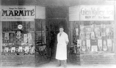
Photograph, Edward Blanchford Wright's grocery shop, Canterbury Road, Surrey Hills
Edward Blatchford Wright was born in 1894 in Birmingham, son of Edward Wright and Florence Emuss. It is not known when he migrated to Australia but he served in the AIF during WW1, seeing action in France. On enlistment aged 20 years 9 months, he gave his occupation as farmer. He married Gertrude Matilda Wain in 1919. He came to Surrey Hills c1924. He was a grocer in the area for several decades with shops in Canterbury Road. In 1942 he is listed at 235 Union Road. This was a residential address. Alan Holt's Surrey Hills property register places him at 365 Canterbury Road (c1920-1930) and 359 Canterbury Road (c1930-1940). He died in 1972 in Mont Albert. His last electoral roll entry in 1968 gives 18 Serpentine Street, Mont Albert. He and his wife are buried in Burwood Cemetery.Black and white photo of the exterior of Edward Blanchford Wright's grocery shop in Canterbury Road, Surrey Hills. The screen door is open and William Reynolds stands in the opening, dressed in a long white coat. The window displays are stacked high with cans and packages and large signs advertising the prices of goods. There is advertising on the windows for Marmite, Glen Valley tea, Preservene soap and Brockoff's biscuits. advertising, shops, grocers, businesses, union road shops, edward blatchford wright, william reynolds, burwood cemetery, world war 1, canterbury road -
 Geelong Cycling Club
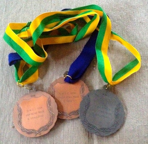
Medals, 1994
Medals were presented by the Geelong West Cycling Club until the year 2002. Medals are a recognition of achievement in competitive cycling events.Medals are a recognition of achievement in competitive cycling events.3 x Medals - two in bronze metal conglomerate, one in silver metal conglomerate. The front of the medals depict an olive wreath around the circumference, and has a racing cyclist painted on an enamel disk in the centre. On the reverse sides, inscriptions appear inside an olive wreath decoration. Each medal has a ribbon attached to it. Medal 1 - "GWCC 1995/Junior Road Race/P. Gage" Medal 2 - "GWCC 1994/Junior Road Race/G. Spaulding" Medal 3 - "GWCC 1994/Junior Road Race/P. McElhinney"medals; gwcc; junior road race; p. gage; p. mcelhinney; g. spaulding; -
 Kew Historical Society Inc
Photograph - Civic event in Stradbroke Park, 1976
Stradbroke Park. Extent: Kilby Road to Harp Road at Burke Road. Historical Documentation: 1851 - Portion 91 purchased by Edward Glynn; 1888 - The Harp of Erin Estate (which included Section 91) offered for sale; 1896 - The area now known as Stradbroke Park was bisected by a creek that flowed from the Yarra via Hay's Paddock (q.v.) and extended through to Burke Road; 1943 - W.D. Birrell, Town Clerk of Kew, proposed that the creek be filled and a reserve created; 1954 - Entire area designated as 'open space' and named 'Stradbroke Park'. The line of the creek that ran through the Park created a further reserve on the north side of High Street, now known as 'Harrison Reserve'. Existing Condition: The park is largely of mown grass that has mature trees set into it It is possible that a number of these are remnant of the original vegetation, while there are also a number of exotic trees introduced, particularly at the northern end of the park. The southern end is dominated by playing fields. (Source: Sanderson, P 1988. Kew Conservation Study)Colour photographic positive (with colour degradation) of sporting teams at a civic event in Stradbroke Park in Kew East in May 1976. The event was officiated by the Mayor of Kew, Cr Alan Hutchinson. Sporting teams in uniform included: footballers, athletes, cricketers, hockey players. Stradbroke Park is situated on the western boundary of Kew at Burke and Harp Roads.stradbroke park, cr alan hutchinson, team sports -- kew (vic.) -
 Surrey Hills Historical Society Collection
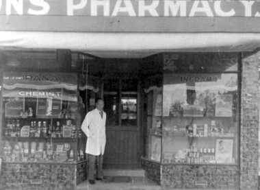
Photograph - Photograph (Copy), Charles Leslie Mitton's Surrey Hills pharmacy, c1933
REF: SHNN article Oct/Nov 1991: Pharmacy was purchased from Mr Nye by C L Mitton in 1933; later moved to 139 Union Road. Research: Stanley Morris Nye (born Ballarat in 1889, son of a Methodist minister; served AIF in WW1) moved to Surrey Hills from Auburn after 1922. He was the first occupant of 131 Union Road which was built in 1924. He is listed in the 1924,1927 and 1931 electoral rolls at 86 Canterbury Road, Surrey Hills. He died aged 44 years in December 1933 and Charles Leslie Mitton took over the business. Charles Leslie Mitton was practising in Newmarket prior to taking over the pharmacy in 1933, the year he also married Ethel Sylvia Stevenson. They lived at 65 Union Road until c1940 when they moved to Kenmare Street, Box Hill North. The pharmacy passed to his son John and daughter Rosalind Lorraine (1937-1997)Black & white photo of a man in a white coat, identified as Charles Leslie Mitton, standing outside his pharmacy in Union Road, Surrey Hills. There is a step up to a central door with glass panels in the top half. The display windows are angled to either side of the door. Within these are shelves displaying many products. The surrounds of the windows are tiled.Note sign for Ipana toothpaste.mitton's pharmacy, businesses, pharmacies, pharmacists, union road shops, mr charles leslie mitton, mr stanley morris nye -
Whitehorse Historical Society Inc.
Legal record - Land Title, Moffatt land, 1925
Certificate of Title Vol.5039 Fol. 703 29 September 1925.Certificate of Title Vol.5039 Fol. 703 29 September 1925, 2 acres 2 roods and 13 perches, bakers Road Blackburn, from William James Moffatt to Edith Sarah Moffatt, 6 September 1946 and Arthur Vernon Moffatt 6 September 1946Certificate of Title Vol.5039 Fol. 703 29 September 1925.moffatt, william james, moffatt, edith sarah, moffatt, arthur vernon, bakers road blackburn -
 Chelsea & District Historical Society Inc
Photograph - South Yarra Post Office
Mr Alfred Morton with his sisters, brothers and friends camping at Carrum in the 1890's. This area was later called Chelsea. Alfred Louis Morton (known as Louis) was born in Geelong in 1866, the fifth of eleven children of Mark Morton and Eliza nee Heard (married 1898). Alfred began work for the Post Office at South Yarra in the 1890s. In the late 1800s it was common for people from Melbourne and north of the city to travel to Chelsea area beaches for their holidays and many liked the area so much that, like the Mortons, they moved here permanently. In the 1890s Alfred’s sister, Mrs William Ashmore, built a weekend house at the foot of what is now Foy Avenue in Chelsea. The Morton family, including Alfred, visited the area often, camping on the foreshore during the 1890s. In 1911 Alfred moved his family permanently to a house on the corner of Morton Grove and Main Road Chelsea (now known as the Nepean Highway) on property that extended from the main road to the beach. This house was destroyed in the fire of 22 December 1913 which raged amongst the ti-tree on the foreshore between Aspendale and Chelsea. Many buildings were destroyed in this fire. The Argus newspaper reported on Wednesday 24 December that 94 houses were burnt with glowing embers blown a mile and half inland. According to the Argus but for the wide break provided by the Point Nepean Road (now the Nepean Highway) and the railway line, the scrub on the other side might have caught. The Morton children, Elsa and Ivan, attended Chelsea State School (now Chelsea Primary School) and Mrs Morton was active in the establishment of St Chad’s Church of England in Chelsea. At the age of 80 in 1945 Mr Morton was concerned about reports that English children had lost their toys due to the war and so he made (as part of a wider effort in Australia) 100 toy engines that were sent to England. He died in 1946 in Chelsea.Sepia photo of South Yarra Post Office, corner of Toorak Road and Osborne Street, South Yarra. Mr Morton and three other postal workers are standing at the front.morton, chelsea, carrum, post office, south yarra, postal workers, postal uniform -
 Eltham District Historical Society Inc
Photograph, R.H. Luxmoore, Painting, 'The Hawthorns', R.H. Luxmoore, 1919, 2/2/19
Situated at the north corner of Main Road and John Street, Eltham; 'The Hawthorns' was the home of T.N. Jewell and his wife, 'Polly' Margaret Jewell (nee White). Painted by R.H. Luxmoore a boarder at the house. Polly Jewell was the aunt of current painting owner (Keith Johnson). Doug Orford's mother would visit her at the home every week.Located on the north corner of Main Road and John Street, Eltham; 'The Hawthorns' was the home of T.N. Jewell and his wife, 'Polly' Margaret White. Most likely viewed from location of where Methodist Church Hall was situated.eltham, the hawthorns, main road, john street, t.n jewell, polly margaret white, r.h luxmoore -
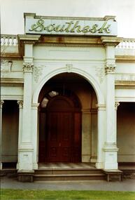 Kew Historical Society Inc
Photograph, Entrance to ‘Southesk’, Cotham Road, 1970
Colour enlargement of a photograph (slide) of Southesk (formerly Ordsall) in Cotham Road, Kew (demolished 1970).Rare colour photograph of the exterior of SoutheskA colour enlargement of the entrance to ‘Southesk’. Formerly known as ‘Ordsall’, the house was built for John Halfey in 1882 on the corner of Cotham Road and Charles Street. This Italianate mansion was built in the Renaissance villa style on a bluestone plinth. The picture provides photographic evidence of the tiling on the veranda and the typically arched doorway. The neon sign above the door was added during the period when it was owned by the City of Kew (1948-70).david carnegie, john halfey, southesk - cotham road - kew (vic), ordsall - cotham road - kew (vic) -
 Eltham District Historical Society Inc
Photograph, Fountain Hotel, Main Road, Eltham
Digitised from scanned print of original postcard of Fountain Hotel, Main Road Eltham (later Evelyn Hotel) early view showing two storey section. Built in 1852 as the Fountain of Friendship Hotel, later named the Fountain Hotel in the 1880s. Located on the southwest corner of Maria (Main) and Pitt streets. Later known as the Evelyn or Evelyn Arms Hotel, it was de-licensed in 1919. The hotel was totally destroyed by fire on Wednesday, February 18, 1931Digital file scan of photo print copy and photocopy of original image of Fountain Hotel, Main Road Eltham (later Evelyn Hotel) early view showing two storey sectionhotels, eltham, fountain hotel, evelyn hotel, main road, pitt street -
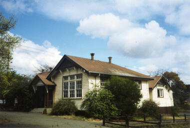 Whitehorse Historical Society Inc.
Photograph, Vermont Primary School No 3133, 1980's
The first of the Vermont Primary School buildings was erected on 1872. In 1907 a room was built onto the west side of the building and a new classroom and cloakroom were erected in 1922. Due to rising numbers and traffic volume, Vermont Progress Association urged the government to relocate the school buildings to a less prominent site, and new school buildings were erected in Nurlendi Street in the 1950's. The original timber building remained on the site until its removal to the Nurlendi Street site in the 1990's, and is on the city of Whitehorse Heritage Review.Coloured photograph of the Vermont Primary School while it was standing vacant from the 1950's until 1989 when it was moved to the main school in Nurlendi Road, Vermont. The school was on the North West corner of Canterbury and Mitcham roads facing Mitcham Road. Canterbury Road can be seen through the trees at the left of the photograph.vermont primary school no 3133, primary schools -
 Eltham District Historical Society Inc
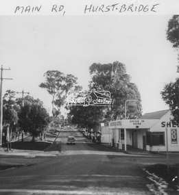
Photograph, Marian Mitchell (nee Robinson), Main Road, Hurstbridge, 7 Aug 1971
Apparently the garage belonged to Peter Brock’s family for which it was locally known and referred to as “Brock’s Garage”."Main Road Hurstbridge" on front On reverse of image: Hurstbridge Main Road Aug 7 1971 Taken by Narian Mitchell (nee Robinson)"fc holden station sedan, hurstbridge, hurstbridge motors, main road, shell service station, peter brock, brock's garage -
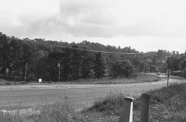 Ringwood and District Historical Society
Photograph, Warrandyte Road looking west from intersection with Old Warrandyte Road and Tortice Drive 1981
Written on back of photograph, "19/7/81. Warrandyte Road looking west from intersection with Old Warrandyte Road and Tortice Drive." -
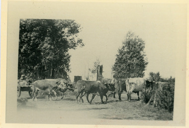 Mt Dandenong & District Historical Society Inc.
Photograph, Sim Kent's Bullocks at Coonara Springs, 1911, 1911
Photograph showing Sim Kent's bullocks at Coonara Springs in 1911. The descriptive text on the reverse of this photograph was hand written by John Lundy-Clarke. 1911 Sim Kent’s bullock team turning into their home paddock in Mernda Road at Coonara Springs after which the road is now named. sim kent, bullocks, coonara springs, mernda road, coonara road, olinda -
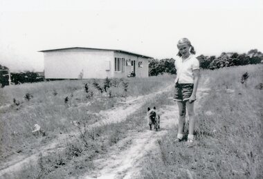 Park Orchards Community House
Photograph, 121 Arundel Road, Park Orchards property in summer 1958, Q4 1958
Catherine O'Connor with "Tinker". The dirt track is Arundel Road. The house is at (Lot 87) 121 Arundel Road, Park Orchards in Summer 1958. -
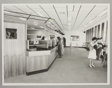 Ringwood and District Historical Society
Photograph, Interior of Ringwood North State Bank , south-east corner of Dickson's Crescent and Warrandyte Road
The new Ringwood North State Bank premises on the south-east corner of Dickson's Crescent. Showing customer service area. Opened 23 August 1982At the corner of Dickson's Cresent and Warrandyte Road, Ringwood North. Photographer - Les Gorrie Photography, 28 Waldemar Road, Heidelberg. Negative #82334 -
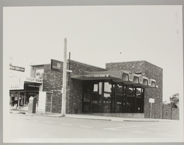 Ringwood and District Historical Society
Photograph, Ringwood North State Bank , north-east corner of Dickson's Crescent and Warrandyte Road
The new Ringwood North State Bank premises, November 1979 on the north-east corner of Dickson's Crescent. Exterior view.At the corner of Dickson's Crescent and Warrandyte Road, Ringwood North. Photographer - Les Gorrie Photography, 28 Waldemar Road, Heidelberg. Negative #2389 -
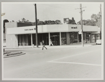 Ringwood and District Historical Society
Photograph, Ringwood North State Bank , south-east corner of Dickson's Crescent and Warrandyte Road
Photo of the new Ringwood North State Bank premises, opened 23 January 1983At the corner of Dickson's Crescent and Warrandyte Road, Ringwood North. Photographer - Les Gorrie Photography, 28 Waldemar Road, Heidelberg. Negative #82335 -
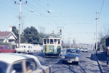
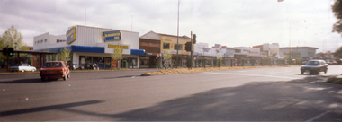 Whitehorse Historical Society Inc.
Photograph, Mitcham Shopping Centre, 1/11/2000 12:00:00 AM
Coloured Photograph of Mitcham Shopping Centre - north side of Whitehorse Road between Britannia Mall to Mitcham Road. Photograph taken from southern side of Whitehorse Road near the Post Office opposite Britannia Mall.mitcham shopping centre, whitehorse road mitcham, britannia mall, mitcham, mitcham road -
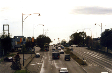 Whitehorse Historical Society Inc.
Photograph, Whitehorse Road, Mitcham
Coloured photograph of Whitehorse Road, Mitcham. Lights are at the junction of Whitehorse and Mitcham Roads and traffic on left is heading east towards Ringwood. Church on the left is the Mitcham Anglican Church, which is on the corner of Whitehorse Road and Edwards Street.whitehorse road, mitcham -
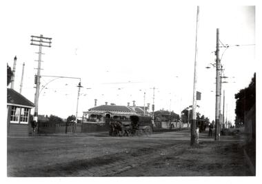 Melbourne Tram Museum
Photograph - Black & White Photograph/s, c1919
Black and White Photograph of a view of the intersection of Burke and Whitehorse Roads with a tram at the terminus in Burke Road. In the view is a horse drawn vehicle turning into Whitehorse Road, a shelter, tram overhead, street lighting and grand house on the corner.On rear in ink, "At Burke & Whitehorse Rds 1919c"trams, tramways, whitehorse rd, burke rd, pmtt, shelters -
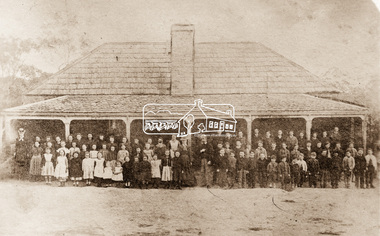 Eltham District Historical Society Inc
Photograph, Yeoman and Co, Eltham State School No. 209, Dalton Street, Eltham, 1864
Copy by Yeoman and Co. of original c.1864 photograph. The first Eltham State School building with school group. David Clarke (Head Teacher) and his sister, Catherine are standing in the centre of the group. Built with stone walls and wooden shingles on the roof. This was the first State School building which was built in 1856 and replaced with a new building in 1875 after the stone walls collapsed outwards. Published in Nillumbik Maii; Edition 20, 13 Sep Harry Gilham notes: - Believed to be the National School at Eltham on the Dalton Street site 1857-1874 - £220 cost; £110 National Board and £110 local patrons - 40' (38'6") x 16' x 10' walls - David Clark Head Teacher and Catherine Clark, Sewing Mistress - Its building materials came from the western edge of the site where sandstone removed is still evident and children are protected from the site by the fences of 1994 of wire mesh and palings beside the residence - School had 7' verandah added in 1861 - Clarks used half the building as a residence from 1857-1866 when enrollments required use of the whole building - The Clarks moved to then Shoestring residence in Metery Road adjacent to the end of the school ovalSepia photograph copy of original (c.1864) photograph mounted on cardYeoman and Co. Sydney Road Brunswick Nillumbik Mail publication details; Edition 20, 13 Sepcatherine clarke, class photo, dalton street, david george clark, eltham, eltham state school no. 209, school group, national school -
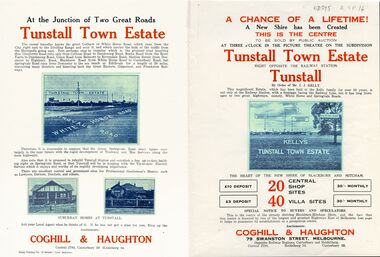 Whitehorse Historical Society Inc.
Legal record - Document, Tunstall Town Estate
Land subdivision at Tunstall 1926 bounded by Springvale Road, Whitehorse Road, Railway Parade.Land subdivision at Tunstall 1926 bounded by Springvale Road, Whitehorse Road, Railway Parade. Original in Haughton Maps LaTrobe LibraryLand subdivision at Tunstall 1926 bounded by Springvale Road, Whitehorse Road, Railway Parade. land subdivision, springvale road, nunawading, railway parade, kelly, j, nunawading state school, no. 4190, shire of blackburn and mitcham, whitehorse road, silver grove, glendale street