Showing 8492 items
matching snowy-river-dry-cleaners
-
 Bendigo Historical Society Inc.
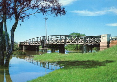
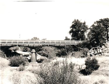
Photograph - PHOTOGRAPH. ELMORE, 1993
Photograph. Bridge over the Campaspe River at Elmore. -
 Hand Tool Preservation Association of Australia Inc
Page
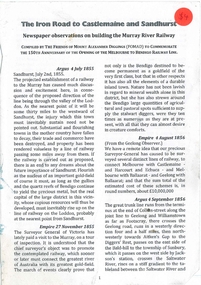
This item is part of the Thomas Caine Tool Collection, owned by The National Trust of Australia (Victoria) and curated by the Hand Tools Preservation Association of Australia.Page, sydney harbour + brisbane river bridge -
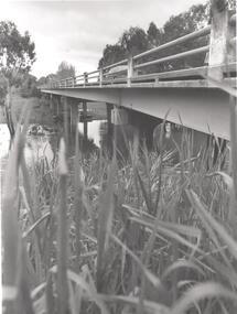
 Maldon Vintage Machinery Museum Inc
Book, The Friends of Mount Alexander Diggings, The Iron Road to Castlemaine and Sandhurst
Newspaper observations on building the Murray River RailwayCompiled by the Friends of Mount Alexander Diggings (FOMAD) to Commemorate the 150th Anniversary of the Opening of the Melbourne to Bendigo Railway Line -
![Painting - Oil on paper, [Landscape] by Jeff Woodger, 2006](/media/collectors/530576742162ef0fa09a2288/items/534748179821f420f8c038e4/item-media/57d8eb59d0cdd109ac738cfd/item-fit-380x285.jpg) Federation University Art Collection
Federation University Art CollectionPainting - Oil on paper, [Landscape] by Jeff Woodger, 2006
Jeff WOODGER Born Bendigo, Victoria Jeff studied art at La Trobe University in 1986, and a Graduate Diploma in teaching in 1989. He worked as a teacher from 1990 to 1998. In 1994 Jeff was awarded a Master of Arts from La Trobe University. He then studied at the prestigious Slade School, London and the National Gallery of Art in Washington D.C. Jeff Woodger completed a Doctor of Philosophy (Fine Art) at University of Ballarat (now Federation University) in 2006. This work was part of the exhibition assessment for this study. Jeff Woodger has lived and worked in Japan regularly since 1994. His passion is to paint post romantic landscapes in the classical style which are deeply inspired by many of the seventeenth century greats such as Claude Lorraine and Salvator Rosa. This item is part of the Federation University Art Collection. The Art Collection features over 2000 works and was listed as a 'Ballarat Treasure' in 2007. This item is part of the Federation University Art Collection. The Art Collection features over 2000 works and was listed as a 'Ballarat Treasure' in 2007.Framed oil on paper landscape with river in the foreground.art, artwork, jeff woodger, alumni, landscape, available -
 Port Fairy Historical Society Museum and Archives
Photograph
Black and white panoramic photograph of the Moyne rivership, boat, sea, river, ss casino -
University of Melbourne, Burnley Campus Archives
Photograph, James Leslie Provan, Burnley 1942 Album Page 2, 1942-1943
View of Yarra River from Yarra Boulevard.yarra river, yarra boulevard, burnley, 1942, j.l. provan -
 Lakes Entrance Historical Society
Photograph - Bridges, Murray Views Gympie, 1980
Photo printed on Jumbo card by Murray Views, Gympie QLDColour photograph showing swing bridge on Latrobe River, shows north facing side of bridge, willows on opposite bank on site of Latrobe River wharf, river running very high, two red gum trees in water on left. Longford Victoriabridges, waterways -
 Orbost & District Historical Society
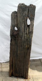
timber post, 1880's
This was retrieved in 1982 by Geoff Stevenson. It was a part of the original jetty at Tabbara on the Brodribb River used by Samuel Richardson who established his mill in .1882. The first saw mill plant at Orbost was set up early in 1876, There was a constant demand for timber to supply the growing townships of Orbost , Marlo and surrounds. It was at this mill that the original paddle steamer Curlip was built. More information in "Curlip" by May Leatch.The Richardson family was one of the very early settler families to establish themselves in the Orbost district. Before the Richardson's mill was established, settlers in the Snowy region either rough cut their own timber or had to bring it in from mills some distance away.A portion of a post from the old Tabbara jetty on the Brodribb River - Samuel Richardson's mill . There is still some original preserving tar on it. It has two holes, one with a bolt attached. It is possibly made from mahogany cut on the site.richardson-samuel tabbara-jetty brodribb-river -
Phillip Island and District Historical Society Inc.
Photograph, 1983
This photograph was taken by the Herald & Weekly Times and donated to Audrey McFee. Chicory was first grown on Phillip Island in 1870. It was used in coffee essence and for medicinal purposes.Dried and roasted chicory chips ready to be sent away for grinding preparatory to being mixed with coffee and sold in liquid or powdered form.local history, photography, photographs, slides, film, chicory industry, black & white photograph, audrey mcfee, chicory, phillip island -
 Bendigo Historical Society Inc.
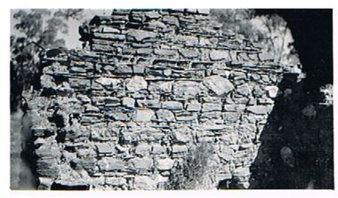
Photograph - RICHARDSON'S HUT - STONE BUILDING
Photo: dry stone wall, - end of house ( ? ), described as 'Richardson's hut' Written on back of photo' ' Chick (?) Richardsons Hut Remains 'house, public, richardson, stone wall, hut, richardson's hut. -
 Coburg Historical Society
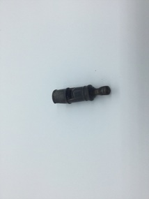
Photograph - Horse tram driver's whistle, C. 1890
The whistle was used by the horse tram driver.dark brown wooden whistle, dried pea inside, mouth piece cork?, whole for a string, sign of usage on mouth piecetram, public transport, tramways -
 Hume City Civic Collection
Photograph, 1960s
The two-arched bluestone bridge which spans the Jacksons Creek at the east end of Sunbury township, was built in 1857 and continued to be used as a road bridge on the main Sunbury Road-Macedon Street until the early 1970s when a wider bridge replaced the original bluestone bridge.A black and white photograph of a two- arched bluestone bridge which spans a dry creek bed. A bulldozer is on the riverbank on the RHS of the photograph.bridges, bluestone bridges, jacksons creek, harris, thomas lascelles, macedon street, george evans collection -
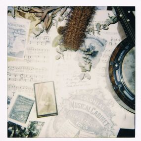 Bendigo Historical Society Inc.
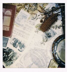
Photograph - PETER ELLIS COLLECTION: MUSIC SHEET
Colour polaroid photograph. Sheet music. Banjo. Colonial Musical Cabinet containing new and popular songs. Native dried flower.entertainment, music, sheet music -
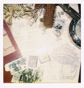 Bendigo Historical Society Inc.
Photograph - PETER ELLIS COLLECTION: MUSIC SHEET
Colour polaroid photograph. Sheet music. Banjo. Colonial Musical Cabinet containing new and popular songs. Native dried flower.entertainment, music, sheet music -
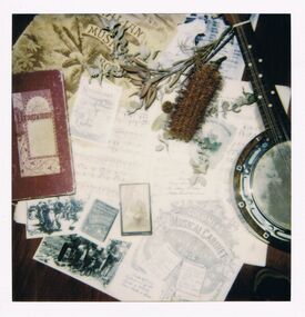 Bendigo Historical Society Inc.
Photograph - PETER ELLIS COLLECTION: MUSIC SHEET
Colour polaroid photograph. Sheet music. Banjo. Colonial Musical Cabinet containing new and popular songs. Native dried flower.entertainment, music, sheet music -
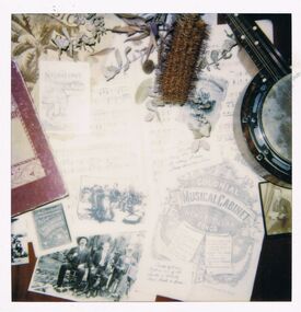 Bendigo Historical Society Inc.
Photograph - PETER ELLIS COLLECTION: MUSIC SHEET
Colour polaroid photograph. Sheet music. Banjo. Colonial Musical Cabinet containing new and popular songs. Native dried flower.entertainment, music, sheet music -
 Bendigo Historical Society Inc.
Photograph - PETER ELLIS COLLECTION: MUSIC SHEET
Colour polaroid photograph. Sheet music. Banjo. Colonial Musical Cabinet containing new and popular songs. Native dried flower.entertainment, music, sheet music -
 Greensborough Historical Society
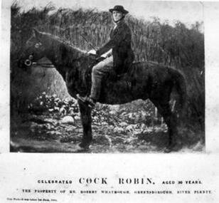
Photograph - Digital image, Whatmough's "Cock Robin", 09/01/1850
Photograph of the horse "Cock Robin" owned by Robert Whatmough. Mr Robert Whatmough operated an orchard and commercial nursery on the property 'Willis Vale' at Greensborough and was related to Charles Partington by marriage. [Reference: The Argus - Wednesday 9 January 1850 Page 4... The River Plenty Races. – These races came off yesterday. The Plough Inn Cup of £25 was won by Mr. Beale’s Wallaby, beating three others. A pony race was won by Mr. Whatmough’s Cock Robin. A purse of £10 was won by Mr. Haye’s Gazelle.] The Whatmough family were Greensborough pioneersDigital copy of colour photograph.Photograph has printed caption: Celebrated Cock Robin aged 30 years. The property of Mr Robert Whatmough, Greensborough River Plenty. Date is illegible.cock robin, robert whatmough -
 Orbost & District Historical Society
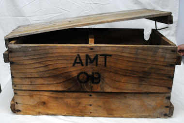
box, first half 20th century
This box was used by Lindsay Thomson's mother, Annie M. Thomson for the transport of hen eggs from Orbost to Melbourne by rail - C 1940's -1950's. The Bairnsdale-Orbost railway was opened in 1916 to serve the agricultural and timber industry. Because of the decline in traffic and heavy operating costs, the line was finally closed in August, 1987. Orbost Railway Station was opened on Monday 10 April 1916 as the terminus of the Orbost railway line, and closed in 1987. The station was located on the west side of the Snowy River despite the town of Orbost being on the east side of the river, in order to save on the costs of a bridge over the river, which at the time had highly variable levels. This item is associated with the history of the Orbost-Bairnsdale railway line and therefore reflects the role that the rail line played in the social and economic history of Orbost. A wooden box with two inside sections and a wooden lid which is secured on both ends by large nails/spikes which are fitted into a groove and are then turned. On front and back in black stencilled letters A M T O B container railway eggs -
 Ballarat Tramway Museum
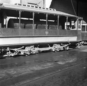
Photograph - B&W print of donated negative, John Webster, 21/08/1955 12:00:00 AM
Yields information about the appearance of the Geelong Scrubber Tram, 1955 and its truckBlack and white digital print from scan of a donated negative showing a side on view of Geelong Scrubber or track cleaner, and in particular the truck. Photo by John Webster, 21-8-55. Track cleaner. Reference Reg Item 4196 for another view of the tram in the same location. Photo assumed to be taken on the same date. Black and White prints made from scan of negative. Original Negative stored with Negatives. Negative scanned at hi res 2/6/2020 and image updated.On left hand side of the negatives in ink is "EI 4"tramways, trams, geelong, tramcars, scrubber tram, tram scrubber -
 Wodonga & District Historical Society Inc
Album - Hume Reservoir Australia Album - The River Murray at the site of the dam 28th November, 1919
This set of photos is from a leather bound album bearing the inscription "HUME RESERVOIR AUSTRALIA" plus 'The Rt. Hon. L. C. M. S. Amery, P. C., M .P.' all inscribed in gold. It was presented to The Rt. Hon. L. C. M. S. Amery, P. C., M. P, Secretary of State for Dominion Affairs on the occasion of his visit to the Hume Reservoir on 2nd November 1927. This album is of local and national significance as it documents the planning and development of the Hume Reservoir up to 1927. It was the largest water reservoir in the British Empire. The album records the pioneering engineering work that went into its construction.DEPARTMENT OF PUBLIC WORKS, N.S.W. RIVER MURRAY WATERS SCHEME. HUME RESERVOIR. The River Murray at the site of the dam on 28th November 1919 looking upstream. hume reservoir australia, river murray waters scheme, hume weir diagrams, hume plan details -
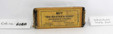 Coal Creek Community Park & Museum
Record Cleaner
Record cleaner, consisting of a wooden top with carpet like fabric for cleaning records; the label states "Buy 'His Master's Voice', Instruments and Records, 'The quality line". Trademarked "Gramophone" & "His Master's Voice". -
City of Kingston
Photograph - Colour, 31 January 1993
Patterson Lakes is a suburb in the City of Kingston that is built one kilometre upstream of the mouth of the Patterson River. The area is bordered by the Patterson River and Eel Race Drain which enters the Kananook Creek. The suburb consists predominantly of newer housing developments and the tidal canal system of the development joins Port Phillip Bay. Patterson Lakes and the Kananook Creek were previously part of the extensive Carrum Carrum Swamp. The area was once a source of fish and eels for the Mayone-Bulluk clan of the Bunurong people. Over time the area was drained and in 1973 investigations commenced into the development of a unique residential area that would be built adjacent to canals and waterways. It was originally proposed to be known as "Gladesville". The development would give the suburb's homeowners access to Port Phillip Bay "from their back door". Circa 1974, the area was rezoned from rural to residential and named Patterson Lakes. Development has been continuous since the 1970s with construction of residential housing, schools, shopping centres, marinas, a hotel and library.Laminated colour aerial photograph of the Carrum and Patterson Lakes region within City of Kingston. This 1993 image includes Patterson River Secondary College, Roy Dore Reserve, Kananook Creek and Nepean Highway. The railway line can be seen as it veers inland from Eel Race Road, Seaford. The section of Ocean Reef Drive and Palm Beach Drive in Patterson Lakes appears to be a recent development with many spare blocks and new houses under construction.Black typed lettering on white adhesive label: 31.1.93 Black typed lettering on white adhesive label: 27E/7140 31/1/93 12.55 pm Black typed lettering on white label: 7140 Yellow round adhesive label located on left sidepatterson lakes, seaford, kananook creek, carrum carrum swamp, canals and waterways -
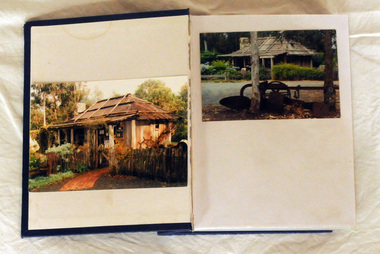 Orbost & District Historical Society
album, Orbost Visitor Information Centre, 1997
The original slab hut was built in 1872 as a family dwelling on a site about 3 km upstream from the junction of the Buchan and Snowy Rivers about 40 kms from Orbost on the Yalmy Rd. No nails were used in the construction; it was all wired together. After a period in storage the Slab Ht was opened in its present location in Orbost as the Information Centre in 1987. This album documents an important event in Orbost.A photo album with a navy blue cardboard cover with gold embossing on the front and spine. It contains 32 photos of the 1997 10 year anniversary celebration of the establishment of the Slab Hut - the Orbost Visitor Information Centre. It also contains 3 postcards and 2 fridge magnets.slab-hut album orbost -
 Orbost & District Historical Society
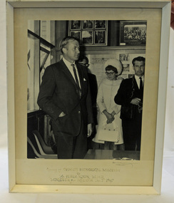
framed black and white photograph, December 1 1967
This photograph shows Peter Nixon, Minister For The Interior officially opening the Orbost Historical Society Museum on December 1st, 1967. The first Orbost Museum was opened in 1967. It was situated in Nicholson Street, Orbost. Peter Nixon grew up on the family farm on the Snowy River. He entered Federal Parliament in 1961 as the Member for Gippsland, holding various portfolios before retiring in 1983.Peter Nixon grew up on the family farm on the Snowy River. He entered Federal Parliament in 1961 as the Member for Gippsland, holding various portfolios before retiring in 1983. The Nixon family has been in the Orbost district since 1885.A large black / white photograph of a man in a suit with one hand in his pocket Standing behind him are two men and a woman. The photograph has been taken inside the museum. The photograph is mounted on a white buff card and is in a white wooden frame. on front below the photograph - " Opening of the Orbost Historical Society Museum by Mr Peter Nixon M.H.R., Minister of the Interior 1st December 1967"museum-orbost-opening nixon-peter -
 Ballarat Heritage Services
Photograph - Photograph - Colour, Lisa Gervasoni, Remains of Angus McMillan's Bushy Park Home, 2014, 07/06/2014
Angus McMillan was born in 1810 at Glenbrittle in the Isle of Skye. He was one of fourteens sons of Ewan McMillan. Angus McMillan arried i New South Wales in January 1839, and became an overseer for Captai nLachlan Macalister. I n 1839 Angus McMillan travelled south. He settled for a time on Jame MacFarlane's statin at Currawong. IOn 28 May 1839 Angus MacMillan stated travelling southward toward the coast. Angus Macmillan named the Avon River after the river of the same name in his native Scotland. In 1840 he established a pastoral run at Bushy Park, near Maffra. William Odell Raymond established a run in the area in 1842, and built his house, Strathfieldsaye, during 1848–54. European settlement did not take place without resistance, and in return, massacres were inflicted by Angus McMillan and others on Gunai people, especially between the years of 1840 and 1850. (wikipedia) The first application for the 'Bushy Park' run appears in the “Port Phillip Gazette” on 13 August 1843. It was taken up by Angus McMillan, who also took up the 'Boisdale' run for his employer Lachlan Macalister at the same time. In March 1844 a Licence to occupy the 16,000 acre 'Bushy Park' was granted to McMillan. In the late 1840s Andrew Martin and Matt McCraw built Angus McMillan's Bushy Park homestead. Aboriginal killings in Gippsland area most often were never formally recorded, but lived on in folklore, mainly in place names pinpointing what some historians now refer to as "massacres", and others as "conflicts". There is Boney Point, on Lake Wellington, Butchers Creek, near Metung, Slaughterhouse Gully, at Buchan, Skull Creek, at Lindenow, and, notoriously, Warrigal Creek, at Woodside. "Here, according to a couple of contemporary - though not eyewitness - reports, between 50 and 150 blacks were killed in an orgy of revenge after the murder and mutilation of a leading Scots settler, Ronald Macalister. If anybody had any doubts about the fitness of commemorating McMillan's name, no one voiced them then. Gippsland was, and still is, dotted with stone cairns tracing his route from Omeo, down the Tambo Valley to the fertile plains where he was to make (and lose) his fortune. And where, according to a growing body of opinion, he was to lead the "Highland Brigade", a band of armed settlers, against the Kurnai. History is fiction agreed on, and it is written by the winners. For most of the past 150 years, McMillan has been hailed as a trail-blazing pioneer. The legend began to crumble 20 years ago with publication of new histories, which at first outraged Gippsland historical societies and old residents, but which have gradually changed the way McMillan is viewed. ... Still, not all McMillan's contemporaries agreed with the "Highland Brigade" and its methods. Henry Meyrick, an English-born squatter, wrote to relatives in disgust about his neighbours. He estimated that 450 had been killed, and wrote: "Men, women and children are shot down whenever they can be met with. Some excuse might be found for shooting the men by those who are daily getting their cattle speared, but what they can urge in their excuse who shoot the women and children I cannot conceive." (http://www.theage.com.au/articles/2002/04/26/1019441303552.html, accessed 20 September 2016.) The Gippsland electorate is called 'McMillan' in his honour. Photographs of the remains of a timber home used by squatter Angus McMillan at his "Bushy Park" property on the Avon River. angus mcmillan, bushy park, avon river, squater -
 Kew Historical Society Inc
Photograph - View of the Yarra River from 8 Kellett Grove, North Kew, 1948
North Kew, now divided between Kew and Kew East, bordered the Yarra River. As such, it was a region subject to flooding in the Yarra Valley. Development beyond this point (ie Kellett Grove) was limited by the City of Kew's planning regulations. Prior to urban development, the area since European settlement and the first land sales in the district in the 1840s, had been used for dairy farming. The view from the rear of 8 Kellett Grove predates the construction of the Eastern Freeway so provides a rare view of the area before it was built.Small sepia snapshot taken from the back yard of a house at 8 Kellett Grove, in what was then known as North Kew. A tower of the Kew Asylum on the top left of the horizon assist the viewer to recognise that the land to the left of the river is in Kew and Studley Park.Verso: NORTH KEW 1948 / Stamped 51019yarra river -- north kew, kellett grove -- north kew -
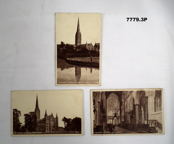 Bendigo Military Museum
Postcard - POSTCARD - SALISBURY, UK, J Welch and Sons, c. WW1
Postcards sent by R.H. Baron to his mother, sisters and Elsie. Part of the "Robert H. Baron" No 3596 and Cooper Collections. See Catalogue No. 1981P for details of Baron's service.1. Sepia toned photograph of the exterior of a gothic style cathedral with spire and two lantern towers. 2. Sepia toned photograph of a cathedral with spire from a river location. 3. Sepia toned photograph of the nave and choir of a gothic style cathedral.1. Salisbury Cathedral, West front. Handwritten in pencil on back: 'Letter to R.H. Baron's sisters' - no date. 2. Salisbury Cathedral from the River. Handwritten in pencil and black ink: ' Letter to R. H. Baron's mother. Ink section indecipherable. - no date. 3. Salisbury Cathedral, choir and nave. Handwritten in black ink: 'Dear Elsie etc'.robert h. baron, cooper collection, postcards, salisbury uk, ww1 -
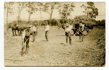 Orbost & District Historical Society
black and white photograph, first half 20th century
The men in this photograph are harvesting dry bean plants. They have been threshed with flails and raked. the dry straw is tossed off and the dry beans are collected to be hand sorted.This item is associated with the seed bean industry which was a major industry in the Orbost district for the first half of the 20th century.A black / white photograph / postcard of five men raking hay in a paddock with two horses and carts in the background.on back - "Orbost, M. Gilbert"agriculture-beans orbost-bean-seeds -
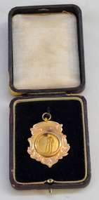 Orbost & District Historical Society
medal, 1928
This medal was presented to J.G.Ralston by the Orbost Cricket Club in 1929 for Fielding. John Gavin Ralston was born 26 July 1914 at Eden, N.S.W. and came to Orbost in the early 1920's, with his parents and siblings. They lived at the corner of Tennyson and Salisbury Streets. Jack was educated at Orbost Higher Elementary School before being apprenticed to William Ross at the Snowy River Mail as a lino-type operator. He married Jean Cameron. After WW11 when he served overseas in the islands) He resumed his trade at the Snowy River Mail until 1949 when began J.G.& J.M. Ralston, Seed & Produce Merchants. Jack Ralston was very involved in the Orbost sporting community, the Presbyterian Church and the Orbost Municipal Band. He also served in the Orbost sub-branch of the R.S.L. He died on April 15 1967. (ref. Margaret Smith O.D.H.S. Newsletter)John Ralston was a prominent Orbost citizen.A 9 ct gold shield-shaped medal with a small hanging hoop. In the centre is an embossed picture of a batsman at the wicket. This is inside a circle. The bottom edge is decorated with leaves. The medal is inside a thin leather look wooden box which is hinged and has a push button metal latch. The box is brown and the inside lid is padded.on back - OCC At bottom - 9 ct Presented to J.G. Ralston Fielding Trophy 1928-1929cricket-orbost sport ralston-john-gavin medal