Showing 2471 items matching " township"
-
 Flagstaff Hill Maritime Museum and Village
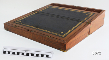
Domestic object - Writing Slope, early 20th century
In the words of the donor, Betty Stone, "This fitted writing slope box belonged to Ellis Dale of “Latrigg”, Wangoom, Warrnambool, and has an inscription “E. Dale”, hand written by Ellis on a small brass plaque featured on the lid. Ellis Dale, born 21 November 1860, was the second son of William and Elizabeth Dale, of Dale Bluestone Quarries Wangoom. He worked with his father at the quarries, and continued, after his father's death, to operate the family business with his son lvor until he died, aged 79 years, on 2 August 1940. Although the tradition was that the writing box was originally owned by Ellis's father, William Dale, there is some doubt that he brought it with him from England when he migrated in 1852 - however, we do know that it is at least one hundred years old. (Note: For additional information please refer to my book “Pioneers and Places - A History of three Warrnambool Pioneering Families” ie. Chamberlain, Dale and Lees Families)This item is associated with the Warrnambool pioneer families of Chamberlain, Dale and Lees. These families are listed in the Pioneers' Register for Warrnambool Township and Shire, 1835-1900, published by A.I.G.S. Warrnambool Branch. The item is significant for its association with a ‘glory box’ or hope chest’, a tradition of single ladies making and collecting a range of linen and other domestic items in preparation for their future marriage.Polished wooden Writing Slope or Travellers Desk. Owned by Ellis Dale. Box opens to be a sloped writing desk, with a leather writing surface decorated with a gold leaf border, and several compartments; one has a slightly concaved cover that pivots to open. Leather-covered boards hinge at the centre, and both sides lift, revealing further storage. Brass protectors on top corners, inlaid brass strengthening supports on two corners. Brass slide-releasing catches secure writing base as desk closes. The brass shield centre of the lid is engraved. Part of the 'Chamberlain Dale Lees Collection.Engraved shield on lid "E.Dale / Wangoom"flagstaff hill, warrnambool, shipwrecked coast, flagstaff hill maritime museum, maritime museum, shipwreck coast, flagstaff hill maritime village, great ocean road, chamberlain, dale, lees, stone, betty stone, warrnambool pioneers, writing slope, writing box, traveller's desk, portable desk, lap desk, ellis dale -
 Flagstaff Hill Maritime Museum and Village
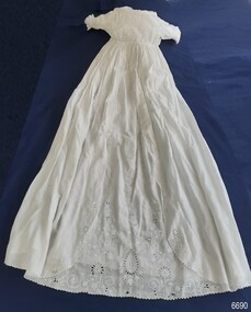
Clothing - Christening Gown, Sarah Lees, c. 1860's
In the words of the donor, Betty Stone, "This gown was originally made by my great grandmother Sarah Ellis (nee Chamberlain) Lees of Wangoom, Warrnambool. Later, the gown was altered by her daughter Ann (nee Lees) Dale who also used it for the christenings of her five children in the 1890's, and later still, for some of her grandchildren. Sarah Ellis Chamberlain, born in Thriplow, Cambridgeshire, England on 31 July 1844, sixth child of Joshua and Susan Chamberlain, was ten years old when she arrived in Australia with her parents and siblings in January 1855. Ten years later, in 1864, Sarah Chamberlain married Lees Lees, a skilled stonemason who had migrated from Saddleworth, Yorkshire. Lees Lees purchased land in McGregors Road, Wangoom, Warrnambool where he operated a successful stonemasonry, contracting business until his death in 1912. The Lees farm, which eventually consisted of about fifty acres, was situated adjacent to both the Chamberlain and Dale farms. Sarah Lees was a meticulous homemaker who also fashioned and sewed clothes for her seven children. A photograph of the eldest child, Anne, taken in 1868, depicts her wearing a dress and pantaloons sewn by her mother. Sarah also crocheted lace curtains for her home in addition to large tablecloths and other articles. According to family legend, the skirt of this christening gown was part of the original gown hand-sewn by Sarah (nee Chamberlain) Lees which was used for the christening of her children. The gown was later passed on to her daughter Anne (nee Lees) Dale who, also an expert needlewoman, replaced the bodice and used it for the christening of her five children born between the years 1890 and 1899. Still, later, at least two children of the third generation (Sarah Lees' great-grandchildren) also wore this gown when christened at Christ Church Warrnambool. Sarah (nee Chamberlain) Lees died in 1932, aged 87 years, at her daughter Anne Dale's home in Latrigg. Anne (nee Lees) Dale died in 1948 aged 83 years, at her home in Latrigg." (Note: For additional information please refer to Betty Stone’s book “Pioneers and Places - A History of three Warrnambool Pioneering Families” ie. Chamberlain, Dale and Lees Families)This item is associated with the families of Chamberlain, Dale and Lees. These families are listed in the "Pioneers' Register" for Warrnambool Township and Shire, 1835-1900, published by A.I.G.S. Warrnambool Branch. The item is a fine example of late-19th-century needlework and handmade domestic items.Christening gown made by Sarah Ellis. White with unusual Broderie Anglaise yoke. The long-sleeved garment has a gathered waist and a long skirt. The front centre of the skirt has a floral Broderie Anglaise and cut work panel insert.Circa 1860's. From the 'Chamberlain Dale Lees Collection’, donated by Betty Stoneflagstaff hill, warrnambool, shipwrecked coast, flagstaff hill maritime museum, maritime museum, shipwreck coast, flagstaff hill maritime village, great ocean road, chamberlain, dale, lees, stone, betty stone, warrnambool pioneers, sarah ellis, hand sewn, christening gown, baby wear, clothing, 19th century -
 Federation University Historical Collection
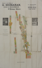
Plan, G. Buchanan's Plan of the Berringa Gold Mines, 1866?
This plan is associated with former Ballarat School of Mines student Richard Squire (1875-1876) Gift of the Squire FamilyColoured plan of the Berringa Goldmines.squire, richard squire, berringa, g. buchanan, buchanan, stockbroker, birthday freehold, f. holst, holst, staffordshire reef, williams fancy, kangaroo, moonlight, cgt, staffordshire reef township, w. prie, northern birthday, a clinton, birthday star, a. lamb -
 Federation University Historical Collection
Book, Historic Sites Survey: North Central Study Area, 1979, 1979
The North Central Study Area included the Shires of Avoca, Bet Bet, east Loddon, Goulburn, Untly, Kara Kara, Korong, Maldon, Marong, Metcalfe, McIvor, Newstead, Strathfieldsaye, Stawell, Talbot, Clunes, Tullaroop and Waranga. 153 page book with white plastic binding. It is an historic sites survey for the North Central Study Area commissioned by the Land Conservation Council, the Ministry for COnservation and the Australian Heritage Commission. castlemaine, mount alexander goldfield, maldon, percydale, warrenmang, moliagul, tarnagulla, stuart mill, the whipstick, whroo, rushworth, graytown ironbark forest, st arnoaud, new bendigo, landsborough, inglewood, kurting, wedderburn, wehla, kooroora, langham flat, mcintyre, rheola, diamond hill, fosterville, coliban water works, green gully, newstead, muckleford forest, costerfield, graytown, bailieston, waranga irrigaiton system, eucalyptus distillery, mia mia bridge, korokubeal township researce, concegella slate quarry, chewton, fryerstown, kingower, timor, talbot, majorca, carisbroook, clunes, st arnaud, taradale, icomos, dunolly, limestone, castlemaine slate quarry, harcourt granite, taradale railway viaduct, loddon united waterworks trust, gouldburn weir, carisbrook lock-up, history of tree planting in streets, history of public reserves, r.u. nicholls nurseryman, thomas lang, francis moss, ballarat botanical gardens, ballarat school of mines botanical gardens, lake wendouree, victoria park, ballarat, muont holled smith, ballaarat old cemetery planting, eastern oval, ballarat east botanical gardens, ballarat east town hall gardens, eureka stockade reserve, ballarat observatory plantings, yarrowee creek plantings, yarrowee bluestone channels, ballarat woollen mill, band and albion mullock heap, black hill plantings, yarrowee creek channels, canadian creek channel, specimen vale channel, poverty point reserve, union jack reserve buninyong, imperial mine, buninyong, victoria street plantings, bridge mall, sturt street gardens, ballarat avenue of honour plantings, white flat oval plantings, camp street, elms, burnt creek -
 Federation University Historical Collection
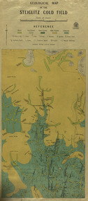
Map, Geological Map of The Stieglitz Gold Field, 1940
At the bottom of the 2nd page, there is text that reads "Geologically and topographically surveyed in 1909 by W.H. Ferguson, Assistant Field Geologist. Published 1940."Rectangular geological map edged in masking tape showing Steiglitz, Victoria. Scale 48 chains to 4 inches.steiglitz, geology, geological map, north albion, moreep, mining, mine, caribald reef, durdidwarrah, gilbraltar hill, mount pleasant gully, township of steiglitz, w.h. ferguson, garibaldi reef, yankee gully, kinglock mine engine shaft, herbert werner frederick de nully, albion gully, virago reef, mulrooney's reef -
 Ringwood and District Historical Society
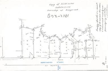
Document - Copy of Lands Department Field Notes - Subdivision Township of Ringwood, Victoria, Field Notes 1902/269 - Part of O.P. R72D surveyed in 1902
Foolscap size photocopy of survey map with handwritten notations. References include Maroondah Highway, (opposite) Mines Road, Ti tree, Sandy soil, heath, spear grass, box & stringy bark sapplings, gentle slope to creek, E. Drury. I certify that this is a correct copy of the recorded observations and measurements made by me personally and my assistant (signed) W. Thorn. -
 Ringwood and District Historical Society
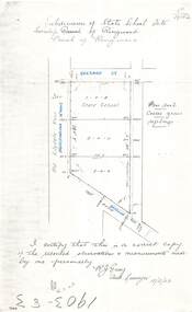
Document - Copy of Lands Department Field Notes - Subdivision of State School Site, Township of Ringwood, Victoria, Field Notes 1903/83 - Part of O.P. R72C Surveyed 13/2/1903
Foolscap size photocopy of survey map with handwritten notations. References include Everard Street, Old Lilydale Road (Maroondah Highway), Dublin Road, poor soil, coarse grass, saplings, I certify that this is a correct copy of the recorded observations & measurements made by me personally (signed) R.J. Gray Autorised Surveyor 13/2/03. -
 Ringwood and District Historical Society
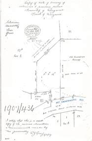
Document - Copy of Lands Department Field Notes - Survey of Extension to Recreation Reserve, Township of Ringwood, Victoria, Field Notes 1907/436 - Part of O.P. R72D Surveyed 6.8.1907
Foolscap size photocopy of survey map with handwritten notations. References include New Lilydale Road 3 chains wide (Mount Dandenong Road), Silurian, undulating, poor grass, Corner cut off to allow for road in future subdivision, Old recreation reserve, (circled area) oval now in use, A. Gisler, I certify that this is a correct copy of the recorded observations & measurements made by me personally (signed) R.J. Gray 6/8/07. -
 Ringwood and District Historical Society
Document - Copy of Lands Department Field Notes - Subdivision Sec E, Township of Ringwood, Victoria, Field Notes 1908/670 - Survey O.P. R72E dated November 1908
Foolscap size photocopies of survey maps with handwritten notations. -
 Ringwood and District Historical Society
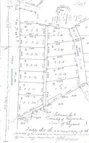
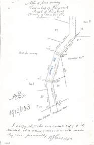
Document - Copy of Lands Department Field Notes - Township of Ringwood, Victoria, Field Notes 1913/163 - Part of O.P. R72D surveyed April 1913
5612b Foolscap size photocopy of survey map with handwritten notations. References include Mines Road, New Lilydale Road (Maroondah Highway), (area) Held for mining, Recreation Reserve, Sec D, Sec E, I certify that this is a correct copy of the recorded observations & measurements made by me personally (signed) R.J. Gray 2/4/13. -
 City of Moorabbin Historical Society (Operating the Box Cottage Museum)
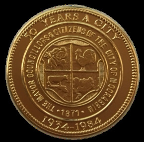
Badge - City of Moorabbin - 50 Years Medal, 1984-85
A gold-plated medal issued by the City of Moorabbin to commemorate the quincentenary of Victoria in 1984-5. It features the City Shield incorporating vegetables, a rooster, a cow and a house, and the sesquicentenary logo. The township of Moorabbin, known as South Brighton until 1909, remained small, with the Plough and Harrow Hotel as its main building. In 1917 Sandringham borough was formed by severance from Moorabbin shire and in 1920 Mentone and Mordialloc were also severed. In the remaining Moorabbin shire the Moorabbin township was still small (1,770 persons), but the shire grew in population during the 1930s. On 10 October 1934 it was proclaimed a city. It existed as a separate municipality until 1995. When local government boundaries were changed in 1994 about half of Moorabbin city was united with Glen Eira city and about half with Kingston city. On 15 December, 1994 the City of Chelsea, parts of the Cities of Mordialloc, Moorabbin, Springvale and Oakleigh were amalgamated to create the City of Kingston by Order of the Governor in Council. On the same day Glen Eira City Council was formed from the City of Caulfield and the remaining part of the City of Moorabbin.Gold Plated Medal Side one: Within a wide rim formed by a line circle, the City Shield incorporating vegetables, a rooster, a cow and a house; around, THE MAYOR COUNCILLORS & CITIZENS OF THE CITY OF MOORABBIN; around on broad rim, 50 YEARS A CITY 1934 - 1984. Side 2: Logo of the Victorian sesquicentenary; below, VICTORIA 150 / GROWING TOGETHER 1984-5 at rim in small letters the mint name, BRIM MELBTHE MAYOR COUNCILLORS & CITIZENS OF THE CITY OF MOORABBIN; VICTORIA 150 / GROWING TOGETHER 1984-5.city of moorabbin, victorian sesquincentenary, moorabbin shire, councillors moorabbin, cheltenham, bentleigh, moorabbin, le page family, cr coates l.r, cr sheppard l.a., cr cooper j.c. -
 Bendigo Historical Society Inc.
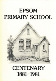
Book - EPSOM PRIMARY SCHOOL CENTENARY 1881-1981, 1981
Epsom Primary School Centenary 1881-1981. Photographs, illustrations and map. 80 pages. With Indexschool, centenary, epsom, education primary school centenary epsom history scholars teachers mothers' club honor roll 1914-1918 war township epsom salts, hotels, progress association, ww1, ww2, vineyards, palm trees, store, ascot park, local families, businesses, sports -
 Stratford and District Historical Society
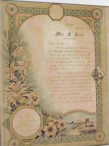
Illuminated Address
Fanny Swan (formerly Wood, nee Poole) came to Gippsland in the 1840s with her first husband, William Wood, where they became proprietors of the Shakespeare Hotel at Stratford. William Wood died in 1855, and in 1856 she married Samuel Swan. Together they acquired considerable property in and around Stratford. Samuel Swan died in 1880 at Stratford, and Fanny Swan died at Stratford in 1895.This illuminated address which documents the final payment for the Wesleyan Church building in 1892 has historic significance for Stratford Historical Society as it is located in the actual building. It also has social significance for the township as Mrs Fanny Swan was one of the earliest and best known business leaders in the area running the iconic Shakespeare hotel/boarding house for many years. It has aesthetic significance as an example of a illuminated address produced on a printing press with gold ink, rather than the usual handwritten form. White wooden frame containing an illuminated address to Mrs S. Swan from the Wesleyan Church at Stratford 2 January 1892. It is press-printed in gold ink on what appears to be a blank, pre-printed poster. It reads: Stratford, 2 January 1892 Mrs S. Swan, Stratford Dear Madam, We, the Minister and Trustees of the Stratford Wesleyan Methodist Church desire to tender you our most sincere thanks for your very generous donation of Fifty Pounds handed to us to-day by Mr George Poole in aid of clearing off the debt on our church. Thanks to your kindness the Ladies of our congregation have been induced to help, and they have raised a considerable sum by means of a Cake and Apron Sale, so that after our Annual Tea meeting to be held at Easter next at our Church. Debt will then be a "Thing of the Past". We trust God will keep you in health and strength, long to live amongst us. We are Yours Very Tuly Rev. H.E. MERRIMAN, Minister Trustees S.CAVANAGH W.LITTLE S.CHINN G.LITTLE Fred J. LITTLE, Secretaryswan, women, methodist church -
 Myrtleford and District Historical Society
Butter Churn
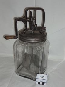
The churn was used by Elise Weston (nee Trahair) at Barwidgee Creek and Myrtleford in the immediate post-war period. Prior to this time it was in the possession of the Trahair family on their family farm where a small dairy herd met family requirements.The churn represents an aspect of self sufficient living in rural areas outside township boundaries. It assisted households to meet family needs using simple processing technology and more so when surplus butter could be sold on in local markets.An upright clear-glass butter churn with screw-on metal cap, handle and gears. The churn mechanism is fully enclosed. "Daisy" brand with "3Qt" inscribed in the glass.glass butter churn -
 Wangaratta Historical Society
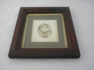
Framed Photo of William Clarke, William Clarke
The photo shows "William Clarke" who owned and operated the first commercial Punt across the Ovens River during the goldrush daysthe photograph shows "William Clarke" who was one of the first pioneers of the township of Wangaratta as it is now known. He also built one of the first hotels in Wangaratta.Brown wooden framed photograph, greyish background with silver surround around photo of William Clarke, one of Wangaratta's foundation pioneers. The wood is from the first punt. He was the owner of the first punt to cross the Ovens river, which he had built for 500 pounds. It was sunk in 1855 after the first bridge across the Ovens river was built.William Clarke1 1839 Wangaratta William Clarke 11 William Clarke 111(my father) Nell Clarke 1884-1965 William Clarke 1 Pioneer of Wangaratta Vic. 1839 This frame is made of oak from the punt he operated over the Ovens River during the goldrush days to Beechworthclarke family, punt, sydney hotel -
Clunes Museum
Booklet, ROBERT CAMPBELL, CLUNES STREETS AND THEIR ORIGINS
HISTORY OF STREET NAMES OF CLUNESSOFT COVER IN RED COLOUR. 14 PAGESnon-fictionHISTORY OF STREET NAMES OF CLUNESclunes street, township of clunes -
Tatura Irrigation & Wartime Camps Museum
Archival File, Rodney Shire Townships c 1886
Grey archival file containing plastic sleeves with photos of Tatura in the early days. -
Tatura Irrigation & Wartime Camps Museum
Book, No Parallel
Partially funded by Australian Bicentennial Authority to celebrate Australian Bicentenary, 1988. Deals with development of the region over the century.Green, illustrated dust cover, relating to early days. Printing in yellow. Plain green hard covercommunity formation, townships, 1914-18 war -
 Hume City Civic Collection
Photograph, c Early 1990's
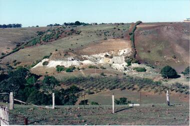
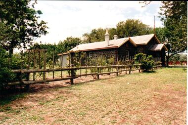
The Kaolin quarries at Bulla were an important industry in the district and supplied clay products to the Cornwell and Hoffman companies in Brunswick. The Kaolin deposits were found in the 1850's and were considered to be some of the largest in the colony.A landscape photograph of a valley with a post and wire fence and a partial view of a farm gate in the immediate foreground. A clump of native trees are on the LHS and a small grove of almond trees has been planted on the river flat. Kaolin quarry is on the hillside and two buildings can be seen on the hill top. High tension pylons are in the distance near the skyline.kaolin quarries, almond groves, bulla township, deep creek, hoffmans kaolin mine, hoffmans potteries, cornwell potteries, george evans collection -
 Hume City Civic Collection
Photograph
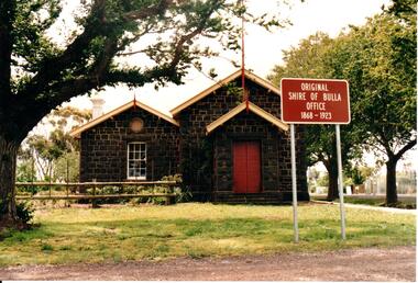
The former bluestone Bulla Shire Hall building was constructed in 1867 and remained the centre of local government until the early 20th century when the administration was moved to Sunbury. In the 1990's the Alister Clark Rose Garden was established in the surrounding grounds. The garden is open to the public all the year round. In 1999 the rose garden was officially opened.A coloured photograph of the front elevation of the original Shire of Bulla offices. It is a bluestone building, double fronted with a pitched roof on both wings and above the porch. The woodwork trims have been painted in cream and red. The double wooden front door is painted red. The sign outside the building indicates the former function of the building and its importance.ORIGINAL/SHIRE OF BULLA/OFFICE/1868-1923shire of bulla, council chambers, rose gardens, rose growing, bulla township, roses, clark, alistair, george evans collection -
 Hume City Civic Collection
Photograph
The former bluestone Bulla Shire Hall building was constructed in 1867 and remained the centre of local government until the early 20th century when the administration was moved to Sunbury. In the 1990's the Alistair Clark Rose Garden was established in the surrounding grounds. The garden is open to the public all the year round. In 1999 the rose garden was officially opened.A coloured photograph of the side garden and the bluestone building which was the shire offices of the former Shire of Bulla. A treated pine fence runs along the front of the property. The roses in the garden are supported with the stakes and there is a backdrop of trees behind the building.shire of bulla, council chambers, rose gardens, rose growing, roses, bulla township, clark, alistair, george evans collection -
 Hume City Civic Collection
Photograph, early 1980s
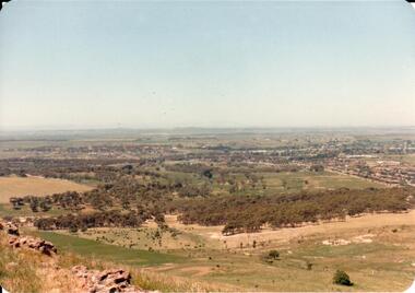
The photograph shows the extent of Sunbury's development to the west of the town in the early 1980s. The settlement at this stage extended along either side of Gap Road for about 0.5 km beyond Elizabeth Drive.A coloured landscape photograph with rounded corners taken from Mt. Holden and looking towards the expanding town of Sunbury. The Melba Avenue drain which flows into Blind Creek is in the foreground. Sheoak Hill, the site of the former Sunbury Asylum is in the middle of the skyline.sunbury township, reservoir road, mt. holden, sunbury asylum, george evans collection -
 Hume City Civic Collection
Photograph, early 1980s
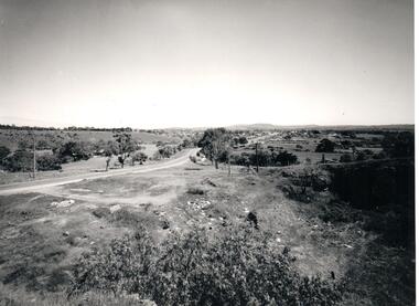
The Headland Estate housing development began in the early 1980s. It was situated west of Sunbury and was bounded by Elizabeth Drive, Reservoir Road, Phillip Drive and Stewart's Lane.A coloured landscape photograph with rounded corners of a view of Sunbury overlooking the Headland Estate before its development. There is a rocky outcrop on the LHS of the photograph and a lightly timbered area in the middle distance. Sunbury can be seen in the distance.headland estate, mt. holden, sunbury township, george evans collection -
 Hume City Civic Collection
Photograph, Early 1970s
A panoramic view of Sunbury looking west.sunbury township, macedon street, george evans collection -
 Hume City Civic Collection
Photograph, 1980s
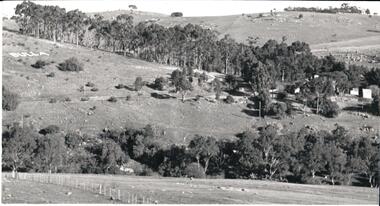
This photograph was taken from the intersection of Loemans and Sunbury Roads. It overlooks the site of the former Bula Primary School and the hillside where stones were laid and painted to form the words "Bulla". The lettering was possible a project carried out by the pupils at the school.A black and white photograph of a panoramic view overlooking the former Bulla Primary School. The photograph has been taken from the intersection of Loemans and Sunbury Roads.bulla primary school, bulla township, george evans collection -
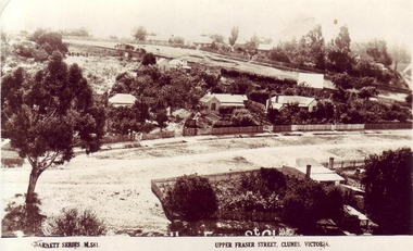 Clunes Museum
Photograph, VALENTINE & SONS PUBLISHING CO.LTD MELBOURN, SYDNEY, BRISBANE
PANORAMIC VIEW OF UPPER FRASER STREET, CLUNESMERRY CHRISTMAS TO ALL FROM CARIN CLUNES.YAlocal history, photography, photographs, clunes township, upper fraser street. -
Clunes Museum
Photograph - PHOTOGRAPHY, PUBLISHED BY E. BARNETT, SNAPSHOTS OF CLUNES
THE PHOTOGRAPHS ARE; SOLDIERS MONUMENT, PORT PHILIP GOLD MINE, TULAROOP CREEK, TOWN HALL, PANORAMA, QUEEN'S WALK, BRIDGE, POST OFFICE,&TOWN HALL,STATE SCHOOL.9 FOLD OUT SNAP SHOTS OF CLUNES, PRESENTED IN FOLDERlocal history, photography, photographs, clunes township -
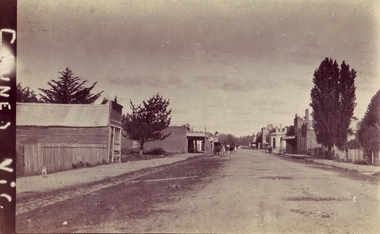 Clunes Museum
Photograph, CIRCA 1860 - 1892
THE DONOR OF THIS PHOTOGRAPH IS A DESCENDENT OF J.S. MULCAHY, BOOT STORE. FRASER STREET. 1860- 1892PHOTOGRAPH OF FRASER STREET, LOOKING TOWARDS THE EAST END, AND THE ANZ BANK. THE RED BOOT PALACE IS FIRST 2 STOREY BUILDING ON THE RIGHT.CLUNES VIC.shops, red boot palace, clunes township -
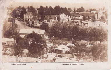 Clunes Museum
Photograph
POSTCARD OF PANOMARA OF CLUNES BARNES SERIES M 580local history, photography, photographs, clunes township -
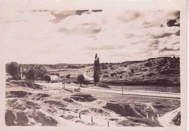 Clunes Museum
Photograph, 1939
THIS PHOTOGRAPH WAS TAKEN AT EASTER CENTENARY CELEBRATION 1939ORIGINAL PHOTOGRAPH, STATION FLAT CLUNES, INCLUDING PORT PHILIP MINE WITH SAND HEAPS.STATION FLAT CLUNES 1939local history, photography, photographs, clunes township