Showing 2383 items
matching first place
-
 Eltham District Historical Society Inc
Photograph - Digital Photograph, Marguerite Marshall, Jesse Tree playing the Didgeridoo and Swiss Hang Drum at St Andrews Market, 29 March 2008
Published: Nillumbik Now and Then / Marguerite Marshall 2008; photographs Alan King with Marguerite Marshall.; p175 It’s Saturday morning and thousands of people are visiting St Andrews Market at the corner of Heidelberg-Kinglake Road and Proctor Street. It’s hard to find a park. Cars are banked up along the narrow road and crammed in a nearby parking area. Yet, at the market, people look relaxed and happy amongst the yellow box gums on the site where the Wurundjeri people used to gather. Stone artefacts unearthed there by Koorie researcher, Isabel Ellender, indicate the site was once a Wurundjeri meeting place, according to Aboriginal Affairs Victoria. Acoustic sounds mingle with quiet conversations. A guitarist blows a mouth organ while his bare toes tickle chimes. A tiny busker, perhaps five years old, plays a violin while sounds of a harp emerge from the hall. One stallholder, selling delicious-looking pastries, chats to another in Spanish, then to me in broad Australian. ‘I was born in Fitzroy but my mother came from Mexico and my dad from Serbia,’ she smiles. A New Zealander fell in love with Mongolia and now imports their hand-made embroidered clothes and Yurts (tents) and runs adventure tours. A young woman visited Morocco and when friends admired the shoes she bought, she decided to import them and sell them at the market. Oxfam sells Fair Trade toys and clothes and displays a petition to Make Poverty History. Other stalls sell Himalayan salt, jewellery made from seeds from northern Australia, glass paper-weights from China as well as locally grown vegetables, flowers and organic freshly baked bread. A woman sits in a state of bliss under the hands of a masseur. Another offers Reiki or spiritual healing. A juggler tosses devil sticks – ‘not really about the devil,’ he smiles. This skill was practised thousands of years ago in Egypt and South America he says. At the Chai Tent people lounge on cushions in leisurely conversation. The idea for the market was first mooted among friends over a meal at the home of famous jazz and gospel singer Judy Jacques.2 Jacques remembers a discussion with several local artists including Marlene Pugh, Eric Beach, Les Kossatz, Ray Newell and Peter Wallace. ‘We decided we wanted a meeting place, where all the different factions of locals could meet on common ground, sell their goodies and get to know one another,’ Jacques recalls. They chose the site opposite another meeting place, St Andrews Pub. A week later Jacques rode her horse around the district and encouraged her neighbours to come along to the site to buy or sell. On February 23, 1973, about 20 stallholders arrived with tables. They traded ‘second-hand clothes, vegetables, meat, cheese, eggs, chickens, goats, scones, tea, garden pots and peacock feathers’. Now around 2000 people visit each Saturday. People usually linger until dusk. The market – with around 150 stalls of wares from a wide variety of cultures – stands alongside Montsalvat as the most popular tourist attraction in Nillumbik. By the 1990s St Andrews Market was in danger of being loved to death, as the site was becoming seriously degraded. The market was spreading in all directions and the degradation with it. A local council arborist’s report in 1994 noted exposed tree roots from erosion and compaction. The Department of Sustainability and Environment threatened to close the market if the degradation was not rectified. After many months of research, discussions and lobbying by a few residents, the council formed a Committee of Management, with an Advisory Committee, and introduced an Environment Levy. The State Government, the council and the market, funded terracing of the site to stop erosion, and retain moisture and nutrients. Vehicles were excluded from some sensitive areas and other crucial zones reserved for re-vegetation. Volunteers planted more than 3000 locally grown indigenous species. The old Yellow Box trees fully recovered and are expected to give shade for many years to come.This collection of almost 130 photos about places and people within the Shire of Nillumbik, an urban and rural municipality in Melbourne's north, contributes to an understanding of the history of the Shire. Published in 2008 immediately prior to the Black Saturday bushfires of February 7, 2009, it documents sites that were impacted, and in some cases destroyed by the fires. It includes photographs taken especially for the publication, creating a unique time capsule representing the Shire in the early 21st century. It remains the most recent comprehenesive publication devoted to the Shire's history connecting local residents to the past. nillumbik now and then (marshall-king) collection, didgeridoo, jesse tree, st andrews market, swiss hang drum -
 Eltham District Historical Society Inc
Photograph - Digital Photograph, Alan King, Alistair Knox Park, Eltham, 2008
Alistair Knox Park, an oasis of peace and beauty. Covered under National Trust of Australia (Victoria) Landscape Significance and Heritage Overlay, Nillumbik Planning Scheme. Published: Nillumbik Now and Then / Marguerite Marshall 2008; photographs Alan King with Marguerite Marshall.; p173 It is hard to imagine that the Alistair Knox Park, an oasis of peace and beauty beside busy Main Road, Eltham, was once the township’s rubbish dump. It was only in the 1970s that the tip was transformed into this beautiful six hectare space, which later earned it a National Trust Landscape classification. Before its life as a dump, the area was used for small farms. Thanks largely to the foresight and efforts of local environmental builder Alistair Knox, the park was designed sympathetically with the character of the wider Eltham landscape. Then, appropriately, the park was named after Knox, who was an Eltham Shire Councillor from 1971 to 1975 and Shire President in 1975. The park designers were four major forces in the urban bush landscape garden –Knox, landscape designer Gordon Ford, artist Peter Glass and landscaper Ivan Stranger. The National Trust citation for the park, originally called Eltham Town Park, includes the Eltham railway trestle bridge and the Shillinglaw Cottage. The citation states ‘the semi-natural setting of the parkland provides a landscape which is evocative of the history of the area’. Manna Gums (Eucalyptus viminalis) and Candlebarks (Eucalyptus rubida) are significant features. Most of the park’s construction was directed by Bob Grant, Superintendent of the Parks and Gardens Department for the Eltham Shire Council. First plantings occurred in Arbour Week in 1973, then the lake and botanic area were completed in 1975, with Federal Government funding, and the toilet block in 1978. Bounded by the Eltham railway line, Panther Place, Main Road, Bridge and Susan Streets, the park is in a valley about a kilometre wide overlooked by steep hills at the east and west. The Diamond Creek flows through it and the picturesque historic timber trestle railway bridge edges the north. Informal plantings of Australian indigenous and native species in open and undulating grassed settings blend with the natural landscape of the Diamond Creek to the west. The bush-style plants, particularly around the creek, balance with open lawns, paths and a cascade flowing from a small lake to another below. A footbridge over the creek leads to the park’s west. The park includes an adventure playground and barbecue areas. The park stands on part of the land bought from the Crown in 1851 by Josiah Holloway, who subdivided it into allotments and which he called Little Eltham. Most of the land was subdivided into residential lots, but the creek valley, on which the park stands, was subdivided into farm-size lots, used mainly for orchards and grazing. One of the earliest owners was John Hicks Petty, who in 1874 bought a plot from Holloway. Other families who owned properties in that area, included Rees, Clark, Waterfall, Graham, Hill and Morant. In 1901 the railway was built through the area. Jock Read, an Eltham resident since around 1920, remembers several farms in the 1920s and ’30s that occupied the site of today’s park. A poultry farm, which extended from present day Panther Place, was owned by the Gahan family. Next to that farm was another for grazing cattle owned by Jack Carrucan. Beside this was land owned by John Lyon. A doctor lived beside this, and at the north-west corner of Bridge Street and Main Road stood a memorial to the soldiers who died in World War One, which was later moved to the RSL site. Mr Read also remembers other farms and orchards west of the creek In the early 1960s the Eltham Council began buying these farms and in the late 1960s turned the areas east of the Diamond Creek into a garbage tip. When this was filled above the creek’s flood plain, the tip was moved to the west of the creek.This collection of almost 130 photos about places and people within the Shire of Nillumbik, an urban and rural municipality in Melbourne's north, contributes to an understanding of the history of the Shire. Published in 2008 immediately prior to the Black Saturday bushfires of February 7, 2009, it documents sites that were impacted, and in some cases destroyed by the fires. It includes photographs taken especially for the publication, creating a unique time capsule representing the Shire in the early 21st century. It remains the most recent comprehenesive publication devoted to the Shire's history connecting local residents to the past. nillumbik now and then (marshall-king) collection, alistair knox park, eltham -
 Eltham District Historical Society Inc
Photograph - Digital Photograph, Alan King, Blue Lake, Plenty Gorge Park, 2008
A quarry was transformed into the Blue Lake. Published: Nillumbik Now and Then / Marguerite Marshall 2008; photographs Alan King with Marguerite Marshall.; p179 The dramatic steep-sided Plenty Gorge lies along the divide of two geological areas, and separates the Nillumbik Shire and the City of Whittlesea. On the Nillumbik side are undulating hills and sedimentary rock, and in Whittlesea, lies a basalt plain formed by volcanic action up to two million years ago. This provides the Plenty Gorge Park with diverse vegetation and habitats, making it one of Greater Melbourne’s most important refuges for threatened and significant species. The park, established in 1986, consists of around 1350 hectares, and extends 11 kilometres along the Plenty River, from Greensborough to Mernda. It provides a wildlife corridor for around 500 native plant and 280 animal species. The area’s plentiful food and water attracted the Wurundjeri Aboriginal people and then European settlers. By 1837 squatters had claimed large runs of land for their sheep and cattle. The Plenty Valley was among the first in the Port Phillip District to be settled - mainly in the less heavily timbered west - and was proclaimed a settled district in 1841.But by the late 1880s, the settlers’ extensive land clearing for animal grazing, then agriculture, depleted the Wurundjeri’s traditional food sources, which helped to drive them away. Many Wurundjeri artefacts remain (now government protected), and so far 57 sites have been identified in the park, including scarred trees, burial areas and stone artefacts. Pioneer life could be very hard because of isolation, flooding, bushfires and bushrangers. Following the Black Thursday bushfires of 1851, basalt was quarried to build more fire-resistant homes. Gold discoveries in the early 1850s swelled the population, particularly around Smugglers Gully; but food production made more of an impact. In the late 1850s wheat production supplanted grazing. In the 1860s the government made small holdings available to poorer settlers. These had the greatest effect on the district, particularly in Doreen and Yarrambat, where orchards were established from the 1880s to 1914. Links with a prominent early family are the remains of Stuchbery Farm, by the river’s edge bounded by Smugglers Gully to the north and La Trobe Road, Yarrambat, to the east. The Stuchberys moved to the valley in 1890, and the family still lives in the area. In 1890, Alfred and Ada first lived in a tent where four children were born, then Alfred built the house and outbuildings around 1896. They planted an orchard, then a market garden, and developed a dairy. The family belonged to the local Methodist and tennis communities. Their grandson Walter, opened the Flying Scotsman Model Railway Museum in Yarrambat, which his widow, Vi, continues to run. Wal was also the Yarrambat CFA Captain for 22 years until 1987. Walter sold 24 hectares in 1976 for development - now Vista Court - and in 1990, the remaining 22.6 hectares for the park. Remaining are an early stone dairy and remnants of a stone barn, a pig sty and a well. Until it was destroyed by fire in 2003, a slab hut stood on the Happy Hollow Farm site, at the southern end of the park. The hut is thought to have been built in the Depression around 1893. This was a rare and late example of a slab hut with a domestic orchard close to Melbourne. Emmet Watmough and his family first occupied the hut, followed by a succession of families, until the Bell family bought it around 1948. There they led a subsistence lifestyle for 50 years, despite encroaching Melbourne suburbia. The Yellow Gum Recreation Area includes the Blue Lake, coloured turquoise at certain times of the year. Following the 1957 bushfires, this area was quarried by Reid Quarries Pty Ltd for Melbourne’s first skyscrapers, then by Boral Australia. However in the early 1970s water began seeping into the quarry forming the Blue Lake and the quarry was closed. The State Government bought the site in 1997 and opened it as a park in 1999.This collection of almost 130 photos about places and people within the Shire of Nillumbik, an urban and rural municipality in Melbourne's north, contributes to an understanding of the history of the Shire. Published in 2008 immediately prior to the Black Saturday bushfires of February 7, 2009, it documents sites that were impacted, and in some cases destroyed by the fires. It includes photographs taken especially for the publication, creating a unique time capsule representing the Shire in the early 21st century. It remains the most recent comprehenesive publication devoted to the Shire's history connecting local residents to the past. nillumbik now and then (marshall-king) collection, blue lake, plenty gorge park -
 Eltham District Historical Society Inc
Photograph - Digital Photograph, Marguerite Marshall, Stuchbery Farm dairy, 14 March 2008
Stuchbery Farm was situated on the Plenty River bounded by Smugglers Gully to the north and La trobe Road, Yarrambat, to the east. Alan and Ada Stutchbery moved to the valley in 1890, first living in a tent where four children were born. Alfred built a home and outbuildings around 1896. They planted an orchard, then a market garden and developed a dairy. Published: Nillumbik Now and Then / Marguerite Marshall 2008; photographs Alan King with Marguerite Marshall.; p179 The dramatic steep-sided Plenty Gorge lies along the divide of two geological areas, and separates the Nillumbik Shire and the City of Whittlesea. On the Nillumbik side are undulating hills and sedimentary rock, and in Whittlesea, lies a basalt plain formed by volcanic action up to two million years ago. This provides the Plenty Gorge Park with diverse vegetation and habitats, making it one of Greater Melbourne’s most important refuges for threatened and significant species. The park, established in 1986, consists of around 1350 hectares, and extends 11 kilometres along the Plenty River, from Greensborough to Mernda. It provides a wildlife corridor for around 500 native plant and 280 animal species. The area’s plentiful food and water attracted the Wurundjeri Aboriginal people and then European settlers. By 1837 squatters had claimed large runs of land for their sheep and cattle. The Plenty Valley was among the first in the Port Phillip District to be settled - mainly in the less heavily timbered west - and was proclaimed a settled district in 1841. But by the late 1880s, the settlers’ extensive land clearing for animal grazing, then agriculture, depleted the Wurundjeri’s traditional food sources, which helped to drive them away. Many Wurundjeri artefacts remain (now government protected), and so far 57 sites have been identified in the park, including scarred trees, burial areas and stone artefacts. Pioneer life could be very hard because of isolation, flooding, bushfires and bushrangers. Following the Black Thursday bushfires of 1851, basalt was quarried to build more fire-resistant homes. Gold discoveries in the early 1850s swelled the population, particularly around Smugglers Gully; but food production made more of an impact. In the late 1850s wheat production supplanted grazing. In the 1860s the government made small holdings available to poorer settlers. These had the greatest effect on the district, particularly in Doreen and Yarrambat, where orchards were established from the 1880s to 1914. Links with a prominent early family are the remains of Stuchbery Farm, by the river’s edge bounded by Smugglers Gully to the north and La Trobe Road, Yarrambat, to the east. The Stuchberys moved to the valley in 1890, and the family still lives in the area. In 1890, Alfred and Ada first lived in a tent where four children were born, then Alfred built the house and outbuildings around 1896. They planted an orchard, then a market garden, and developed a dairy. The family belonged to the local Methodist and tennis communities. Their grandson Walter, opened the Flying Scotsman Model Railway Museum in Yarrambat, which his widow, Vi, continues to run. Wal was also the Yarrambat CFA Captain for 22 years until 1987. Walter sold 24 hectares in 1976 for development - now Vista Court - and in 1990, the remaining 22.6 hectares for the park. Remaining are an early stone dairy and remnants of a stone barn, a pig sty and a well. Until it was destroyed by fire in 2003, a slab hut stood on the Happy Hollow Farm site, at the southern end of the park. The hut is thought to have been built in the Depression around 1893. This was a rare and late example of a slab hut with a domestic orchard close to Melbourne. Emmet Watmough and his family first occupied the hut, followed by a succession of families, until the Bell family bought it around 1948. There they led a subsistence lifestyle for 50 years, despite encroaching Melbourne suburbia. The Yellow Gum Recreation Area includes the Blue Lake, coloured turquoise at certain times of the year. Following the 1957 bushfires, this area was quarried by Reid Quarries Pty Ltd for Melbourne’s first skyscrapers, then by Boral Australia. However in the early 1970s water began seeping into the quarry forming the Blue Lake and the quarry was closed. The State Government bought the site in 1997 and opened it as a park in 1999.This collection of almost 130 photos about places and people within the Shire of Nillumbik, an urban and rural municipality in Melbourne's north, contributes to an understanding of the history of the Shire. Published in 2008 immediately prior to the Black Saturday bushfires of February 7, 2009, it documents sites that were impacted, and in some cases destroyed by the fires. It includes photographs taken especially for the publication, creating a unique time capsule representing the Shire in the early 21st century. It remains the most recent comprehenesive publication devoted to the Shire's history connecting local residents to the past. nillumbik now and then (marshall-king) collection, ada stuchbery, alan stuchbery, dairy, stuchbery farm, farm buildings, yarrambat, plenty gorge park -
 Eltham District Historical Society Inc
Photograph - Digital Photograph, Alan King, Sign: Clara Southern, Heidelberg School Artists Trail, Main Road, Research, 2008
Warrandyte artist, Clara Southern, features on the Artists Trail. Published: Nillumbik Now and Then / Marguerite Marshall 2008; photographs Alan King with Marguerite Marshall.; p189 Since early in the 20th century this district has attracted artists and other creative people. So much so, that Eltham has been compared to the Left Bank in Paris, New York’s Greenwich Village and London’s Bloomsbury. That is until the 1970s when Eltham rapidly expanded into a suburb. However many artists still flourish not only in Montsalvat, Dunmoochin and the Bend of Islands but elsewhere in Nillumbik. Some artists who have worked or lived in Nillumbik are well-known nationally and internationally. Artists are attracted to the hilly district’s subtle colours, unique light and the Yarra River and Diamond Creek. The railway’s extension to Eltham in 1902 brought artists to paint for the day or to camp. Then many settled in Eltham, perhaps also because the poor quality land, far from the city, was cheap. Following World War Two they found they could build houses and studios cheaply by making their own mud-bricks. The flexible material, with its warm tones blending into the bush, also satisfied their aesthetic sensibilities. As early as 1900, Will Longstaff, known for his painting The Ghosts of Menin Gate at the National War Memorial in Canberra, lived at Stanhope in Peter Street, Eltham, later to become the home of intellectuals Clem and Nina Christensen. Members of Australia’s first significant art movement, the Heidelberg School of Artists, painted in Eltham, Warrandyte and Diamond Creek. Walter Withers lived at the corner of Bolton and Brougham Street, Eltham and taught Sir Hans Heysen, who for a short while stayed with the Withers family. In Warrandyte were Clara Southern, whom Frederick McCubbin taught at the National Gallery School and Penleigh Boyd, who is represented in all Australian state galleries and the National Collection in Canberra. May Vale, daughter of politician William, lived in Diamond Creek. With Jane Price they feature on the Heidelberg School Artists Trail, part of which runs through Nillumbik. The trail includes signs each displaying a reproduction of a painting by an artist and located near where the artist lived or painted. In Nillumbik the trail includes parts of Warrandyte, Eltham in the Alistair Knox Park, Main Road shopping precinct and Wingrove Park, the Research walking track on Main Road and the Diamond Creek Reserve. In 1916 artist William ‘Jock’ Frater lived at the corner of Arthur and Bible Streets, Eltham. Before then, Frater, with other artists including Percy Leason (who moved to Eltham in the mid 1920s) painted in Eltham on weekends. They camped near Bible and Pitt Streets and along the Diamond Creek where the Eltham Retirement Centre now stands.4 In 1921, painter Peter Newbury (father to painter David Newbury, who was born in Eltham) moved to Cromwell Street, Eltham. Max Meldrum, the first Australian painter to formulate a consistent theory of art largely based on tone,5 taught local artists Alan Martin, Clarice Beckett, Peter Glass and Justus Jörgensen. Meldrum visited Eltham then rented a house there for 18 months opposite Wingrove Park. In 1934, artist and architect Justus Jörgensen and his doctor wife Lil and friends built Montsalvat, the artists’ colony. Montsalvat has played an important part in attracting artists to Eltham and its mud-brick, pisé, stone and recycled building materials has had a major influence on Eltham’s built environment. Jörgensen’s students who also helped him build Monstalvat included Arthur Munday, Lesley Sinclair, Helen Lempriere, Joe Hannan, Helen, Sonia and jeweller/sculptor, Matcham Skipper. Among artists who visited Montsalvat were Clifton Pugh and Angry Penguins’ artists Albert Tucker and Arthur Boyd. Some who painted after World War Two were Alan Martin of Eltham and Warrandyte artists Frank Crozier and Harry De Hartog6, one of Melbourne’s first painters influenced by Cubism.This collection of almost 130 photos about places and people within the Shire of Nillumbik, an urban and rural municipality in Melbourne's north, contributes to an understanding of the history of the Shire. Published in 2008 immediately prior to the Black Saturday bushfires of February 7, 2009, it documents sites that were impacted, and in some cases destroyed by the fires. It includes photographs taken especially for the publication, creating a unique time capsule representing the Shire in the early 21st century. It remains the most recent comprehenesive publication devoted to the Shire's history connecting local residents to the past. nillumbik now and then (marshall-king) collection, clara southern, main road, research (vic), heidelberg school artists trail -
 Falls Creek Historical Society
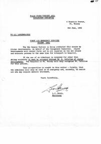
Letter - First Aid Emergency Services Season
Bob (Herman) Hymans (a former member of the Royal Netherlands Navy) was born in Bloemendaal, Holland on 30th September 1922. During World War II he fought against the Japanese in the Dutch East Indies (now Indonesia) and was imprisoned in Changi and on the Burma Railway. After gaining qualifications as a Ski Instructor, Bob arrived in Falls Creek in July 1950. Working as an Instructor and Supervisor at Bogong Lodge, Bob decided his future was in accommodation. He was successful in negotiating an indenture for land from the State Electricity Commission (SEC). It took Bob two years to build his Grand Coeur Chalet but, tragically, it was burned down in August 1961. Bob also built the first Chairlift in Australia. This was a single chairlift and the structure was built from wooden electricity poles. He was constantly full of new ideas and proposals for the village. Bob Hymans died on 7th July 2007. This Collection of documents and letters tells the story of Bob's endeavours to develop Falls Creek into the ski village it is today.This letter is significant because it documents procedures put in place by the Falls Creek Tourist Area Management Committee for safe functioning of the area under its jurisdiction.A letter from the Management Committee outlining procedures established for First Aid Emergency Services during the upcoming snow season.falls creek tourist area management committee, medical facilities falls creek 1961 -
 Falls Creek Historical Society
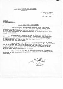
Letter - Garbage Clearances 1961 Winter
Bob (Herman) Hymans (a former member of the Royal Netherlands Navy) was born in Bloemendaal, Holland on 30th September 1922. During World War II he fought against the Japanese in the Dutch East Indies (now Indonesia) and was imprisoned in Changi and on the Burma Railway. After gaining qualifications as a Ski Instructor, Bob arrived in Falls Creek in July 1950. Working as an Instructor and Supervisor at Bogong Lodge, Bob decided his future was in accommodation. He was successful in negotiating an indenture for land from the State Electricity Commission (SEC). It took Bob two years to build his Grand Coeur Chalet but, tragically, it was burned down in August 1961. Bob also built the first Chairlift in Australia. This was a single chairlift and the structure was built from wooden electricity poles. He was constantly full of new ideas and proposals for the village. Bob Hymans died on 7th July 2007. This Collection of documents and letters tells the story of Bob's endeavours to develop Falls Creek into the ski village it is today.This letter is significant because it documents procedures put in place by the Falls Creek Tourist Area Management Committee fsnd the State Electricity Commission to provide services to the leaseholders at Falls Creek.A letter from the Management Committee dated 26.06.1961 which outlines procedures for the collection of garbage. The service was provided without charge by the State Electricity Commission (SEC) and was to operate twice weekly.falls creek tourist area management committee, falls creek garbage disposal -
 Lakes Entrance Historical Society
Postcard - P.S. Tanjil, 1885 c
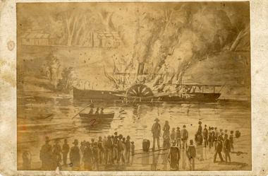
Photo mounted on card. This Tanjil was the first one. Original archived in a safe place because of its fragile condition.Sepia photograph showing painting depicting view of P S Tanjil on fire at Bairnsdale Wharf. People on wharf watching fire, rowing boat on fire, Tanjil at opposite bank, huts above. Bairnsdale Victoriaships and shipping, jetties -
 Warrnambool and District Historical Society Inc.
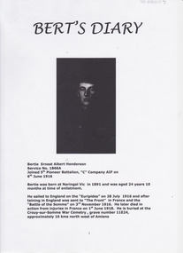
Document - Bert's Diary Bertie Ernest Albert Henderson, Circa 1916
Bertie Ernest Albert Henderson was born at Naringal in 1891 and was 24 at the time of enlistment. He fought in France and died from injuries in France on June 1, 1918. The entries relate to matters which relate to military procedures and duties, places visited in France and England, time spent at the front and on leave.For Australia, as for many nations, the First World War remains the most costly conflict in terms of deaths and casualties. From a population of fewer than five million, 416,809 men enlisted, of which over 60,000 were killed and 156,000 wounded, gassed, or taken prisoner.* Australian War Memorial Website Bertie Henderson was but one of these casualties and this diary gives an insight into the life of the average soldier. He records events from the mundane to conditions common to the war experience. Front page has photograph and typed enlistment details, followed by copy of enlistment paper and numerous pages of typed diary entries dated from July 1916. Other entries give day only with no year. Back cover has basic family tree.warrnambool, naringal, ernest albert henderson, 5th pioneer batallion, world war 1, amiens, crouy-sur somme -
 Kew Historical Society Inc
Photograph - Irena Higgins, 1950s
Born in Poland in 1914, Irena Higgins completed her degree in social work at the University of Lwow [Lvov]. Migrating to Australia in 1938, she lived in various places including in Perth, Brisbane and Sydney before moving with her family to Melbourne in 1945. She initially worked at the Victorian Society for Crippled Children. Then in 1952, Irena was employed as a social worker by the Mental Hygiene Division of the Health Commission at Kew Mental Hospital (which included children). She was the first social worker employed by the Victorian Mental Health Authority to work with children with an intellectual disability. She remained at Kew for seventeen years, becoming Senior Social Worker with a staff of three other social workers, a secretary and a number of aides. Two of Irena’s significant innovations at Kew were the establishment of a Parents’ Association, and the development of a network of volunteers trained to work with families in the community. Irena Higgins remained committed to social reform following her retirement in 1984, working actively to establish the first emergency housing in Kew. In 2015, Irena’s daughter Barbara Higgins, and friend Elizabeth Watts, donated a number of her papers to the Kew Historical Society. These documents constitute the Irena Higgins Collection.Black and white photograph of Irena Higgins, donated by her daughter as part of the Irena Higgins Collection.irena higgins, kew mental hospital - willsmere, children's cottages (kew) -
 Bendigo Historical Society Inc.
Book - STRAUCH COLLECTION: WHROO CEMETERY VICTORIA
Although the first recorded burial at Whroo (7 km south of Rushworth) was in 1858, it is believed earlier unrecorded burial took place. The official cemetery was established in 1860 and contains approx. 400 burials although many are unmarked. There is also a Chinese section as in 1863 17% of the population was Chinese in 1863.Red Spring binder containing list of interments in Whroo Cemetery with maps & illustrations.James & Nicola Thomsonplace, cemetery, whroo, victoria-whroo-rusthworth-history-cemetery -
 Sunbury Family History and Heritage Society Inc.
Photograph, Bulla Presbyterian Church
St.Andrew's Presbyterian Church at Bulla was built on Crown land that the congregation received on 6th September 1858. It overlooks Oaklands Road and the surrounding farms as well as the Tullamarine Airport. The building at the rear is the former manse. It functioned as a place of worship for over 150 years and celebrated its 150th anniversary in 2009. The entire property is now privately owned.It was one of the first permanent church buildings to be built in the district.A non-digital black and white photograph, with a cream border, of a blue-stone church with a high-pitched slate roof and a tall belfry its the main entrance. A smaller residence is visible in the background. The buildings have been erected in an open grassed area.presbyterian church, bulla, oaklands, churches -
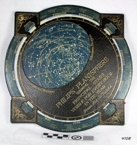 Flagstaff Hill Maritime Museum and Village
Planisphere, Early 20th Century
The word Planisphere (Latin planisphaerium) was originally used in the second century by Claudius Ptolemy to describe the representation of a spherical Earth by a map drawn in the plane. This usage continued into the Renaissance: for example Gerardus Mercator described his 1569 world map as a Planisphere. The word describes the representation of the star-filled celestial sphere on the plane. The first star chart to have the name "Planisphere" was made in 1624 by Jacob Bartsch. Bartsch was the son-in-law of Johannes Kepler, discoverer of Kepler's laws of planetary motionA significant item of celestial mapping used by marine navigators This particular item was made and used in the first quarter to half of the 20th century.Planisphere consists of a circular star chart attached at its centre to an opaque circular overlay that has a clear elliptical window or hole so that only a portion of the sky map will be visible in the window or hole area at any given time. The chart and overlay are mounted so that they are free to rotate about a common pivot point at their centers. The star chart contains the brightest stars, constellations and (possibly) deep-sky objects visible from a particular latitude on Earth. The night sky that one sees from the Earth depends on whether the observer is in the northern or southern hemispheres and the latitude. A Planisphere window is designed for a particular latitude and will be accurate enough for a certain band either side of that. Planisphere makers will usually offer them in a number of versions for different latitudes. Planispheres only show the stars visible from the observer's latitude; stars below the horizon are not included. A complete twenty-four-hour time cycle is marked on the rim of the overlay. A full twelve months of calendar dates are marked on the rim of the star chart. The window is marked to show the direction of the eastern and western horizons. The disc and overlay are adjusted so that the observer's local time of day on the overlay corresponds to that day's date on the star chart disc. The portion of the star chart visible in the window then represents (with a distortion because it is a flat surface representing a spherical volume) the distribution of stars in the sky at that moment for the Planispheres designed location. Users hold the Planisphere above their head with the eastern and western horizons correctly aligned to match the chart to actual star positions. "Sold by J DONNE & SON, Booksellers & Stationers, 349 Post Office Place Melbourne 349. Admiralty Chart Agents" and " Made in Germany for George Philip & Son Ltd" England . Signature "Capt E. B. ?..id, 22 Baund St"flagstaff hill, warrnambool, shipwrecked-coast, flagstaff-hill, flagstaff-hill-maritime-museum, maritime-museum, shipwreck-coast, flagstaff-hill-maritime-village, star map, marine navigation, maps, george philip & sons -
 Bacchus Marsh & District Historical Society
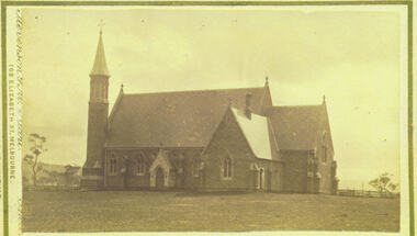
Photograph - Saint Bernard's Roman Catholic Church, Lerderderg Street Bacchus Marsh 1883
This Catholic Church was built between 1872 and 1874. It was the first permanent Catholic Church building in Bacchus Marsh. Catholics had lived in the Bacchus Marsh area since the early 1840s and in this early period religious services had been conducted in a number of different buildings including peoples' homes. This Church still stands and continues to be the main place of worship for Catholics in the Bacchus Marsh area. Small sepia 'carte de viste' style unframed photograph on card with gold border framing photograph. Housed in the Jeremeas Family Album which contains photographs of Bacchus Marsh and District in 1883 by the photographers Stevenson and McNicoll. The image shows Saint Bernard's Catholic Church in Bacchus Marsh nine years after it was erected in 1874. The view of the Church is looking north from somewhere around the present day location of Manor Street Bacchus Marsh. This image was taken before the Presbytery was built in 1889.Printed On the front: Stevenson & McNicoll. Photo. 108 Elizabeth St. Melbourne. COPIES CAN BE OBTAINED AT ANY TIME. On the back: LIGHT & TRUTH inscribed on a banner surmounted by a representation of the rising sun. Copies of this Portrait can be had at any time by sending the Name and Post Office Money Order or Stamps for the amount of order to STEVENSON & McNICOLL LATE BENSON & STEVENSON, Photographers. 108 Elizabeth Street, MELBOURNE. stevenson and mcnicoll 1883 photographs of bacchus marsh and district, churches bacchus marsh, catholic church bacchus marsh, saint bernards roman catholic church bacchus marsh -
 Eltham District Historical Society Inc
Negative - Photograph, Cool Stores, Hurstbridge, 1917
View overlookng Hurstbridge with the Cool Stores complex in the middle of the view (opened in March 1915) surrounded by an orchard of fruit trees. Local orchardists housed their fruits in cold storage here before despatch by rail to domestic and international markets, sometimes out of season.This photo forms part of a collection of photographs gathered by the Shire of Eltham for their centenary project book, "Pioneers and Painters: 100 years of the Shire of Eltham" by Alan Marshall (1971). The collection of over 500 images is held in partnership between Eltham District Historical Society and Yarra Plenty Regional Library (Eltham Library) and is now formally known as 'The Shire of Eltham Pioneers Photograph Collection.' It is significant in being the first community sourced collection representing the places and people of the Shire's first one hundred years.Digital image 4 x 5 inch B&W Negshire of eltham pioneers photograph collection, hurstbridge, cool stores, orchards, cool store -
 Ballarat Tramway Museum
Newspaper, The Courier Ballarat, "Tram No. 18 rides again", 25/03/1985 12:00:00 AM
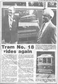
Item about the BTPS launching No. 18 into formal service with its previous owners, the Borough of Sebastopol and a short history of the tram and its life in Ballarat. Has photos of the day.Newspaper clipping, from The Courier, 25-3-1985 titled "Tram No. 18 rides again", about the launch of Ballarat No. 18 into formal service with the Borough Of Sebastopol president. Gives story of the tram and relationship with Council, quotes Frank Hanrahan and Warren Doubleday. Has photo of Frank Hanrahan and Mayor Cr Graham Collins presenting a photo of the tram and photo of the tram breaking streamers leaving the depot. Event took place on 23/3/1985. Article notes that 40 had its first official run since restoration to its bogies. See Reg Item 3829 for the black and white print of No. 18.btps, borough of sebastopol, launch -
 Bacchus Marsh & District Historical Society
Photograph, Border Inn, Main Street Bacchus Marsh 1883
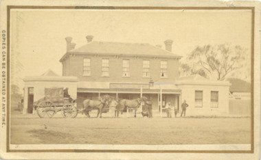
The Border Inn located on the corner of Main Street and Graham Street Bacchus Marsh opened in 1851 making it a very early hotel in Victoria. It was built and owned by John Pilmer. The first licensee was James Watt. The building has been added to and changed many times. It was originally a single storey building. A second storey was added in 1863 by John Pilmer. In 1866 the hotel was purchased by Edward Jones. The Jones family owned and operated the hotel until 1939. Additional second storey sections were added in 1883, 1904 and 1936. For a number of years the Border Inn was a stopping post for coaching services between Melbourne and Ballarat. The first licensee of the hotel James Watt was among the first in Victoria to offer a regular coaching service and his hotel was used for overnight accommodation by coach travellers. At the time this picture was taken coach services were still operating between Bacchus Marsh and other locations. The coach in this picture is possibly one of those coaches.This building has been documented as of state significance by Richard Peterson and Daniel Catrice in their 1995 heritage study for the then Shire of Bacchus Marsh. Their assessment of the heritage significance of the building was: "The Border Inn is of state historical significance as a pioneering pre-gold rush building, on the route to the Ballarat goldfields. It is the representative-embodiment of several historical periods and their way of life. It demonstrates a complex changing sequence of patterns of occupancy and architectural styles. Its development at this location, demonstrates the effect of a social movement, the gold rush, as a transport stopover.It is also historically significant for its association with the first rural public transport in Victoria. Locally, the hotel is significance for its association with the first meeting of municipal government, and also for its social significance as a traditional community, visitor focus and meeting place".Small sepia unframed photograph on card with gold border framing photograph. Housed in the album, 'Photographs of Bacchus Marsh and District in 1883 by Stevenson and McNicoll'. The image shows the Border Inn Hotel at an angle depicting the front of the building facing directly to the camera. It is a two storey brick building, with one-story additions at either end. Five chimneys can be seen extending from the building. The bottom storey has a verandah extending onto the footpath. A covered wagon, probably a coach, with four horses in harness is in front of the building. There are several people in the image. Two people are sitting on the driver’s seat of the wagon. Another man is standing holding the reins of the horses. At his feet is a dog. Behind them are two male adults. One is holding a small child. A young boy stands beside him.On the front: Stevenson & McNicoll. Photo. 108 Elizabeth St. Melbourne. COPIES CAN BE OBTAINED AT ANY TIME. On the back: LIGHT & TRUTH inscribed on a banner surmounted by a representation of the rising sun. Copies of this Portrait can be had at any time by sending the Name and Post Office Money Order or Stamps for the amount of order to STEVENSON & McNICOLL LATE BENSON & STEVENSON, Photographers. 108 Elizabeth Street, MELBOURNE. stevenson and mcnicoll 1883 photographs of bacchus marsh and district, hotels bacchus marsh, border inn hotel bacchus marsh, carriages and coaches, stagecoaches, james watt bacchus marsh, john pilmer bacchus marsh, edward jones family bacchus marsh -
 Ballarat Tramway Museum
Photograph - Colour Photograph/s, Carolyn Dean, March to May 2000
Set of 20 photographs taken by Carolyn Dean of the construction of the new storage sheds at Bungaree and painting of the house during the period 27/3/2000 and 6/5/2000. All on Kodak Paper. .1 - John Phillips concreting at rear of house - 27/3/00 .2 - ditto .3 - Sheds framing - 8/4/00 .4 - ditto .5 - Painting of rear of house - partially done for extensions .6 - ditto .7 - putting the second sheet of cladding on. .8 - ditto, with tower truck in background. .9 - ditto .10 - ditto .11 - Jim Parker painting windows .12 - ditto, painting eaves .13 - ditto .14 - finishing off the wall cladding on the first shed - 9/4/00 .15 - ditto .16 - guttering .17 - ditto .18 - placing roof sheeting on the first shed. .19 - Cladding the second shed - 6/5/00 .20 - wall cladding finished on both sheds.All with dates and "Photo by Carolyn Dean" on rear in blue ink.bungaree, sheds, btm -
 Wodonga & District Historical Society Inc
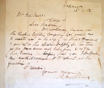
Letter - Electricity comes to Wodonga - 1912 letter to Mrs Beardmore
Mrs Jessie Beardmore, wife of the Shire President, Mr Henry Beardmore, was invited to switch on the electrical current at the power house in Wodonga on 15th January 1912. This was not the official opening of the newly installed system which took place a few weeks later. Disagreement existed amongst Shire Councillors about the official opening, several of them including Mr Beardmore believing the opening should only take place when the scheme was completed. However Dr Schlink, Mr D. M. Stavely, Cr Twomey and Mr C. Holloway, Engineer for the Electric Lighting Company, arranged a small ceremony to turn lights on for the first section of the scheme. This included street lighting along Sydney Street between South Street and the Shire Hall as well as a few business houses and private establishments, with the balcony of the Terminus Hotel illuminated by over 100 lights. Other areas and buildings were connected over the following weeks. Mr Beardmore was not present at the beginning of proceedings but joined the crowd in the street. During a small number of speeches, credit for his work to instigate and further the introduction of electricity to Wodonga was given to Councillor Twomey, referred to as “the father of the scheme”. This item is significant because it records the first connection of electricity to Wodonga in 1912.A hand written letter addressed to Mrs Beardmore of Wodonga. A portrait of Mrs Beardmore is also included. A transcript of the letter is included below. Wodonga 15 -1-12 Mrs Beardmore Wodonga Dear Madam, Mr Holloway, Engineer for the Electric Lighting Company, has invited me to invite you as the wife of the Shire President to switch on the electric supply for the town at the power house not later than 8.30PM (this evening). Hoping that you and Mr Beardmore can make it convenient to attend. I remain yours sincerely, R. H. Schlinkbeardmore family, electricity in wodonga -
 St Vincent's Hospital Melbourne Archives
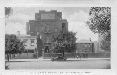
Postcard, C.W. Series, Melbourne, St Vincent's Hospital, Victoria Parade, Fitzroy, Circa 1914
The postcard shows St Vincent's Hospital, on the northern side of Victoria Parade, Fitzroy, circa 1914. At left is the original hospital building, a converted terrace house, alongside the first purpose-built wing opened 1905 and the Cullen Wing (with facilities for medical students and residents) on the right. A group of two men and three boys stands on the footpath outside the Cullen Wing and a car is parked outside the main hospital building in the centre of the photograph. The reverse of the postcard is a letter from a niece to her uncle and aunt detailing their day trip into Melbourne, the places they saw, the people they met and the activities they took part in.This postcard is significant since it provides a rare view of the hospital from this location at this point in its history.Black and white postcard showing photograph of St Vincent's Hospital Melbourne on the front and a letter is written in pencil on the reverse.On the reverse is a handwritten letter in pencil from a niece to her aunt and uncle about a day trip they took into Melbourne. The message is dated January 27, 1914.st vincent's hospital melbourne, streetviews, postcards, hospital buildings, fitzroy -
 Melbourne Tram Museum
Photograph - Black & White Photograph/s, c1925
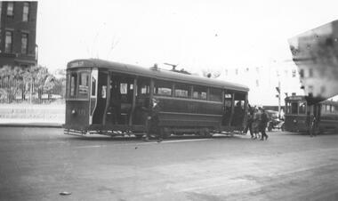
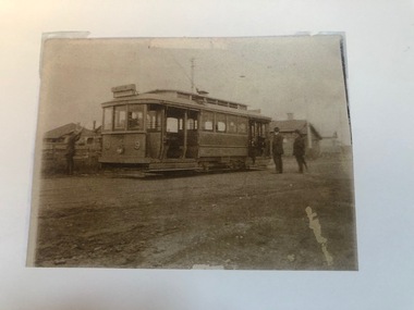
Black and white photograph of 2 trams in Swanston St c1925. Building in background may be the Queen Victoria hospital which places the trams just north of Lonsdale St. Photo has imperfection in top left corner of the image. First tram No. 171 is an S class single-truck California combination tram built by MMTB at Coburg Depot. It entered service in June 1922 and was withdrawn from service and sold in 1953. The tram's destination is shown as "Coburg Cemetery". Several passengers are seen boarding the tram. See page 64 of Destination City 5th Edition for another photo of this tram at South Melbourne Depot. The second tram, 178, is a T class single-truck combination tram with a long saloon, built by Duncan & Fraser, Adelaide for the MBCTT. It entered service in June 1917 as tram number 14C before transfer to the MMTB as T class tram. It was withdrawn from service and sold in 1961. This tram was one of only 6 Melbourne trams fitted with long wheelbase Brill Radiax truck. See page 65 of Destination City 5th Edition for another photo of this tram at Point Ormond terminus.trams, tramways, s class, t class, swanston st, mbctt, tram 171, tram 178, mmtb -
 Melbourne Tram Museum
Photograph - Photograph Card, Keith Kings, Highfield Road terminus, Wattle Park, c2000?
Photograph - copied from an original print using a scanner and then printed on an A4 sheet of HTT 9 (could be 8) at the Highfield Road terminus, Wattle Park, 1925. The conductor is placing the trolley pole. A photocopied caption with the print notes as "The first tram along Riversdale Road to Highfield Road" See image i2 for further notes. Photo from Mrs Doris Turnbull of Essex Road.In pencil on the print "Keith Kings"trams, tramways, wattle park, highfield road, opening, conductors -
 Melbourne Tram Museum
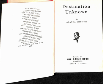
Book, Agatha Christie, "Destination unknown", 1954
Book, hard cover, 12 sections, sewn with end papers, 210 pages, titled "Destination unknown", written by Agatha Christie, published by The Crime Club, 1954. Has the stamp of the Footscray Tramway Library, asking it to be returned within 14 days inside the front cover and in many places throughout the book, along with Number "606" on the inside front cover and on the spine of the book. The book was part of a library run by the depot staff to provide materials during broken shifts and to take home. From Wikipedia - accessed 26/12/2019: Plot summary Hilary Craven, a deserted wife and bereaved mother, is planning suicide in a Moroccan hotel, when she is asked by British secret agent Jessop to undertake a dangerous mission as an alternative to taking an overdose of sleeping pills. The task, which she accepts, is to impersonate the wife of Thomas Betterton, a nuclear scientist who has disappeared and may have defected to the Soviet Union. Soon she finds herself in a group of oddly-assorted travellers being transported to the unknown destination of the title. The destination turns out to be a secret scientific research facility disguised as a modern leper colony and medical research center at a remote location in the Atlas Mountains. The scientists are well-treated, but they are not allowed to leave the facility, and they are locked in secret areas deep inside the mountain whenever government officials and other outsiders visit. Hilary Craven successfully passes herself as Betterton's wife Olive, because he is miserable and wants desperately to escape. Hilary discovers that the facility was built by the fabulously wealthy and somewhat villainous Mr Aristides, for financial rather than political ends. He has lured the world's best young scientists to it with various deceptions so that he can later sell their services back to the world's governments and corporations for a huge profit. She falls in love with Andrew Peters, a handsome young American who was in the group with her on their journey to the facility. With the help of clues she has left along the way, Jessop eventually locates and rescues her and the others held there. Peters turns out also to be on a mission, intent on bringing Betterton to justice for the murder of his first wife. Betterton, revealed to also be a scientific fraud who plagiarized his work, is arrested. Hilary no longer wants to die, and she and Peters are free to begin their life together.On the top of the first page "13/3" indicating the price, "m/arz"? on the bottom left hand corner and inside the front cover the label of "Robertson & Mullens Ltd" booksellers.trams, tramways, footscray depot, libraries, novels, personnel, crews, shifts -
 Melbourne Tram Museum
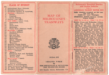
Map, Melbourne & Metropolitan Tramways Board (MMTB), "Map of Melbourne Tramways", 1934
Map booklet consists of three pages of bus and tram round trips, 3 center pages for a map of electric and cable trams, route numbers, and points of interest. Has 4 pages giving an index to routes and first and last trams to and from the City. Shows points where suburban routes are intersected by City routes. One page of places of interest. Dated 1934/35.Demonstrates methods of giving information to visitors to Melbourne and yields information about tram services at the time in Melbourne.Map - 2 octavo cards stapled and folded into 12 pages. All printing is in black with red headings and highlights except for the map which is in four colours.tramways, trams, mmtb, map, timetables, tourist trips -
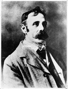
 Eltham District Historical Society Inc
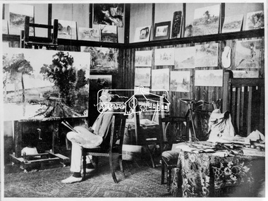
Photograph, Walter Withers in his studio, Eltham, c.1906
Walter Withers (1854-1914) was born in Handsworth, Warwickshire, England. He migrated to Australia in 1882 and in time was to become one of the country's most famous painters. In 1887/8 he spent a year in London and Paris during which time he married Fanny Flinn. When he returned to Melbourne he was engaged by publishers doing black and white illustrations. In the late 1880's he became associated with artists who formed the renowned "Heidelberg School" and in 1890 moved to "Charterisville" at Eaglemont. He lived in the Heidelberg area until 1903 when he purchased a house on two and a half acres (one hectare) at the corner of Brougham and Bolton Streets, Eltham. He had long been attracted to the Eltham area, but needed access to Melbourne for his painting classes. The extension of the railway in 1901 made the move possible. He remained in Eltham until his death and is buried at nearby St Helena. Many of his important paintings were painted during these later years. There are important collections at the National Gallery of Victoria and the Geelong Art Gallery. His Eltham house remains and his name is honoured by a small park at the corner of Bible and Arthur Streets. Source: Information panel produced for Heritage Display exhibition by EDHS 1990.This photo forms part of a collection of photographs gathered by the Shire of Eltham for their centenary project book,"Pioneers and Painters: 100 years of the Shire of Eltham" by Alan Marshall (1971). The collection of over 500 images is held in partnership between Eltham District Historical Society and Yarra Plenty Regional Library (Eltham Library) and is now formally known as the 'The Shire of Eltham Pioneers Photograph Collection.' It is significant in being the first community sourced collection representing the places and people of the Shire's first one hundred years.Digital image 4 x 5 inch B&W Neg (duplicate of original)eltham local characters, pioneers and painters, sepp, shire of eltham pioneers photograph collection, walter withers, eltham, southernwood -
 Eltham District Historical Society Inc
Negative - Photograph, Walter Withers, c.1903-1914
Walter Withers (1854-1914) was born in Handsworth, Warwickshire, England. He migrated to Australia in 1882 and in time was to become one of the country's most famous painters. In 1887/8 he spent a year in London and Paris during which time he married Fanny Flinn. When he returned to Melbourne he was engaged by publishers doing black and white illustrations. In the late 1880's he became associated with artists who formed the renowned "Heidelberg School" and in 1890 moved to "Charterisville" at Eaglemont. He lived in the Heidelberg area until 1903 when he purchased a house on two and a half acres (one hectare) at the corner of Brougham and Bolton Streets, Eltham. He had long been attracted to the Eltham area, but needed access to Melbourne for his painting classes. The extension of the railway in 1901 made the move possible. He remained in Eltham until his death and is buried at nearby St Helena. Many of his important paintings were painted during these later years. There are important collections at the National Gallery of Victoria and the Geelong Art Gallery. His Eltham house remains and his name is honoured by a small park at the corner of Bible and Arthur Streets. Source: Information panel produced for EDHS exhibition in 1990.This photo forms part of a collection of photographs gathered by the Shire of Eltham for their centenary project book,"Pioneers and Painters: 100 years of the Shire of Eltham" by Alan Marshall (1971). The collection of over 500 images is held in partnership between Eltham District Historical Society and Yarra Plenty Regional Library (Eltham Library) and is now formally known as the 'The Shire of Eltham Pioneers Photograph Collection.' It is significant in being the first community sourced collection representing the places and people of the Shire's first one hundred years.Digital image 4 x 5 inch B&W Neg 120 format B&W negative B&W printsepp, shire of eltham pioneers photograph collection, eltham, walter withers, artist -
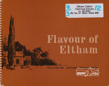 Eltham District Historical Society Inc
Book, Flavour of Eltham : recipes and other items collected by friends of the Shillinglaw Cottage, 1964
Flavour of Eltham: recipes and other things was collected and published by the Friends of Shillinglaw Cottage in 1964. The original cottage once stood about 100 metres away from its current location in Panther Place, Eltham. Built in the 1870’s, it is one of Eltham’s earliest buildings. In 1963 it faced demolition to make room for the Eltham Shire offices. But local residents came together to save the cottage. It was the first time that an early settler’s brick building was removed and reconstructed. A fundraiser was the resident’s compilation of loved recipes into the cookery book Flavour of Eltham. It also includes illustrations and advertisements for local buisnesses. The foreword of the book states: “This book is about Eltham. But more than that it is about intention. It originated when the people of Eltham, the first in Australia to preserve the reconstruction an historical building, removed and rebuilt a cottage that reflected the spirit of a period. The shilling law cottage was first built in 1859 and was rebuilt in 1964. It has beauty and is rich with the past. The people of Eltham stand for something. There is, in this community, a firm resolve to preserve for their children the natural beauty of the district; to establish a centre whose allegiance is to aesthetic values rather than to commercial ones. Eltham already has this reputation, a reputation that is known beyond the borders of Australia. Its desire is to increase it. This book is a step forward in that direction.” October 1964. Signed Alan Marshall The chapters include: Old time, Restaurants, are you in a hurry, Advance action, Serve it cold, Tea time tanstalizer, Pickles and preserves, Fabulous fare and Ne Buvez Jamais L’eau. The cover illustration was drawn by Peter Glass, First Edition: November 1964, Second Edition: January 1965, Third Edition: August 1965, Fourth Edition: August 1968 Additonal souce: Marshall, Marguerite, Nillumbik Now and Then, MPrint Publications, 2008Paperback; 116 p. : ill. ; 18 x 23 cm.shillinglaw cottage, cooking, recipes, cookery, friends of shillinglaw cottage -
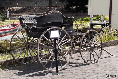 Flagstaff Hill Maritime Museum and Village
Vehicle - Murweh Carriage, c.1874
This private late-nineteenth-century four-wheeled carriage has been built to transport a family or group of passengers with a coachman in the front seat. It can be pulled by one horse, or by two horses if the T-pole is attached. The button fittings along each side of the carriage indicate that a folding roof or hood was once attached. The frame across the front of the carriagewas likely to have been a ‘dashboard’ with a leather or wood covering to prevent water, mud and other particles from splashing onto the passengers. The rear step between the two side-facing bench seats is adjustable to allow for ladies’ long skirts. These rear seats appear to be removable, in which case the carriage could be converted to a wagon to transport goods and equipment. The carriage could have been illuminated by oil or carbide lamps placed into the lamp holders on the sides. The carriage was kept under cover for many years in an open-front sandstone building that also included living quarters and an area that may have been stable. It was at ‘Murweh’ a Warrnambool property at 203 Liebig Street. The home is now Heritage and National Trust Listed and described as a ‘gentleman’s residence’. It was built by James Wotton Shevill in the 1860s. Shevill was a councillor from 1875 to 1878, serving in 1878 as Mayor of the Borough of Warrnambool. Jeremiah Wade lived at Murweh there from 1879-1880. By 1915 F.B. Whitehead and his family were living there, and by 1930 the address was used by Mr T.J. Rome and his family. Thomas James Rome was still using that address in September 1973 after his 100th birthday. It is believed that one of the property’s owners had been an Obstetrician in Warrnambool. The current owner re-told the story that children used to hide in the back section of the carriage and smoke, hidden from the sight of onlookers. He had heard the story from a previous owner.The well-appointed horse-drawn four-wheeled carriage is likely to have first belonged to a local councillor and past Mayor of the town of Warrnambool, J.W. Shervill, whose 1860s city property was the carriage location for many years. The carriage is a rare local example of a town-based lifestyle befitting a prosperous personality of the late 19th century. It adds to the story of Warrnambool's development as a town influenced by the port, wealth gained from shipping and the home place of prominent local people such as the Councillor and later Mayor. The side-facing rear seating is unusual for a passenger carriage. It has the feature of removable rear bench seats, allowing for the dual purpose of a carriage or wagon.Carriage; the Victorian-era horse-drawn four-wheeled open carriage has a coachman’s bench seat across the front and two side-facing bench seats in the rear. There are steps at the front on each side and a centre adjustable step and the back. It has a hinged shaft, two lamp holders and a separate T-pole. The bench seats have padded backrests upholstered in green leather and each has padded armrests at the ends. A rectangular metal frame, likely to have been a dashboard, is mounted across the front of the carriage. It has two inner vertical bars. The carriage's body is painted dark green with crimson highlights on some of the panelling. Decorative oval panels with hand-painted motifs are mounted along the sides. The side panels of the carriage have metal fastener buttons attached. The iron-rimmed wheels have sixteen wooden spokes and copper cuffs on the outside of the hubs, and the rear wheels are higher than the front wheels. Wooden brake blocks are mounted onto the back wheels and are active by a metal lever at the front right side of the carriage. The undercarriage is fitted with leaf springs on each side, mounted from front to back axles. Included are: (1) The separate T-pole that allows two horses to be harnessed to the carriage (2) Leather horse winkers with metal hardware and oval brass plate on the side of each winkerMotif painted on an oval panel [a musical lyre within a blue floral wreath flanked by scrolls] flagstaff hill maritime museum and village, warrnambool, great ocean road, shipwreck coast, murweh, buggy, cart, carriage, wagon, horse-drawn vehicle, victorian buggy, four-wheeled carriage, coachman’s seat, bench seat, side-facing benches, upholstered seats, victorian decals, heritage vehicle decoration, antique hand painting, hand painted decals, motifs, iron-rimmed wheels, wooden brake blocks, leaf springs, t-pole shaft, rear step, equine carriage, 19th century vehicle, victorian transport, transport, gentleman’s vehicle, james wotton shevill, councillor, mayor, jeremiah wade, f.b. whitehead, thomas james rome, warrnambool obstruction, warrnambool genealogy, warrnambool pioneers, victorian carriage, one horse carriage, two horse carriage, horse drawn carriage -
 Lakes Entrance Historical Society
Photograph - Troy Warren, Tristan Preim ,Scott McGrary, Lakes Post Newspaper, 1994
Patties Lakes Cycling Tour first Troy Warren second Tristan Preim third Scott McGrary Lakes Entrance VictoriaBlack and white photograph of place getters in Patties Lakes Cycling Tour first Troy Warren second Tristan Preim third Scott McGrary Lakes Entrance Victoriasports, cycling, recreation -
 National Vietnam Veterans Museum (NVVM)
Equipment - Dumpy level in case
Standard issue item as used by Australian servicemen during the Vietnam conflict (1962-1972). This level was first issued for use in WW2.Khaki metal instrument with lens-viewfinder and numbers on circular range finding wheels. Object is stored in a khaki metal box with canvas carry straps. Inside the box, attachments prevent it from slipping. red label attached to strap says the object cannot be repaired.place/date/McBc = GdBg/ McB6 = GdBg/ BuBl COR. Inside box: scientific instruments MFGI and Repair Co. Pty Ltd/ 573 Burwood Road, Hawthorn 815527surveying tool, dumpy level, survey, surveyor, level