Showing 2320 items matching "melbourne street plan"
-
 Melbourne Tram Museum
Photograph - Black & White Photograph/s, mid 1930's?
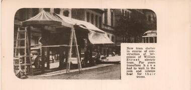
Black and white reproduction photograph of a newspaper item of the construction of the new William Street shelter at the terminus at Collins Street. undated. Has a W Class tram in the background. Rod Atkins advised by email 25/6/2019; Planning was knocked back in 1927 by the MCC - The Age 10/08/1927 page 16 - Trove But is in the Tram Shelter book C1930? in our collection. Pages 17 and 18! Article in TROVE The Argus 2/3/1933 Page 6. Port Melbourne council requesting MMTB to erect a shelter in Market Street at Collins Street.trams, tramways, william st, shelters, mmtb -
 Melbourne Tram Museum
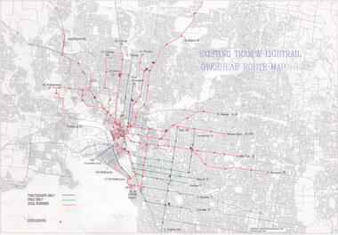
Drawing, Public Transport Corporation (PTC), "Existing tram & Light rail overhead route map", 1996
... Drawings shows on a street plan of Melbourne, tram routes... Drawings shows on a street plan of Melbourne, tram routes, route ...Drawings shows on a street plan of Melbourne, tram routes, route numbers location of cross overs, and track availability of pantograph only, pole only and dual running. Dated 5/6/1996Demonstrates a PTC document for detailing overhead availability and cross overs.Drawing - Document - folded A3 sheettramways, ptc, pantographs, trolley poles, overhead, cross overs, route numbers, tram routes -
 Melbourne Tram Museum
Pamphlet, Public Transport Victoria (PTV), "Route 96 Project - Have your say: Nicholson Street Early Designs", 2013
Set of two pamphlets involved the concept of the "Route 96 Project - Have your say: Nicholson Street Early Designs". Notes the introduction of the E class tram. .1 - DL full colour booklet, 24 pages with a questionnaire response form, outlining the Route 96 project to speed up trams providing route segregation for most of the distance. Issued 2013. Provides concept designs, Blyth St terminus, easy access stops, tram lanes. Gives dates for meetings. .2 - fold out full colour map, 8 folds, printed both sides providing details of the planning for the various stops and segregation between Victoria Parade and Blyth St.. The loss of car parking and issues with the Fitzroy St St Kilda stop met a lot of opposition. The Blyth St terminus was rebuilt June 1015. Two copies held., both were originally contained within a plastic wrapper. One wrapped version obtained when collected. Produced by Public Transport Victoria. See also Reg Item 24?? for a 2009 version.trams, tramways, yarra trams, route 96, east brunswick, e class, superstops -
 Melbourne Tram Museum
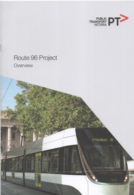
Document - Report, Public Transport Corporation (PTC), "Route 96 Project Overview", 2012
Report 12 A4 pages, including card covers, centre stapled, full colour printed on off white paper, titled "Route 96 Project Overview". Looks at the route itself, project objectives, governance arrangements, communications and consultations. Includes a note that the Government has order 50 new trams. Notes the proposed works packages and who would be managing them - VicRoads, Yarra Trams or PTV. Includes photos of Bourke St, street plans and information numbers. Has the State Government, VicRoads and Yarra Trams logos. Published 2012.trams, tramways, ptv, route 96, east brunswick, yarra trams -
 Melbourne Tram Museum
Document, A V McLean et al, "Conversion of Convential railway to light rail", 1982
Report prepared by A V McLean Corporate Planning Manager The Met and P A Don Group Manager V/Line about a 1982 study about the replacing the two heavy rail services to St Kilda and Port Melbourne with Light Rail. The paper looks at the financial, economic, accessibility and patronage implications of the conversion. Has maps, tables and recommendations, including routing via Collins and Bourke Streets. Yields information about the conversion of the St Kilda and Port Melbourne rail lines to light rail which opened to St Kilda in Nov. 1987.Paper or report, photocopied 16 A4 pages stapled in the top left hand corner.tramways, light rail, conversion, st kilda, port melbourne, railways, light rail conversion -
 Melbourne Tram Museum
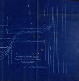
Drawing - PMTT, "Sketch shewing Location of track in Coldblo Street", 12/1908
The drawing shows a 3 road depot layout, with an access track from Glenferrie Road, referring to a letter and a point D on the drawing. Drawing dated 18-12-1908 is some 18 months before the PMTT opened with a 6 road depot and is possibly related to land acquisition. Yields information about PMTT depot planning in 1908.Blueprint of a drawing showing the track layout for the entry to Malvern Tram depot.tramcars, pmtt, malvern depot, trackwork -
 Melbourne Tram Museum
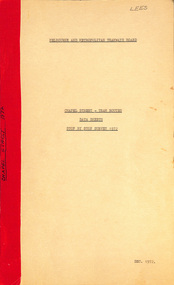
Document - Report, Melbourne & Metropolitan Tramways Board (MMTB), "Chapel Street - Tram Routes - Data Sheets - Stop by Stop survey 1972", Dec. 1972
Report - Foolscap, card covers, red tape binding, 10 pages, titled "Chapel Street - Tram Routes - Data Sheets - Stop by Stop survey 1972" Maps running times and summary including a check across conductors journals. Dated Dec 1972, notes work done by L Hogan, W. TootellHas "Lees" in the top right hand corner and the title on the left side of the report.trams, tramways, routes, passengers, planning, development, chapel st -
 Old Gippstown
Building - Loren Iron House
'Loren' (formerly James Hogg's house) is a two-storey gabled prefabricated house, constructed using broad-gauge corrugated iron and was originally erected at 60-62 Curzon Street, North Melbourne in 1853 for builder, James Hogg. By 1968 the building had deteriorated and it was dismantled and moved to Old Gippstown where it was re-erected and restored. The building's external framing system consists of exposed metal columns with Gothic panel motifs at the corners. Internally the timber framed walls have been finished with new papers over new Hessian. The corrugated iron roof has an unusual concave form and the windows, floors and doors are of moulded softwood. State historic significance as a rare type of iron prefab. house. Listed on the Victorian Heritage Register and covered by a Heritage Overlay, Latrobe City Planning Scheme. It is also listed on the Register of the National Estate.Tall square-shaped two-storey corrugated iron building with a curved corrugated iron roof with two outside brick chimneys. prefabricated iron houses, old gippstown, west gippsland, gippsland, gippsland heritage park, goldfields, coal mine, victorian era, moe, historical village, city of melbourne, north melbourne, curzon street, james hogg, prefabricated house, two-storey gabled prefabricated house, old gippstown heritage park, latrobe valley, loren, latrobe city council -
 Melbourne Tram Museum
Document - Notice, The Met, "North/South LRT route - Port Melbourne Opening", 11/12/1987
Set of Notices to crews associated with the opening of the Port Melbourne Light Rail Line, following its conversion from a Heavy rail line. Signed by Dennis Griffiths, Manager Tram Operations - Western. C5043 - gives details of the route, tram stops, route numbers, traffic signals and T lights, running times, toilet facilites, time clocks and track telephones. Dated 16/12/1987 C5044 - details the new types of automatic points at Flinders and Spencer Sts and Clarendon and Whiteman streets - their operation, associated signals and a layout plan. Dated 22/12/1987 C5046 - Installation of automatic points - Whiteman St Y Junction - later known as Port Junction - St Kilda - Port Melbourne lines - dated 22/12/1987 Interoffice memo to Conductors - Preston and North Fitzroy depot routes - regarding section points on the Port Melbourne and St Kilda light rail routes. Dated 25/6/1987 - signed by Ray Stock, Manger Revenue Systems.Yields information about the opening of the Port Melbourne line in 1987.Set of 7 A4 sheets stapled in top left hand corner.tramcars, tramways, port melbourne, opening, new tramway, points, operations, fares, signals -
 Melbourne Tram Museum
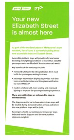
Pamphlet, Yarra Trams, "Your new Elizabeth Street is almost here", Oct. 2013
Pamphlet, DL size, green and white advising about the new Elizabeth St streets stops being opened in mid November 2013. Gives details of the stops, the benefits, a plan showing existing stops, new platform stops and temporary stops. Has the Yarra Trams and PTV logos. .1 - pamphlet or hanging notices to around tram handrails, cut out advised of the changes to services due to tramway or other works for changes to routes 19. 57. 59. 86 and 96 5/10/13 to 9/10/13. Item .1 added 8/1/2019.trams, tramways, yarra trams, elizabeth st, tram stops, platform stops, route 19, route 57, route 59, route 86, route 96 -
 Melbourne Tram Museum
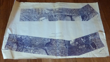
Drawing, Melbourne & Metropolitan Tramways Board (MMTB), Aerial photographs Bundoora Tram Extensions, Plenty Road – MMTB Drawings – 12/1979, Bundoora Extension – Metropolitan Transit Authority – 2/1983, John-Connell – Mott Hay and Anderson – Preliminary drawings for the Latrobe Modal Interchange – August 1984, 1979 to 1984
Set of drawings for the MMTB Plenty Road extension in 1979, MTA extension to Bundoora in 1983 and the Latrobe Uni Modal Interchange - 1984. Large print – Aerial photographs Bundoora Tram Extensions Stage 2 – Albert St to Kingsbury Drive Stage 3 – Kingsbury Drive to Settlement Road Has been rolled, left hand edge damaged, right hand edge torn Compiled by the ROW Division – 2/1981. Has written on rear at right hand end “Bundoora Tram Extension – Official MMTB Plans” 760H x 1190W Plenty Road – MMTB Drawings – 12/1979 P15123 Tyler St to Walsal Avenue P15124 Walsal Ave t McColl St P15125 McColl St to Dorrington Avenue Bundoora Extension – Metropolitan Transit Authority – 2/1983 P15400 Dorrington Avenue to Barwon Avenue P15401 Barwon Avenue to Nicholson Ave P15402 Nicholson St to Barling Park P15403 Barling Park to Darebin Creek P15404 Darebin Creek to Scott Grove P15405 Scott Grove to Clunes Street P15406 Clunes St to Cash St P15408 Cash St to Bundoora Park P15409 Bundoora Park to Larundel Hospital P15410 At Larundel Hospital P15411 Larundel Hospital to Marne Court P15412 Marne Court to Cherrywood Court P15413 Cherrywood Court to Morwell Ave P15414 Morwell Ave to Grimshaw St P15415 Grimshaw St to Nickson Street P15416 Nickson St to McLeans Road John-Connell – Mott Hay and Anderson – Preliminary drawings for the Latrobe Modal Interchange – August 1984. 8094-A-20 Set Out Plan and Paving Details 8094-A-21 Elevations 8094-A-22 Sections 8094-A-23 Roof Plan and Stormwater Layout 8094-A-24 Canopy Details 8094-A-25 Toilet Block and Waiting Room 8094-A-28 Miscellaneous DetailsOn rear of aerial photograph sheet - at right hand end “Bundoora Tram Extension – Official MMTB Plans” in felt pen.trams, tramways, plenty rd, bundoora, latrobe university, mmtb, construction, mta -
 Bacchus Marsh & District Historical Society
Map, Maddingley Township, Parish of Parwan, County of Grant, 1856
Maddingley is a locality or township within the broader township area of Bacchus Marsh. This map is dated 1856 but is based on an earlier survey in 1843. The main area of Maddingley shown on this map is an area bounded by Bacchus Street, Moore Street, Griffith Street and Franklin Street. Other streets visible are Inglis Street, Labilliere Street, McCrae Street. The area to the east of Franklin Street is not sub-divided and is described as an 'alluvial flat. A single page paper map showing land allotments, streets, and natural watercourses in the township of Maddingley. The map is pasted into a bound volume containing 76 maps or plans in total. Two inscriptions: 1. A.J. Skene Surveyor, 1843. ; 2. Surveyor-General's Office Melbourne, Sept 6, 1856. (Lithographed by R. Meikle)bacchus marsh victoria maps, maddingley victoria maps, land use, maddingley victoria history -
![Map, Ballarat and Gordons Lane Plan of Land required [for railway line work]](/media/collectors/5e461d8021ea67224c82f2a1/items/676ff3a62c3783fe00b96a8d/item-media/676ff4a42c3783fe00b96cb6/item-fit-380x285.jpg) Bacchus Marsh & District Historical Society
Bacchus Marsh & District Historical SocietyMap, Ballarat and Gordons Lane Plan of Land required [for railway line work]
The railway line from Melbourne to Bacchus Marsh was completed in February 1887. After this date work continued to extend the line to Ballan. This map indicates a portion of land only a few hundred metres west of the Bacchus Marsh railway station which would have been among the first stages of the line to Ballan to have been constructed. This suggests the date of this map to be in the late 1880s.Single page map showing land required for railway line work near Griffith Street, Bacchus Marsh. Scale 10 chains to 1 inch. Hand-written on the map are the exact distances between Bacchus Marsh and Gordons (Gordon) and between Bacchus Marsh and Melbourne as measured from the corner of Maddingley Road and Station Street. Distances recorded are in miles, chains and links. The land required for the railway works is marked in red ink and runs through an area known as Kennedy's Gully. Part of a set of maps which are pasted into a bound volume containing 76 maps or plans in total. High resolution digital image stored on BMDHS computer network. bacchus marsh victoria history, maddingley victoria history, railway lines -
 Ringwood and District Historical Society
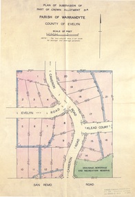
Map - Plans of Subdivision, Part of Crown Allotments 35 & 39, Parish of Warrandyte
Survey maps of stages 1, 2 & 3 of residential allotments in Kalinda Road and Grayling Crescent, Ringwood, Victoria. (Undated, circa 1960). Some allotments are marked with real estate information and prices in pre decimal £s.Adshead & McGuire, Land Surveyors L.S. M.I.S. (Aust), 268 Albert Street East Melbourne (Ref 118/2a b &c) Tel 41-6960. The land colored blue is set apart for drainage & sewerage purposes. Reference Marks (R.M's) are Gal Iron Pipes 12"x1". Levels shown are to M.M.B.W. Datum. The land shown hatched is subject to innundation. -
 Bacchus Marsh & District Historical Society
Map, Plan of the property of Messers Atkins and Clarke to be sold at the Mansion, Bacchus Marsh 19th April 1856. Copy 1
This plan of land allotments for sale indicates the property once owned by the Bacchus family in and around the township area of Bacchus Marsh. The Bacchus family sold their property in Bacchus Marsh to John Atkins and Robert Nalder Clarke in March 1851. Atkins and Clarke kept the property for a number of years until April 1856 when these allotments were put up for sale.This plan is almost identical to another copy held by the Bacchus Marsh and District Historical Society, VC Record 452, BMDHS collection). This plan, VC Record 707 Copy 1, contains a little more detail overall than VC Record 452 Copy 2, such as who did the survey work for the plan (R.C. Bagot) and who the selling agents were, (W.M. Tennent), and on the right side of the plan near the Lerderderg River is indicated the general area for a second parcel of land from this sale which is to be sold. There is also a compass illustration indicating north and south compass points.This is a very early land sales plan for the township of Bacchus Marsh and it therefore provides some clues as to how the early urban development of the township took place. Upon seeing the map in 1911 Bacchus Marsh Express newspaper editor Christopher Crisp wrote "The sale appears to have created the present township, which had a nucleus in earlier times further east", Express, 30 September, 1911, page 3.A single page paper plan showing allotments of land for sale. The subdivided land shown was owned by John Atkins and Robert Nalder Clarke, but previously owned by the Bacchus Family and was in and around their Manor House (Mansion) property in Bacchus Marsh.There are 5 portions of land further divided into numerous small portions. The land for sale is bounded by the present day streets of Main Street, Young Street, McFarland Street, Morton Streets, Crook Street, and part of the eastern section extends to the Lerderderg River. Scale: 8 chains to 1 inch The plan is pasted into a bound volume containing 76 maps or plans in total. BMDHS Loc: AR/B12/S4 Bacchus Marsh Township and Nearby Districts Maps Volume In-house Digital copies: BMDHS, Computer Network: Maps\Bacchus Marsh Township and Nearby Districts Maps VolumeHeading: Plan of the first portion of land. The property of Messers Atkins and Clarke situate at Bacchus Marsh. To be sold by W.M. Tennent & Co. at the Mansion on the Ground on Saturday the 19th April 1856. Below heading: Jas Ferguson, Lithographer On upper right side: Subdivided by R.C. Bagot London and Liverpool Chambers, Melbourne. 'Thos Taubman'. Post Office Stamp: BACCHUS MARSH VICTORIA MY 6, 63bacchus marsh victoria maps, bacchus family, land sales, manor house bacchus marsh -
 Ringwood and District Historical Society
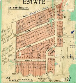
Map, Subdivision Plan, Loughnans Road, Ringwood - circa 1922
Green card with cut-out map of residential allotments, some marked "sold". "Plan of Estate" includes Wonga Road, Loughnans Road, William Street, Andrew Street, Harrison Street, and Munro Street, Ringwood. (Surrounding area is part of Ringwood Park Estate featured in seperate 1922 auction flyer).Handwritten notations - (northern section) {£2-10/- per foot. £5 deposit bal £1 per month} All the rest £2 per foot, value same as above. Licensed Surveyors - W.J. & A.W. Kenhardt, 352 Collins Street, Melbourne. -
 Ringwood and District Historical Society
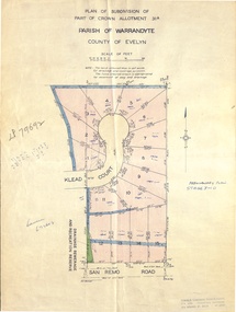
Document - Real Estate Folder, Savernake Estate, Ringwood, Victoria - Stage two - circa 1967
... . Ltd., Consulting Engineers, 472 Bourke Street Melbourne - 67 ...Plan of Subdivision PS79692, Part of Crown Allotment 31A Parish of Warrandyte, and advertisement for sale of residential allotments with map showing layout of Stage 2 of subdivision. Typewritten details for first and second release of Lots 10 to 16 with Terms of sale, stapled to two advertising flyers featuring map of estate showing Lots 1 to 20 on Evelyn Road, Cameron Road, Klead Court, and San Remo Road. Green slip included dated 6 July 1979 showing description of property at Lot 14 (no.4) San Remo Road, vendor - Judith Margaret Love and Lindsale Stephen Love, Cherry Tree Downs, Tarwin Lower 3456. Phone 056635390 Bus 056787203.Agent - C.E. Carter & Son, R.E.S.I. 126 Whitehorse Road, Ringwood. Telephones: 8706024, 8706830, 8702519, A.H.: 7233298, 8782648. Subdivision Plan stamped Donald Cameron Consultants Pty. Ltd., Consulting Engineers, 472 Bourke Street Melbourne - 67-2602. -
 Ringwood and District Historical Society
Document - Real Estate Folder, Savernake Estate, Ringwood, Victoria - Stage one - 1967
... Pty. Ltd., Consulting Engineers, 472 Bourke Street Melbourne ...Plan of Subdivision, Part of Crown Allotment 31A and advertisement for sale of residential allotments with map showing layout of subdivision. Typewritten pricelist attached outlining suggested terms of sale as of 14 September, 1967.Subdivision includes Evelyn Road, Cameron Road, Klead Court, and San Remo Road. Agent - C.E. Carter & Son., 126 Whitehorse Road, Ringwood. (Phone) 87-6024, 87-6830, 870-2519, After hours: 723 3298, 878 2648. Subdivision Plan stamped Donald Cameron Consultants Pty. Ltd., Consulting Engineers, 472 Bourke Street Melbourne - 67-2602. -
 Bacchus Marsh & District Historical Society
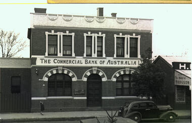
Photograph, Commercial Bank of Australia Main Street Bacchus Marsh
The Commercial Bank of Australia building was constructed by J. F. Taylor in 1907 and shortly after commenced operations as a bank. The building was in use as a CBA bank until 1976 when it was demolished and a new building erected. The CBA continued its operations at this location; subsequently, various banks, such as the Bank of Melbourne and Westpac operated there. Part of the new building is now in use as a newsagency. The original architectural plans for this building designed by Walter Butler are held by the State Library of Victoria and can be viewed online through the Library's website: Citation: Butler, W. R., & Taylor, J. F. (1906). Design for banking premises at Bacchus Marsh for the Commercial Bank of Australia Ltd. URL: http://handle.slv.vic.gov.au/10381/473561 Black and white photographic print. Photograph of the Commercial Bank 138 Main Street Bacchus Marsh. On the left is a smaller brick building adjoining the bank. On the right there is a partial shot of a shop called The House of Hodgson. The bank building itself is shown as a substantial two-story brick building, the top storey appearing to be a dwelling with three ornamented windows furnished with curtains and blinds. The storeys are divided by a white panel bearing the words "The Commercial Bank of Australia Ltd". The lower storey has a central entrance with a panelled door. The door is flanked by two windows with reinforced lattices. The windows and door are surmounted by decorative arches reminiscent of Spanish Moorish architecture. A car (possibly a 1937 Dodge) is parked on the street. A lone girl stands on the footpath waving at the photographer.On the back: In pencil: 1937 Dodge?shops bacchus marsh vic., main street bacchus marsh vic., banks bacchus marsh vic., commercial bank of australia bacchus marsh -
 Melbourne Tram Museum
Drawing - Digtial image, Melbourne & Metropolitan Tramways Board (MMTB), "Plan and Longitudinal sections of Howard Street Siding", 2/1925
Digital image of a drawing for the access tracks to the Howard St car house or cable tram depot from Victoria St. Shows the plan and longitudinal sections. Prepared 23/2/1925 and signed by Mr Strickland Chief Engineer on 25/2/1925. This depot was made necessary by the construction of electric tram tracks in Flemington Road in 1925 which resulted in the closure of the Flemington Road car house near Racecourse Road North Melbourne.Yields information about the access track from Victoria St to the Howard St car house. Digital image of drawing P1613, "Plan and Longitudinal sections of Howard Street Siding".m&mtb, drawings, howard st, cable trams, car houses, depots -
 Port Melbourne Historical & Preservation Society
Document - Application for Planning Permit Rex Hotel, City of Port Phillip, 15 Oct 1996
Two A4 sheets of white paper giving details of the Notice of Application for Planning Permit for the Rex Hotel, 145 Bay Street, Port Melbourne. The application by Lex Carter Pty Ltd was for the use and development of the land for the purpose 'of a place of assembly(club)". The conditions of license are set out on the 2nd page. Rex Hotel 70 pokies Liquor License 9am - 1am Pencil sketch of layout of cnr Bay & Graham Streets.business and traders - hotels, rex hotel, city of port phillip -
 Flagstaff Hill Maritime Museum and Village
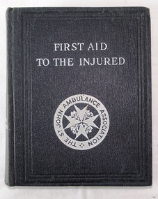
Book - Medical Textbook, First Aid to the Injured, 1939
This book titled First Aid to the Injured was the personal property of Dr. William Roy Angus. It was donated to Flagstaff Hill Maritime Village by the family of Doctor William Roy Angus, Surgeon and Oculist. It is part of the “W.R. Angus Collection” that includes historical medical equipment, surgical instruments and material once belonging to Dr Edward Ryan and Dr Thomas Francis Ryan, (both of Nhill, Victoria) as well as Dr Angus’ own belongings. The Collection’s history spans the medical practices of the two Doctors Ryan, from 1885-1926 plus that of Dr Angus, up until 1969. ABOUT THE “W.R.ANGUS COLLECTION” Doctor William Roy Angus M.B., B.S., Adel., 1923, F.R.C.S. Edin.,1928 (also known as Dr Roy Angus) was born in Murrumbeena, Victoria in 1901 and lived until 1970. He qualified as a doctor in 1923 at University of Adelaide, was Resident Medical Officer at the Royal Adelaide Hospital in 1924 and for a period was house surgeon to Sir (then Mr.) Henry Simpson Newland. Dr Angus was briefly an Assistant to Dr Riddell of Kapunda, then commenced private practice at Curramulka, Yorke Peninsula, SA, where he was physician, surgeon and chemist. In 1926, he was appointed as new Medical Assistant to Dr Thomas Francis Ryan (T.F. Ryan, or Tom), in Nhill, Victoria, where his experiences included radiology and pharmacy. In 1927 he was Acting House Surgeon in Dr Tom Ryan’s absence. Dr Angus had become engaged to Gladys Forsyth and they decided he further his studies overseas in the UK in 1927. He studied at London University College Hospital and at Edinburgh Royal Infirmary and in 1928, was awarded FRCS (Fellow from the Royal College of Surgeons), Edinburgh. He worked his passage back to Australia as a Ship’s Surgeon on the on the Australian Commonwealth Line’s T.S.S. Largs Bay. Dr Angus married Gladys in 1929, in Ballarat. (They went on to have one son (Graham 1932, born in SA) and two daughters (Helen (died 12/07/1996) and Berenice (Berry), both born at Mira, Nhill According to Berry, her mother Gladys made a lot of their clothes. She was very talented and did some lovely embroidery including lingerie for her trousseau and beautifully handmade baby clothes. Dr Angus was a ‘flying doctor’ for the A.I.M. (Australian Inland Ministry) Aerial Medical Service in 1928. Its first station was in the remote town of Oodnadatta, where Dr Angus was stationed. He was locum tenens there on North-South Railway at 21 Mile Camp. He took up this ‘flying doctor’ position in response to a call from Dr John Flynn; the organisation was later known as the Flying Doctor Service, then the Royal Flying Doctor Service. A lot of his work during this time involved dental surgery also. Between 1928-1932 he was surgeon at the Curramulka Hospital, Yorke Peninsula, South Australia. In 1933 Dr Angus returned to Nhill and purchased a share of the Nelson Street practice and Mira hospital (a 2 bed ward at the Nelson Street Practice) from Dr Les Middleton one of the Middleton Brothers, the current owners of what previously once Dr Tom Ryan’s practice. Dr Tom and his brother had worked as surgeons included eye surgery. Dr Tom Ryan performed many of his operations in the Mira private hospital on his premises. He had been House Surgeon at the Nhill Hospital 1902-1926. Dr Tom Ryan had one of the only two pieces of radiology equipment in Victoria during his practicing years – The Royal Melbourne Hospital had the other one. Over the years Dr Tom Ryan had gradually set up what was effectively a training school for country general-practitioner-surgeons. Each patient was carefully examined, including using the X-ray machine, and any surgery was discussed and planned with Dr Ryan’s assistants several days in advance. Dr Angus gained experience in using the X-ray machine there during his time as assistant to Dr Ryan. When Dr Angus bought into the Nelson Street premises in Nhill he was also appointed as the Nhill Hospital’s Honorary House Surgeon 1933-1938. His practitioner’s plate from his Nhill surgery is now mounted on the doorway to the Port Medical Office at Flagstaff Hill Maritime Village, Warrnambool. When Dr Angus took up practice in the Dr Edward and Dr Tom Ryan’s old premises he obtained their extensive collection of historical medical equipment and materials spanning 1884-1926. A large part of this collection is now on display at the Port Medical Office at Flagstaff Hill Maritime Village in Warrnambool. In 1939 Dr Angus and his family moved to Warrnambool where he purchased “Birchwood,” the 1852 home and medical practice of Dr John Hunter Henderson, at 214 Koroit Street. (This property was sold in1965 to the State Government and is now the site of the Warrnambool Police Station and an ALDI sore is on the land that was once their tennis court). The Angus family was able to afford gardeners, cooks and maids; their home was a popular place for visiting dignitaries to stay whilst visiting Warrnambool. Dr Angus had his own silk worm farm at home in a Mulberry tree. His young daughter used his centrifuge for spinning the silk. Dr Angus was appointed on a part-time basis as Port Medical Officer (Health Officer) in Warrnambool and held this position until the 1940’s when the government no longer required the service of a Port Medical Officer in Warrnambool; he was thus Warrnambool’s last serving Port Medical Officer. (Masters of immigrant ships arriving in port reported incidents of diseases, illness and death and the Port Medical Officer made a decision on whether the ship required Quarantine and for how long, in this way preventing contagious illness from spreading from new immigrants to the residents already in the colony.) Dr Angus was a member of the Australian Medical Association, for 35 years and surgeon at the Warrnambool Base Hospital 1939-1942, He served with the Australian Department of Defence as a Surgeon Captain during WWII 1942-45, in Ballarat, Victoria, and in Bonegilla, N.S.W., completing his service just before the end of the war due to suffering from a heart attack. During his convalescence he carved an intricate and ‘most artistic’ chess set from the material that dentures were made from. He then studied ophthalmology at the Royal Melbourne Eye and Ear Hospital and created cosmetically superior artificial eyes by pioneering using the intrascleral cartilage. Angus received accolades from the Ophthalmological Society of Australasia for this work. He returned to Warrnambool to commence practice as an ophthalmologist, pioneering in artificial eye improvements. He was Honorary Consultant Ophthalmologist to Warrnambool Base Hospital for 31 years. He made monthly visits to Portland as a visiting surgeon, to perform eye surgery. He represented the Victorian South-West subdivision of the Australian Medical Association as its secretary between 1949 and 1956 and as chairman from 1956 to 1958. In 1968 Dr Angus was elected member of Spain’s Barraquer Institute of Barcelona after his research work in Intrasclearal cartilage grafting, becoming one of the few Australian ophthalmologists to receive this honour, and in the following year presented his final paper on Living Intrasclearal Cartilage Implants at the Inaugural Meeting of the Australian College of Ophthalmologists in Melbourne In his personal life Dr Angus was a Presbyterian and treated Sunday as a Sabbath, a day of rest. He would visit 3 or 4 country patients on a Sunday, taking his children along ‘for the ride’ and to visit with him. Sunday evenings he would play the pianola and sing Scottish songs to his family. One of Dr Angus’ patients was Margaret MacKenzie, author of a book on local shipwrecks that she’d seen as an eye witness from the late 1880’s in Peterborough, Victoria. In the early 1950’s Dr Angus, painted a picture of a shipwreck for the cover jacket of Margaret’s book, Shipwrecks and More Shipwrecks. She was blind in later life and her daughter wrote the actual book for her. Dr Angus and his wife Gladys were very involved in Warrnambool’s society with a strong interest in civic affairs. He had an interest in people and the community. They were both involved in the creation of Flagstaff Hill, including the layout of the gardens. After his death (28th March 1970) his family requested his practitioner’s plate, medical instruments and some personal belongings be displayed in the Port Medical Office surgery at Flagstaff Hill Maritime Village, and be called the “W. R. Angus Collection”. The First Aid textbook is significant as an example of first aid treatment in the early to mid 20th century. The W.R. Angus Collection is significant for still being located at the site it is connected with, Doctor Angus being the last Port Medical Officer in Warrnambool. The collection of medical instruments and other equipment is culturally significant, being an historical example of medicine, administration, household equipment and clothing from late 19th to mid-20th century. Dr Angus assisted Dr Tom Ryan, a pioneer in the use of X-rays and in ocular surgery. Handbook, First Aid, "First Aid to the Injured", part of the W.R. Angus Collection. Book was written and published by The Authorised textbook of the St. John Ambulance Association, 1939 - 39th Edition, 8th impression. Diagram attached inside front cover shows bones and arteries. Textbook includes illustrations, diagrams and photos. Inscribed in black ink "W.R. Angus / Warrnambool / Victoria / 1939" Inscribed in black ink "W.R. Angus / Warrnambool / Victoria / 1939" Handwritten “ANGUS” in capital letters on foot edge of text block. flagstaff hill, warrnambool, shipwrecked coast, flagstaff hill maritime museum, maritime museum, shipwreck coast, flagstaff hill maritime village, great ocean road, dr w r angus, dr ryan, t.s.s. largs bay, warrnambool base hospital, nhill base hospital, mira hospital, flying doctor, department of defence australia, australian army, army, medical treatment, medical history, medical education, st john first aid, book, st john ambulance association, medical textbook, first aid textbook -
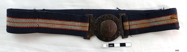 Flagstaff Hill Maritime Museum and Village
Clothing - Belt, late 1920's
This late 1920’s elastic belt is decorated with an anchor, giving it a nautical theme. It was worn by Dr W.R. Angus during his service as ship’s surgeon on ships "BANESHIRE" and the Australian Commonwealth Line’s T.S.S. “LARGS BAY”, when he worked his passage to the UK and return to Australia for his overseas studies. He was awarded the FRCS (Fellow from the Royal College of Surgeons) in 1928 in Edinburgh, Scotland. The belt was donated to Flagstaff Hill Maritime Village, along with photos of the ship LARGS BAY and of Dr Angus in his ship surgeon’s uniform, by the family of Doctor William Roy Angus, Surgeon and Oculist. ABOUT THE “W.R.ANGUS COLLECTION” Doctor William Roy Angus M.B., B.S., Adel., 1923, F.R.C.S. Edin.,1928 (also known as Dr Roy Angus) was born in Murrumbeena, Victoria in 1901 and lived until 1970. He qualified as a doctor in 1923 at University of Adelaide, was Resident Medical Officer at the Royal Adelaide Hospital in 1924 and for a period was house surgeon to Sir (then Mr.) Henry Simpson Newland. Dr Angus was briefly an Assistant to Dr Riddell of Kapunda, then commenced private practice at Curramulka, Yorke Peninsula, SA, where he was physician, surgeon and chemist. In 1926, he was appointed as new Medical Assistant to Dr Thomas Francis Ryan (T.F. Ryan, or Tom), in Nhill, Victoria, where his experiences included radiology and pharmacy. In 1927 he was Acting House Surgeon in Dr Tom Ryan’s absence. Dr Angus had become engaged to Gladys Forsyth and they decided he further his studies overseas in the UK in 1927. He studied at London University College Hospital and at Edinburgh Royal Infirmary and in 1928, was awarded FRCS (Fellow from the Royal College of Surgeons), Edinburgh. He worked his passage back to Australia as a Ship’s Surgeon on the on the Australian Commonwealth Line’s T.S.S. Largs Bay. Dr Angus married Gladys in 1929, in Ballarat. (They went on to have one son (Graham 1932, born in SA) and two daughters (Helen (died 12/07/1996) and Berenice (Berry), both born at Mira, Nhill ) According to Berry, her mother Gladys made a lot of their clothes. She was very talented and did some lovely embroidery including lingerie for her trousseau and beautifully handmade baby clothes. Dr Angus was a ‘flying doctor’ for the A.I.M. (Australian Inland Ministry) Aerial Medical Service in 1928 . Its first station was in the remote town of Oodnadatta, where Dr Angus was stationed. He was locum tenens there on North-South Railway at 21 Mile Camp. He took up this ‘flying doctor’ position in response to a call from Dr John Flynn; the organisation was later known as the Flying Doctor Service, then the Royal Flying Doctor Service. A lot of his work during this time involved dental surgery also. Between 1928-1932 he was surgeon at the Curramulka Hospital, Yorke Peninsula, South Australia. In 1933 Dr Angus returned to Nhill and purchased a share of the Nelson Street practice and Mira hospital (a 2 bed ward at the Nelson Street Practice) from Dr Les Middleton one of the Middleton Brothers, the current owners of what previously once Dr Tom Ryan’s practice. Dr Tom and his brother had worked as surgeons included eye surgery. Dr Tom Ryan performed many of his operations in the Mira private hospital on his premises. He had been House Surgeon at the Nhill Hospital 1902-1926. Dr Tom Ryan had one of the only two pieces of radiology equipment in Victoria during his practicing years – The Royal Melbourne Hospital had the other one. Over the years Dr Tom Ryan had gradually set up what was effectively a training school for country general-practitioner-surgeons. Each patient was carefully examined, including using the X-ray machine, and any surgery was discussed and planned with Dr Ryan’s assistants several days in advance. Dr Angus gained experience in using the X-ray machine there during his time as assistant to Dr Ryan. When Dr Angus bought into the Nelson Street premises in Nhill he was also appointed as the Nhill Hospital’s Honorary House Surgeon 1933-1938. His practitioner’s plate from his Nhill surgery is now mounted on the doorway to the Port Medical Office at Flagstaff Hill Maritime Village, Warrnambool. When Dr Angus took up practice in the Dr Edward and Dr Tom Ryan’s old premises he obtained their extensive collection of historical medical equipment and materials spanning 1884-1926. A large part of this collection is now on display at the Port Medical Office at Flagstaff Hill Maritime Village in Warrnambool. In 1939 Dr Angus and his family moved to Warrnambool where he purchased “Birchwood,” the 1852 home and medical practice of Dr John Hunter Henderson, at 214 Koroit Street. (This property was sold in1965 to the State Government and is now the site of the Warrnambool Police Station. and an ALDI store is on the land that was once their tennis court). The Angus family was able to afford gardeners, cooks and maids; their home was a popular place for visiting dignitaries to stay whilst visiting Warrnambool. Dr Angus had his own silk worm farm at home in a Mulberry tree. His young daughter used his centrifuge for spinning the silk. Dr Angus was appointed on a part-time basis as Port Medical Officer (Health Officer) in Warrnambool and held this position until the 1940’s when the government no longer required the service of a Port Medical Officer in Warrnambool; he was thus Warrnambool’s last serving Port Medical Officer. (Masters of immigrant ships arriving in port reported incidents of diseases, illness and death and the Port Medical Officer made a decision on whether the ship required Quarantine and for how long, in this way preventing contagious illness from spreading from new immigrants to the residents already in the colony.) Dr Angus was a member of the Australian Medical Association, for 35 years and surgeon at the Warrnambool Base Hospital 1939-1942, Dr Angus served with the Australian Department of Defence as a Surgeon Captain during WWII 1942-45, in Ballarat, Victoria, and in Bonegilla, N.S.W., completing his service just before the end of the war due to suffering from a heart attack. During his convalescence he carved an intricate and ‘most artistic’ chess set from the material that dentures were made from. He then studied ophthalmology at the Royal Melbourne Eye and Ear Hospital and created cosmetically superior artificial eyes by pioneering using the intrascleral cartilage. Angus received accolades from the Ophthalmological Society of Australasia for this work. He returned to Warrnambool to commence practice as an ophthalmologist, pioneering in artificial eye improvements. He was Honorary Consultant Ophthalmologist to Warrnambool Base Hospital for 31 years. He made monthly visits to Portland as a visiting surgeon, to perform eye surgery. He represented the Victorian South-West subdivision of the Australian Medical Association as its secretary between 1949 and 1956 and as chairman from 1956 to 1958. In 1968 Dr Angus was elected member of Spain’s Barraquer Institute of Barcelona after his research work in Intrasclearal cartilage grafting, becoming one of the few Australian ophthalmologists to receive this honour, and in the following year presented his final paper on Living Intrasclearal Cartilage Implants at the Inaugural Meeting of the Australian College of Ophthalmologists in Melbourne In his personal life Dr Angus was a Presbyterian and treated Sunday as a Sabbath, a day of rest. He would visit 3 or 4 country patients on a Sunday, taking his children along ‘for the ride’ and to visit with him. Sunday evenings he would play the pianola and sing Scottish songs to his family. One of Dr Angus’ patients was Margaret MacKenzie, author of a book on local shipwrecks that she’d seen as an eye witness from the late 1880’s in Peterborough, Victoria. In the early 1950’s Dr Angus, painted a picture of a shipwreck for the cover jacket of Margaret’s book, Shipwrecks and More Shipwrecks. She was blind in later life and her daughter wrote the actual book for her. Dr Angus and his wife Gladys were very involved in Warrnambool’s society with a strong interest in civic affairs. He had an interest in people and the community They were both involved in the creation of Flagstaff Hill, including the layout of the gardens. After his death (28th March 1970) his family requested his practitioner’s plate, medical instruments and some personal belongings be displayed in the Port Medical Office surgery at Flagstaff Hill Maritime Village, and be called the “W. R. Angus Collection”. This belt is representative of the uniform worn by ship’s staff in the 1920’s. The belt is also representative of Australian medical students travelling overseas to complete their medical studies. The W.R. Angus Collection is significant for still being located at the site it is connected with, Doctor Angus being the last Port Medical Officer in Warrnambool. The collection of medical instruments and other equipment is culturally significant, being an historical example of medicine, administration, household equipment and clothing from late 19th to mid-20th century. Dr Angus assisted Dr Tom Ryan, a pioneer in the use of X-rays and in ocular surgery. Belt, part of the W.R. Angus Collection. Elastic belt, black, grey and red horizontal stripes. Round black-painted metal fastening on each end with remnants of gold zing-zag border around buckle’s wreath end an anchor impressed into the buckle’s tongue. flagstaff hill, warrnambool, shipwrecked coast, flagstaff hill maritime museum, maritime museum, shipwreck coast, flagstaff hill maritime village, great ocean road, dr w r angus, dr ryan, t.s.s. largs bay, warrnambool base hospital, nhill base hospital, mira hospital, flying doctor, ship medical staff uniform, ship medical staff belt, 1920’s elastic belt with tongue and wreath buckle, tongue and wreath belt buckle with anchor symbol, ship staff uniform, 1920’s belt -
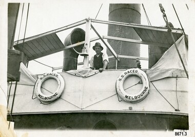 Flagstaff Hill Maritime Museum and Village
Photograph - Vessel, Steam tug "Racer", circa 1920's
The ocean Steamtug "Racer" was built in 1886 in Sunderland by "Boolds, Sharer and Company" for the "Queenstown Tug and Shipping Company". It is mentioned in several newspapers that soon afterwards it sank in Queenstown Harbour, Ireland and remained submerged for six months before being raised. It was a steel screw boat with a sluice keel, was 185 tons and 420 feet long. It was purchased around 1889 by the "Melbourne Coal, Shipping and Engineering Company Ltd" as it had sufficient power to work with the huge iron clippers that the company were dealing with. It survived several dangerous incidents on its voyage out to Melbourne. On May 28th in the middle of the night in a heavy gale, the tug was swamped by heavy seas and then several hours later was almost run down by a very large ship (the clipper Loch Vennachar) in full sail. The "Racer" (later owned by the "Melbourne Steamship Company") became one of the fastest and best-known tugs in the Port of Melbourne - working in the port until 1935. The "Racer" was involved in many rescues and dangerous incidents during its 45 years including the attempted rescue of the "Craigburn" near Cape Schanck, the rescue of the "Edina" from a reef near Williamstown and the rescue of the "Netherby" from heavy seas near Inverloch. In March 1930 she was caught by a strong wind when turning in the Yarra River and crashed into the Spencer Street Bridge - resulting in some damage to the scaffolding on the bridge and slight damage to the tug. In 1906 the "Racer" created a record for the fastest tow when it towed the 900-ton barque "Elizabeth Graham" from Sydney to Melbourne in 73 hours. In 1934 it was withdrawn from commission with plans for it to be broken up for scrap metal but was bought by a Melbourne businessman to be converted into a three masted schooner trading between Tasmania and Melbourne. George (Joe) Cunningham was born in 1892 in Geelong. His father, Alexander Cunningham was a ship builder and carpenter. George worked on oceangoing ships as a young man but after his marriage, had a twenty-six year career on Tugboats. He worked as a deckhand on the "Racer" and then worked his way up as a mate and then master on the "Maitland" and "Tooronga". Later he was in charge of two larger boats - the "Alvina" and "Helen Moore" and was engaged in salvaging the Union Steamship vessel "Karkariki" near Gellibrand Pile Light at the entrance to Hobsons Bay. George Cunningham died in 1978. This photograph was one of ten photographs donated to Flagstaff Hill Maritime Museum and Village by Fred Trewartha. Frederick John Fox Trewartha (Fred) was a well-known Warrnambool businessman. He was born in Beeac near Geelong in 1920 and came to Warrnambool with his family as a very young child. He was apprenticed to his father John, as a saddler and later opened his own shop on Raglan Parade. He then moved into working with tarpaulins and canvases for the trucking industry. Fred was keenly interested in photography (and was a member of the Warrnambool Cine Club), yachting and boat building. He kept his yacht moored at Port Fairy for many years and participated in sailing events locally and interstate. He also built boats with his sons. He had the opportunity to meet many older sailors and it's thought this photo (and others in the set) may have been given to him by one of these men. Fred Trewartha died in 2016 in Warrnambool.This item is significant as a reminder of the important role tugboats and their crews played in the maritime history of Melbourne and the surrounding seas. This is a close-up view of a tugboat showing a man leaning against the upper deck. Two lifebuoys (with the words S. S. Racer Melbourne) are attached to the side of the deck and a funnel and an airvent are in the background. A handwritten note in pencil saying "Geo Cunningham on board Racer "is on the back of the photograph.Back - "Geo Cunningham on board Racer" Front (on lifebuoys) - S. S. RACER MELBOURNEflagstaff hill maritime museum and village, great ocean road, tugboats, steamtug boats, racer, george cunningham, port of melbourne, melbourne steamship company, rescues, craigburn, steamtug, edina, elizabeth graham, netherby, yarra river, ships, historic maritime photographs, boolds sharer and company, queenstown tug and shipping company, melbourne coal shipping and engineering company limited -
Port Melbourne Historical & Preservation Society
Plan, Graeme Bentley Pty Ltd, Port Melbourne Foreshore Landscape Master Plan MP3 (A), February 1993
The Port Melbourne Foreshore Landscape Master Plan was created by Landscape Architectural firm of Graeme Bentley Pty Ltd for the City of Port Melbourne. MP3 (A) portrays the section of foreshore from Dow Street to Pickles Street. The plan proposed street tree planting along Beach Street and development of a park area opposite Johnson Street. The plan was not actioned.built environment - recreational facilities, beach street, port melbourne foreshore -
Port Melbourne Historical & Preservation Society
Plan, Graeme Bentley Pty Ltd, Port Melbourne Foreshore Landscape Master Plan MP4 (B), February 1993
... The Port Melbourne Foreshore Landscape Master Plan... The Port Melbourne Foreshore Landscape Master Plan was created ...The Port Melbourne Foreshore Landscape Master Plan was created by Landscape Architectural firm of Graeme Bentley Pty Ltd for the City of Port Melbourne. MP4 (B) portrays the section of foreshore Surrounding the Port Melbourne Lifesaving Club.The plan proposed street tree planting and lawn areas. The plan was not actioned.built environment - recreational facilities, beach street, port melbourne foreshore, port melbourne life saving club -
Port Melbourne Historical & Preservation Society
Plan, Graeme Bentley Pty Ltd, Port Melbourne Foreshore Landscape Master Plan MP 5 (B), February 1993
The Port Melbourne Foreshore Landscape Master Plan was created by Landscape Architectural firm of Graeme Bentley Pty Ltd for the City of Port Melbourne. MP5 (B) has detailed alterations to the area around the Port Melbourne Yacht Club. The plan was not actioned.built environment - recreational facilities, beach street, port melbourne foreshore, port melbourne yacht club -
Port Melbourne Historical & Preservation Society
Plan, Graeme Bentley Pty Ltd, Port Melbourne Foreshore Landscape Master Plan MP1(A), February 1993
The Port Melbourne Foreshore Landscape Master Plan was created by Landscape Architectural firm of Graeme Bentley Pty Ltd for the City of Port Melbourne. MP1(A) portrays the section of foreshore from the former Port Melbourne Railway Station to Bay Street. The plan proposed extensive tree planting including Tasmanian native trees along Station Pier. The plan was not actioned.built environment - recreational facilities, beach street, port melbourne foreshore, station pier -
Port Melbourne Historical & Preservation Society
Plan, Graeme Bentley Pty Ltd, Port Melbourne Foreshore Landscape Master Plan MP2 (A), February 1993
The Port Melbourne Foreshore Landscape Master Plan was created by Landscape Architectural firm of Graeme Bentley Pty Ltd for the City of Port Melbourne. MP2 (A) portrays the section of foreshore from Stokes Street to Dow Street. The plan proposed street tree planting along Beach Street. The plan was not actioned.built environment - recreational facilities, beach street, port melbourne foreshore, station pier -
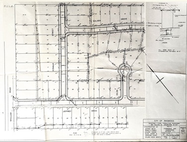 Ringwood and District Historical Society
Document, Plan of Subdivision - Golden Wood Estate, Ringwood, Victoria - 1964
City of Ringwood drawing No.520 dated October 1964, for construction of Jeffrey Drive, Ronald Street, Golden Grove, Gilda Court and Jennifer Court, off Mullum Mullum Road, Ringwood.Consulting Engineers: Geoffrey C. Bird, 483 Collins Street, Melbourne (Tel) 62 1517. Principal: Commerce and Commission Victoria P/L.