Showing 6759 items matching "timor street"
-
 Eltham District Historical Society Inc
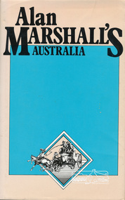
Book, Hyland House, Alan Marshall's Australia, 1981
One of a collection of books by local writer Alan Marshall held at EDHS. This one is of "anecdotes and yarns" as described by Marshall before its publication in July 1981 in the Canberra Times. Alan Marshall's Australia, the Australia of "I Can Jump Puddles" has vanished. No longer do we have time to sit on the sliprail and exchange yarns, to drive buggies down long, quiet dusty roads, or to watch the king-hit merchant operating in some small hotel. Even the Cu-nims hold no terrors for a Boeing 427! And yet - Alan Marshall's Australia lives for all those who read this book. Meet Lance Skuthorpe who tethered an old bull in Bourke Street and offered £5 to anyone who could ride it for half a minute and Binjarrpooma, the Arnhem Land terror. Accompany Alan in his horse-drawn caravan or buggy to country sales, pubs and stations and listen with him to great bush eccentrics, lairs and yarn spinners. Go further back and remember Conversation Lollies, the cigarette cards you collected and the school yard games. Can you recall how to test an axe blade, choose a pocket knife, or the penetrating power of Goanna Oil? But this book is more than a nostalgic journey into the past ; it is history for the young and a timely reminder for us all - it is our roots. - Front end papers viii, 165 p. : ill. ; Two copiesISBN 0908090390alan marshall, prose, short stories, ancedotes, australia, tales, yarms -
 Eltham District Historical Society Inc
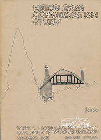
Book, Graem Butler, Heidelberg Conservation Study, Part 1 Heidelberg Historic Buildings and Areas Assessment by Graeme Butler, November 1985
... , landscape areas, mileposts, divided street construction, in a time..., landscape areas, mileposts, divided street construction, in a time ...Historic Buildings and Areas Assessment by Graeme Butler. Part 1 of award winning study carried out in 1982 in collaboration with a community advisory committee to Heidelberg City Council. Pioneering identification of a broad range of heritage assets varying from buildings, gravestones, farm structures, landscape areas, mileposts, divided street construction, in a time when buildings only were assessed in municipal studies.2 v. : ill., maps ; 29 cm.significant buildings heidelberg victoria, history development of heidelberg victoria, man-made landscape heidelberg victoria, significant precincts heidelberg victoria, conservation study, graeme butler -
 Eltham District Historical Society Inc
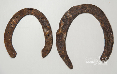
Horseshoe, Two horseshoes, c.1860, 1860s
ELTHAM POLICE QUARTERS & REAR STABLE (FORMER), is listed on the Victorian Heritage Database. The stables are described: "The original single stall brick stables building with loft, built in 1859-60.."These horseshoes were dug up by the owners of the property adjoining the former Eltham Police Station and Court House site behind the stables when working in their garden. Presumably they were discarded adjacent to the stables where the Police horses were kept and over time became covered with soil and other material. They were presented to the Society by the owner during the Local History Centre Open Day held for the Society's 50th anniversary 4 March 2017.Two iron (rusty) horsehoes, one significantly larger than the other; the larger shoe appearing to be not fully manufactured as no nail holeshorseshoe, police residence, police station, brougham street, eltham -
 Eltham District Historical Society Inc
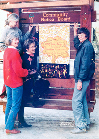
Photograph, Ron Grant, The Eltham Peace Group hanging the Hiroshima Day Banner on the Community Notice Board, Arthur Street, Eltham; Community Arts 1986 'As We Are' Banner Project Group, Hiroshima Day, 6 August 1986
Arthur Street, Eltham next to ANZ Bank The Hiroshima Day Banner was made by Jacky Talbot as part of the project. The women wanted to do something for Hiroshima Day and suggested that a workshop be set aside to make a banner. The artist was concerned about the remaining time scheduled for the project and spent several days "whipping" up the banner herself. For the artist this banner was to prove quite significant. The women hung it at the Community Notice Board on Hiroshima Day and were photographed by the local newspaper publicising the group and drawing wider community attention to the remembrance of the day. Although no new members joined the group from this activity, the artist felt that she was more fully accepted by the group afterwards. This banner has initiated a small group of women committed to peace. The artist has also continued to liaise and meet with the women as time permits. Future group plans include: making kimonos to wear when carrying the banner, participating in the Palm Sunday March, an observance of Hiroshima Day activity, which is yet to be decided, establishing contact with a sister-town in USA and USSR and supporting Eltham Council's stance as a Nuclear Free Zone. (The banner habits of the Eltham tribes : Eltham Shire "as we are" Community Banner Project report / by Jacky Talbot, Shire of Eltham, Feb. 1987, p46) Used in Shire of Eltham display at the Eltham Community Festival, 7 November 1987. Shire of Eltham Engineering Department Providing the resources to undertake • Survey, design, consultation • Road construction and maintenance • Bridge construction and maintenance • Street sweeping • Drain and pit cleaning • Traffic engineering installation and maintenance • Garbage collection • Tip management, land reclamation and beautification • Maintenance of community buildings • Provision of community and recreation facilitiesIllustrative of services provided by former Shire of ElthamColour photograph 20 x 29 cm mounted on green-painted chipboard 28 x 35.5 cm (string on back for hanging) Ref: 01842-0Title printed on label adhered to board below photograph (replaced June 2017)display panel, eltham festival, eltham peace banner, hiroshima day banner, infrastructure, shire of eltham, laurel eckersall, anne laurence, betty johnson, joan maclagan -
 Eltham District Historical Society Inc
Photograph, Eltham Festival Parade, 16 October 1982, 1982
Roll of negatives of the Eltham Festival Parade as it progresses along Main Road past the Catholic Church heading towards Bridge Street. Floats included the Tasmanian Wilderness Society with the Save the Franklin River campaign, and Diamond Valley Railway celebrating 21 years of passenger service as well as the Victorian Police Marching Band. A well known Eltham identity, Jock Read was asked to lead the Eltham Pony Club contingent that year and the roll includes several shots of Jock on his horse, Lofty who was approximately ten years of age, his colour was still classed as a steel grey at the time before he went "white" quite a few years later. 1982: 16-17 October. “Pioneers of Eltham” and tractor (rain) Neswletter No. 27, November 1982 Although our parade entry did not win a prize this year, it was considered highly successful from a participation point of view. Despite some uncertainty as to just who was coming, members and friends kept appearing at the assembly area. As in the past years our friends from the Victorian Folk Music Club brought their instruments along and really added to the occasion. This year we concentrated on a rural theme with a tractor/trailer combination. Thanks to Peter Bassett-Smith for the tractor, Joh Ebeli for the decorations and friendly trailer owner Dennis McKay. Unfortunately the closing stages of the parade were marred by heavy rain. We just finished as the rain started but members scattered very quickly. This has prompted the suggestion for future parades that we have a tent or other suitable venue for members to gather after the event. This is worth following up. The cold driving rain provided a special problem for Peter in driving his tractor home to Kangaroo Ground. Have you ever had to choose between standing up to warm your hands on the exhaust and having your tractor seat flooded? Certificate, Festival Parade Award, Rotary Club of Eltham, Eighth Eltham Community Festival 1982. Presented to the Shire of Eltham Historical Society for the most effort by "locals"Roll of 35mm colour negative film, 24 shotsKodak Safety Film 5035eltham festival, catholic church, diamond valley railway, eltham, eltham district historical society, eltham parade, festivals, eltham fire brigade, eltham horse and pony club, jock read, learning co-op primary school, eltham living and learning centre, lofty (horse), main road, marching band, montmorency scouts, parade, parade floats, peter bassett-smith, research pre-school, roller city, shire of eltham historical society, victorian police -
 Eltham District Historical Society Inc
Photograph, Main Road, Eltham South, near Eltham Park, flooded by the Diamond Creek, 30 Nov. 1934
Near Eltham Park (now known as Eltham Lower Park), floodwaters from the Diamond Creek cut off the Main road into Eltham at Bremner’s Flats (present day Wingrove Park). In the distance, left of centre, is Mr. Montieth's Ford Wagonette stranded in the floodwater near Wingrove Cottage. “On the Lower Eltham Reserve the water was nearly five feet deep across the reserve and over a mile along the road. All the week-end shops are surrounded. For over 40 years flood waters have not reached this unprecedented level.” - Advertiser, Friday November 30, 1934, p7 "Whilst we were at the shop a "tidal" wave occured . There used to be a Mr. Monteith who ran a Model T Ford bus from the Eltham Railway Station down the main street. The bus would hold seven, six seated in the back, 3 aside a seventh standing on the step on the middle of the back hanging on to two small hand rails. The bus was caught by the flood and was abandoned not far from our shop in the paddocks towards the Higher Elementary School. It was there for days and after the flood waters receded, Mr. Monteith, after removing all the mud and debris gave the engine one turn with the handle and it started first time! So the story goes! " (Doug Orford Reminiscences, 2004) The 1934 flood of the Diamond Creek and Yarra River is the highest recorded flooding in the district and set the standard for the current planning flood plain level.Black and white photograph showing the floodwater from Diamond Creek across Main Road in 1934. Left of centre shows Mr. Montieth's Ford Wagonette in the floodwater in the distancefloods, main road, eltham south, diamond creek (creek), wingrove cottage, wingrove park, bus services, bremner's flat, eltham park, ford wagonette, mr. montieth, floodwater, reminscences -
 Eltham District Historical Society Inc
Newspaper - Newsclipping, Nillumbik Mail, "A Memorial Avenue of Honour", A Journey in Time: A column about Nillumbik's history, Nillumbik Mail, 24 May 2000, p4, 2000
Main Road, Eltham, south from Brougham Street to Dalton Street, c.1911 View looking down Policeman’s Hill on Maria Street (Main Road) from near Brougham Street towards Dalton Street, site of the Avenue of Honour established in 1916-1917 in memory of the soldiers who served in the First World War, 1914-1918. At the bottom of the hill on the right is White Cloud Cottage, home of the Jarrold family, three women standing out front observing the photographer. The road passes over a culvert which runs to the west in front of the cottage. The cottage was originally located closer to the Diamond Creek but was subject to flooding. It was dragged by horse to the present site shown, which was chosen for the higher ground that had been created as a result of land fill being deposited here from the quarry further around the bend on Main Road (site of present-day Eltham Primary School carpark) where the stone had been quarried for building the State School in Dalton Street. Immediately at the end of the straight section of the main road can be seen the gas streetlamp in front of the Jarrold home and the pond at the bottom of Dalton Street. The cottage had previously been rented for use as a Police Station / residence prior to the building of the permanent police house and station at the corner of Maria and Brougham streets in 1859. At the time of collection of photos for the centenary of the Shire of Eltham (1971) the cottage was owned by the Skipper family and remains in the family to present day (2021). On the left is the Grant house on the corner of Main Road and Dalton Street now the present-day site of Eltham Clinic. Photographer: J.H. Clark John Henry Clark was the youngest of three boys born to William Henry Clark (1823-1877) and Maria White (1843-1914). He and his brothers, William Charles Clark (1872-1945), Clement Kent Clark (1874-1912) operated a photography business (Clark Bros.) from 25 Thomas Street, Windsor near Prahran during the period c.1894 to 1914. Following death of Clement in September 1912 and their mother in 1914, the Clark Bros business appears to have dissolved, the premises demolished, and a new house was under construction in 1915. John set up business independently in 1914 operating out of 29 Moor Street, Fitzroy where he is registered in the 1914 and 1915 Electoral Rolls. By 1916 John had relocated to Eltham where he continued his practice as a photographer and took many of the early images around the district of Little Eltham. Around 1930 John changed professions and opened a small cobbler's shop in 1931 near the pond opposite Dalton Street adjacent to the Jarrold family cottage. He never married and continued his profession as a bootmaker from this little shop, maintaining a close relationship with Mrs Jarrold for the rest of their lives. His bootmaker shop remains today beside the Whitecloud cottage and is one of only three remaining shops in the area from the early 20th century. There are a couple of images of Eltham taken by Clark Bros. in the Eltham District Historical Society collection, one such example being Hunniford’s Post Office with Miss Anne Hunniford out front (EDHS_00140 - marked on the back of the print, Clark Bros., 25 Thomas St. Windsor), which would date this image between c.1894 and 1914. Other early images of Eltham taken by John Henry Clark are marked on the face “J. H. Clark Photo” and it is assumed these are dated between 1914 and 1930. It is noted that the Grant of Probate for John H Clark of Eltham South dated 5 April !957 (513/387) records his occupation as "X Photographer".Newsprint pageNillumbik Mail publication details; Edition 4, 24 May 2000, p4dalton street, avenue of honour, eltham clinic, gas lamp, grant house, j.h. clark photo, jarrold cottage, jarrold family, main road, shire of eltham pioneers photograph collection, white cloud cottage -
 Eltham District Historical Society Inc
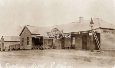
Photograph, Evelyn Hotel, Eltham, c.1911
Postcard image of W. Morris Evelyn Hotel, cnr. Main Road and Pitt Street, Eltham, opposite present hotel. This image is post the 1910 fire which damaged the southern two-storey section. It was rebuilt as single story. The hotel was delicensed in 1919 and became a Dining Room then a boarding house. It was destroyed by fire in the summer of 1931 when at the time it was occupied solely by the McLean family, Hector and Louisa McLean who had five young daughters at the time.Postcard photoRetun to Garnet Burges c/o Judge Bookhotels, evelyn hotel, eltham, main road, pitt street, fountain hotel, william morris -
 Eltham District Historical Society Inc
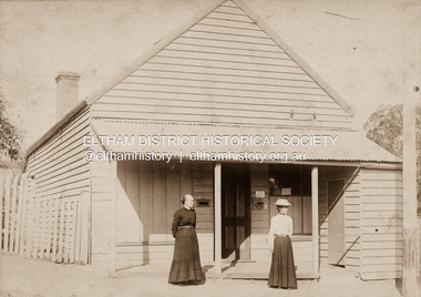
Photograph, Clark Bros, Eltham Post Office, c.1895
Hunniford's Eltham Post Office, Main Road near Bridge Street, Eltham, c.1895. Possibly Miss Anne (Annie) Hunniford, Post Mistress, on left. Annie was post mistress from the mid 1860s until her death in 1928. Photo taken by Clark Bros, 25 Thomas St, Windsor. Clark Bros operated from this address from c.1894 to 1914. Australia Post: Gold brought life to the township - Diamond Valley News, Tuesday July 2, 1985, p17 On February 1, 1854, the first Eltham Post Office was established, commencing an association between the township and the Postmaster-General's Department that has continued for 131 years. At that time, the number of permanent residents would have been fairly small, probably less than 200. The discovery of gold in June 1851, at Anderson’s Creek, some five miles away, and later at Caledonia Diggings, Queenstown (now known as St Andrews), about 14 miles to the north-east, brought large numbers of prospectors passing through the township, hopefully culling the creeks and gullies for the precious metal. This additional "floating population" brought a greater demand for supplies and for communication with the outside world, and so it helped in the development of Eltham. Today, Eltham is a thriving township. It boasts an excellent shopping centre, municipal offices, court house. post office and many other amenities. Eltham continued to develop at a leisurely pace. During 1860, a total of just over 8000 postal articles were handled at the Eltham Post Office. By 1862, the mail route was "to and from Melbourne by way of Eltham and Kangaroo Ground, three times a week, by coach". There was also a branch mail that operated between Eltham and Greensborough, three times weekly. This was also conveyed by coach. Some time between 1864 and 1868 the management of the post office passed from Thomas Hunniford to his daughter, Miss Anne Hunniford, who managed the Eltham Post Office until her death in 1928. A big improvement in communication was provided for Eltham residents when a telegraph office was established at the post office in 1877. During 1923 a manual telephone exchange was provided at Eltham, the first two subscribers being J.J. O’Connor and Eltham Police Station. In 1949 the manual exchange was replaced by an automatic exchange and there were some 150 subscribers. Following the death of postmistress Miss Anne Hunniford in 1928, B.M. Burgoyne was placed temporarily in charge of the office. In 1929, J. N. Burgoyne was appointed postmaster, and he in turn was succeeded by H. C. Burgoyne in 1951. The post office was moved to a new site in 1954, but continued under the charge of Mr Burgoyne. In January 1958 there was a further change of site when the post office was raised to official status and transferred to new premises in Main Rd. William Donoghue was acting postmaster when the new office was opened. In March 1958 Mr W.E. Tovey was appointed postmaster, followed by Douglas McG. Gilmour in 1959. William Donoghue was fully appointed in 1966 and Barry Reichelt followed in 1973, prior to the present postmaster, Peter Jolly in November 1982. Peter is a young man with 18 years' experience. He commenced his training as a postal clerk at the training school in Melbourne in 1968 and was promoted to postal clerk at the Brunswick Post Office in 1969. He was finally transferred as postmaster to Fawkner Post Office in 1980. He has been at Eltham Post Office for the past 2½ years. He is married with one child and lives in Montmorency. The Eltham Post Office employs a staff of 21, of whom seven are indoor staff, 12 are postmen and two are drivers. The postmen in Eltham have an uphill battle delivering mail because of the hilly terrain. Nine of the postmen deliver mail on motorbikes, and the two delivery vans are both four wheel drives. Eltham Post Office services basically a residential area, with deliveries to 5600 homes. This is growing at the rate of 600 homes every 18 months, i.e. about 32 homes per month. At the present rate we will need a new postman every 18 months.Sepia photograph mounted on cardpost office, eltham, main road, anne jane hunniford (1855-1928), clark bros. photo -
 Eltham District Historical Society Inc
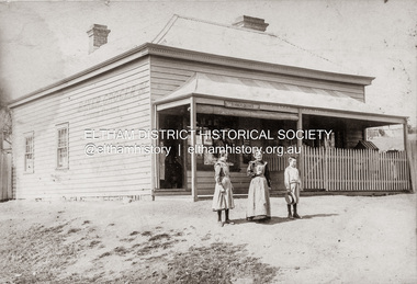
Photograph, Baker and Grocer shop, cnr. Main Road and York Street, Eltham, c.1902
Baker and Grocer store, cnr. Main Road and York Street, Eltham, early 1900s. Sign on side of building "Baker, Grocer & Summer Drinks" This image appears to be of the baker/grocery store after it was purchased in 1902 by Mrs Sarah Burgoyne and her husband, John James Thomas Burgoyne. It is possible that Mrs Sarah Burgoyne is the lady in front of the store with her eldest daughter, Charlotte and youngest son, James. Another daughter (Frances) and the family dog are watching from the doorway. In 1902 Mrs Sarah Burgoyne purchased from Wilfred Henry Johnston, the property on the southern corner of Main Road and York Street, Eltham, which consisted of a store and bakery establishment occupied by Mr. Luther Haley whose lease had expired around the same time. Mr. Haley had not been prepared to leave as he was unable to secure at Eltham a suitable house in which to carry on his business. Wilfred Johnston applied for an eviction of Hayley, which was heard at Eltham Courthouse in August 1902. Hayley advised he was building a place near the railway station which he expected to be done in about three weeks’ time. The court gave him the three weeks to vacate. Hayley’s new premises near the station became the present shopping district’s first shop and he ran it successfully till 1917 when the family moved to Clifton Hill, and he became a publisher. Their eldest child Leslie drowned in the Diamond Creek in early 1904, aged 12.Sepia photograph mounted on cardeltham, eltham bakery, grocer, john james thomas burgoyne, main road, sarah jane burgoyne (nee benson), summer drinks, york street -
 Eltham District Historical Society Inc
Photograph, Eltham Produce Store, Main Road, c.1960
Operated by John McLean and Son Situated just south from opposite Arthur Street, opposite the Eltham Village Shopping Centre. In 1974 the site was the location of the B.P Garage and opposite was the Woolworths Arcade. The Produce Store sold hay and grain. To the right was Garnet Burges' second hand scrap metal and bottles, then the blacksmith shop, which was later taken over by Garnet with second hand furniture and next door to that was Ray Staff's grocery store. The brick building has signage to promote Tanox Paint and Permoglaze products. This building was demolished by 1963 for the BP Evergreen Service Station. Photo taken at same time as Shire of Eltham Pioneers Photograph Collection No. 785 which is a view from near Arthur Street and Main Road intersection.Colour photograph copy of original photoshops, main road, eltham, eltham produce store, tanox paint, permaglaze, produce station, john mclean and son, garnet burges -
 Eltham District Historical Society Inc
Photograph, Old Bridge, Kaylock's Crossing, Brougham Street, Eltham, c.1895
... at the time), traffic had to detour via Brougham Street for some time... at the time), traffic had to detour via Brougham Street for some time ...Brougham Street was created in Josiah Holloway's 1851 subdivision of Little Eltham. It was one of several east-west streets shown on the subdivision plan as crossing the Diamond Creek. The western part was named Wellington Street on the subdivision plan but was later changed to conform with the name of the eastern part as acknowledgement of the continuity of the street. It is not known when the first bridge was constructed in Brougham Street however it was certainly mentioned at Council’s meeting of 2 June 1884 as being in a dangerous state of repair. This photo (c.1895) of an old bridge shows a very low-level simple log girder bridge crossing the creek at a right angle and so the approaches involved bends in the road alignment. This bridge was generally known as Kaylocks Bridge or Kaylock’s Crossing after the owner of the adjoining land. It was most likely built from around the mid-1850s, or a crossing of some fashion established as Richard George Kaylock, butcher of Little Eltham and his wife Emily Ann settled there in 1854. His property was in Wellington Street (now Brougham Street) and apparently extended across the Diamond Creek. The land on the western side of the creek was farmed, the house being on the eastern side. Kaylock's Bridge formed part of the original coach road to Eltham and in 1922 was described as an "old rustic bridge". Its low level and insubstantial construction made it susceptible to flood damage, necessitating frequent closures until repairs could be carried out. In September 1922, Council called for tenders for a new timber bridge to be constructed at Kaylock’s crossing. An engineering assessment carried out for the Council by Macleod Consulting at the time of the replacement suggested that the construction details indicate that it was in the 1900s, however this dating could possibly have been the result of numerous repairs undertaken over the years to flood damage. The tender was awarded to Mr Weller of Kangaroo Ground who commenced work in February 1923 on a higher-level timber trestle bridge. Work was slowed due to illness of the contractor and the accidental death of a man in March 1923 following the collapse of the bank after he had jumped into a hole that had just been blasted. The bridge was completed around July 1923 at which point the old structure was pulled up, marking what was described in the ‘Advertiser’ newspaper as the passing of an old and well-loved landmark in the district. In April 1924 the approach to Kaylocks bridge was washed away during the heavy flooding that destroyed the Main Road bridge. The western side was repaired, and an extra span was added to the eastern side using timber from the destroyed Main Road bridge. The bridge was again severely damaged four months later in August 1924 When a lack of finances delayed repairs to the Bridge Street bridge in 1931 (also referred to as Obelisk Bridge at the time), traffic had to detour via Brougham Street for some time. Local residents feared that the Bridge Street bridge might never reopen. Kaylocks Bridge was constantly subject to damage by floods. In the 1934 flood it was submerged by two feet of water. In more recent times the bridge was again severely damaged by flooding and repairs made. A new bridge and adjoining footbridge were constructed in 2009. Part of a slide show presentation "Bridges & Waterways of the Shire" by Russell Yeoman to the 13 September 1989 Society meeting. The presentation included slides of historic photos from the Shire of Eltham Pioneers collections as well as several recent views.Photo of earliest known crossing of the Diamond Creek at brougham StreetPostcard photo printbrougham street, eltham, wellington street, kaylocks bridge, bridge, diamond creek (creek) -
 Eltham District Historical Society Inc
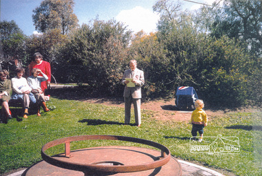
Photograph, Fitting of Time Capsule, Eltham, 1987, 1987
In November 1985 a monument was installed near the corner of Main Road and Pitt Street in Eltham, within the gardens at the front of what is now the Eltham Community and Reception Centre. This monument commemorates Victoria's 150th anniversary and the former location of the Eltham Town Centre, which existed along this section of Main Road, then known as Maria Street. Beneath the site is a time capsule to be opened in the year 2035. A plaque was also erected at this site in October 1987 to commemorate the Shire of Eltham Historical Society's 20th anniversary. The main feature of this monument is a ?tyring disc?, a blacksmith?s implement that was found on this site. This consists of a large iron disc that was used as a platform for fitting iron tyres (like the one shown on top of the platform) to wooden spoked cart wheels. The local blacksmith and wheelwright worked together to assemble the wheel, which was clamped to the platform placed close to the fire. The red hot iron hoop, previously forged to the correct size was lifted with tongs by the blacksmith over the outside of the rim, then hammered down amid flames from the scorching timber. The wheelwright drenched the tyre with cold water as soon as it was in position. A clamp placed on the naff (hub) and screwed down tightly kept the spokes at a constant angle as the tyre cooled. An even pressure from the contracting tyre tightened the joints at each end of the spokes and formed a vice-like grip, which would last for the life of the wheel.Four colour photographs (laser printed on paper); two showing the fitting of the time capsule into the monument and two showing Joh Ebeli during the dedication presentation.eltham, joh ebeli, time capsule -
 Eltham District Historical Society Inc
Document - Folder, Dendy, 2012
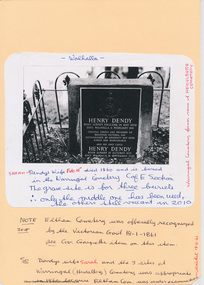
Henry Dendy (1800-1881) was an early settler of Eltham where he operated a flour mill. He donated land for the construction of St Margaret's Anglican Church. EDHS Newsletter No. 168 May 2006 Dendy is best known as the founder of Brighton, but it is not so well known that years later he lived at Eltham for far longer than he lived at Brighton. In 1840 while still in England he bought eight square miles of unspecified land in the Port Phillip District. This entitled him to bring a number of other persons to the colony and in 1841 he arrived at Williamstown in the "York" with his family and 139 others. He took up his land entitlement at what is now Brighton and most of the emigrants settled there. He encountered financial problems and lost his interest in the estate in 1844. He left Brighton in 1847. He successively but not always successfully became a brewer at Geelong, a sheep farmer at Christmas Hills and Upper Moira, a flour miller at Eltham; a sheep farmer again at Werribee and finally a copper miner at Walhalla. Dendy came to Eltham in 1856 after having spent a year in England. The total of the two parcels of land that he bought was about 5 acres (2 hectares) and it included the steam flour mill. . He became prominent in local affairs, serving for a time on the Eltham District Road Board, including one year as President. Dendy' s wife Sarah died at Eltham in 1860 and also in that year he was appointed chairman of a committee to establish a Church of England in Eltham. He donated one of his Pitt Street lots for this purpose and St Margaret's was opened in 1861. In 1867 Dendy sold his mill to W. F. Ford and moved to Werribee and then Walhalla where he remained until his death. He is buried in the Walhalla cemetery. No sign of Dendy's house or mill remain on the Community Centre site but some of the old trees running along the former boundary through the centre of the site could well have been planted in Dendy' s time. Much of this information was obtained from the book ''Henry Dendy and his Emigrants" by L.A. Schumer (Sallas Books 1975). The Society has an extensive file of Dendy information, much of it provided by the late Leslie Schumer. Manilla folder of information. Includes Folder 88 from Harry Gilham Collection which includes EDHS tour notes of St Margaret's Anglican Church, Eltham, 2012, copy of newspaper article, Diamond Valley News, December 15, 1981, copy of newspaper article, The Advertiser, September 2, 1932, photocopy of photograph of graves at Walhalla Cemetery and Warringal Cemetery, photocopies, 6 pages from an unsourced book. henry dendy, st margaret's anglican church, catholic section, eltham cemetery, harry gilham collection, sarah dendy, walhalla cemetery -
 Doncaster RSL Sub Branch
Diary
Diary covers Ivan's time at Truscott airfield in North-Western Australia June 1944 - 45 and covers the construction of the airfield and the first operationsTruscott airfield was one of the most Northerly and therefore the nearest to the fighting at that timeDiary written by sub-branch member Ronald Ivan Smith RAAF. 19 A4 pages enclosed in standard buff coloured file 320 x 240 mm Ivan Smith served in the RAAF from early 1942 to August/September 1945 service number 418708 and the diary covers the period June 1944 to June 1945 -
 Warrnambool and District Historical Society Inc.
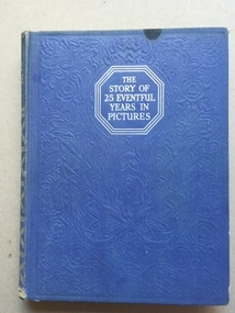
Book, Odhams Press Ltd, The story of 25 Eventful years in Pictures, early 20th century
A collection of photographs of events of the years from 1911 to 1935. It shows many world wide events such as events around Worls War 1,sports events such as horse racing and cricket,scouting, flights over Mt Everest, fashion the fall of the tzars in Russia and other world events such as the vote for women. . It is mainly a British perspective with a number of items relating to the royal family and British politics of the time.This book has historical and social significance as it records in photographs many events which occurred in a very turbulent period of world history. While it has no direct link to Warrnambool it would have been of general interest to local people.Blue cover with silver print on front cover and spine. Front cover has embossing in a floral pattern.Inside front and back covers the paper is patterned in silver and blue with crowns and flags.512 pages with mainly photographs in sepia colours.the story of 25 eventful years in pictures, -
 Warrnambool and District Historical Society Inc.
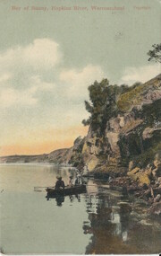
Cards, Post Cards Warrnambool, Early 20th century
These cards have been sent to Christina Lawrance (1889-1970). She was born in Williamstown, Victoria and married James Robertson in 1912. They lived in the Gundagai area of N.S.W. on a property named ‘Nargoon’ (sheep and cattle) and they had five children. One of the daughters, Margaret, married Jeffrey (Bill) Whitehead of ‘Goodwood’ near Hawkesdale and the cards have been passed on to us from a Whitehead descendant. It is not known who sent the cards to Christina Lawrance who would have been 16 or 17 at the time. These cards are of interest because they are of Warrnambool scenes and demonstrate the practice at the time (1906) of sending cards that had photographs of local scenes. The photographs, although printed in great numbers, are of historical interest today. The cards are also of interest because of the recipient’s connection with the Warrnambool area – Christina Lawrance is an important person in the family tree of the Whitehead families today. These are four colour post cards in green, yellow and black tonings. They have photographs of the Hopkins River, Warrnambool and the Hopkins Falls on one side. They all have a penny red Victorian stamp and were posted from Warrnambool in 1906. The address is handwritten in black ink. Addressed to: ‘Miss C. Lawrance, C/O Kirkpatricks Hotel, Mornington, Victoria’whitehead family of ‘goodwood’, christina robertson nee lawrance, history of warrnambool and district -
 Warrnambool and District Historical Society Inc.
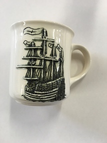
Mug, Mary Rose Ehibition, Late 20th century
This is a souvenir mug produced for visitors to the ‘Mary Rose’ Exhibition in Warrnambool (December 1994 to February 1995). The ship ‘Mary Rose’, built in Portsmouth, England in 1509-10, was historically of major significance. She was the spearhead of a master plan to give England superiority on the high seas. Using new technology of the time, heavy artillery was mounted on the lower decks of this ship and this overloaded the ship. In 1545 she sank in Portsmouth Harbour with the loss of 700 lives as she was about to set sail to defend the English against the French invaders. In 1982 the hull of this ship was raised to the surface and the contents recovered. Over 200 items from the wreck were brought to Warrnambool and displayed in 1994-5 at the Warrnambool Art Gallery. This mug is of interest as it is a memento of the ‘Mary Rose’ Exhibition held in Warrnambool in 1994-5. This exhibition was an important event in the 1990s in Warrnambool and attracted many visitors. This is a cream-coloured china mug with a handle and a raised black and cream image of the ‘Mary Rose’ ship on one side and printed material in brown on the other side. It has the distributor’s name on the bottom with a map of Victoria and a brown dot showing the location of Warrnambool. It is a souvenir of the ‘Mary Rose’ Exhibition held in Warrnambool in 1994-5. “Mary Rose” Exhibition Warrnambool 1994-1995 Lady Bay Creations Warrnambool Australia mary rose ship, mary rose exhibition in warrnambool, history of warrnambool -
 Warrnambool and District Historical Society Inc.
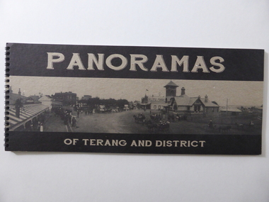
Book, Panoramas of Terang and District, Early 21st century
This is a book containing early 20th century photographs of the town of Terang in the Western District of Victoria. Most of the photographs were taken by Robert Frederick Scott (1877-1953). He was born in Koroit and came to Terang in his early years. He took up coach building and in 1906 he moved to Cobden where he continued coach building with W.J. Silvester. He was regarded at the time as a clever mechanical engineer and was a pioneer in the motor garage business. In the 1930s he was a representative for the Melbourne firm of A.H. McDonald & Co. in the machinery business. He installed milking machines in the Western District and Gippsland. His hobby was photography and he took many photographs in the Western District and supplied photographs to the Victorian Railways for inclusion in the train carriages. This book is of considerable interest as a record of the town of Terang in the early 20th century. The photographs are of high quality and the book will be useful to researchers.This is a soft cover book of 52 pages. It contains black and white photographs of early 20th century Terang and district. The photographs are set in a grey-coloured frame and on the page opposite the photograph is a description of the photograph. The cover is made of lightweight cardboard and the front cover has the title of the book and a black and white photograph of the town of Terang. The book is bound with plastic spirals.history of terang, robert frederick scott, history of western district, warrnambool history -
 Warrnambool and District Historical Society Inc.
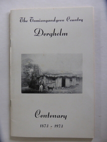
Booklet, The Temiangandeen Country Dergholm, 1973
This booklet gives information on the settlement of Dergholm at the time of the centenary of its founding, 1973. The origin of the name Dergholm is unclear but it may have Irish connections. Europeans came to the area in the 1840s and 50s but it was not until the 1870s that the town was surveyed. Dergholm is in the far west of Victoria 334 kilometres from Melbourne and nearby is Dergholm State Park established in 1982. The booklet was produced for the Centenary Back to Dergholm Committee and the local centenary celebrations. This book is of some interest as it provides information on Dergholm, a settlement in the far west of Western Victoria. This is a soft cover booklet of 52 pages by Alistair Roper. It has a cream-coloured cover with a black and white photograph of early Dergholm on the front cover (Edward Quinn’s house). The booklet has printed material - a President’s Message, an Author’s Note, Acknowledgements, Contents, information on the Dergholm area, including a list of local birds, and References. There are several black and white photographs of the area and its people. The book is stapled. Front Cover: ‘The Temiangandgeen Country, Dergholm Centenary, 1873-1973’dergholm victoria, alistair roper, history of western district of victoria -
 Warrnambool and District Historical Society Inc.
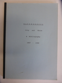
Booklet, City & Shire Bibliography 1847-1988, 1989
... or at the South West College of TAFE in Timor Street Warrnambool ...This 1989 booklet contains lists of publications connected with Warrnambool and District and it was compiled by W. Pinson and M. Johnstone. The publications listed were ones held at the time by the Warrnambool branch of the Corangamite Regional Library Service and the Warrnambool Institute of Advanced Education library. The publications are listed under the headings of Community, Environment, Heritage, Industry and Tourism. Although the information in this book is well out-of-date, it may be of interest to researchers today. The publications may still be available at the Warrnambool Library or at the South West College of TAFE in Timor Street Warrnambool or at Deakin University in Warrnambool. This is a soft cover booklet of 162 pages. It has a pale blue cover and is bound with black tape. It has a map of Warrnambool city, an Introduction, an alphabetical listing of publications concerning Warrnambool City and Shire and an Index. It has some photocopied black and white photographs of Warrnambool (untitled) and a reproduction of the front cover of Osburne’s History of Warrnambool.Front Cover: ‘Warrnambool City and Shire’ ‘A Bibliography 1847-1988’ history of warrnambool, history of western district, warrnambool library -
 Warrnambool and District Historical Society Inc.
Artefact, China Plate, 1922 (painting)
This plate was painted by J.J. Forrester in 1922. John James Forrester, the son of John Lamb Forrester and Maria Hexter, was an architect in Warrnambool in the early 20th century. He had an office in Kepler Street (1910) and in Koroit Street (1916). He lived in the house in Liebig Street that was formerly the first Savings Bank and was erected in 1860 (7A Liebig Street today). Forrester was a staunch member of the Presbyterian Church and was the co-architect for the re-building of the interior of St. John’s Presbyterian Church in Warrnambool after it was destroyed by fire in 1920. John Forrester was also a noted artist of his time and several of his works of art have survived. A landscape by him is in the possession of the Warrnambool and District Historical Society. This plate is one of two painted by Forrester that survive today.This plate, although damaged, is of interest because it was painted by John James Forrester, a Warrnambool artist from the early 20th century. This is a china plate showing a seascape painted by John James Forrester in 1922. It depicts a coastal scene of rocks, birds and sailing boats. The colours are in mauve/brown/ white tonings and are slightly opalescent. The plate has brown/grey handles with one broken and repaired. The plate is oval-shaped with a slight dip and a stand at the base. Front of plate: ‘J.J.F.’ On base: ‘J.J. Forrester 1922’ john james forrester, history of art in warrnamool, history of architecture in warrnambool, history of warrnambool, china painting -
 Warrnambool and District Historical Society Inc.
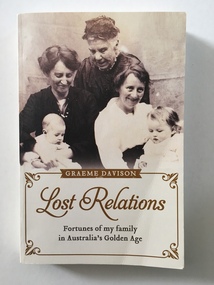
Book, Lost Relations, 2015
This book details the lives of the ancestors of the author, Graeme Davison. It begins with the story of Jane Hewett who migrated with her eight children to Australia from England in 1850. The book not only tells the story of the Hewett families but also gives a wider picture of Australian conditions at the time, making it a valuable social history of Australia in the 19th century and beyond. Graeme Davison, Emeritus Professor of History at Monash University in Melbourne, has also written five other books dealing with aspects of Australian history. This book is of high interest because it is an important social history of Australia detailing the lives of the Hewett families. It is also of significance to those in the Warrnambool region as a member of the Hewett family, John Hewett, settled in Warrnambool with his wife and family and was a local butcher there for some years. This is a soft cover book of 274 pages detailing the family history of the author Graeme Davison. The cover is cream-coloured and has sepia-coloured photographs of the author’s ancestors on the front and back. The printing on the front and back covers is in gold and black. The book contains a Contents page, Introduction, ten chapters on the author’s family history, Acknowledgements, Picture Acknowledgements, Notes and Index. There are many black and white photographs, sketches and maps. Front Cover: ‘Graeme Davison’ ‘Lost Relations’ ‘Fortunes of my family in Australia’s Golden Age’ Inside title page: Signature of author ‘Graeme Davison’ graeme davison, 19th century australian social history, hewett families, warrnambool, history -
 Warrnambool and District Historical Society Inc.
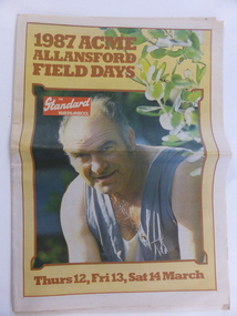
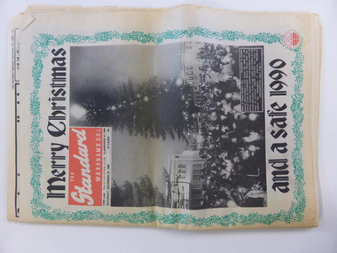
Document, Newspaper The Standard 1987 ACME, March 11 1987
This paper which is a supplement to the Warrnambool Standard presents events and information regarding the Acme Field Days. The Acme Field Days are held each year at Allansford beginning in 1982 and continuing to the present day. Exhibitors and companies from all over the state display their wares at the field days and the three day event usually attracts large numbers of visitors, many of whom come from the agricultural industries. A record of a local event which contains articles and farm practices of the time as well as a comprehensive collection of advertisements from local businesses.Newspaper with coloured photograph on man head and shoulders shot in overalls, with sprig of green across right side of page. Text in brown. Date in brown at bottom of page. Back cover has bright blue border with pink and black text. 32 pages Warrnambool Standard. Acme Field Days Wednesday March 11, 1987warrnambool, warrnambool standard march 1987, acme field days 1987 -
 Warrnambool and District Historical Society Inc.
Document, Newspaper: Warrnambool Standard Christmas 1989, 1989
This newspaper holds a collection of usual articles from local and national news,sports news to letters to the editor, advertisements and a supplement on activities for the holiday period. It contains the local advertisements for houses. The Holiday Guide section has articles on the Moscow Circus, Robert Ullmann, Lake Pertobe playground, local national parks, The film Quigley Down Under and points of interest along the coast. An interesting walk back through time and an interesting record of events and advertisements for businesses at the time.Front page has green holly border with photograph of Carols by Candlelight on the Civic Green. Banner headlines are in black.Back cover has a Christmas poem printed in black on pink background. Green holly border.44 pagesSaturday December 23 1989.warrnambool,, warrnambool standard, warrnambool standard december 1989 -
 Warrnambool and District Historical Society Inc.
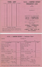
Document, VCFL Hampden District, Mid 20th century
These cards are to be filled out by the timekeeper at football matches in the hampden district which covers the area from Colac to Port Fairy in Western Victoria. The form has space to record the various aspects of time matters for each football game. A common but essential part of the running of sports .Both cards are identical and are bright pink with black text in table form on front and back. V C F L Hampden Districtwarrnambool,, hampden league, hampden district, timekeepers vcfl -
 Warrnambool and District Historical Society Inc.
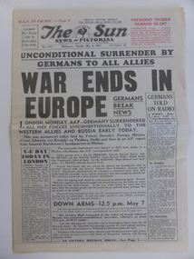
News Sheet, The Sun News-Pictorial 1945, 1945
This Melbourne Sun newspaper of May 8, 1945 contains details of the surrender of Germany in World War Two. The first surrender document was signed at Rheims, France by representatives of Germany, Britain, Russia, France and the United States of America. This paper has no local significance but the event it describes (the end of the war in Europe in May 1945) is of signal importance in world history and affected all in Australia at the time and still does today. The newspaper will be of interest to researchers and useful for display. This is a Melbourne newspaper (The Sun News-Pictorial 1945). It has 16 pages and is printed in black print on a white (now creamy-coloured) background. It has the news of the end of the war in Europe with the surrender of Germany. The newspaper includes black and white photographs, advertisements, cartoons, comic strips and a crossword puzzle. world war two, v.e. day, warrnambool, history -
Warrnambool and District Historical Society Inc.
Book, The happy mother & child by Issi Younger Ross, 1940
This book has been written by Dr Isabella Younger Ross. She was born in Warrnambool to John and Henrietta Younger. The Younger family business was a large department store in Liebig Street and it operated for over 60 years. Isabella (Isie)Younger was educated at Hohenlohe College, Warrnambool, studied medicine at Melbourne University and graduated from the University of Glasgow. She worked for some time in Britain, married John Ross in 1916 and returned to Melbourne in 1917. Here she embarked on a medical career, focusing on child health and mothercraft, an area in which she specialized for 40 years. She was the catalyst for the formation of Baby Health Centres in Victoria and was awarded an O.B.E. for her work in infant welfare. She died in 1956.This is a most important book as it is a key early text on infant welfare and it has been written by Dr Isabella Ross who was born in Warrnambool and received her primary and secondary education in that city. She is very important in the history of infant welfare education in Victoria. The book also contains the signature of the author. This is a hard cover book of 184 pages. The cover is light brown/orange with dark brown print on the front cover and on the spine. The book has an Introduction, eleven chapters of text and an Index. There are several black and white sketches scattered throughout the text. The signature of the author in pencil is on the first page. The cover is slightly scuffed.‘Isie Younger Ross’ younger family, warrnambool, younger stores, warrnambool, infant health education in victoria, isabella younger ross, history of warrnambool -
 Warrnambool and District Historical Society Inc.
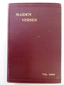
Book, Maiden Verses, 1901
This book contains verses written by Tilly Aston. Matilda Ann (Tilly) Aston was a blind writer and teacher who was born in Carisbrook, Victoria in 1873. She became totally blind at the age of seven. She learned Braille and gained her Matriculation Certificate, spending a short time at Melbourne University. She helped to establish the Victorian Association of Braille Writers and to found the Association for the Advancement of the Blind. She was the first Secretary and later President of the latter association. She was appointed the Head of the School for the Blind in Melbourne and retired from this position in 1925. She published several books of verse and prose. There is a Parliamentary electorate in Victoria called Aston. This book is of considerable interest because the author, Tilly Aston, has an important place in Australian literature. The book, ‘Maiden Verses’ has a local Warrnambool connection as it contains a poem written about Warrnambool, a town which Tilly Aston visited on occasions.This is a hard cover book of 146 pages. It is a book of poems written by Tilly Aston. The cover is dark red with the printing on the spine and on the cover in gold lettering. There is at least one page at the front of the book torn out. There is a receipt for the purchase of the book pasted on to the inside of the front cover. The date of the receipt made out to ‘John F. Watts’ is for three shillings and sixpence (1900). The book is bound with glue and string.Signature on the first page: ‘John F. Watts, Nov. 18th 1900’ (or maybe ‘1901’)tilly aston, australian literature, history of warrnambool -
 Warrnambool and District Historical Society Inc.
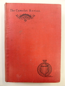
Book, Speaking Personally - W Murdoch, 1887/1888
These two important books are part of a series produced in the 1880s but they have widely-different content. One describes the natural history of the Parish of Selborne in the County of Hampshire in England. It was written by the British naturalist and ornithologist, Gilbert White and first published in 1789. Since that time it has been republished over 300 times right up to the present day. It is notable for its charm and simplicity and for its description of a pre-industrial England. The other is by the American author, Walt Whitman, first published in 1871. It is a major work of comparative politics and expounds on the influence of the Louisiana Purchase and the expansion of the American spirit and character. It also denounces the post-Civil War materialism that had spread at that time in America. These books are of interest because of their antiquarian nature but they are mostly of local Warrnambool interest because of their inscriptions. The books belonged to William Hugh McMahon (1862-1936). William McMahon commenced a legal practice in Warrnambool in 1894, firstly in Liebig Street and later in Kepler Street. He was a prominent lawyer in Warrnambool for 30 years and a staunch adherent of the Presbyterian Church. He and his family lived at ‘Glenrye’ at the corner of Ardlie Street and Botanic Road, a site where the St. John of God Hospital was later established. These two accompanying volumes are in the Camelot Series (1887 and 1888). They are hard cover books with red covers and two ornamental patterns on the front cover (stylized urn and fan shapes). The urn pattern is repeated on the spines. ‘The Natural History of Selborne’ has 366 pages (a Preface and Chapters on the Natural History of Selborne, a Naturalist’s Calendar and Observations on Various Branches of Natural History) and ‘Democratic Vistas’ has 175 pages (a Preface and 12 Chapters). The latter has the remains of a label stuck to the front cover. The handwriting on the inside first pages are in black ink.Book One: ‘W.H.McMahon, June 24th 1889, Warrnambool’ Book Two: ‘W.H.McMahon, Sept. 4th 1891, Warrnambool’ gilbert white, english natural history, walt whitman, american politics, william mcmahon, solicitor, warrnambool., warrnambool history