Showing 3339 items matching "george black"
-
 Hume City Civic Collection
Container - Tin, LODGE/FORD/PLUG
This tin held a Lodge sparking plug.Orange coloured rectangular small tin with black writing on the hinged lid. it has two small round holes and two long narrow cut outs on one side.LODGE/FORD/PLUG/REUSE IF UNSEALED...george evans collection, commercial packaging -
Lakes Entrance Historical Society
Photograph
Daughter of George and Sarah Grant. Family living at Metung after 1872Black and white photograph of Marion Elizabeth Grantgenealogy -
 Parliament of Victoria
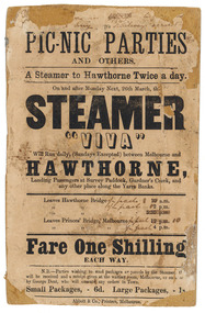
Flyer for the steamer Viva, Abbott & Co., Printers, c.1860
The "Viva" was a steamboat operated by George Dent that ran on the Yarra River between Princes Bridge and Hawthorn Bridge from 1860-1861. Printer flyer pasted onto cardboard advertising ferry services between Melbourne and Hawthorne [sic]. Corrections to ferry departure times are in black handwritten ink. Flyer has losses around edges and stains from 'blue-tack' verso. Black ink, printed recto: "PIC-NIC PARTIES/ AND OTHERS./ A Steamer to Hawthorne Twice a day./ On and after Monday Next, 26th march, the/ STEAMER/ "VIVA"/ Will Run daily, (Sundays Excepted) between Melbourne and/ HAWTHORNE,/ Landing Passengers at Survey Paddock, Gardner's Creek, and/ any other place along the Yarra Banks./ Leavers Hawthorne Bridge 10 a.m./ 2 p.m./ 5.30 p.m./ Leaves Princes' Bridge, melbourne 12 p.m./ 4 p.m./ Fare One Shilling/ EACH WAY./ N.B.-Parties wishing to send packages or parcels by the Steamer th(?).../ will be received and a receipt given at the waiting room, Melbourne, or on board.../ by George Dent, who will execute any orders in Town./ Small Packages, - 6d. Large Packages, - 1s/ Abbot & Co., Printers, Melbourne.viva steamboat, dent, george, hawthorne, yarra river, princes bridge, melbourne, survey paddock, gardner's creek -
 Williamstown High School
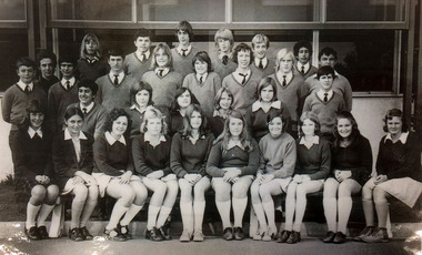
Form 3C 1973
Laminated copy of black and white photograph of Williamstown High School form 3C of 1973On back: Back row L-R: John Meertens, Frank Celeste, Mark Bates, Chris Herbert, Glenn Kershaw, Nicholas Defina Third row: Alan Young, M W Watkins (Teacher), Tahki Hatzimonolis, Michael Piritidid, Anthony Ferguson,Peter Nedeljkovic, Clive Rosewarne,Wayne Brown, Jim Nanos. Second row: George Ibrahim, Robyne Richardson, Sheryl Virgona,Mary Schloetzer, Margaret Sloane, Paul Markopoulos. First row: Deborah Ellwoood, Maria Toucomonavic, Esther Simin, Fiona Fitzgerald, Kathryne Pliatsiari, Karen Fryer, Lesley Hunt, Karen Cartens, Anna Jcincic, Janet Brindley.williamstown high school, class photographs, 1973, form 3c -
 Robin Boyd Foundation
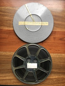
Film, 1970
This film is a curated collection of iconic early Australian films. There are three sequences. The first sequence consists of a segment of 1908 boxing match between Jack Johnson and Tommy Burns at Sydney Stadium, 1906 Hawthorn street scenes, and a 1909 VFL Football final. The second sequence consists of 1896 Melbourne Cup, 1906 Sydney street scenes and Baldwin Spencer footage of Australian indigenous ceremonial dance. The third sequence consists of a bush ranger scene from "Robbery Under Arms" (1920), a great escape scene from "The Sentimental Bloke" (1919) and Sydney Harbour boat chase from "Let George Do It" (1938). These sequences are repeated several times. These would have been selected by Robin Boyd for screening at the Australian Pavilion at Expo 70 in Osaka, where Robin Boyd was Exhibitions Architect. 16mm black and white silent film inside a circular metal canister with lid. Duration-39:33 minutes. Head out - Loose archival wind placed in archival film storage container.expo 70, jack johnson, tommy burns, melbourne cup, spencer baldwin, early australian film, robin boyd -
 Robin Boyd Foundation
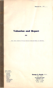
Document, George L Steele, Sworn Valuer, Valuation and Report, 14.04.1961
This is a valuation and report on the property at the south east corner of Tiller Street and Burwood Road, East Burwood, as part of the estate of Mrs Edith Boyd, the mother of Robin Boyd. This was commissioned by John Penleigh (Pat) Boyd, Robin Boyd's brother. Edith Boyd died on 31 March 1961.Two page document plus a small black and white photograph in a thick paper folder. -
 Old Colonists' Association of Ballarat Inc.
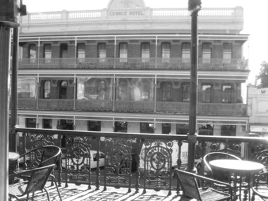
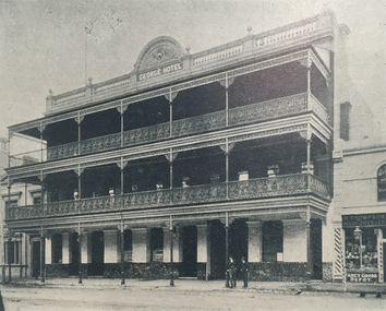
Photograph - Photograph - Black and White, Lisa Gervasoni, The George Hotel, Ballarat, 23/03/2017
Black and white photograph of the George Hotel in Lydiard Street, taken from the balcony of the Old Colonists' Hall.george hotel, ballarat old colonists' club, old colonists' hall, balcony -
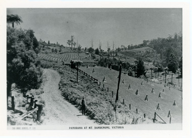
 Mt Dandenong & District Historical Society Inc.
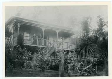
Photograph, Home of George and Sarah Barber c1905
George and Sarah Ann Barbers home "Forest Edge' on Barber's Road. Jabez Richardson (father of Sarah Ann) and his wife Sarah jane are standing on the front verandah. An unknown male is also in the picture.Black and white photograph showing four adults standing on the front verandah of a house. Reverse of photograph has handwritten description by John Lundy-Clarke.Jabez and Sarah Jane Richardson on verandah of home of their daughter Sarah Ann (Mrs Barber) 1905. Sarah jane died 1906. Jabez died 1908.forest edge, george barber, sarah ann richardson, sarah ann barber, jabez richardson, sarah jane richardson -
 Mt Dandenong & District Historical Society Inc.
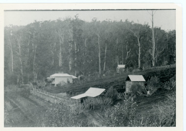
Photograph, George Barber's Home Forest Edge after 1912 Looking South West, c1912
George Barber built a homestead later named Forest Edge on Barber's Road and lived there with his wife Sarah Ann (nee Richardson).Black and white photograph showing the side view of a house and three outbuildings. Reverse of photograph has handwritten description by John Lundy-Clarke.George Barber's home on bend of Barber's Road on Lot 25, Village Settlement. Showing passionfruit plantation. Buggy shed top right. Hay shed lower right. Stables, cart shed and men's quarters lower left about 1912. Photo copied by JLC in 1973.forest edge, george barber, sarah ann barber, kalorama, barber's road -
 Mt Dandenong & District Historical Society Inc.
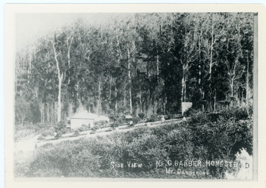
Photograph, Side View Mr G. Barber Homestead Mt Dandenong, c1905
Built in 1898 by early settler George Barber the property is still in existence today. It was the home of George, wife Sarah Ann and daughter Ethel.Black and white photograph showing te side view of George Barber's home, later named Forest Edge. c1905. Reverse of photograph has handwritten description by John Lundy-Clarke.Barber's home on Olinda Creek. Lot 25 Sect 1 Village Settlement. Home of George Barber and wife Sarah Ann (nee Richardson). Daughter Ethel.Was bought by Munnerley later Sangster and Kinnear. Later known as Forest Edge. Buggy and wagon shed on right. Photo copied 1973 by JLC. -
 Mt Dandenong & District Historical Society Inc.
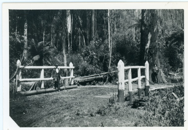
Photograph, Barber's Bridge on Olinda Creek
John Lundy-Clarke grew up in the Kalorama/Mt Dandenong area and later in life (1972-74) began to write a comprehensive history of the area working from an original settlement map in an effort to cover all areas. Barbers Bridge was named after George Barber, an early settler.Black and white photograph showing a man standing on a bridge over the Olinda Creek. 1910Handwritten n reverse: Barbers Bridge on Olinda Creek 1910. This was a ford crossed by the road after Isaac Jeeves selected allotment “C” “Jeeves Saddle” in 1871 and stopped travel through his property. The bridge has been built several times but at time of writing (1974) is replaced by a culvert consisting of two pipes two feet six inches wide. They are quite incapable of carrying the maximum flow of the creek and will be swept away.lundy-clarke, barber, barbers bridge, isaac jeeves, jeeves saddle, bridge, olinda creek -
 Mt Dandenong & District Historical Society Inc.
Photograph, View Up Valley At Kalorama
John Lundy-Clarke grew up in the Kalorama/Mt Dandenong area and later in life (1972-74) began to write a comprehensive history of the area working from an original settlement map in an effort to cover all areas. The building in the centre of the photograph is 'Kia-Ora' guest house. Situated on Barber’s Road, ‘Kia-Ora’ was built in 1912 by George Barber. It was later leased by a Mrs Pemberthy. “Kia-Ora’ was one of four places connected when the telephone was brought into the district in 1912. The other places were ‘Mountjoy’, ‘Cherry Farm’ and ‘Callum House’. ‘Kia-Ora’ was burnt down in 1924. Black and White copy of section of a Rose Series postcard. Shows view up the valley at Kalorama with a decorative building centre middle of photograph. Handwritten description by John Lundy-Clarke on reverse.View up valley at Kalorama from near junction of Barbers and Doughty’s Rds. “Kia Ora” guest house in centre. Paynter’s “Iona” top left with “Kalorama” to its right. About 1912. Rose Series copied by JLC 1973.kalorama, kalorama valley, john lundy-clarke, barbers road, george barber, kia-ora, guest house, iona -
 Mt Dandenong & District Historical Society Inc.
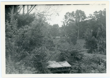
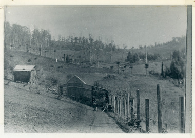
Photograph, View from George Barber's Home To His Stables
John Lundy-Clarke grew up in the Kalorama/Mt Dandenong area and later in life (1972-74) began to write a comprehensive history of the area working from an original settlement map in an effort to cover all areas. This photograph was taken by John Lundy-Clarke in 1973 to show changes to the environment sine 1905.Black and white photograph with tangled bush and small shed in foreground looking towards a cleared area. Handwritten description on reverse written by John Lundy-ClarkeView from Barbers drive to his stables close to where 1905 picture was taken. Stables in foreground. Looking towards Gap. Taken JLC November 1973.barbers road, john lundy-clarke, kalorama -
 Mt Dandenong & District Historical Society Inc.
Photograph, View of the Kalorama Valley c1905
John Lundy-Clarke grew up in the Kalorama/Mt Dandenong area and later in life (1972-74) began to write a comprehensive history of the area working from an original settlement map in an effort to cover all areas. This photograph c1905 is looking up from George Barber's house 'Forest Edge' on Barbers Road. 'Forest Edge' was built c1898 and was the home of George Barber and his wife Sarah Ann (nee Richardson). The buildings in the foreground are the stables and hayshed.Black and white photograph showing two small buildings in the foreground with cleared hills behind. Handwritten decription on back by John Lundy-ClarkeA 1905 view of the Kalorama Valley towards the Gap. Barbers stables in foreground with hayshed on left. Tait’s house in centre of picture with Logans in the same fold above the hayshed. “Kalorama” is centre of Gap with Paynter’s “Iona” on its left with stables to its left. It was from one of these trees on the top left that the runaway log was cut that leaped over Barbers Road (at the top edge of the cleared land) then over Logan’s house in one bound in 1930.george barber, sarah ann barber, john lundy-clarke, forest edge -
 Mt Dandenong & District Historical Society Inc.
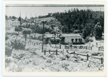
Photograph, View From Ernest Road To Site Of "Kia-Ora"
John Lundy-Clarke grew up in the Kalorama/Mt Dandenong area and later in life (1972-74) began to write a comprehensive history of the area working from an original settlement map in an effort to cover all areas. The photograph taken c1973 from Ernest Road looks over the site of the Kia-Ora guesthouse which is marked by the oalm tree that can be seen at the front of the flat roof close to the gum tree trunk. Situated on Barber’s Road, ‘Kia-Ora’ was built in 1912 by George Barber. It was later leased by a Mrs Pemberthy. “Kia-Ora’ was one of four places connected when the telephone was brought into the district in 1912. The other places were ‘Mountjoy’, ‘Cherry Farm’ and ‘Callum House’. ‘Kia-Ora’ was burnt down in 1924.Black and white photograph showing a house with water tank in right foreground and another flat roof centre foreground. There is a handwritten description by John Lundy-Clarke on the reverse.View 1973 from corner of Ernest Rd and Outlook Drive Lot 24 Village Settlement looking over the site of “Kia Ora” to the pioneers clearings. The palm tree seen above the flat roof (Rex) on left, is on the exact site of “Kia Ora”. Photo JLCernest road, john lundy-clarke, kia=ors, guest house, guesthouse -
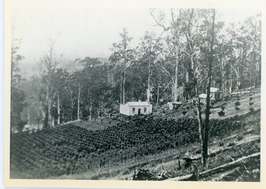 Mt Dandenong & District Historical Society Inc.
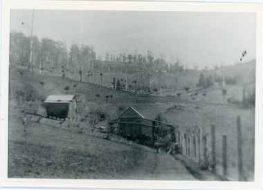
Photograph, Walker's LOT 2
Lot 2 was bought by Harry Walker in the early 1900s. Harry was married to Eva Hand, one of the six daughters of Thomas and Eliza Hand. Harry cleared the land and planted half with raspberries that remained productive until c1928. Harry's son William took over the property. The land was cut in half when the new CRB road went through in the early 1920s. John Lundy-Clarke grew up in the Kalorama/Mt Dandenong area and later in life (1972-74) began to write a comprehensive history of the area working from an original settlement map in an effort to cover all areas.Black and white photograph showing a single storey white house in the centre surrounded by crops. Handwritten description on reverse by John Lundy-Clarke.VIEW 1908 OVER LOT 2 SECTION 1 VILLAGE SETTLEMENT. TAKEN FROM RIDGE ROAD THEN MAIN ROAD FROM HALFWAY BETWEEN MOUNTJOY AND FALLS RD. CRB MAIN RD RUNS BEHIND WALKER’S HOUSE. The house seen in the vista among the tall trees beyond the raspberry patch is “Forest Edge” which was George Barber’s home when the picture was taken. The tall trees to the right of the vista were on Price’s LOT 18 and it was while cutting up one of these for firewood that a length of log weighing about ½ a ton got away downhill and leaped in one bounce over Barbers Road and Logan’s house – 1931.harry walker, william walker, eva hand, crb road, raspberries, kalorama -
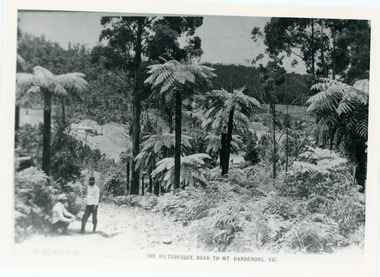 Mt Dandenong & District Historical Society Inc.
Photograph, View From Doughty's Road 1913
Mt Calvin, the homestead of Jeanie and Willie Richardson can be clearly seen in the clearing above the men in the picture. The white roof of the Barber homestead is on the right of the picture. A landslide in 1934 destroyed the tree ferned area. John Lundy-Clarke grew up in the Kalorama/Mt Dandenong area and later in life (1972-74) began to write a comprehensive history of the area working from an original settlement map in an effort to cover all areas.Black and white photograph that is a copy of a Rose series postcard titled 'The Picturesque Road to Mt. Dandenong. Vic.' It shows two men (probably Rose Series employees), one sitting and one standing at the edge of an unmade road. Large tree ferns line the roadside. Handwritten inscription on reverse by John Lundy-Clarke1913 View east from Doughty’s Road showing Jeannie Richardson’s home through the gap in the trees. A little to the right of and below centre of picture can be seen George Barber’s home with Barbers Road turning around the wagon shed that was a little up the hill from the house. The tree ferns in the picture were destroyed in the landslide of 1934. In the distance at the right can be seen F.M. Childs Homestead complex with the Richardson paddocks beyond it.mt calvin, jeanie richardson, willie richardson, george barber, landslide, tree fern -
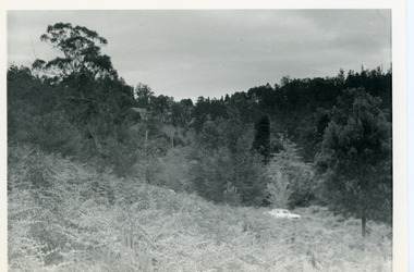 Mt Dandenong & District Historical Society Inc.
Photograph, View Up Valley Towards Kalorama Gap 1973
John Lundy-Clarke grew up in the Kalorama/Mt Dandenong area and later in life (1972-74) began to write a comprehensive history of the area working from an original settlement map in an effort to cover all areas. This photograph would have been taken to show the changes in the area over the years. Kalorama Gap is now called Five Ways. 'Kia-Ora ' was a guest house built by George Barber. It is no longer standing.Black and white photograph showing a bush scene with a white car visible on the right. Handwritten inscription on reverse by John Lundy-Clarke1973 View up Valley towards Kalorama Gap from what was Crooks LOT 24. White car is on Barbers Road and site of “Kia Ora” is to right of it.kalorama, kalorama gap, five ways, barbers road, george barber, kia-ora -
 Mt Dandenong & District Historical Society Inc.
Photograph, View From Corner of Doughty's Road and Barbers Road 1913
John Lundy-Clarke grew up in the Kalorama/Mt Dandenong area and later in life (1972-74) began to write a comprehensive history of the area working from an original settlement map in an effort to cover all areas. Taken c1913, this photograph gives a clear indication of where significant buildings were located in relation to one another. Barbers Road is running through the picture with the guest house 'Kia-Ora' , built by George Barber in the centre. High on the skyline on the left is the 'Mountjoy' guesthouse, indicating the location of The Gap, or FiveWays. The small 'boxy' house above 'Kia-Ora' is 'Iona' built by the Paynter family who also built 'Mountjoy'. The Jeeves property 'Kalorama' is to the right of 'Iona' and this is the area you now look to from the FiveWays Lookout. The man in the photo is wearing a trilby hat so is probably a Rose Series employee - a feature in many Rose Series postcards.Black and white photograph that is a copy of Rose Series Postcard # 156. A man can be seen walking down an unmade road with haystacks to his right. Buildings and crops can be seen on the hillsides. Handwritten inscription on reverse by John Lundy-ClarkeView from corner of Doughty’s and Barbers Road 1913. “Kia Ora” in centre Paynter’s “Iona” near center skyline above “Kia Ora” with “Kalorama” on its right and Peter’s hut of the time below it among orchard trees. “Mountjoy” is on left skyline. W. Haye’s home is centre left. Hay paddock is Barbers Lot 25 Village Settlement.kia-ora, iona, kalorama, mountjoy, guesthouse, guest house, barbers road, doughty's road, paynter, jeeves, george barber -
 Mt Dandenong & District Historical Society Inc.
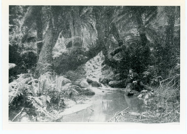
Photograph, The Olinda Creek, 1910
... in the gully behind the house of George Barber. Olinda Creek Black ...The Olinda Creek in 1910. Most probably in the gully behind the house of George Barber.Black and white photograph with a creek running through the centre of ferns and tree ferns. A man sits beside the creek on the RHS.olinda creek -
 Mt Dandenong & District Historical Society Inc.
Photograph, The Olinda Creek, 1910
... George Barber tree fern Black and white photograph with a creek ...Taken in 1910, this section of the Olinda Creek is in the gully behind the home of George Barber.Black and white photograph with a creek running through the centre surrounded by ferns and tree ferns. A man is leaning on rocks beside the creek on the RHS.olinda creek, creek, george barber, tree fern -
 Mt Dandenong & District Historical Society Inc.
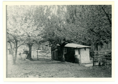
Photograph
French Louis Merci is shown as J.L. Merci on the settlement map, having selected Lot 26 in the Village Settlement in 1901.It was a 5 acre Lot bordering Barbers Road and the Dray Track (now Link Road). Louis shared his hut for some time with Peter the Swede. When Louis became ill with cancer and could no longer work he sold his property to George Barber in return for a weekly payment.Black and white photograph of hut in row of blossoming trees.french louis, louis merci, j l merci, peter the swede, george barber, link road, barbers road, hut, dray track -
 Mt Dandenong & District Historical Society Inc.
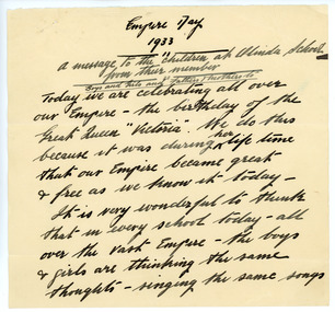
Document - Speech, Empire Day 1933
This document is a speech titled "Empire Day 1933. A message to the children at Olinda School from their member". It is signed G H Knox. It was written by Sir George Hodges Knox and read to the children at Olinda School as part of the Empire Day celebrations in 1933. Sir George Hodges Knox (1885-1960) was a veteran of WW1 and was elected to the Ferntree Gully Shire Council in 1922. He held this post until 1927.The City Of Knox is named after him. He won the Victorian Legislative Assembly seat for Upper Yarra in 1927 for the Nationalist Party. He became Speaker for the Victorian Parliament in 1942 and remained there until 1947. Between 1945 and his death in 1960 he held the seat of Scoresby. He was knighted in 1945. The celebration of Queen Victoria's birthday on May 24 was renamed Empire Day in 1903 after her death in 1901. Empire Day was observed in state schools from 1905 with a program of addresses, pageants and patriotic songs, with children swearing allegiance to King and Empire with a loyal declaration. The last celebration of Empire Day in Australia took place in 1958. Five sheets of unlined paper that appear to have been torn from a writing pad with a speech handwritten in thick, black fountain pen commemorating Empire Day.olinda school, sir george hodges knox, empire day, speech, city of knox, knox, olinda, school, celebration -
 Old Colonists' Association of Ballarat Inc.
Image, The George, Ballarat, c1903, c1903
... hotels ballarat Black and white image of The George Hotel ...Black and white image of The George Hotel in Lydiard Street, Ballarat.the george hotel, hotels, ballarat -
 Old Colonists' Association of Ballarat Inc.
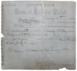
Document, Form of Register Ticket made out to William Fittall, 1862
Small ticket stub for a Form of Register TicketForm of Register Ticket No. 224 Schedule XXVII By Law XIII February 11th 1862 I, P.P.FitzPatrick Mining Registrar for the No 2 division of the Mining District of Ballaarat, have this eleventh day pf February 1862 registered Willia Fittall for a residence claim, 66 feet by 82 1/2 feet situated east of Peel Steeet near Black Hill Gully (signed) William Fittall on 28 January 1862sailor, immigration, thomas paterson, greenock, george dempster, chevalier -
 Mt Dandenong & District Historical Society Inc.
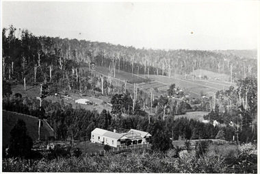
Photograph, The Settlement of Harmony Vale 1913, 1913
View of the settlement of Harmony Vale taken in 1913 with the guest house Kia Ora, built by George Barber in 1909, in the foreground. This photograph has a detailed inscription on the back handwritten by John Lundy-Clarke.The settlement of Harmony Vale 1913. The large home in foreground is the Guest House “Kia Ora” owned by George Barber on Lot 25 of the Village Settlement. The house above it to the left was Richardson’s house. The home of Jeanie who had left it when the picture was taken.The buildings furthest to the right of “Kia Ora” were the homestead of Isaac Jeeves of 1863 – 1871 the building furthest right with the black opening in it was the house with the tree fern floor. The flat ground above and left of Isaac’s pointed roof barn is where the creek changed its course in the 1934 flood and destroyed £4000 worth of the Rowse family’s tulip bulbs. Above the flat is Francis Matthew Child’s homestead, in the creek to the right of which can be seen the horizontal structure of the swing bridge to the sawmill of the Childs Bros which cannot be seen but in the forest to the right of the mill (bridge) can be seen a number of logs in the mill yard. The two cleared strips immediately behind Childs home were the Richardson’s original holdings and the house in the gully at the far side of the great clearing is that of the guest house “Glenrivers” belonging to W Lucas and his wife Catherine nee Child. The Richardson homestead “Harmony Vale” is behind the forest trees in the right centre. The picture gives a full view of how the settlement was cut into the centre of the great forest. george barber, kia ora, harmony vale, barber, jeanie richardson, richardson, child, matthew child, kia-ora guest house, guest house, glenrivers -
 Mt Dandenong & District Historical Society Inc.
Photograph, View From George Barber's Home On Olinda Creek Towards The Gap. c1905, 1905
Black and white photograph showing view towards The Gap (Jeeves Saddle), (Five Ways) taken c1905. Detailed inscription on back handwritten by John Lundy-Clarke in 1973.1905 (c ) view from Barber’s home on Olinda Creek, towards the Gap, then known as Jeeves Saddle. Barber’s stable in foreground. “Shiloah” Complex centre right. Tait’s house in gully just left of centre. Logan’s house can just be seen under magnifier at top of same gully near line of Barber’s Road. “Kalorama” just below lowest portion of Gap skyline with Barnes (Paynters) house “Iona” to its left. Photo copied 1973. JLC. george barber, shiloah, kalorama, iona, olinda creek, the gap, jeeves saddle, tait, paynter, barber -
 8th/13th Victorian Mounted Rifles Regimental Collection
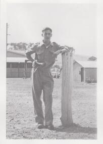
Photograph
... . atkinson george " Sgt. G. Atkinson " Black and white photograph ...The 8th/13th Victorian Mounted Rifles was raised as a regiment of the Royal Australian Armoured Corps on 1 May 1948 with Headquarters in Melbourne and squadrons in Sale, Benalla/Wangaratta and Albury. In 1955 Regimental Headquarters moved to Wangaratta and a second squadron was located at Albury. The Sale squadron transferred to 4th/19th Prince of Wales’s Light Horse. In 1977 8/13 VMR Regiment was reduced to an independent squadron A Squadron 8th/13th Victorian Mounted Rifles and in 1991 was linked with 4th/19th Prince of Wales’s Light Horse forming the VMR Squadron of that regiment. George Atkinson joined 8th/13th Victorian Mounted Rifles in 1948.Unique collection of photographs showing the first years of an armoured regiment of the post-Second World War era Citizen Military Forces showing equipment, uniforms, training and social activity and some personalities.Black and white photograph of soldier in khaki drill uniform leaning on post. One of a collection of photographs of 8th/13th Victorian Mounted Rifles Regiment between 1948 and 1951." Sgt. G. Atkinson "atkinson george -
 8th/13th Victorian Mounted Rifles Regimental Collection
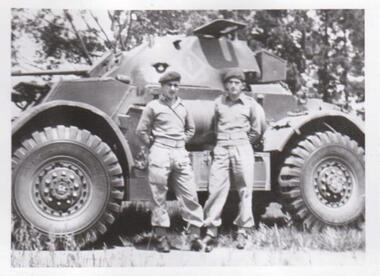
Photograph - George Atkinson and Alan Cunningham
The 8th/13th Victorian Mounted Rifles was raised as a regiment of the Royal Australian Armoured Corps on 1 May 1948 with Headquarters in Melbourne and squadrons in Sale, Benalla/Wangaratta and Albury. In 1955 Regimental Headquarters moved to Wangaratta and a second squadron was located at Albury. The Sale squadron transferred to 4th/19th Prince of Wales’s Light Horse. In 1977 8/13 VMR Regiment was reduced to an independent squadron A Squadron 8th/13th Victorian Mounted Rifles and in 1991 was linked with 4th/19th Prince of Wales’s Light Horse forming the VMR Squadron of that regiment.Unique collection of photographs showing the first years of an armoured regiment of the post-Second World War era Citizen Military Forces showing equipment, uniforms, training and social activity and some personalities.Black and white photograph of two soldiers wearing drill uniforms , boots, web anklets, belt and berets standing beside a Staghound Armoured Car.One of a collection of photographs of 8th/13th Victorian Mounted Rifles Regiment between 1948 and 1951." George Atkinson and Alan Cunninghamatkinson, cunningham, 8/13 vmr, staghound -
 8th/13th Victorian Mounted Rifles Regimental Collection
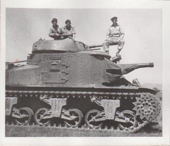
Photograph
... Kothoff, Alan Cunningham and George Atkinson ." Black and white ...The 8th/13th Victorian Mounted Rifles was raised as a regiment of the Royal Australian Armoured Corps on 1 May 1948 with Headquarters in Melbourne and squadrons in Sale, Benalla/Wangaratta and Albury. In 1955 Regimental Headquarters moved to Wangaratta and a second squadron was located at Albury. The Sale squadron transferred to 4th/19th Prince of Wales’s Light Horse. In 1977 8/13 VMR Regiment was reduced to an independent squadron A Squadron 8th/13th Victorian Mounted Rifles and in 1991 was linked with 4th/19th Prince of Wales’s Light Horse forming the VMR Squadron of that regiment.Unique collection of photographs showing the first years of an armoured regiment of the post-Second World War era Citizen Military Forces showing equipment, uniforms, training and social activity and some personalities.Black and white photograph of three soldiers sitting on a General Grant tank. One of a collection of photographs of 8th/13th Victorian Mounted Rifles Regiment between 1948 and 1951." Sgts. Ken Kothoff, Alan Cunningham and George Atkinson ."