Showing 179035 items
matching streets
-
 Stawell Historical Society Inc
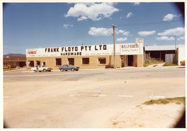
Photograph, Pleasant Creek Special School, Frank Floyd Pty Ltd. Hardware Store, Wimmera Street Stawell Nov 1975, Nov 1975
Photographs taken by teacher at Pleasant Creek Training Centre to help train students in living skills and becoming familiar with what shops sold. Part of socializing students for leaving the training centre.Wimmera Street Stawell education, streetscape -
 Ballarat Heritage Services
Photograph - Photograph - Colour, Darwin Main Street, China Town, c1912, 1912
The main street of Darwindarwin, china town -
 University of Melbourne, Burnley Campus Archives
Photograph, James Leslie Provan, Burnley 1942 Album Page 2, 1942-1943
Swan Street entrance.swan street, entrance, burnley, 1942, j.l. provan -
 Hume City Civic Collection
Photograph, c 1980s
The photograph although recently taken shows the original settled area in Sunbury, which included Goonawarra Vineyard and Macedon Street which was once the business centre of Sunbury township before the railway was established.A coloured photograph of Sunbury Township looking west from above Jacksons Creek and Goonawarra Winery. Macedon Street can be seen in the middle distance and Mt. Holden and Burke Hill are across the skyline.sunbury township, mt. holden, burke hill, francis, james goodall, barnier, john, jacksons creek, goonawarra winery, george evans collection -
 Federation University Historical Collection
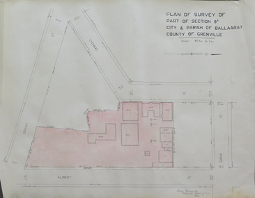
Plan, Plan of Survey of Part of Section 9A City & Parish of Ballarat County of Grenville (Albert Street frontage), 1932
The M.B. John Trade Building was built on the Albert Street Frontage..1) Plan of SMB showing Albert, Grant, Lydiard and Dana streets, on paper with colored highlights undertaken by Ballarat School of Mines student George Murrowood in 1932 .2) Hand written page by George Murrowood, of technical description of land surveying Grade II 1932ballarat school of mines, surveying, george murrowood, albert street, alumni, m.b. john building, architectural plan -
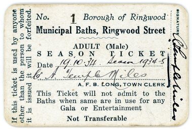 Ringwood and District Historical Society
Document, Packet: Municipal Baths, Borough of Ringwood- Cuttings, Certificates, Correspondence. 1928-1977
Miscellaneous documents related to the Ringwood Baths in Ringwood Street and the Ringwood Swimming Club.Packet includes: . 3742a- Season Ticket No 1 for the Municipal Baths, Ringwood Street, belonging to Cr A Temple Miles, dated 19.10.34 Season 1934-35. . 3742b- Typed document advertising the First Grand Aquatic Carnival at the Public Swimming Pool at dublin Road, Ringwood East. . 3742c- Invitation to Mr & Mrs R Pullin from the City of Ringwood for the Official Opening of Fred. Dwerryhouse Swimming Pool at Jubilee Park on 31st October, 1970. . 3742d, e, f- Early correspondence and reports on running of the Baths 1934 to 1937. . 3742g- Letter dated 19.9.1936 from the Ringwood Swimming Club to Ringwood Council requesting Clubrooms at the Baths. . 3742h- Two cards listing monthly items of interest dated 1925 to 1942. . 3742i- Ringwood Swimming and Life Saving Club Membership Cards for Kaye Maidment and William Maidment dated 9.11.58. . 3742j- Newspaper cuttings from 1928 to 1946. -
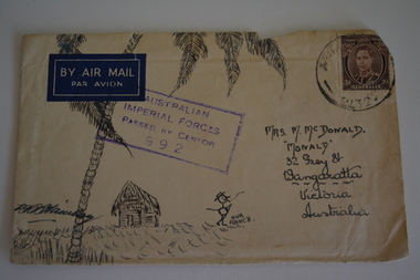 Wangaratta RSL Sub Branch
Envelope Art
Sent to Mrs McDonald "Monald" 32 Grey Street Wangaratta from a soldier during second world warVictoria's 2/24th Infantry Battalion was raised in Wangaratta in July 1940. They were welcomed with open arms by the local community as they rapidly built up their numbers. The people of Wangaratta adopted the Battalion and they became known as "Wangaratta's Own" because of the time the battalion spent in the town during its formative period prior to deployment overseas. Many of the soldiers maintained life long friendships with the people of Wangaratta. Even though the Battation was disbanded in 1946 members and their families return each year, in November, for a commemorative service at the 2/24th Battalion Memorial Wall at the Wangaratta Cemetery.Cream paper envelope with hand drawing of palm tree and thatched hut with stick figure in centre.Top left - AIR MAIL Top right - postage stamp Middle - AIF Censor stamp Right side Mrs M McDonald "Monald" 32 Grey Street Wangaratta Victoria Australiaww2, envelope art -
 Glenelg Shire Council Cultural Collection
Photograph - Photograph - ANZ Bank, Portland, n.d
State Library of South Australia.Black and white photographic reproduction of earlier photograph. Depicting 2-storey bluestone building on a corner with door in left side, framed by double columns. Lamp on street corner and three figures (children ?) leaning against iron rail fence set in bluestone base.Front: A.N.Z. (Formerly Union) Bank. Cnr Percy & Julia Streets (typed label, top centre). Back: B21766/98 (pencil, upper left). State Library of South Australia Photographic Section. Order No. A16493 (stamp, centre).anz bank, commerce, banking, portland, bluestone building -
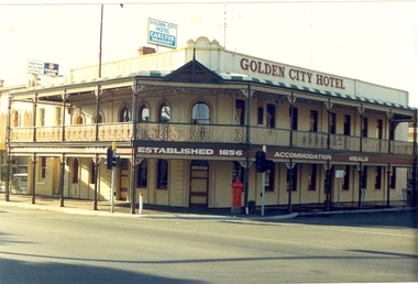 Federation University Historical Collection
Photograph - Photograph - Colour, Golden City Hotel, Ballarat
The Golden City Hotel was established in 1856. It was known as GeeCees in 2015.Photograph of a double storey hotel in Sturt Street Ballarat. The hotel features a verandah with cast iron work. A red pillar box is evident on the corner of Sturt Street and Dawson Street.golden city hotel, geecees, letter box, pillar box -
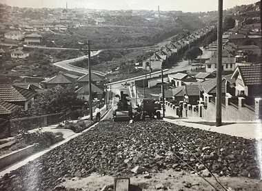 Kew Historical Society Inc
Photograph, City of Kew, Public Works, Road Construction, c. 1920s
An original photograph donated to the Kew Historical Society by the City's Engineering Department before the amalgamation of Kew into the City of Boroondara in 1994. While not all of the photographs are of Studley Park, Kew or East Kew, each photo provides a fine snapshot of the work of local government engineering departments of the period. They reveal they types of labour conducted, the techniques used and the equipment and machinery in the possession of the local government authority. Public works. A photograph of a suburban street under construction using a steamroller. The street was photographed to demonstrate the issues relating to grading. Neither the street nor the location has been identified. Inscription on reverse: "The construction of a roadway in a 1 in 3 1/2 grade. / The waggon is hauling the roller, by means of a cable attached to a pulley anchored at the top of the grade." engineering, city of kew (engineering department), road making construction -
Whitehorse Historical Society Inc.
Map, Municipality of Nunawading, c1950
Plan No 234, compiled and photo-lithographed at the Melbourne and Metropolitan Board of Works under the direction of G.R. McGowan, Chief Surveyor.Plan No 234, compiled and photo-lithographed at the Melbourne and Metropolitan Board of Works under the direction of G.R. McGowan, Chief Surveyor. Covers the area each Side of Canterbury Road from Orchard Grove to Vernon Street. Includes detail of creeks.Plan No 234, compiled and photo-lithographed at the Melbourne and Metropolitan Board of Works under the direction of G.R. McGowan, Chief Surveyor. blackburn south, gardiners creek, blackburn, blackburn creeklands -
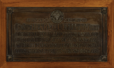 Kew Historical Society Inc
Plaque - Cr. Sir Henry de C. Kellett Bart, 1924
The plaque to Henry Kellett was originally mounted in the vestibule of the Kew Town Hall in Walpole StreetThe plaque was once part of the Municipal Collection of the former City of Kew and was presented to the Kew Historical Society before the move from the Walpole Street (Kew) Town Hall to new Civic offices in Charles Street in 1971.Bronze funeral plaque commemorating the life and death of Sir Henry de Castres Kellett, who was killed in a traffic accident in 1924. The plaque bears an extensive dedication and is mounted on a wooden mount that was previously attached to a wall in the Walpole Street [Kew] Town Hall ."City of Kew Victoria [logo] / Erected in Memory of / Cr. Sir Henry de C. Kellett Bart. / Accidentally Killed Whilst Engaged / On Municipal Duty 20th June 1924 / A Tribute to His Faithful Service as / Councillor for Forty Years 19884-1924"sir henry de castres kellett, mayors of kew (vic), councillors of kew (vic) -
 Kew Historical Society Inc
Plan, Melbourne & Metropolitan Board of Works : Borough of Kew : Detail Plan No.1585, 1904
The Melbourne and Metropolitan Board of Works (MMBW) plans were produced from the 1890s to the 1950s. They were crucial to the design and development of Melbourne's sewerage and drainage system. The plans, at a scale of 40 feet to 1 inch (1:480), provide a detailed historical record of Melbourne streetscapes and environmental features. Each plan covers one or two street blocks (roughly six streets), showing details of buildings, including garden layouts and ownership boundaries, and features such as laneways, drains, bridges, parks, municipal boundaries and other prominent landmarks as they existed at the time each plan was produced. (Source: State Library of Victoria)This plan forms part of a large group of MMBW plans and maps that was donated to the Society by the Mr Poulter, City Engineer of the City of Kew in 1989. Within this collection, thirty-five hand-coloured plans, backed with linen, are of statewide significance as they include annotations that provide details of construction materials used in buildings in the first decade of the 20th century as well as additional information about land ownership and usage. The copies in the Public Record Office Victoria and the State Library of Victoria are monochrome versions which do not denote building materials so that the maps in this collection are invaluable and unique tools for researchers and heritage consultants. A number of the plans are not held in the collection of the State Library of Victoria so they have the additional attribute of rarity.Original survey plan, issued by the MMBW to a contractor with responsibility for constructing sewers in the area identified on the plan within the Borough of Kew. The plan was at some stage hand-coloured, possibly by the contractor, but more likely by officers working in the Engineering Department of the Borough and later Town, then City of Kew. The hand-coloured sections of buildings on the plan were used to denote masonry or brick constructions (pink), weatherboard constructions (yellow), and public buildings (grey). This plan, which covers parts of High Street, Pakington Street and Derby Street is dominated by two historic Kew mansions: ‘Konetta’ and ‘Ramornie’. Ramornie was constructed in 1890 for James Maitland Campbell, three times Mayor of Kew. Sold in 1940, it became a boarding house known as ‘The Towers’. Now a private residence again, it has only one of its three balconies remaining. The location of the missing two balconies can be seen on the plan. In 1903, the grounds of Ramornie included a large tennis court fronting Pakington Street. The rear of the property is shown as extending to Cobden Street. One of Kew’s oldest hotels, the Prospect Hill Hotel on the corner of High and Cobden Street was established in 1858. The outline of the hotel shown on the plan represents the second building on the site. During the 19th century it was often used for electoral meetings. The Prospect Hill Hotel was to be redeveloped again in 1928, by the local architect Robert McIntyre. Since the 1980s, the hotel has been a live music venue, the home of the Melbourne Jazz Club, a restaurant and a liquor outlet.melbourne and metropolitan board of works, detail plans, maps - borough of kew, mmbw 1585, cartography -
 City of Kingston
Pamphlet - Colour, Roy Dunn Pty. Ltd, Central Corner Estate Moorabbin and Highett, c. 1923
Sales plan for land in the suburbs of Highett and Moorabbin, bordered by Point Nepean Road and Wickham Road East incorporating William StreetThe developing urban area of Highett and Moorabbin within the City of Kingston. This land sale pamphlet illustrates the subdivision of land within the municipality and the changing demographic of the district as new houses are constructed close to infrastructure.Colour pamphlet advertising for private sale land in the Central Corner Estate in Moorabbin and Highett. Incorporates a map of the estate bordered by Point Nepean Road and Wickham Road East, with subdivisions also available on both sides of William Street. Handwritten in blue pencil on subdivision plan: a tick is drawn on subdivisions 2-18 Handwritten in blue pencil on subdivision 6: a box with an x inside Handwritten in blue pencil on subdivisions 10 and 12: S Handwritten in black ink on front page: [indecipherable] / McKittricks Handwritten in grey pencil on rear page: McKilhick / Nepean Rd Handwritten in grey pencil on rear page upside down: 160000 / 15 8300 [crossed out] land sales, estate, highett, moorabbin -
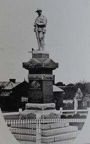 Stawell Historical Society Inc
Photograph, Soldiers’ Memorial World War 1 in Main Street -- Different angle
Soldiers’ Memorial WW1 Stawell. View looking towards corner of St George and Victoria Streets. Coffee Palace formerly Castlemaine Hotel behind. The photo is a copy of the original owned by Mrs. Joyce Ward.Black & white photograph of Soldiers Memorial WW1. The image is predominately of the Soldiers memorial and looking towards the corner of St. George & Victoria Streets. The left- and right-hand bottom corners of the photo are rounded.stawell ww1 ww2 -
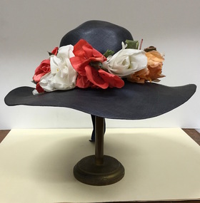 Kew Historical Society Inc
Headwear - Navy Straw & Silk Sun Hat, R & M Dower, 1949
R&M Dower was a major millinery partnership located at 146 High Street, Kew in the 1940s and 1950s. Examples of this millinery firm's hats are in other major public collections, including the National Gallery of Victoria.The Kew Historical Society’s fashion and design collection is comprised of costumes, hats, shoes and personal accessories. Many of these items were purchased or handmade in Victoria; some locally in Kew. The extensive hat collection comprises items dating from the 1860s to the 1970s. While most of the hats in the collection were created by milliners for women, there are a number of early and important men’s hats in the collection. The headwear collection is particularly significant in that it includes the work of notable Australian and international milliners.Wide brimmed navy blue fine straw woman’s hat retailed by R & M Dower of High Street, Kew, with red, white and apricot coloured fabric flowers surrounding the crown of the hat.Label: R & M Dower 146 High St., Kew. Phone WM 8527r & m dower, milliners, hats, australian fashion, women's clothing -
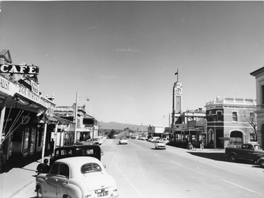 Stawell Historical Society Inc
Photograph, Main Street Stawell looking West towards the Town Hall, on the right c 1960's
Main Street Stawell looking West including Town Hall Shops and Motor Vehicles c 1960's. This photo was taken by M. Robson before being donated to the society. The photo of Main St. was taken before it was made into a Mall, now know as "Gold Reef Mall". The street reopened to traffic in 2005.Black & white photograph of Main St Stawell looking towards the Grampians. The view includes the Town Hall & Bank of Australia on the right, with shops either side and two vehicles travelling along the road with vehicles parked along the street c 1960's.stawell business streetscape -
 Ringwood and District Historical Society
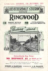
Flyer, Subdivisional Land Auction Sale Brochures, Heatherdale Station Estate, Ringwood, Vic. - 1923 and 1924
Two double sided multi-folded pages advertising public auction sales of shop sites and residential allotments on Saturday, 15th December, 1923 and Saturday, 2nd February, 1924, including summary of local facilities, services and map showing layout of the estate. Includes a photograph depicting proposed site for first Heatherdale railway station and a panoramic view of Ringwood from the railway level crossing in Heatherdale Road. 1923 and 1924 flyers are identical except for the auction dates printed at the top.Subdivision includes Heatherdale Road, Molan Street, Yallourn Parade, Newman Street, and Madden Street. Agents - Knight & Harwood, 315 Collins Street, Melbourne, Phone 10615, 10616 Central, in conjunction with J.B. McAlpin, Opposite Railway Station, Ringwood. Phone Ringwood 7. -
 Ringwood and District Historical Society
Flyer, Executor's Auction Subdivision Advertisement, Lilydale Road and Oban Road, Ringwood East, Vic. - 1937
Single page advertisement for Executor's Auction of land in Ringwood East on Saturday, May 29, 1937 with locality map showing 26 building sites for auction highlighted in brown, and brief summary of local services available. Subdivision includes Old Lilydale Road, Joseph Street, Dynes Street, Albert Street (later Wyrunga Street), Carcoola Road, and Mount Dandeong Road. (Carcoola Road incorrectly shown as Oban Road on the subdivision plan). Auctioneer - C.E. Carter, (Phone Ringwood 24. -
Port Fairy Historical Society Museum and Archives
Photograph, Mason, John
Captain John Mason came from Stirling in Scotland, arriving at Port Fairy in 1844. One year after James Atkinson obtained his Special Survey of the area. Thus his life covers all the history of Port Fairy when it was known as Belfast. He married Jane Murray in Portland in 1846 and they had 5 children, Jane died in 1855 and ten years later he married Ann Brown widow of Abijah Brown. They had no children and she died in 1887. In due course he became known as Captain Mason, he was not a sea captain, but captain of the Belfast Volunteers, a Rifle Corps formed in 1859 as a consequence of the Crimean War, and later reconstituted as the Belfast Volunteer Corps. For 40 years he displayed a remarkable versatility in his various occupations. Starting as an Innkeeper - he took over the Stag Inn from Captain Saunders in 1852, for 3 years. He then became a carpenter, stonemason, architect, estate agent honorary technical advisor to the Borough and treasurer to the Shire, and Savings Bank Secretary. They thought so well of John mason in Belfast that they elected him to the first Roads Board in 1853 and to the first Municipal Council in 1856. He was Chairman four times and with Councillors David Talbot and Joseph Whitehead designed the Council's Common Seal and the Motto "Commune Bonum".He was the first Mayor of the Borough in 1863 for a period of 7 weeks. He was responsible for the design, supervision or construction of many of the buildings in the town; most still standing today. He built the Rosebrook Bridge in 1855 and the first official Post Office ( a timber structure in Bank Street) in 1857, replacing it with a stone office in 1865. he built the Court house in 1859 and completed the breakwater between Rabbit Island and Griffith Island started by James Atkinson and John Griffith in 1849, also the first bridge over the Moyne river which connected with Battery Lane and the Bay. Among the many buildings associated with John Mason are Gobles Mill, Tynemouth Villa, 10-12 Princes Street, the Mechanics Institute, the Commercial Hotel, Yambuk and Mickey Bourke's Pub in Koroit. However, he did not build "Riverdale" in Gipps Street as is thought. He had a store and workshop on this site but sold the property in 1872 before the house was built. After an almost uninterrupted term as Councillor starting with the Municipality in 1856, John resigned from the Council in 1873. He well deserved the illuminated address they gave to him and the toast that they drank in the Bank Hotel champagne. Within the year he was working for the Borough as its engineer., surveyor, general supervisor and advisor of public works, simply as the man to whom all difficult problems were referred and at very little expense. John Mason was a great worker for his town and devoted himself unsparingly to the community. That his work was appreciated was shown by the way in which people rallied to his aid when, in the end, he found himself in financial difficulties and his reputation was challenge; arrested for embezzling from the Savings Bank of which he was the actuary in 1882. The money was repaid and the charges found not proven at his trial. He was an early member of the Loyal Prince Albert Lodge, and a founding member of the smaller Loyal Belfast Lodge in 1863. He was also a member of the Horticultural Society. Captain John Mason Died on the 14th of October 1891 (see also 62-04-046 photo)Sepia photograph on heavy cardStevenson & McNicoll photo. 108 Elizabeth Street Melbourne copies can be obtained at anytimedefence, captain, mason, carpenter, councillor, mayor -
 Lakes Entrance Regional Historical Society (operating as Lakes Entrance History Centre & Museum)
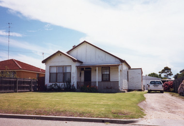
Photograph, 2000
House built on Rogby Island by Mitchelson around 1915, relocated to corner of Lake Street and Barkes Avenue around 1920, then to Phillips Street 1962. Front window altered, veranda frieze removed, side extension of veranda removed.Colour photograph of a timber residence at 3 Phillips Street. Gable roof, fibro cement section under gables. Front door has fanlight above, widow light beside door filled in. Barge board of gables typical of dwellings built by Leo Mitchelson, Lakes Entrance Victoriahouses, heritage study -
Port Melbourne Historical & Preservation Society
Photograph - 135 & 137 Evans Street (Raglan Street Housing Commission flats), Port Melbourne, Meredith Turnbull, Dec 1996
Meredith Turnbull photographed this series in 1996 to record the rapidly changing streetscape, which had already had a number of old houses replaced by concrete two-storey structures under the State government's urban consolidation policyFrom a series of 70 colour photos recording all buildings in Evans Street from Graham Street overpass to Ingles Street, as photographed from the railway reservation, by Meredith Turnbull in December 1996 - - number 135, 137- Raglan Street Housing Commission flatsHouse numbers noted on backbuilt environment - domestic, built environment - public housing, meredith turnbull -
 Eltham District Historical Society Inc
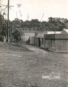
Photograph, N. J. Tillings Timber Factory, 15 June, 1975, 15/06/1975
N. J. Tillings Timber Factory was part of the Brougham Street, Light industrial area, Eltham. Brick bulidings includes signage: Wakefield Pr... (printer?) No 17 Building C. This is one of 7 B/W 8x10 inch photos with notes on obverse by Dick Crichton. Accompanying letter from Florence Chrichton 2013 : "Originally sent to Shire of Eltham Engineer, Mr. McDonald. [These photographs were part of their campaign to the Shire of Eltham in 1975] claiming that the zoning regulations were being breached by the occupants of various factories in the nearby light industrial zone [Brougham Street, Eltham] - to the detriment of those living in adjoining residential zones, and that, despite .. earlier objections and complaints, nothing was done about it."1 black and white photograph printed with white borderInscribed on back: "Weekend photograph of factories in Brougham Street surrounded by by residential zone. On weekdays cars surround premises - these have been built approx. two years - where is the landscaping? * Undeveloped light industrial land. Careful planning needed for future. Being on high elevations backs of future buildings will be seen from Main Road Eltham and future Art Centre complex. Also Bolton Street becoming heavily used arterial road. Off street parking facilities most important." . The front of the photo has pen marks indicating points of interest.industrial estate, brougham street, eltham -
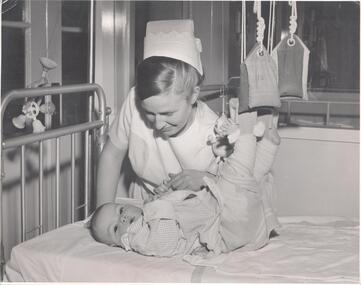 Northern District School of Nursing. Managed by Bendigo Historical Society Inc.
Photograph - School 71 - Nurse caring for child
The Northern District School of Nursing opened in 1950 in to address the issues around nurse recruitment, training and education that had previously been hospital based. The residential school was to provide theoretical and in-house education and practical training over three years. The students would also receive practical hands-on training in the wards of associated hospitals. The Northern District School of Nursing operated from Lister House, Rowan Street, Bendigo. It was the first independent school of nursing in Victoria and continued until it closed in 1989.Nurse Margaret Eva Jacka School 71 (PTS 31/7/72) holding the fingers of a child in traction in hospital bedNDSN Please return to J O'Shea Small Photo - Leo A Hughes Photographer 7 High Street Eaglehawk 3556ndns, nursing training, nursing education equipment -
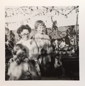 Kew Historical Society Inc
Photograph - 'Fairyland', 57 Malmsbury Street, 1960-65
'Fairyland' at 57 Malmsbury Street, Kew - the home and garden of Jim and Grace Tabulo - was a major local, state and international tourist attraction from the 1940s to the mid 1960s. The Kew Historical Society's collection contains original photographs, visitor books and items that were once displayed in the house by the Tabulos. Grace Tabulo died in 1973 and is buried with her husband Jim in the Boroondara General Cemetery (PRES B 1973). Following her death at the age of 88, the house was sold and its contents distributed. The cottage is now a private residence. The 'Fairyland' collection is of local and statewide significance, as a varied and comprehensive record of this major Melbourne tourist attraction. Original, small, black and white photographic positive, of a woman and two children in the rear garden of 'Fairyland', at 57 Malmsbury Street, Kew.fairyland, 57 malmsbury street -- kew (vic.), grace tabulo, jim tabulo -
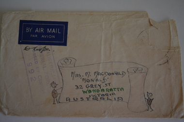 Wangaratta RSL Sub Branch
Envelope Art
Sent to Mrs MacDonald "Monald" 32 Grey Street Wangaratta by soldier during second world war.Victoria's 2/24th Infantry Battalion was raised in Wangaratta in July 1940. They were welcomed with open arms by the local community as they rapidly built up their numbers. The people of Wangaratta adopted the Battalion and they became known as "Wangaratta's Own" because of the time the battalion spent in the town during its formative period prior to deployment overseas. Many of the soldiers maintained life long friendships with the people of Wangaratta. Even though the Battation was disbanded in 1946 members and their families return each year, in November, for a commemorative service at the 2/24th Battalion Memorial Wall at the Wangaratta Cemetery.Cream paper envelope with hand drawn scroll with stick figure either side Top left - AIR MAIL Top right - postage stamp Left side - AIF Censor stamp Right side Mrs M MacDonald "Monald" 32 Grey Street Wangaratta Victoria Australiaww2, envelope art -
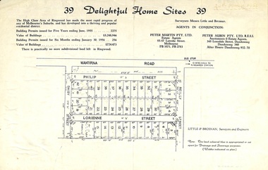 Ringwood and District Historical Society
Flyer, Subdivision advertisement for sale of home sites - Ringwood, Victoria - 1956
Cardboard-backed advertisement for 39 home sites for sale, with location map, and summary of local real estate statistics in 1955 & 1956. Handwritten date noted in top right corner - 24th March, 1956.Subdivision map includes Reilly Street, Philip Street, Lorienne Street and Daisy Street in Heathmont. Surveyors: Messrs Little and Brosnan. Agents in conjunction: Peter Martin Pty. Ltd., Estate Agents, 55-57 Latrobe Street, Melbourne (Phone) FB 3571, FB 2783, and Peter Aubin Pty. Ltd., Auctioneers & Estage Agents, 345 Lonsdale Street, Dandenong (Phone) Dandenong 340, after hours Dandenong 932, 70. -
 Orbost & District Historical Society
printer's block, 1920's
This printer's block was used by the Snowy River Mail in the 1920's. This block is an advertisement for Tomlinson and McFarlane Bros, Drapers and General Merchants of Nicholson Street, Orbost.Since 1890 the Snowy River Mail has been the local newspaper of the Orbost district.This local paper has been the means by which readers in Orbost were able to learn about newsworthy events and issues in their local community for over a century.A printer's block from the Snowy River Mail. It is an advertisement for ladies' wear in the 1920's. It is an ad for Tomlinson and McFarlane Bros.of Nicholson Street Orbost and advertises fashionable contour corsets. The plate is nailed onto a block of chipboard.printing newspaper media advertisement tomlinson-and-mcfarlane-bros -
 Federation University Historical Collection
Photograph, St Patrick's Cathedral Presbytery, Ballarat, 2020, 13/04/2020
Colour photograph of a former corner store in Lyons Street South, Ballarat, near the intersection of Sebastopol Street.ballarat, lyons street south, architecture -
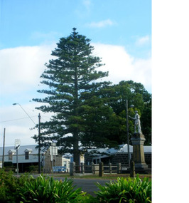 Mortlake and District Historical Society
The Peace Tree
This Norfolk Island pine tree was planted in 1919 as 'The Peace Tree'. A community gesture signifying the embrace of 'peace' as a valuable concept symbolised by the planting of a tree. [from Mortlake Dispatch] PEACE DAY 1919. Throughout the Empire three days were marked as Public Holidays including Peace Day in July 1919. Mortlake observed Peace Day by Peace Medals being distributed at the State School, Union Jacks being flown from many buildings and houses and the Peace Tree being planted at the intersection of Officer Street, Jamieson Avenue and Shaw Street. Then followed a procession [of local people]. It is assumed the Progress Association, which undertook the Avenue of Honour, also was responsible for planting the Peace Tree. Norfolk Pine tree located on eastern corner of Officer Street, Shaw Street and Jamieson Avenue intersection.1919, peace, norfolk island pine