Showing 1406 items
matching bushfire
-
 Ballarat Heritage Services
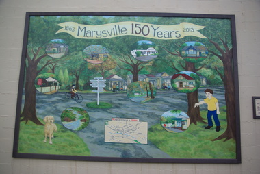
Photograph - Colour, Clare Gervasoni, Marysville Mural, 2014, 01/11/2014
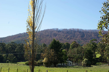
Colour photograph of the Marysville Mural by Russell Danby.Marysville Mural This mural is dedicated to the people of Marysville past, present and future. May it invoke ling held enjoyable memories for residents and visitors, through it's (sic) showcasing of someof Marysville's buildingsand iconic scenery prior to 'Black Saturday' bushfires 2009 Interpreted and painter by muralmaker - Russell Danby Giften by an anonymour benefactorbushfire, black saturday, marysville, marysville mural, russell danby -
 Forests Commission Retired Personnel Association (FCRPA)
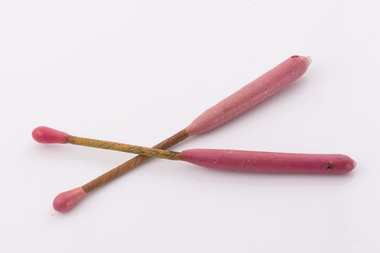
Delayed Action Incendiary Device (DAID), Bryant and May - Richmond, Large double ended match
The Forests Commission developed the use of helicopters for aerial ignition from the mid 1960s. Bryant and May at Richmond worked with the Commission to develop a Delayed Action Incendiary Device. DAIDs as the were known, had an overall length of 180 mm, striker end length - 10 mm. Ignition end length - 80 mm, then a layer of high melting point wax (to prevent accidental ignition when rubbing together in transit). Both ends coated with a modified match head compound with safety fuse exposed length between coated match ends. There was a 17-second delay from when the small end was struck to an intense flaming of the large end, which lasted for 40 seconds. DAIDs were dangerous so were stored in a metal box outside the helicopter along with a disposable striker patch attached with a quick release pin to a special half-door. The first test was with a Bell 47G on 4 October 1967 and the first use, anywhere in the world, of DAIDs to backburn a large bushfire was undertaken in north eastern Victoria in February 1968. There was a crash of an FCV helicopter conducting aerial ignition near Wandiligong on 19 April 1978 with the tragic death of two forest officers and their pilot. The crash led to the immediate end of the use of DAIDs and the adoption of the safer Premo ping-pong ball incendiary machine which originally came from Canada but was modified at the Altona workshops. Overall, the development of aerial ignition techniques by the Forests Commission from the mid-1960s resulted in a steady climb in the area burnt each year…. peaking at 477,000 ha in 1980-81 and with an impressive 10-year rolling average of 220,000 ha around the time of 1983 Ash Wednesday Bushfires.Developed in Victoria for aerial ignitionLarge double ended match used for aerial ignition and back burning by dropping from a helicopterbushfire, forests commission victoria (fcv) -
 Mt Dandenong & District Historical Society Inc.
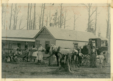
Photograph, 'Callum House' - Bill Farndon's Guest House 1911, 1911
Front view of Callum House located on the corner of Falls and Farndons Roads. Built by Bill Farndon. In the background are trees killed by bushfires in 1897. There is a horse and buggy in the foreground. Figures standing have been identified as (from LHS) Jim Clarke, Len Farndon, Jack Clarke, Essie Farndon, Rhoda farndon, Doug Farndon, Mrs Farndon. Driver is Bill Campbell. This photograph has a detailed inscription on the back handwritten by John Lundy-Clarke in 1974.1911 “Callum House” Farndon’s guest house corner of Fall’s and Farndon’s Roads. Later “Bonvenu” and again “The Oaks”. Showing the trees killed by bushfires in 1897. Figures standing are from left – Jim Clarke, Len Farndon, Jack Clarke, Essie Farndon, Rhoda Farndon, Doug Farndon, Mrs. Farndon. Bill Campbell driving.callum house, benvenu, the oaks, essie farndon, bill farndon, rhoda farndon, bill campbell, jim clarke, jack clarke, doug farndon -
 Victorian Interpretive Projects Inc.
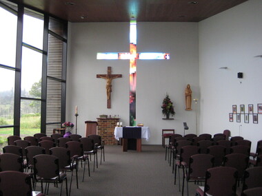
Photograph - Digital, Clare Kathleen Gervasoni, St Mary's Kinglake, 2012, 15/12/2012
The images depict the newly completed fourth Catholic Church at Kinglake. The previous three churches having been destroyed by 'Black Saturday' bushfire. The painting is oil on canvas. The historical continuity is expressed by the continuity of the skyline and the disconnectedness of the colours. it is not a literal depiction of each church, but a recognizable and symbolic image conveying resilience of faith of the local community. The first church was burnt down in a bushfire, the second burnt down by vandals, and the three burnt down in the 2009 bushfires known as 'Black Saturday'.The white cross and black fence at the lower left commemorated the remarkable fact that these remained intact after the 2009 bushfires. The red-orange can be the colour of the kinglake soil or the fires. The return of new life is indicated by the green growth on the burnt gumtrees. The presence of the Holy Trinity is shown above the entrance to the church. The return of new life is indicated by the green growth on the burnt gumtrees. The presence of the Holy Trinity is shown above the entrance to the church. The Holy Sprit is symbolized by the sulphur crested cockatoo, an Australian bird instead of the white dove. The symbol for the father is above the church in the triangle which has God's Holy Name (I AM) as given to Moses from the Burning Bush, written in Hebrew. Christ is represented by the cross above the entrance. The previous church was destroyed in the 2009 bushfires. The area is surrounded by 22,000 hectares of Kinglake National Park, the largest National Park close to Melbourne. The park was established in 1928 to protect native flora and fauna. Kinglake takes its name from Alexander Kinglake who travelled through the area in 1870. Photographs showing the newly built St Mary's Catholic Church at Kinglake. .1) Interior of Church .2) Painting of the Four Churches of Kinglake by Judy Racz .3-5) Views from the Church windows to the adjoining landscape .6) St Mary's Church groundskinglake, bushfire, black saturday, church, catholic, racz, st mary's catholic church kinglake -
 Forests Commission Retired Personnel Association (FCRPA)
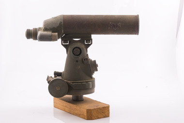
Telescope used in FCV fire towers - ex military, c 1940s
Victoria once had well over one hundred fire lookouts and firetowers. Fire lookouts, or observation posts, were often just a clearing on a hill or a vantage point, whereas firetowers were definite structures. Many were established by the Forests Commission Victoria (FCV) in the 1920s, but the network was expanded rapidly in response to recommendations of the Stretton Royal Commission after the 1939 Black Friday bushfires. When a fire or smoke was spotted from the tower a bearing was taken with the alidade and radioed or telephoned into the district office. It was then cross referenced with bearings from other towers on a large wall map to give a "fix" on the fire location Alidades and telescopes were used in the post war period but were replaced with a much simpler map table and reference string suspended from the centre of the tower cabin.Uncommon usageTelescope used in fire towers Ex military Kern Company NY Argus made in USA Adjustment lens, dials and focus ring Small spirit levelbushfire, forests commission victoria (fcv) -
 Forests Commission Retired Personnel Association (FCRPA)
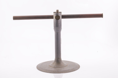
Alidade - sight tube used in FCV fire towers, c 1940s
Victoria once had well over one hundred fire lookouts and firetowers. Fire lookouts, or observation posts, were often just a clearing on a hill or a vantage point, whereas firetowers were definite structures. Many were established by the Forests Commission Victoria (FCV) in the 1920s, but the network was expanded rapidly in response to recommendations of the Stretton Royal Commission after the 1939 Black Friday bushfires. When a fire or smoke was spotted from the tower a bearing was taken with the alidade and radioed or telephoned into the district office. It was then cross referenced with bearings from other towers on a large wall map to give a "fix" on the fire location Alidades and telescopes were used in the post war period but were replaced with a much simpler map table and reference string suspended from the centre of the tower cabin.Uncommon usageAlidade Sight TubeFCV and bearing markers on the alloy base. Very simple design. bushfire, forests commission victoria (fcv) -
 Ringwood and District Historical Society
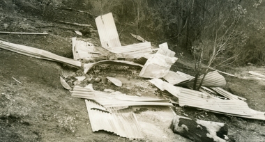
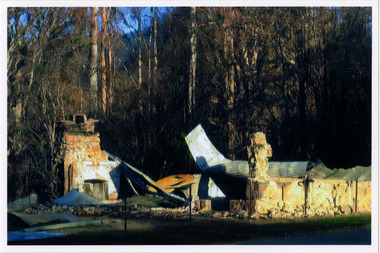
Remnants of Burnt Buildings after 1939 Bushfires, Warranwood - Aftermath of 1939 bushfires showing remains of burnt out building, 1939
Two photographs of the aftermath of the 1939 bushfires in Warranwood. They show the remains of a burnt-out building. +Additional Keywords: Purser1939 Mrs Purser 23/10/84 Please Return -
 Marysville & District Historical Society
Photograph (Item) - Colour photograph, 02-2009
A colour photograph of The Log Cabin in Marysville in Victoria.A colour photograph of The Log Cabin in Marysville in Victoria. The Log Cabin was built by Thomas Henry Branchflower who had arrived from England late in 1921. It was built for Gwendoline Pitman after the death of her father Clarence Pitman and the disappearance of her sister Olive in July 1926. Gwendoline operated an artist and souvenir shop in the newly built Log Cabin in partnership with Peter Mackey who was a Melbourne optician and artist. The Log Cabin, along with most of the buildings in Marysville, was destroyed in the 2009 Black Saturday bushfires.Log Cabin/ Marysville/ Feb 2009the log cabin, marysville, victoria, thomas henry branchflower, gerald branchflower, mary chain, gwendoline pitman, clarence pitman, kooringa guesthouse, olive pitman, wilbur anderson, peter mackey, photograph, 2009, 2009 black saturday bushfires -
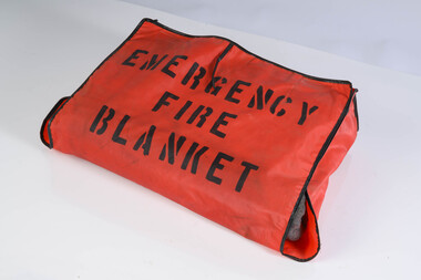 Department of Energy, Environment and Climate Action
Fire safety blanket
Carried in all vehiclesWoollen safety blanket carried in all departmental vehicles in case of being trapped in a bushfire Vinyl carry bagEmergency fire blanketforests commission victoria (fcv), safety equipment -
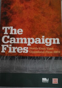 Wodonga & District Historical Society Inc
Book - The Campaign Fires - North-East/East Gippsland Fires 2003, Lyndel Hunter, 2003
A description of efforts to fight the bushfires in Gippsland in 2003, including maps and illustrations This volume was published as a tribute to the work of staff and volunteers who put themselves at risk to protect local communities. It shows the impact on those communities in Victoria and the support they gave to those involved in fighting largest bushfires in Victoria for 60 years. The Alpine bushfires started on 8 January 2003, a day of Total Fire Ban. Lightning ignited 87 fires in the North-East and East Gippsland regions. Eight of these fires were unable to be contained; they joined together to form the largest fire in Victoria since the Black Friday fires in 1939. The majority of the area burnt in Victoria was public land, 1.19 million hectares of parks and forests, including 60 per cent of the Alpine National Park and 81 per cent of the Mt Buffalo National Park. Firefighting efforts were made difficult in hard to access, remote forest terrain. Approximately 90,000 hectares of private land was burnt.This publication of 119 pages features text, colour images, maps and detailed information related to the 2003 bushfires in Victoria.non-fictionA description of efforts to fight the bushfires in Gippsland in 2003, including maps and illustrations This volume was published as a tribute to the work of staff and volunteers who put themselves at risk to protect local communities. It shows the impact on those communities in Victoria and the support they gave to those involved in fighting largest bushfires in Victoria for 60 years. The Alpine bushfires started on 8 January 2003, a day of Total Fire Ban. Lightning ignited 87 fires in the North-East and East Gippsland regions. Eight of these fires were unable to be contained; they joined together to form the largest fire in Victoria since the Black Friday fires in 1939. The majority of the area burnt in Victoria was public land, 1.19 million hectares of parks and forests, including 60 per cent of the Alpine National Park and 81 per cent of the Mt Buffalo National Park. Firefighting efforts were made difficult in hard to access, remote forest terrain. Approximately 90,000 hectares of private land was burnt.forest fires -- victoria, bushfires, fires prevention and control -
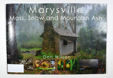
 Marysville & District Historical Society
Book, Marysville-Moss, Snow and Mountain Ash
A pictorial book of the flora, fauna and waterfalls in the Marysville district affected by the 2009 Black Saturday bushfirePaperback. Front cover has a main photograph of Keppel's Hut on a misty day in the rainforest. There are also four small photographs along the lower edge of the front cover. They are of a Mountain Ash canopy, a Drosera Peltata, a Brown Tree Frog and a view of the smoke plume on Black Saturday.marysville, victoria, australia, landmarks, flora, fauna, waterfalls, black saturday, bushfire, nature -
 Marysville & District Historical Society
Book, Marysville-Moss, Snow and Mountain Ash, Unknown
A pictorial book of the flora, fauna and waterfalls in the Marysville district affected by the 2009 Black Saturday bushfirePaperback. Front cover has a main photograph of Keppel's Hut on a misty day in the rainforest. There are also four small photographs along the lower edge of the front cover. They are of a Mountain Ash canopy, a Drosera Peltata, a Brown Tree Frog and a view of the smoke plume on Black Saturday.marysville, victoria, australia, landmarks, flora, fauna, waterfalls, black saturday, bushfire, nature -
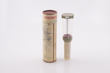 Forests Commission Retired Personnel Association (FCRPA)
Ventimeter, Wind anemometer in cardboard tube
Bushfire behaviour is influenced by many factors including temperature, relative humidity (RH), forest type, fuel quantity and fuel dryness, topography and even slope. But wind has a dominant effect on the Rate of Spread (ROS), as well as fire size, shape and direction. Wind speed can be measured using a variety of anemometers. This simple hand-held Venitimer was made by Elvometer in Sweeden, probably in the 1960s, and was designed for principally for mariners. Some models have a compass in the handle to measure wind direction. The small inlet hole on the side is faced towards the wind and air pressure lifts small plastic disk inside. The upper tube is tapered so that as wind speed increases more air escapes and stronger winds are needed to raise the disk. Wind speed in MPH is read from the side of the clear plastic tube. The waterproof container has instructions on use and conversion scales. Simple and robust device.Hand- held wind anemometer Instructions on use on containerbushfire, forests commission victoria (fcv) -
 Forests Commission Retired Personnel Association (FCRPA)
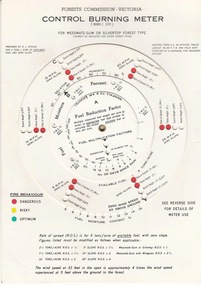
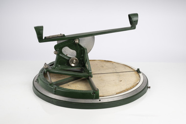
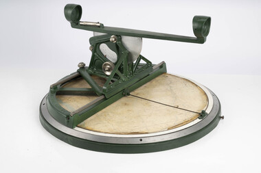
FCV Control burning meter, 1970
The Forest Fire Danger Index (FFDI) was originally invented by the grandfather of Australian bushfire science, Alan Grant McArthur, during the 1950s and ‘60s. Alan published his landmark paper, “Controlled burning in eucalypt forests” in 1962. Leaflet No. 80, as it was known, proved a turning point for forest and fire managers across Australia. More importantly, Alan was very practical forester and wanted his work to be useful to people in the field, so after several iterations he came up with the now familiar circular slide rule called the Forest Fire Danger Meter (FFDM). The Mk 4 version first appeared in operational use in 1967. Two Forests Commission staff, Athol Hodgson and Rus Ritchie, built on McArthur’s pioneering work and by applying their own practical experience, developed a modified version in the late 1960s called the Control Burning Meter which was better suited to Victorian forest conditions.Introduced to the FCV in 1970Control burning meterbushfire, forests commission victoria (fcv) -
 Department of Energy, Environment and Climate Action
Fire Finder
Victoria once had well over one hundred fire lookouts and firetowers. Fire lookouts, or observation posts, were often just a clearing on a hill or a vantage point, whereas firetowers were definite structures. Many were established by the Forests Commission Victoria (FCV) in the 1920s, but the network was expanded rapidly in response to recommendations of the Stretton Royal Commission after the 1939 Black Friday bushfires. When a fire or smoke was spotted from the tower a bearing was taken with the alidade and radioed or telephoned into the district office. It was then cross referenced with bearings from other towers on a large wall map to give a "fix" on the fire location. Alidades and telescopes were used in the post war period but were replaced with a much simpler map table and reference string suspended from the centre of the tower cabin. This "Fire Finder" was used in Canadian fire towers to identify the location of wildfires. The unique design was first developed by the British Columbia Forest Service (BCFS) in the early 1950s. Close examination of the map indicates that this particular Fire Finder may have been once used at Bluejoint Mountain lookout in Granby Provincial Park. This Fire Finder was a gift to Barry (Rocky) Marsden from the British Columbia Forest Service in the late 1980s in recognition of the close relationships that had been forged with the staff at the Altona Workshops over many decades. Fire Finders were originally painted black but this one was repainted green after it arrived at Altona. The BC Forest Service had a large facility where they manufactured Fire Finders and many other items of equipment, but in the 1980s it was shut down. Heavy cast iron circular object with a paper topographic map mounted on it. The metal dial and ruler works similar to a compass. The sight tube is used to determine the bearing and elevation of the fire on the map. This Fire Finder also sometimes known as an Alidade. Its a different design from the Osborne Fire Finder widely used in North American fire lookouts from the 1920s. British Columbia Forest Service. Model 62A. Serial Number 6308.bushfire -
 Forests Commission Retired Personnel Association (FCRPA)
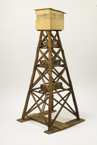
Wooden Model Fire Tower, Tom Coish, Model of Reef Hills fire tower, (5 km south of Benalla), 1957
Victoria once had well over one hundred fire lookouts and firetowers. Fire lookouts, or observation posts, were often just a clearing on a hill or a vantage point, whereas firetowers were definite structures. There are at least three categories of firetowers… (1) tree perches, (2) four-legged towers made of either wood or steel, as well as (3) hilltop cabins and observatories. Many were established by the Forests Commission Victoria (FCV) in the 1920s, but the network was expanded rapidly in response to recommendations of the Stretton Royal Commission after the 1939 Black Friday bushfires. The wooden towers were often built by bush craftsmen like legendary FCV overseer Clem Heather from Orbost. But advances in aerial reconnaissance and radio technology led to the gradual reduction in the number of fixed towers. FFMV now operates 72 firetowers. The CFA, Melbourne Water, Hancock Victorian Plantations (HVP) also operate some, the Army has one at Puckapunyal overlooking the live-firing range. Only two remaining fire towers of this design remain in Victoria (Mt Little Dick and Big Tower in the Mullungdung State Forest). Mt Nowa Nowa and Stringers Knob burnt down in the 2019/20 bushfiresLarge model of an Reef Hills fire tower. Presumably used for instructional purposes. Traditional FCV four legged design with three landings and closed cabin.bushfire, forests commission victoria (fcv) -
 Marysville & District Historical Society
Photograph (Item) - Colour photograph, 2009
A digital copy of a colour photograph of a house on the Marysville-Buxton Road near Marysville in Victoria.A digital copy of a colour photograph of a house on the Marysville-Buxton Road near Marysville in Victoria.marysville-buxton road, marysville, buxton, victoria, photograph -
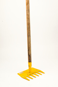 Forests Commission Retired Personnel Association (FCRPA)
Rakehoe, McLeod Tool (American)
Bushfire perimeter rather than bushfire area is the main control problem for firefighters on the ground. A conundrum rapidly compounded by spot fires. A small 5 ha fire can be nearly 1 km around the perimeter. That's a long way to build a control line by hand in rough bush. Dry firefighting techniques by hand were mostly confined to “knocking down” or “beating out” the flames, as well as "digging out". Digging or raking a “mineral earth” trail down to bare dirt proved most effective in forest fuels which, unlike grass, tend to retain heat and smoulder. Early tools were whatever happened to be close at hand. They were simple and primitive and included shovels, slashers, axes, hoes, beaters and rakes. A cut branch to beat the flames was often the only thing available. Farming and logging tools, developed over centuries of manual labour, and readily available at local hardware stores came into use, but little thought was given to size, weight, and balance. For years foresters experimented with combination tools. In about 1952 fire beaters and other implements were being replaced with Rakuts. However, its believed the now common Rakehoe is an Australian variation of the American McLeod Tool which was developed in 1905 by forest ranger Malcolm McLeod of the Sierra National Forest. The late Athol Hodgson advised that predecessors, Reg Torbet who had been the Chief Fire Officer for the Forests Commission from 1948-1956, along with his QLD counterpart Clive Price, went in late 1951 as Australian delegates on a 10 week fire study tour of Nth America organised by the United Nations. They came back with a couple of McLeod tools from Canada. Cam MacLeod (different spelling) had been the Head of Fire Research for the Canadian Forest Service at the time and had supplied them. The tools were ideal for deciduous forests in the eastern provinces and Clive arranged to have them manufactured in QLD. The Rakho, as it was then spelled, was first issued to FCV crews 65 years ago in 1955-56. The American Pulaski had been trialled, but never found favour with Australian firefighters.First used in 1955Rakehoe Combination of a heavy-duty six-toothed (each 9cm long) rake with a large, sturdy (25cm) hoe.bushfire, forests commission victoria (fcv) -
 Department of Energy, Environment and Climate Action
Delayed Action Incendiary Device (DAID)
The Forests Commission developed the use of helicopters for aerial ignition from the mid 1960s. Bryant and May at Richmond worked with the Commission to develop a Delayed Action Incendiary Device. DAIDs as the were known, had an overall length of 180 mm, striker end length - 10 mm. Ignition end length - 80 mm, then a layer of high melting point wax (to prevent accidental ignition when rubbing together in transit). Both ends coated with a modified match head compound with safety fuse exposed length between coated match ends. There was a 17-second delay from when the small end was struck to an intense flaming of the large end, which lasted for 40 seconds. DAIDs were dangerous so were stored in a metal box outside the helicopter along with a disposable striker patch attached with a quick release pin to a special half-door. The first test was with a Bell 47G on 4 October 1967 and the first use, anywhere in the world, of DAIDs to backburn a large bushfire was undertaken in north eastern Victoria in February 1968. There was a crash of an FCV helicopter conducting aerial ignition near Wandiligong on 19 April 1978 with the tragic death of two forest officers and their pilot. The crash led to the immediate end of the use of DAIDs and the adoption of the safer Premo ping-pong ball incendiary machine which originally came from Canada but was modified at the Altona workshops. Overall, the development of aerial ignition techniques by the Forests Commission from the mid-1960s resulted in a steady climb in the area burnt each year…. peaking at 477,000 ha in 1980-81 and with an impressive 10-year rolling average of 220,000 ha around the time of 1983 Ash Wednesday Bushfires.Developed in Victoria for aerial ignition by the FCV and Byant & MayLarge double ended match used for aerial ignition and back burning by dropping from a helicopterforests commission victoria (fcv), bushfire, planned burning -
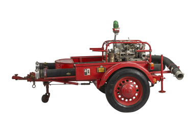 Department of Energy, Environment and Climate Action
Coventry Climax Pump - modified with recoil start
Among the many pressing priorities for Alf Lawrence, the Forests Commission's new Chief Fire Officer, in rebuilding the firefighting capacity after the catastrophic 1939 bushfires was to invest heavily in modern vehicles and equipment. Powered pumps like the trailer-mounted Coventry Climax (Godiva) gave firefighters a much greater capacity than ever before to put the “wet stuff on the red stuff”. Its four-cylinder, four-stroke, water-cooled, petrol motor produced 38Hp and was connected with either 1½ inch or 2½ inch canvas hose for direct attack, or as a filler pump it could deliver 300 gallons per minute at 120 psi. Some of the first acquisitions included this war surplus veteran shipped over from the London after the blitz bombings of WW2. Fire pump mounted on trailer Two lengths of suction hose, nozzles and some tools. Modified from original design at Altona to include recoil battery starterCoventry Climax fire pump, forests commission victoria (fcv), bushfire -
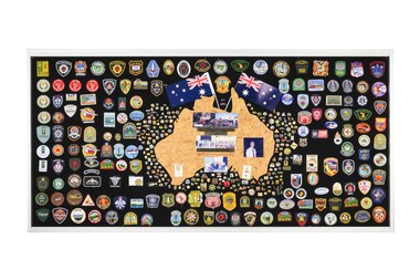 Department of Energy, Environment and Climate Action
Display board
The Forests Commission and its successors continuously encouraged bushfire research and innovation. In 1946 a large parcel of industrial land was purchased at North Altona as a fire cache and workshop. The Altona workshop became a hotbed of new technological innovation… an exhilarating place where lots of things were invented and tested. In fact, a lot of Australia’s pioneering equipment development was led by staff from Altona, often in collaboration with other State forestry and fire authorities. The CSIRO also contributed significantly. The US Forest Service, the US Bureau of Land Management and US State agencies such as the California Department of Forestry and Fire (CalFire) as well as the Canadian Forest Service faced similar challenges and proved strong and willing partners in sharing knowledge, ideas, equipment and expertise over many decades. This collection of badges is testament to the relationships that were forged across the globe with the Altona workshop. Large display panel featuring many fire service badgesforests commission victoria (fcv), bushfire, bushfire aviation -
 Southern Sherbrooke Historical Society Inc.
Book - Local History, Sassafras-Ferny Creek Fire Brigade, Hills Of Fire, 1992
pp viii, 76; 6 appendices & bibliography, footnotes, 1 map, photographs. A history of bushfires in the Dandenong Ranges and the Sassafras-Ferny Creek CFA Brigade.sassafras-ferny creek fire brigade, dandenong ranges, bushfires -
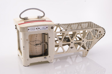 Forests Commission Retired Personnel Association (FCRPA)
Thermo-hygrograph
Bushfire behaviour is influenced by many factors including temperature, relative humidity (RH), forest type, fuel quantity and fuel dryness, topography and even slope. Wind has a dominant effect on the Rate of Spread (ROS), as well as fire size, shape and direction. Temperature and relative humidity have major impacts on fuel dryness and therefore upon the availability of fuel for combustion. A thermo-hygrograph measures and records both temperature and humidity. It produces a continuous record by drawing ink traces on a paper chart held in revolving cylinder. Humidity is measured by shortening or lengthening of a bundle of specially treated human hair. Temperature is measured by means of a laminated bi-metal strip of temperature-sensitive metals which bend differentially with temperature change. The recording drum is driven by clockwork which may be geared for rotation intervals of daily, weekly or monthly periods. This particular instrument is a seven-day recorder. Serial number 10186 which probably dates from about 1960. The chart indicates it was last used in March 1979.Used for bushfire research.Clockwork Thermo-hygrographCasella London 10186 Made in England Research Branch. Forests Commission Orbostbushfire, forests commission victoria (fcv), forest measurement -
 Forests Commission Retired Personnel Association (FCRPA)
Sling Psychrometer
Bushfire behaviour is influenced by many factors including temperature, relative humidity (RH), forest type, fuel quantity and fuel dryness, topography and even slope. Wind has a dominant effect on the Rate of Spread (ROS), as well as fire size, shape and direction. Temperature and relative humidity have major impacts on fuel dryness and therefore upon the availability of fuel for combustion. The amount of fine fuel available can increase rapidly from nearly zero when fuel moisture content is more than 16% after rain or a heavy morning dew, to many tonnes per hectare as fuel dries out later in the day and the moisture content drops below 9%. This explosive escalation in the amount of available fuel can happen over a few hours on hot and windy days. A sling psychrometer is a simple device for determining air temperature and relative humidity. It contains two thermometers, one of which is covered with a wick saturated with ambient temperature liquid water. These two thermometers are called dry bulb and wet bulb. When the sling psychrometer is spun rapidly in the air, the evaporation of the water from the wick causes the wet bulb thermometer to read lower than the dry bulb thermometer. After the psychrometer has been spun long enough for the thermometers to reach equilibrium temperatures, the unit is stopped, and the two thermometers are quickly read. A psychrometric scale on the side of the instrument is then used to convert the dry bulb temperature TDB and the wet bulb temperature TWB into humidity information. The wet bulb temperature is approximately equal to the adiabatic saturation temperature. The thermometers fold back into the plastic handle when not in use. Used to measure temperature and relative humiditySling PsychrometerBACHARACH INSTRUMENTS - Pittsburg PAbushfire, forests commission victoria (fcv) -
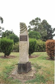 Linton and District Historical Society Inc
Photograph, Memorial to Firefighters, Linton
The memorial was erected in August 2000, and the design represents an eternal flame.Colour photograph of the memorial on the Glenelg Highway at the Ballarat-end entrance to Linton. The monument commemorates the five firefighters who died in a bushfire near Linton in December 1998.memorials, monuments, firefighters, cfa volunteers, linton bushfire 1998 -
 Clunes Museum
Photograph, HOSPITAL
LAMINATED BLACK AND WHITE PHOTOGRAPH OF OLD CLUNES HOSPITAL. AT CRESWICK ROAD CLUNES BUILD 1873 DESTROYED IN BUSHFIRE IN 1944. STAFF AND VISITORS STANDING IN FRONT OF HOSPITAL.local history, photography, photographs, hospital [old], wood chop -
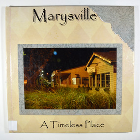 Marysville & District Historical Society
Book - Hardback, Marysville-A Timeless Place
A pictorial journey of Marysville before the 2009 Black Saturday bushfireA book of photographs taken in and around Marysville before the 2009 Black Saturday bushfires. Marysville was almost completely destroyed in the fire and this book showcases natural attractions, locations to eat and stay and some of the local flora and fauna in and around the district.Hardcover. Front cover has a photograph of the Corner Cupboard Cafe in Marysville taken at night.In memory of those that lost their lives and property in the/ Black Saturday fires/ on the 7TH of G=February 2009marysville, photographs, victoria, australia, black saturday, bushfire, 2009, 7th february 2009, angelina lodge, darmody lake, galipolli park, murchison street, meeting of the waters, marysville bakery, marysville patisserie, lolly shop, bruno's sculpture garden, crystal journey, flora, fauna, coralyn falls, steavenson falls, keppel lookout -
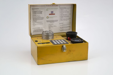 Department of Energy, Environment and Climate Action
Prototype fuel moisture meter
Bushfire behaviour is influenced by many things including temperature, relative humidity, forest type, fuel quantity and fuel dryness, topography and even slope. Wind has a dominant effect on the Rate of Spread (ROS), and also bushfire size, shape and direction. Fuel arrangement is as important as fuel quantity (tonnes/ha). Fibrous and ribbon bark, together with elevated and near-surface scrub fuels act as ladders which lead flames into the tree canopy. But the availability of fuel to burn depends largely on its moisture content. When it exceeds 20-25% not much will burn, whereas 12-15% is generally ideal for fuel reduction burning, but if the moisture content drops as low as 7-10% virtually everything will ignite, and fire behaviour becomes extreme. During the afternoon of the Ash Wednesday bushfires on 16 February 1983 fuel moisture contents were recorded at Stawell as low as 2.7%. Fine fuels like leaves and bark can rapidly absorb moisture after a shower of rain, or from the air when the Relative Humidity (RH) is high, and the temperature is low. Conversely, they can also dry out very quickly. So even though the overall fuel quantity in the forest doesn’t change, the fine fuel availability can increase rapidly from zero after rain to many tonnes per hectare as the fuel dries out. This can happen over a few hours on hot and windy days. Heavy fuels like logs on the ground take longer to dry out. Since the 1930s foresters, firefighters and researchers have been working to develop quick and reliable techniques for measuring fuel moisture content. One of the most accurate methods is slowly drying a sample of fuel in a conventional oven for 24-48 hours to remove all the moisture and measuring the weight difference, but this takes time and is not practical in the field when rapid measurements are needed. But oven drying is often used as a benchmark to compare other methods. Microwave ovens are faster but can cause uneven drying and even char the fuel. They are also not very practical for use in the field. Some mathematical models rely on weather records such as rainfall, wind speed, evaporation, cloud cover, shading, relative humidity, slope, aspect and season of the year to predict soil and fuel moisture. The Keetch-Byram Drought Index of soil dryness is the most common. But complex fuels with leaves, twigs, grass etc make the predictive models often inadequate for fine fuels. The most common technique in Victorian forests until recently was the trusty Speedy Moisture Meter. Originally developed in England during the 1920s for measuring moisture in wheat and other grains it was adapted for Australian forest fuels in the 1950s (I think). Fuel was first ground using a Spong mincer, often attached to the bullbar of a vehicle, and a small sample placed into the Speedy together with a measure of calcium carbide and then sealed. A chemical reaction created gas pressure which was read on the external dial. There were important techniques with cleaning, mincing and using the chemicals with the Speedy to give reliable readings, but it was quick, inexpensive, robust, portable and practical in the field. It was used routinely before igniting a fuel reduction burn or measuring fuel moisture differentials on slash burns. But in about 1996, Karen Chatto and Kevin Tolhurst from the Department’s Creswick Research Station developed the Wiltronics Fuel Moisture meter which measured electrical resistance. Wiltronics is an Australian owned company operating from Ballarat. The final result was a kit that was portable, accurate and could reliably measure fuel moisture contents between 3% and 200%. Although expensive, it is now widely used by fire agencies around the world which has virtually relegated the Speedy to the back cupboard.Prototype Fuel moisture meterT-H Fine Fuel Meterforests commission victoria (fcv), bushfire, forest measurement