Showing 616 items
matching contractors
-
 Phillip Island and District Historical Society Inc.
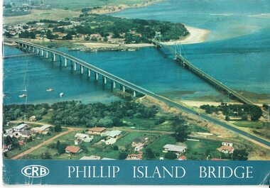
Booklet, Official Opening of the Phillip Island Bridge at San Remo 1969 and notes by the Bridge engineer, Tom Russell, 1969
Prior to 1939 access to the Island was by punt from San Remo or car ferry from Stony Point. A bridge was opened in 1940 but increased traffic and low load capacity was a problem. The decision to build a new bridge was made in the 1960s.HistoricalColoured, bound booklet with a photo of the old and new Phillip Island bridges on the cover and the CRB logo and name on rear. It includes the order of proceedings for the opening and bridge statistics, plans and contractor information. Also photos of construction and a history of travel to the Island before a bridge was built and the first bridge. There is also a 2 page typed document written by the bridge engineer who gives a brief history of access to the Island and problems at the opening with access and a rebel who tried to open it unofficially.Official Opening of the Phillip Island Bridge at San Remo by The Hon. M.V. Porter, MLA. Minister of Public Works. November 21 1969bridges, 2nd phillip island bridge construction, tom russell, phillip island bridge opening 1969 -
 Whitehorse Historical Society Inc.
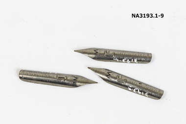
Functional object - Pens, nibs and box
A small box of ball-pointed pen nibs (7 left). A yellow, red and black box containing metal no. 5 & 6M grey nibs. Named as balled-pointed pens, 2L Flewitt's Patent. On back: Suitable for writing in Every position, glide over. Any paper, never scratch nor stick in the paper. Manufactured by D. Leonards & Co. Birmingham. Solely for Ormiston & Glass Ltd. Contractors to H.M. Government 28 Newgate St., London ECcommerce, office equipment / stationery, domestic items, writing equipment -
 Melbourne Tram Museum
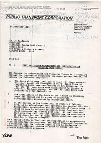
Letter, Public Transport Corporation (PTC), "Past and future manufacture and installation of modified tram doors", Feb. 1990
Photocopy of a two page letter to Mr. J. Halfpenny of the Victorian Trades Hall Council, dated 20/2/1990 on PTC letter head titled "Past and future manufacture and installation of modified tram doors", providing information on the a request for information providing information on the supply and installation of new doors to Z class trams, contractors, manufacturers. Problems with modification program, in house work and may require further discussions. Signed by Bruce Shaw, General Manager, Industrial Relations.Has various notations and numbers in the top right hand corner.trams, tramways, preston workshops, z3 class, motors -
 Bendigo Historical Society Inc.
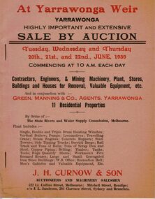
Document - IAN DYETT COLLECTION: AUCTION CATALOGUE - YARRAWONGA WEIR
Two beige coloured auction catalogues with red and black printing for a sale on the 20th, 21st and 22nd June 1939. For sale were Contractors, Engineers & Mining Machinery, Plant, Stores, Buildings and Houses for Removal, Valuable Equipment, etc and 11 Residential Properties By Order of the State Rivers and Water Supply Commission, Melbourne. H. Curnow & Son in conjunction with Green, Manning & Co, Agents, Yarrawonga were the auctioneers. Contains some information about the Yarrawonga Weir and a black and white photo of the bank.business, auctioneers, j h curnow & son pty ltd, ian dyett collection - auction catalogue - yarrawonga weir, green manning & co, the state rivers and water supply commission, j h curnow & son, j l jamieson, messrs a challingsworth pty ltd, jaques bros, austral otis eng co, mr e d shaw, r g knight, h h c williams, f a nevill, the cambridge press -
 Kew Historical Society Inc
Plan, Melbourne & Metropolitan Board of Works : Borough of Kew : Detail Plan No.1350, 1910
The Melbourne and Metropolitan Board of Works (MMBW) plans were produced from the 1890s to the 1950s. They were crucial to the design and development of Melbourne's sewerage and drainage system. The plans, at a scale of 40 feet to 1 inch (1:480), provide a detailed historical record of Melbourne streetscapes and environmental features. Each plan covers one or two street blocks (roughly six streets), showing details of buildings, including garden layouts and ownership boundaries, and features such as laneways, drains, bridges, parks, municipal boundaries and other prominent landmarks as they existed at the time each plan was produced. (Source: State Library of Victoria). This plan forms part of a large group of MMBW plans and maps that was donated to the Society by the Mr Poulter, City Engineer of the City of Kew in 1989. Within this collection, thirty-five hand-coloured plans, backed with linen, are of statewide significance as they include annotations that provide details of construction materials used in buildings in the first decade of the 20th century as well as additional information about land ownership and usage. The copies in the Public Record Office Victoria and the State Library of Victoria are monochrome versions which do not denote building materials so that the maps in this collection are invaluable and unique tools for researchers and heritage consultants. A number of the plans are not held in the collection of the State Library of Victoria so they have the additional attribute of rarity.Original survey plan, issued by the MMBW to a contractor with responsibility for constructing sewers in the area identified on the plan within the Borough of Kew. The plan was at some stage hand-coloured, possibly by the contractor, but more likely by officers working in the Engineering Department of the Borough and later Town, then City of Kew. The hand-coloured sections of buildings on the plan were used to denote masonry or brick constructions (pink), weatherboard constructions (yellow), and public buildings (grey). MMBW Plan No. 1350 depicts the western end of Studley Park on the north side of the Studley Park Road. ‘Raheen’, then the home of Sir Henry Wrixon is named, the plan identifying those parts of the house that were built of brick and timber. The two houses between Raheen and the River Yarra are also shown. Other parts of the plan show neighbouring streets: Yarra Street, Studley Park Avenue, Studley Street and Fenwick Street. Each, apart from Fenwick Street was subsequently renamed. At the corner of Fenwick and Stawell Streets, the home of Joseph Butterworth Coombs, later called ‘Hope Mansell’, is represented but unnamed.melbourne and metropolitan board of works, detail plans, mmbw 1350, cartography -
 Kew Historical Society Inc
Plan, Melbourne & Metropolitan Board of Works : Borough of Kew : Detail Plan No.1565, 1905
The Melbourne and Metropolitan Board of Works (MMBW) plans were produced from the 1890s to the 1950s. They were crucial to the design and development of Melbourne's sewerage and drainage system. The plans, at a scale of 40 feet to 1 inch (1:480), provide a detailed historical record of Melbourne streetscapes and environmental features. Each plan covers one or two street blocks (roughly six streets), showing details of buildings, including garden layouts and ownership boundaries, and features such as laneways, drains, bridges, parks, municipal boundaries and other prominent landmarks as they existed at the time each plan was produced. (Source: State Library of Victoria). This plan forms part of a large group of MMBW plans and maps that was donated to the Society by the Mr Poulter, City Engineer of the City of Kew in 1989. Within this collection, thirty-five hand-coloured plans, backed with linen, are of statewide significance as they include annotations that provide details of construction materials used in buildings in the first decade of the 20th century as well as additional information about land ownership and usage. The copies in the Public Record Office Victoria and the State Library of Victoria are monochrome versions which do not denote building materials so that the maps in this collection are invaluable and unique tools for researchers and heritage consultants. A number of the plans are not held in the collection of the State Library of Victoria so they have the additional attribute of rarity.Original survey plan, issued by the MMBW to a contractor with responsibility for constructing sewers in the area identified on the plan within the Borough of Kew. The plan was at some stage hand-coloured, possibly by the contractor, but more likely by officers working in the Engineering Department of the Borough and later Town, then City of Kew. The hand-coloured sections of buildings on the plan were used to denote masonry or brick constructions (pink), weatherboard constructions (yellow), and public buildings (grey). MMBW Plan No.1565 is an example of a plan where a number of streets have been created since the area was surveyed, or in other cases renamed. The plan shows those streets that were bordered by Ross Street, Mount Street, Sackville Street and Burke Road. Since 1905, Mawson Street has been created and Mont Albert Road renamed as Dean Street. Named houses on the plan include ‘Tyrol’, ‘Glengorse’, ‘Theodore Villa’, ‘Arncliffe’, ‘Ballynira’ and ‘Hazeldene’. The plan also shows a Wesleyan Church in Sackville Street. In 1883, the Church’s Sunday School celebrated its silver anniversary.melbourne and metropolitan board of works, detail plans, mmbw 1565, cartography -
 Warrnambool and District Historical Society Inc.
Administrative record - Ledger, Day Book, early 20th century
The business connected to this ledger, dated from 1904 to 1907, is unknown. There are some local Warrnambool and district names but most refer to other places in Victoria and interstate. The entries mostly deal with the sale of produce - onions, potatoes, barley, oats etc. and the names of ships are usually appended . One can guess that the ledger comes from a Steamship Company, a produce buyer or a cartage contractor.This ledger is of minor interest and is retained for research purposes.This is a ledger of 755 pages. The cover is charcoal-coloured hard board with brown leather on the spine and the edges of the cover. The spine has a red label with gold-coloured lettering. The pages have ruled red lines and handwriting in black ink. The ledger is much stained and tattered at the edges.Day Bookwestern district produce -
 Whitehorse Historical Society Inc.
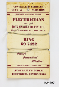
Tool - Fuse wire, c1950
Fuse wire loops on cardboard card which has John March & Con P/L Electricians, marked.Fuse wire card - Controlled vehicles, City and suburbs/ Immediate breakdown service, Electricians, Est 1906. John March & Co P/L, 43-45 Hancock St. Sth Melb. Light, ring 697422, Power, Prompt Personalised Attention. Installations & alterations, Australia's Oldest Electrical Contractors.electrical technology, appliances & accessories -
 Ararat & District Historical Society (operating the Langi Morgala Museum)
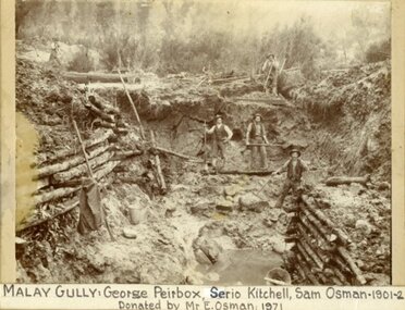
Photograph
Shows the Ararat district's rich mining history.Black and White photo of five miners digging in a pit at Malay Gully, Mafeking. Three of the men are named George Peirbox, Serio Kitchell and Sam Osman. The sides of the pit are supported by horizontal logs.Label on front: Malay Gully, George Peirbox, Serio Kitchell, Sam Osman 1901-2 donated by Mr E Osman 1971. On back of photo: Property of E. Osman housemover and contractor ph 477 Ararat, donated by E. Osman Malay Gully Mafeking down from Browing Claim. -
 Ballarat Clarendon College
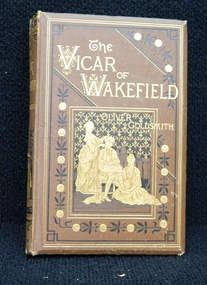
Book, Bickers and son, The Vicar of Wakefield, 1883
This book was awarded to David McMurtrie Paterson for English as first prize in the fourth form in 1886. David enrolled in Ballarat College in 1886 at the age of 14. In the original register it lists parent/guardian as John Paterson, contractor, residing at 12 Errard Street South. It also states that previous school was SS.33, upper VI th form [subsequently known as Dana Street P.S].Presbyterian educators placed great value on a classical education matched with diligence in study. Book prizes were highly regarded and academic success admired. In the school’s early years prizes were ordered direct from London and had the school crest embossed in gold on the front or back cover. Many of the prizes given in early years were returned to the school to equip the Weatherly Library when it opened in 1936.Bound in brown cloth with black and gilt illustrated front cover and spine. College crest embossed on back cover. Gilt edges, black and white illustrations throughout, detached spine and pages, slight foxing on pages, 308 p.Book plate inside front cover: college crest/ English/ Fourth Form,/ First Prize./ Awarded to/ D. Paterson/ Christmas. 1886.david-mcmurtrie-paterson, book-prize, english, 1886, ballarat-college, john-paterson, ss-33. -
 Victorian Interpretive Projects Inc.
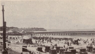
Image, Portland, 1934
The Portland Pier was extended in 1916: "The contractors for the extension or the deep-water pier continue to make steady progress, and the work is nearing completion. Only a small gap on the south end remains to be filled with piling. The beams and decking have been laid down over the whole of the rest of the pier, and the effect im presses one with the magnitude, stability and excellence of the work." (Horsham Times 23 June 1916)A number of people on the beach at Portland near the pier. A number of cars are parked in the foreground.potland, sea, -
 Melbourne Tram Museum
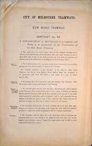
Document - Specification, Melbourne Tramways Trust (MTT), Kew Horse Tramway - Contract No. 53, 1887
Provides a detailed specification of materials to be supplied and the works to be performed for the construction of the Kew Horse Tramway between Victoria Bridge and the Kew Cemetery. Has a schedule of rates. Details materials to be supplied by the contractor. Note it is headed "City of Melbourne Tramways". The Kew Horse Tramway was opened 28-12-1887. It was built by the Melbourne Tramways Trust and operated by the cable tram operator, Melbourne Tramway and Omnibus Co. Yields information about the construction of the Kew horse tram line.Printed 5 page foolscap document stapled with a cut diagonal piece in the top left hand corner titled - Kew Horse Tramway - Contract No. 53.mtt, melbourne tramways trust, horse trams, kew horse tram, victoria bridge -
 Melbourne Tram Museum
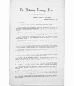
Document - Report, George Duncan, "Report to Public Works Committee, Melbourne Tramways Trust", 9/1884
Printed report - four pages - typeset on foolscap paper, dated 16/9/1884 from George Duncan, Engineer Melbourne Tramways Trust, to the Public Works Committee of Parliament and the Melbourne Tramways Trust", "Report to Public Works Committee, Melbourne Tramways Trust" advising on the construction methodology and financial arrangements along with estimates, mode of construction whether by day labour or by contractors, gives a summary of mileage (was some 33miles of cable and 15 miles of horse), estimates and proposed lines showing whether horse or cable.9/1884trams, tramways, mtt, cable trams, melbourne tramways trust, construction, finances, mto co, parliament -
 Bendigo Historical Society Inc.
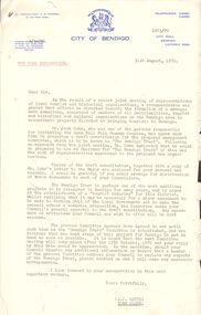
Document - THE BENDIGO TRUST COLLECTION: VARIOUS CORRESPONDENCE, 31st August, 1970
Various correspondence relating to the Bendigo Trust a. City of Bendigo to ''For Your Information'' (non name) signed A J Watts 31/9/1970; from J M Cohn to The Mayor, City of Bendigo 26/8/1970 - other letters attached to a Draft Constitution for the Bendigo Trust; Notices of 'Next Meeting for committee of the Bendigo Trust various meetings from Dec 1970 - Oct 1971; Letter from H. Biggs, Secretary to Members of the Bendigo Trust re: meeting with contractor September 1971.organization, club/society, bendigo trust -
 Ballarat Heritage Services
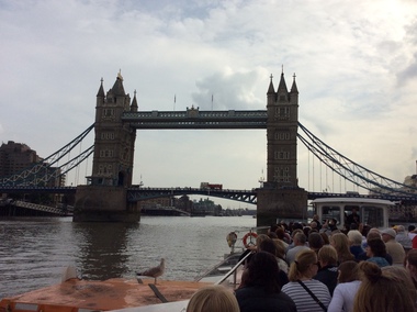
Digital photograph, Dorothy Wickham, Tower Bridge, London, 2016, 19/09/2016
It took eight years, five major contractors and the relentless labour of 432 construction workers to build Tower Bridge. Two massive piers were sunk into the river bed to support the construction and over 11,000 tons of steel provided the framework for the Towers and Walkways. This framework was clad in Cornish granite and Portland stone to protect the underlying steelwork and to give the Bridge a more pleasing appearance.(http://www.towerbridge.org.uk/bridge-history/)tower bridge, london -
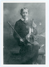 Mt Dandenong & District Historical Society Inc.
Photograph, Edward John Price aged 14
John Lundy-Clarke grew up in the Kalorama/Mt Dandenong area and later in life (1972-74) began to write a comprehensive history of the district working from an original settlement map in an effort to cover all areas. Edward John Price (1898 - 1974) was the son of early settlers on Lot 1 of the Village Settlement Edward Joseph Price and Annie (nee Ross) Price. He was the brother of Charles and Kathleen Price. Edward John married Myra Wilson in 1930.Black and white studio portrait showing well groomed boy holding a violin. Reverse of photograph has handwritten description by John Lundy-Clarke.Edward John Price aged 14. Son of Edward Joseph Price and Annie Ada nee Ross. Farmer, sawmiller, logging contractor,. proprietor of shop at Kew Junction 1935. Quarry master (Kilsyth). Father of Alan and Eddie J. A daughter died young. Married Myra Wilson 1930. Died 1974.edward john price, edward joseph price, annie price, annie ross, kathleen price, charles price -
 Glen Eira Historical Society
Album - Album page, Hotham Street, Circa 1972
... contractors ...This photograph is part of the Caulfield Historical Album 1972. This album was created in approximately 1972 as part of a project by the Caulfield Historical Society to assist in identifying buildings worthy of preservation. The album is related to a Survey the Caulfield Historical Society developed in collaboration with the National Trust of Australia (Victoria) and Caulfield City Council to identify historic buildings within the City of Caulfield that warranted the protection of a National Trust Classification. Principal photographer thought to be Trevor Hart, member of Caulfield Historical Society. Most photographs were taken between 1966-1972 with a small number of photographs being older and from unknown sources. All photographs are black and white except where stated, with 386 photographs over 198 pages.Victorian Heritage Database - Hotham Street Road Overbridge HO116 Heritage Overlay - City of Glen Eira https://vhd.heritagecouncil.vic.gov.au/places/43557 (as of 04/07/2021) The Hotham Street road overbridge is located on the Sandringham railway line between Ripponlea and Elsternwick railway stations. It is presumed to have been built by contractors Sharp and Campbell who signed a contract on 25th . November, 1881 to construct a second line of railway between Windsor and Elsternwick. This contract was completed during 1882 and the bridge may have been designed in the year when Robert Watson took over from William Elsdon as engineer in chief for the Victorian railways. It is historically, aesthetically and technically significant. It is historically significant (Criterion A) to the extent that it demonstrates the standards of construction adopted by the Victorian Railways Department when it rebuilt the lines acquired from the private railway companies, (compare the Geelong and Melbourne Railway Co's line from Newport to Geelong, acquired in 1860). It is aesthetically significant (Criterion E) as an intact nineteenth century structure of its type, many similar girder bridges having been renewed with concrete girders in recent years. The bluestone abutments demonstrate high standards of stone masonry and are representative of Departmental work of the period. This bridge forms one of a group of historic structures on the railway to Brighton Beach and therefore contributes to the line's cultural importance as a whole. The survival of the riveted iron girders with their bellied angle iron struts is important since these elements are representative of the civil engineering practices of the Victorian Railways at the time and constitute the technical significance (Criterion F) of the structure.Page 96 of Photograph Album with three photographs (one portrait and two landscape) from Hotham Street - two external views of one house and a railway bridge.Handwritten: Hotham Street [top right] / 112 HOTHAM ST [under top left photo] / BRIDGE OVER SANDRINGHAM RAILWAY [under top right photo] / 112 HOTHAM ST CNR MELBY AVE [under bottom left photo] / 96 [bottom right]trevor hart, elsternwick, hotham street, caulfield, houses, brick, bay windows, verandahs, railway bridges, tunnels, gardens, bluestone, civil engineering, victorian railways, sharp and campbell, contractors -
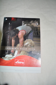 National Wool Museum
Shearer's Tally Book
Used for keeping record of sheep shorn by individual shearers. The final number of sheep shorn by each shearer are used to calculate payment. Provides wool grower with statistical information about how many sheep on property and where they are. Depends how many people on site who keeps the shearers tallies eg the contractor, property owner, station hand. Used also to keep shearers honest about their totals and therefore their pay.Booklet with image of man shearing a sheep.Shearer's Tally Book. Eldersshearers, tally book, shearing, sheep -
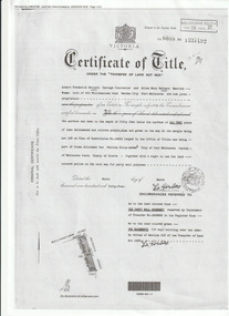 Port Melbourne Historical & Preservation Society
Document (Item), Certificate of Title 400 Williamstown Road, Port Melbourne, 9 Mar 1944
The Certificate of Title states that "Robert Fredrick WATTERS, Cartage Contractor and Ellen Mary WATTERS, Married Woman, both of 400 Williamstown Road, Garden City, Port Melbourne are now Joint Proprietors" of Garden City house & land on the corner of Williamstown and Beacon Roads. in 1963 Ellen became the Surviving Proprietor and 1966 the property passed to Ellen Patricia WATTERS and Norma Madeline WATTERS. Norma was registered as the Surviving Proprietor in 1984. built environment - domestic, garden city, robert fredrick watters, ellen mary watters, ellen patricia watters, norma madeline watters, williamstown road -
 Seaworks Maritime Museum
Plaque
In 2010, the Government announced that the ETV fleet would be no longer be funded by the MCA from September 2011, saving £32.5m over the Spending Review period. The Department stated that "state provision of ETVs does not represent a correct use of taxpayers money and that ship salvage should be a commercial matter between a ship's operator and the salvor".Two days after the announcement that the fleet was to be disbanded, Anglian Prince was sent to the aid of the UK's newest and largest nuclear submarine HMS Astute, which ran aground off the Isle of Skye in Scotland during sea trials.Builder's plaque, Imai Mfg Co, for the 'Jaramac 48' - Text is impressed into the front and painted red. A red painted border surrounds the edge of the plaque. A small silver plate is attached to the upper right hand corner with engraved text on it.1979 circa. Jaramac 48 - 4,200 HP, Harbour Tug, Built 1975. Renamed 'Mac Tide 48'JARAMC 48/OWNER J. RAY MCDERMOTT & COMPANY INC/ OFFICIAL NO./ GROSS TONNAGE 554t.84/ NET TONNAGE 71t.00/ CONTRACTOR HASEGAWA & CO., LTD./ BUILDER IMAI MFG. CO., LTD/ HULL NO. SHIP NO. 145" Gold Plaque "DONATED BY/ J Ray McDermott (Aust) P/l)/ 1979" -
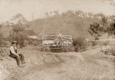 Eltham District Historical Society Inc
Photograph, Mr Belot smokes his pipe whilst resting at Cottle's Bridge, c.1890
The area, previously known as Back Creek, was named after Thomas Cottle, who settled in the district in the 1870s, and the original bridge over the Diamond Creek on the road to Strathewen. The original bridge (seen in the photo) was replaced with a new timber bridge at a cost of £1,500, the tender being awarded to a contractor named Birch who commenced work in June 1927. The gentleman in the photo who is resting whilst having a smoke of his pipe is a member of the Belot family.Original sepia photograph mounted on card broken lower left corner and cracked upper rightbelot, bridge, cottles bridge, cottles bridge-strathewan road, diamond creek (creek), heidelberg-kinglake road -
 NMIT (Northern Melbourne Institute of TAFE)
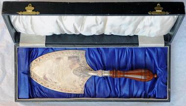
Presentation pieces: CTS 1923, Presentation trowel for laying of foundation stone Collingwood Technical School 1923
Silver presentation trowel with wooden handle in an oblong black box. The trowel has an inscription. The trowel is in an oblong black box which is covered in black leatherette/paper and the inside is lined in royal blue satin on the bottom and in white satin inside the lid. There is supplementary material which includes a black and white photograph H150mm X W 200mm. On the reverse of the photo ‘LAYING FOUNDATION STONE 1923 / Sir Alexander Peacock, Minister for Education’. Other supplementary material icludes copies of four sheets of A4 typed letters dated between 9th October, 1941 and 18th November, 1941 among The Director of the Education Department, The Principal of Collingwood Technical School and The Hon. T. Tunnecliffe, MLA, concerning the wishes of Lady Peacock that the trowel be presented to the school and the school's acceptance of the offer. Also a With compliments slip ' With the Compliments / of / T.Tunnecliffe, M.L.A. / PARLIAMENT HOUSE, / MELBOURNE.' The trowel has an inscription ‘PRESENTED TO / SIR ALEX PEACOCK, M.L.A. / BY / MR. W. BOLGER, CONTRACTOR / FOR THE PURPOSE OF LAYING / THE FOUNDATION STONE / AT / COLLINGWOOD TECHNICAL SCHOOL / SEPT. 4TH 1923’. The box has a gold coloured oval makers stamp on the inside of the lid 'ARMFIELD''S / Watchmaker, Jeweller & Optician / 24 Smith St., COLLINGWOOD'. collingwood technical school, presentations, buildings, nmit, -
 Bendigo Historical Society Inc.
Document - NORMAN OLIVER COLLECTION: MAYOR'S NOTES 1965
The Norman Oliver collection. Norman Oliver was three times Mayor of Bendigo - 1950-51, 1964-65, 1970-71. Three typed pages, undated but in a 1965 sequence. In the same format as 'Mayor Speaks' but untitled. Topics include : poor standard of Council work being done by private contractors, Victorian Promotion Committee and industry problems in Bendigo, discrimination suffered by the Bendigo textile industry, B.L.B. Corporation, tree pollarding, Mr Ross Shelmerdine of the Victorian Churchill Memorial Appeal and the National Heart Foundation, and the spending of monies raised by the Anti Cancer Appeal.bendigo, council, report, norman joseph oliver , councillor norman oliver. mayor of bendigo. -
 Bendigo Historical Society Inc.
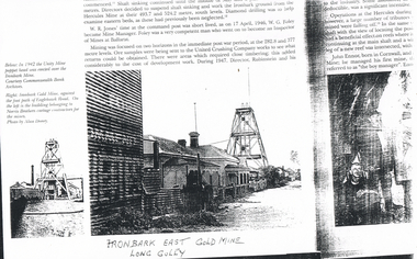
Photograph - LONG GULLY HISTORY GROUP COLLECTION: IRONBARK EAST GOLD MINE
Copy of a page from a book showing a photo of the Ironbark East Gold Mine, Long Gully. Photo shows the poppet head beside the footpath and houses on each side. at the left is a building belonging to Norris Brothers cartage contractors for the mines. Photo by Alan Doney. Also a smaller photo and printing: In 1942 the Unity Mine poppet head was erected over the Ironbark Mine. Courtesy Commonwealth Bank Archives. Written on the back: Eaglehawk Rd. Looking down from Flats (now??) Steel poppet head replaced wooden poppet.bendigo, history, long gully history group, the long gully history group - ironbark east gold mine, unity mine, ironbark mine, commonwealth bank archives, norris brothers, alan doney -
 Bendigo Historical Society Inc.
Document - ''THE TRUE LIFE STORY OF THIS OLD BENDIGO MINER'' W (BILL) A LANGLEY, 21st April, 1967
''The true life story of this old Bendigo miner'' W (Bill) A Langley. Seven typewritten pages of reminiscences of various types of (labouring) work. As provided by author,21/4/1967, aged 82 years. Mention of breweries in Bendigo (Bruce; Pritchard; Chamberlin; Cohn Bros; Hunter Bros; Stewards (Eaglehawk); Italian contractor - G. Vanosio (Back Creek); George Edwards (skin buyer, Market Square); Hercules and Energetic mine; Hustlers Reef mine; Prices of various things purchased in late 1890s; costs of various entertainments at that time.W.A. Langleyperson, individual, w. a. langley, new chum railway mine, mr charles rowe, chinese camp at ironbark and bridge street, bob lewis, jim scobie, bob lewis, bruce brewery, pritchard and chamblin, cohn bros, hunter bros, illingsworth and stewards brewery, white hills cemetary, george edwards, harry hoy, g. svanosio, back creek, hercules mine, energetic mine, sea company mine, hustlers reef mine, jim mcdonald, bendigo pottery, beehive exchange. -
 Kew Historical Society Inc
Plan, Melbourne & Metropolitan Board of Works : Borough of Kew : Detail Plan No.1564, 1905
The Melbourne and Metropolitan Board of Works (MMBW) plans were produced from the 1890s to the 1950s. They were crucial to the design and development of Melbourne's sewerage and drainage system. The plans, at a scale of 40 feet to 1 inch (1:480), provide a detailed historical record of Melbourne streetscapes and environmental features. Each plan covers one or two street blocks (roughly six streets), showing details of buildings, including garden layouts and ownership boundaries, and features such as laneways, drains, bridges, parks, municipal boundaries and other prominent landmarks as they existed at the time each plan was produced. (Source: State Library of Victoria)This plan forms part of a large group of MMBW plans and maps that was donated to the Society by the Mr Poulter, City Engineer of the City of Kew in 1989. Within this collection, thirty-five hand-coloured plans, backed with linen, are of statewide significance as they include annotations that provide details of construction materials used in buildings in the first decade of the 20th century as well as additional information about land ownership and usage. The copies in the Public Record Office Victoria and the State Library of Victoria are monochrome versions which do not denote building materials so that the maps in this collection are invaluable and unique tools for researchers and heritage consultants. A number of the plans are not held in the collection of the State Library of Victoria so they have the additional attribute of rarity.Original survey plan, issued by the MMBW to a contractor with responsibility for constructing sewers in the area identified on the plan within the Borough of Kew. The plan was at some stage hand-coloured, possibly by the contractor, but more likely by officers working in the Engineering Department of the Borough and later Town, then City of Kew. The hand-coloured sections of buildings on the plan were used to denote masonry or brick constructions (pink), weatherboard constructions (yellow), and public buildings (grey). In 1905, when Plan No.1564 was printed, that part of Kew bordered by Brougham Place (now Daniell Place), Mount Street, Sackville Street and Ross Street was already the location of a number of large mansions. Here, subdivisions, at least at this stage, produced larger blocks than in Central Kew. Many of the houses on this plan are named: ‘Faybrook’, ‘Northumbria’, ‘Parkholm[e]’, ‘Dunboe’, ‘Katoomba’ and ‘Eschol’ fronting Sackville Street. Eschol was once the home of the manufacturer Robert Harrison, whose cordial factory in Spring and Argyle Streets Fitzroy are noted on the Victorian Heritage Register. ‘The Hawthorns’ on the corner of Brougham Place and Mount Street was the home of the medical practitioner Frank William Fay, who won the military cross and other honours for conspicuous gallantry and devotion to duty in World War 1.melbourne and metropolitan board of works, detail plans, mmbw 1564, cartography -
 Kew Historical Society Inc
Plan, Melbourne & Metropolitan Board of Works : Borough of Kew : Detail Plan No.1570, 1905
The Melbourne and Metropolitan Board of Works (MMBW) plans were produced from the 1890s to the 1950s. They were crucial to the design and development of Melbourne's sewerage and drainage system. The plans, at a scale of 40 feet to 1 inch (1:480), provide a detailed historical record of Melbourne streetscapes and environmental features. Each plan covers one or two street blocks (roughly six streets), showing details of buildings, including garden layouts and ownership boundaries, and features such as laneways, drains, bridges, parks, municipal boundaries and other prominent landmarks as they existed at the time each plan was produced. (Source: State Library of Victoria)This plan forms part of a large group of MMBW plans and maps that was donated to the Society by the Mr Poulter, City Engineer of the City of Kew in 1989. Within this collection, thirty-five hand-coloured plans, backed with linen, are of statewide significance as they include annotations that provide details of construction materials used in buildings in the first decade of the 20th century as well as additional information about land ownership and usage. The copies in the Public Record Office Victoria and the State Library of Victoria are monochrome versions which do not denote building materials so that the maps in this collection are invaluable and unique tools for researchers and heritage consultants. A number of the plans are not held in the collection of the State Library of Victoria so they have the additional attribute of rarity.Original survey plan, issued by the MMBW to a contractor with responsibility for constructing sewers in the area identified on the plan within the Borough of Kew. The plan was at some stage hand-coloured, possibly by the contractor, but more likely by officers working in the Engineering Department of the Borough and later Town, then City of Kew. The hand-coloured sections of buildings on the plan were used to denote masonry or brick constructions (pink), weatherboard constructions (yellow), and public buildings (grey). Plan No.1570 shows the layout of gardens and houses in Sackville Street, Davis Street, Wrixon Street, and Fitzwilliam Street in 1904. While Thomas Street is included on the map, at this stage no houses had been built. The plan identifies two named houses: ‘Fairview’ and ‘Kylemore’. Fairview is more fully delineated in Plan No.1563. Kylemore is one of the few houses in Kew designed by John Beswicke. The most notable owner of Kylemore was William Whitehead, who owned the house between 1895 and 1900. In 1894, Australian newspapers reported the marriage of Whitehead’s daughter to Dr. Gerald Eugene Cussen, the brother of Sir Leo Cussen, the Supreme Court Judge. The married couple was to live at ‘Wilton’ (now the Kew RSL) from 1911-15.melbourne and metropolitan board of works, detail plans, mmbw 1570, cartography -
 Kew Historical Society Inc
Plan, Melbourne & Metropolitan Board of Works : Borough of Kew : Detail Plan No.1572, 1905
The Melbourne and Metropolitan Board of Works (MMBW) plans were produced from the 1890s to the 1950s. They were crucial to the design and development of Melbourne's sewerage and drainage system. The plans, at a scale of 40 feet to 1 inch (1:480), provide a detailed historical record of Melbourne streetscapes and environmental features. Each plan covers one or two street blocks (roughly six streets), showing details of buildings, including garden layouts and ownership boundaries, and features such as laneways, drains, bridges, parks, municipal boundaries and other prominent landmarks as they existed at the time each plan was produced. (Source: State Library of Victoria)This plan forms part of a large group of MMBW plans and maps that was donated to the Society by the Mr Poulter, City Engineer of the City of Kew in 1989. Within this collection, thirty-five hand-coloured plans, backed with linen, are of statewide significance as they include annotations that provide details of construction materials used in buildings in the first decade of the 20th century as well as additional information about land ownership and usage. The copies in the Public Record Office Victoria and the State Library of Victoria are monochrome versions which do not denote building materials so that the maps in this collection are invaluable and unique tools for researchers and heritage consultants. A number of the plans are not held in the collection of the State Library of Victoria so they have the additional attribute of rarity.Original survey plan, issued by the MMBW to a contractor with responsibility for constructing sewers in the area identified on the plan within the Borough of Kew. The plan was at some stage hand-coloured, possibly by the contractor, but more likely by officers working in the Engineering Department of the Borough and later Town, then City of Kew. The hand-coloured sections of buildings on the plan were used to denote masonry or brick constructions (pink), weatherboard constructions (yellow), and public buildings (grey). Plan No. 1572 represents the built environment bordered by Barkers Road, Wrixon Street, Edgevale Road and Fitzwilliam Street. Other streets identified on the plan include Stansell Street. Plan 1572 shows that by 1903-05, there was only patchy development in this area of Kew, mainly on Edgevale Road and Fitzwilliam Street. Only two named houses are identified: the quaintly named ‘Tweed Cottage’, and ‘Mendip’. The earliest reference to Treed Cottage in Australian newspapers is to the death of Walter Thompson, aged 74 who was a resident there in 1885. His youngest daughter was to die there in 1908. Mendip to the north of Tweed Cottage was owned by Henry Thompson; he was to die in 1901; his wife in 1932. At this period of time, Malin Street and Clivedon Court did not extend to Barkers Road.melbourne and metropolitan board of works, detail plans, mmbw 1572, cartography -
 Kew Historical Society Inc
Plan, Melbourne & Metropolitan Board of Works. Borough of Kew Detail Plan No.1579, 1904
The Melbourne and Metropolitan Board of Works (MMBW) plans were produced from the 1890s to the 1950s. They were crucial to the design and development of Melbourne's sewerage and drainage system. The plans, at a scale of 40 feet to 1 inch (1:480), provide a detailed historical record of Melbourne streetscapes and environmental features. Each plan covers one or two street blocks (roughly six streets), showing details of buildings, including garden layouts and ownership boundaries, and features such as laneways, drains, bridges, parks, municipal boundaries and other prominent landmarks as they existed at the time each plan was produced. (Source: State Library of Victoria). This plan forms part of a large group of MMBW plans and maps that was donated to the Society by the Mr Poulter, City Engineer of the City of Kew in 1989. Within this collection, thirty-five hand-coloured plans, backed with linen, are of statewide significance as they include annotations that provide details of construction materials used in buildings in the first decade of the 20th century as well as additional information about land ownership and usage. The copies in the Public Record Office Victoria and the State Library of Victoria are monochrome versions which do not denote building materials so that the maps in this collection are invaluable and unique tools for researchers and heritage consultants. A number of the plans are not held in the collection of the State Library of Victoria so they have the additional attribute of rarity.Original survey plan, issued by the MMBW to a contractor with responsibility for constructing sewers in the area identified on the plan within the Borough of Kew. The plan was at some stage hand-coloured, possibly by the contractor, but more likely by officers working in the Engineering Department of the Borough and later Town, then City of Kew. The hand-coloured sections of buildings on the plan were used to denote masonry or brick constructions (pink), weatherboard constructions (yellow), and public buildings (grey). While MMBW Plan No.1579 does not include many buildings, those that it does show are significant to Kew’s history. These include the ‘Kew [Railway] Station’ in Denmark Street and the ‘Recreation Hall’ and rear courts off Wellington Street. The plan shows the outline of the Recreation Hall, constructed in 1880, at the rear of which is listed a bowling green, two tennis courts, a ‘skittle alley’ and a pavilion. When the Hall was first built, the Kew Cricket Club occupied an adjacent ground, however in 1885 this was acquired by the State Government as the future location of the Kew Railway Station. The Plan also shows a single oval at Xavier College. This oval was completed in 1883. One of the current ovals conforms to this oval’s original shape and position in the school grounds.melbourne and metropolitan board of works, detail plans, maps - borough of kew, mmbw 1579, cartography -
 Kew Historical Society Inc
Plan, Melbourne & Metropolitan Board of Works / Borough of Kew, Detail Plan No.1593, 1905
The Melbourne and Metropolitan Board of Works (MMBW) plans were produced from the 1890s to the 1950s. They were crucial to the design and development of Melbourne's sewerage and drainage system. The plans, at a scale of 40 feet to 1 inch (1:480), provide a detailed historical record of Melbourne streetscapes and environmental features. Each plan covers one or two street blocks (roughly six streets), showing details of buildings, including garden layouts and ownership boundaries, and features such as laneways, drains, bridges, parks, municipal boundaries and other prominent landmarks as they existed at the time each plan was produced. (Source: State Library of Victoria)This plan forms part of a large group of MMBW plans and maps that was donated to the Society by the Mr Poulter, City Engineer of the City of Kew in 1989. Within this collection, thirty-five hand-coloured plans, backed with linen, are of statewide significance as they include annotations that provide details of construction materials used in buildings in the first decade of the 20th century as well as additional information about land ownership and usage. The copies in the Public Record Office Victoria and the State Library of Victoria are monochrome versions which do not denote building materials so that the maps in this collection are invaluable and unique tools for researchers and heritage consultants. A number of the plans are not held in the collection of the State Library of Victoria so they have the additional attribute of rarity.Original survey plan, issued by the MMBW to a contractor with responsibility for constructing sewers in the area identified on the plan within the Borough of Kew. The plan was at some stage hand-coloured, possibly by the contractor, but more likely by officers working in the Engineering Department of the Borough and later Town, then City of Kew. The hand-coloured sections of buildings on the plan were used to denote masonry or brick constructions (pink), weatherboard constructions (yellow), and public buildings (grey). The laborious task of hand-tinting these Board of Works plans was not without hazards as is evidenced by Plan No. 1593. On the Plan, the original colourist spilt black and green ink, partially obscuring some parts. The most obvious casualty is ‘Clifton’ located on the corner of Cotham Road and Park Street [now Adeney Avenue]. Included in this Plan, and outlined in pink is that part of the section that the contracting engineer was tasked with completing. This included sewering on both sides of this part of Cotham Road, but excluded properties such as ‘Glendonald’ and ‘Monnington’. This area was to undergo a series of subdivisions including the ‘Clifton Estate’, which created housing lots on Adeney Avenue and Florence Avenue in 1916. The most notable occupant of Clifton was William Adeney [died 1893], a pioneer of Camperdown, after which Park Street was later renamed.melbourne and metropolitan board of works, detail plans, survey plans - borough of kew, mmbw 1593, cartography