Showing 316 items
matching excavations
-
 Ballarat Heritage Services
Photograph - Colour, Mason's Marks, Carlisle Cathedral 27 October 2016
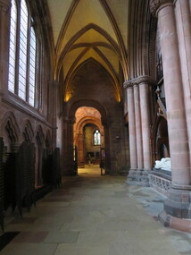
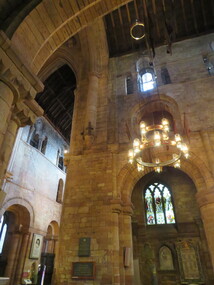
Carlisle and its cathedral. This cathedral church, which has stood on this site for over 800 years has a great story to tell. It is a story that can be traced back further still, to an even earlier church of the 7th century AD. Archaeological excavations on this site have taken the story back to Roman times. Today the dean and canons and other cathedral staff ensure that the worship of God remains the main work of this cathedral, while long-standing traditions of music, hospitality and education are also maintained. The story of this place is not so much about buildings, but about people. The buildings remain as evidence of the lives of people who lived and worked here and of what they believed and achieved. Until 1540 a community of Augustinian canons served the cathedral. They lived highly organized lives in monastic buildings suited to their needs. As canons rather than monks, they were freer to undertake pastoral and educational work. carlisle, cathedral, stonemasons, mason's marks -
 Ballarat Heritage Services
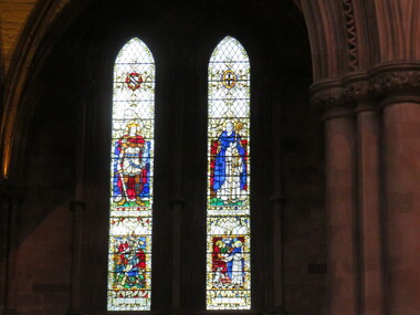
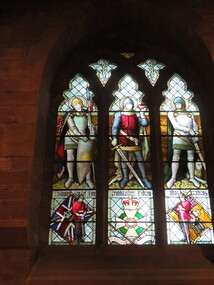
Photograph - Colour, Stained glass windows, Carlisle Cathedral 27 October 2016
Carlisle and its cathedral. This cathedral church, which has stood on this site for over 800 years has a great story to tell. It is a story that can be traced back further still, to an even earlier church of the 7th century AD. Archaeological excavations on this site have taken the story back to Roman times. Today the dean and canons and other cathedral staff ensure that the worship of God remains the main work of this cathedral, while long-standing traditions of music, hospitality and education are also maintained. The story of this place is not so much about buildings, but about people. The buildings remain as evidence of the lives of people who lived and worked here and of what they believed and achieved. Until 1540 a community of Augustinian canons served the cathedral. They lived highly organized lives in monastic buildings suited to their needs. As canons rather than monks, they were freer to undertake pastoral and educational work. carlisle, cathedral, stonemasons, mason's marks -
 Ballarat Heritage Services
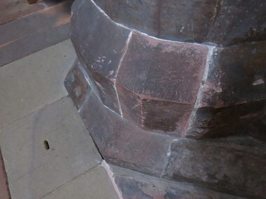
Photograph - Colour, Stonework, Carlisle Cathedral 27 October 2016
Carlisle and its cathedral. This cathedral church, which has stood on this site for over 800 years has a great story to tell. It is a story that can be traced back further still, to an even earlier church of the 7th century AD. Archaeological excavations on this site have taken the story back to Roman times. Today the dean and canons and other cathedral staff ensure that the worship of God remains the main work of this cathedral, while long-standing traditions of music, hospitality and education are also maintained. The story of this place is not so much about buildings, but about people. The buildings remain as evidence of the lives of people who lived and worked here and of what they believed and achieved. Until 1540 a community of Augustinian canons served the cathedral. They lived highly organized lives in monastic buildings suited to their needs. As canons rather than monks, they were freer to undertake pastoral and educational work. carlisle, cathedral, stonemasons, mason's marks -
 Ballarat Heritage Services
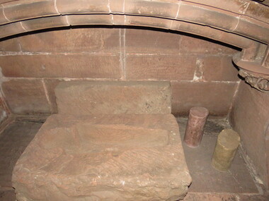
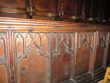
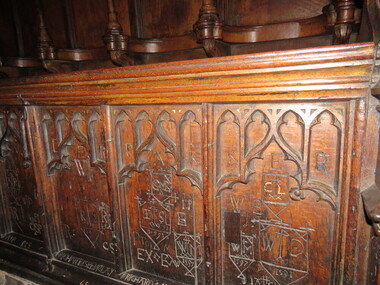
Photograph - Colour, Graffiti, Carlisle Cathedral 27 October 2016
Carlisle and its cathedral. This cathedral church, which has stood on this site for over 800 years has a great story to tell. It is a story that can be traced back further still, to an even earlier church of the 7th century AD. Archaeological excavations on this site have taken the story back to Roman times. Today the dean and canons and other cathedral staff ensure that the worship of God remains the main work of this cathedral, while long-standing traditions of music, hospitality and education are also maintained. The story of this place is not so much about buildings, but about people. The buildings remain as evidence of the lives of people who lived and worked here and of what they believed and achieved. Until 1540 a community of Augustinian canons served the cathedral. They lived highly organized lives in monastic buildings suited to their needs. As canons rather than monks, they were freer to undertake pastoral and educational work. carlisle, cathedral, stonemasons, mason's marks -
 Ballarat Heritage Services
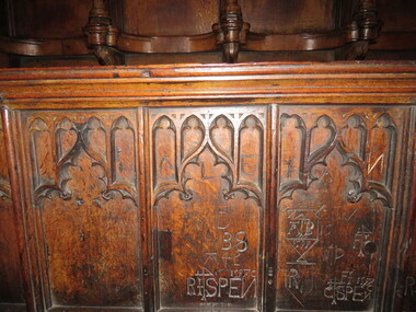
Photograph - Colour, Graffiti, Carlisle Cathedral 27 October 2016
Carlisle and its cathedral. This cathedral church, which has stood on this site for over 800 years has a great story to tell. It is a story that can be traced back further still, to an even earlier church of the 7th century AD. Archaeological excavations on this site have taken the story back to Roman times. Today the dean and canons and other cathedral staff ensure that the worship of God remains the main work of this cathedral, while long-standing traditions of music, hospitality and education are also maintained. The story of this place is not so much about buildings, but about people. The buildings remain as evidence of the lives of people who lived and worked here and of what they believed and achieved. Until 1540 a community of Augustinian canons served the cathedral. They lived highly organized lives in monastic buildings suited to their needs. As canons rather than monks, they were freer to undertake pastoral and educational work. carlisle, cathedral, stonemasons, mason's marks -
 Ballarat Heritage Services
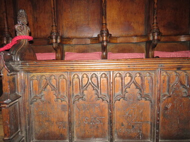
Photograph - Colour, Graffiti, Carlisle Cathedral 27 October 2016
Carlisle and its cathedral. This cathedral church, which has stood on this site for over 800 years has a great story to tell. It is a story that can be traced back further still, to an even earlier church of the 7th century AD. Archaeological excavations on this site have taken the story back to Roman times. Today the dean and canons and other cathedral staff ensure that the worship of God remains the main work of this cathedral, while long-standing traditions of music, hospitality and education are also maintained. The story of this place is not so much about buildings, but about people. The buildings remain as evidence of the lives of people who lived and worked here and of what they believed and achieved. Until 1540 a community of Augustinian canons served the cathedral. They lived highly organized lives in monastic buildings suited to their needs. As canons rather than monks, they were freer to undertake pastoral and educational work. carlisle, cathedral, stonemasons, mason's marks -
 Ballarat Heritage Services
Photograph - Colour, Graffiti, Carlisle Cathedral (made 1500-1600)
Carlisle and its cathedral. This cathedral church, which has stood on this site for over 800 years has a great story to tell. It is a story that can be traced back further still, to an even earlier church of the 7th century AD. Archaeological excavations on this site have taken the story back to Roman times. Today the dean and canons and other cathedral staff ensure that the worship of God remains the main work of this cathedral, while long-standing traditions of music, hospitality and education are also maintained. The story of this place is not so much about buildings, but about people. The buildings remain as evidence of the lives of people who lived and worked here and of what they believed and achieved. Until 1540 a community of Augustinian canons served the cathedral. They lived highly organized lives in monastic buildings suited to their needs. As canons rather than monks, they were freer to undertake pastoral and educational work. Colour photograph of graffiti in a church.carlisle, cathedral, stonemasons, mason's marks, graffiti -
 Ballarat Heritage Services
Photograph - Colour, Stonework, Carlisle Cathedral made 1500-1600
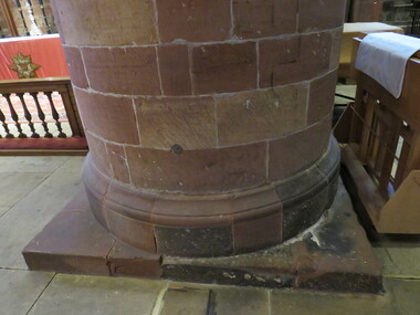
Carlisle and its cathedral. This cathedral church, which has stood on this site for over 800 years has a great story to tell. It is a story that can be traced back further still, to an even earlier church of the 7th century AD. Archaeological excavations on this site have taken the story back to Roman times. Today the dean and canons and other cathedral staff ensure that the worship of God remains the main work of this cathedral, while long-standing traditions of music, hospitality and education are also maintained. The story of this place is not so much about buildings, but about people. The buildings remain as evidence of the lives of people who lived and worked here and of what they believed and achieved. Until 1540 a community of Augustinian canons served the cathedral. They lived highly organized lives in monastic buildings suited to their needs. As canons rather than monks, they were freer to undertake pastoral and educational work. carlisle, cathedral, stonemasons, mason's marks -
 Ballarat Heritage Services
Photograph - Colour, Stonework, Carlisle Cathedral made 1500-1600
Carlisle and its cathedral. This cathedral church, which has stood on this site for over 800 years has a great story to tell. It is a story that can be traced back further still, to an even earlier church of the 7th century AD. Archaeological excavations on this site have taken the story back to Roman times. Today the dean and canons and other cathedral staff ensure that the worship of God remains the main work of this cathedral, while long-standing traditions of music, hospitality and education are also maintained. The story of this place is not so much about buildings, but about people. The buildings remain as evidence of the lives of people who lived and worked here and of what they believed and achieved. Until 1540 a community of Augustinian canons served the cathedral. They lived highly organized lives in monastic buildings suited to their needs. As canons rather than monks, they were freer to undertake pastoral and educational work. carlisle, cathedral, stonemasons, mason's marks -
 Ballarat Heritage Services
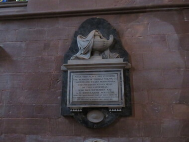
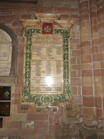
Photograph - Colour, Plaque for Border Regiment, Carlisle Cathedral
Carlisle and its cathedral. This cathedral church, which has stood on this site for over 800 years has a great story to tell. It is a story that can be traced back further still, to an even earlier church of the 7th century AD. Archaeological excavations on this site have taken the story back to Roman times. Today the dean and canons and other cathedral staff ensure that the worship of God remains the main work of this cathedral, while long-standing traditions of music, hospitality and education are also maintained. The story of this place is not so much about buildings, but about people. The buildings remain as evidence of the lives of people who lived and worked here and of what they believed and achieved. Until 1540 a community of Augustinian canons served the cathedral. They lived highly organized lives in monastic buildings suited to their needs. As canons rather than monks, they were freer to undertake pastoral and educational work. carlisle, cathedral, stonemasons, mason's marks -
 Ballarat Heritage Services
Photograph - Photograph - Colour, Stained glass window, Carlisle Cathedral
Carlisle and its cathedral. This cathedral church, which has stood on this site for over 800 years has a great story to tell. It is a story that can be traced back further still, to an even earlier church of the 7th century AD. Archaeological excavations on this site have taken the story back to Roman times. Today the dean and canons and other cathedral staff ensure that the worship of God remains the main work of this cathedral, while long-standing traditions of music, hospitality and education are also maintained. The story of this place is not so much about buildings, but about people. The buildings remain as evidence of the lives of people who lived and worked here and of what they believed and achieved. Until 1540 a community of Augustinian canons served the cathedral. They lived highly organized lives in monastic buildings suited to their needs. As canons rather than monks, they were freer to undertake pastoral and educational work. carlisle, cathedral, stonemasons, mason's marks -
 Bendigo Historical Society Inc.
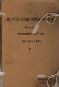
Document - HANRO COLLECTION: DRAWINGS OF THE ERECTION OF THE HANRO KNITTING MILLS, 1926
BHS CollectionDrawings of the Erection of the Hanro Knitting Mills: In a binder made of pieces of brown cardboard top, bottom and spine joined together with white cotton ribbon to form the binder. On the front is a number on a white sticker in black biro * D1710* on the right hand top. In the centre top is the blue circular Royal Historical society of Victoria. Bendigo Branch. Underneath that, hand written script in black ink is *Hanro 'Aust. Bendigo Knitting Mills Pty. Ltd. Drawings in connection with the erection of New Mills* and a small star drawn in black ink. At the right bottom is *William Rockli C.E. Melbourne. On the spine is *Drawings in connection with the Erection of New Mill*. The spine has had a 7cm piece torn off. Inside the front is a white sheet of paper glued to the cover. Its title underlined *List of Drawings Job No. 37. 'Hanro' Aust. Bendigo Knitting Mills Pty. Ltd.* Drawings No 8-34 and 1 copy Tender, *Specifications and General Conditions for Steel Roof Construction*. Plus 1 copy Tender, *Specifications and General Conditions for Excavation, Brick Work and Concrete*. The Report in a brown paper folder with four metal pins for attaching hand written in black script. * A Report in connection with Establishing Dyeing Plant*. At the bottom is *William Rockli C.E. Melbourne. Two brown paper folders are as follows:- The first is *Tender, Specifications and General Conditions for Excavation, Concrete Work and Brick Work, under that is a black star. The second *Tender, Specifications and General Conditions for Steel Roof Construction, a black star on the front page as well., Both have four metal pins to secure. Box 116BWilliam Rockli C.E. Melbournebendigo, industry, hanro knitting mill, hanro. constructions drawings. tender documents. -
 Melbourne Tram Museum
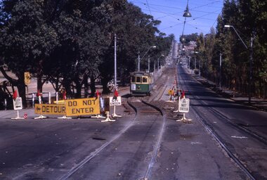
Slide - Set of 3, Keith Kings, 16/03/1968 12:00:00 AM
Set of three 35mm Kodak white cardboard colour slide by Keith Kings of 16 or 17 /3/1968. .1 - W5 834 - on temporary track in Glenferrie Rd during relay looking, south to Kooyong railway station. .2 - photo showing the temporary track and the new 102 lb rail laid out pending welding. .3 - Photo showing W2 418 in Glenferrie Road and trackwork. Route 69" Has the Kooyong Tennis courts on the right hand side. See Keith's slide notes.Keith Kings stamp and number "20-1, 20-2 and 20-3", with details of exposure. .1 - "W5 834 - on temporary track in Glenferrie Rd during relay, south to Kooyong railway station. - 16/3/68" .2 - "Glenferrie Rd relay new 102 lb rail in approximate position in excavation. Ashes rolled as foundation. Temporary track on left. 17/3/68" .3 - temporary track at left being excavated and track drain laid. W2 418 on old track on right. 17/3/68"trams, tramways, glenferrie road, kooyong, trackwork, temporary track, w5 class, w2 class, route 69, tram 834, tram 418 -
 Ballarat Heritage Services
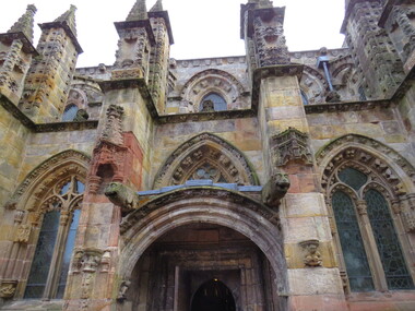
Digital Photograph, Rosslyn Chapel (detail), 10/2016
Sir William St Clair founded Rosslyn Chapel in 1446. It is located south of Edinburgh, Scotland. St Clair hoped to spread intellectual and spiritual knowledge and to ensure his place in Heaven. Rosslyn Chapel is a fine example of stonemason's work. It has many atropaic marks and mason's marks with other symbolism adorning it's structure as well. Excavations in the 1800s uncovered further foundations and building but Sir William died and the larger building was never completed. The village of Roslin (differing spelling) grew up around the estate and chapel due to the large number of craftsmen who helped build it over a 40 year period. William St Clair was the 3rd Prince of Orkney. He died in 1484. His name and the names of his descendants are linked to the beginnings of freemasonry in Scotland. Sir William Sinclair of Rosslyn was granted charters from the Masons of Scotland in 1630.The author Dan Brown who published the Da Vinci Code in 2003 is responsible for the upsurge in interest and visitors at the centre. The Visitor's centre was officially opened in 2012. Colour photographs showing Rosslyn Chapel.rosslyn chapel william st clair freemasonry freemasons scotland -
 8th/13th Victorian Mounted Rifles Regimental Collection
Document
On Canberra Day held on 12 March 1988, a ceremony is conducted to commemorate the relocation of the Commencement Column Monument (also known as the Commemoration Stone) on Capital Hill. The Light Horse Heritage Troop of 8/13 Victorian Mounted Rifles supported the event. The monument was originally designed to have a 20 metre column to signify the Commonwealth. It was to be erected on a hexagonal base comprising six granite blocks, one from each of the original States of the Commonwealth, on the land axis between Capital Hill and Camp Hill. Whilst the column was never completed, the hexagonal base was constructed and, on 12 March 1913, three foundation stones were laid, by the then Governor-General Lord Denman, the Prime Minister Andrew Fisher, and the Minister of Home Affairs the Hon. King O'Malley, to commemorate the founding and naming of Canberra as the national capital. In 1981 the 63 stones making up the monument were removed from Capital Hill and stored prior to the commencement of excavation work for the new Parliament House. Following a Joint Standing Committee recommendation in 1987, the Commencement Column monument is relocated 'on the land axis immediately north of the parade ground associated with the new Parliament House'. Typed Administrative Instruction for A Squadron 8/13 VMR support to Festival of Canberra 10-13 March 1988. Four pages including nominal roll.Light Horse Troop provided mounted guard for the re-naming of Canberra ceremony and participated in Festival Parade. -
 Kiewa Valley Historical Society
Black and White photograph of Road Making Machinery, Kiewa Road Making, 25/08/1938
Construction of the main road from South Tawonga to the Bogong High Plains, to provide access to the construction sites for the new Kiewa Hydro Electric Scheme, was commenced early in 1938, the work being undertaken on behalf of the Commission by the Country Roads Board. For the construction work, the Commission purchased three Caterpillar - model R07 - diesel crawler tractors equipped with Kay Brunerei (Brunner) hydraulically operated trailbuilders (angle dozers). This acquisition resulted from a visit to the United States of America in May, 1937 by the Construction Engineer ( Mr. C.H. Kernot) and Assistant Civil Engineer (Mr. J.F. Douglas) where they saw this relatively new type of equipment in use. With the co-operation of the CRB, the Commission demonstrated the operation of these machines at Fishermen's Bend on 6th April, 1938. They were then sent to Kiewa where they commenced operation towards the end of the month. From South Tawonga, the route led immediately across the Western Branch of the Kiewa River necessitating the construction of a bridge 100 feet long. By the end of 1939, the excavation had been 'opened up' for a distance of 19 1/2 miles (approx. 31 km) and of this length, 10 miles (approx. 16 km) had been surfaced.The purchase and use of this type of mechanical equipment in road making was a huge investment, as prior to this most of the work would have been done manually with the use of picks and shovels. Not only were many months of hard manual labour saved, but a very significant amount of time in providing access to the proposed work sites for the new Kiewa Hydro Scheme. This photo is an excellent reminder of how primitive the early machinery was compared to the present but also represents the forward thinking of the State Electricity Commissions engineers in purchasing such innovative equipment . A black and white photograph showing the type of machinery used for road making in the 1930's. It shows a grader being towed by a caterpillar tractor.On the top left hand corner of the photograph , hand written in black ink is the words 'Kiewa Road Making 25/8/1938'. On the right hand side of the photo has been stamped in blue the Number 1. It has been developed on Velox paper (marked on back of photo) with a gloss finish.road making, state electricity commission, caterpillar tractor, kiewa -
 Kiewa Valley Historical Society
Black and White photograph of Road Making Machinery, Kiewa Road Making 25/08/1938 No. 2, 25/08/1938
Construction of the main road from South Tawonga to the Bogong High Plains, to provide access to the construction sites for the new Kiewa Hydro Electric Scheme, was commenced early in 1938, the work being undertaken on behalf of the commission by the Country Roads Board. For the construction work, the Commission purchased three Caterpillar - model R07 - diesel crawler tractors equipped with Kay Brunerei (Brunner) hydraulically operated trailbuilders (angle dozers). This acquisition resulted from a visit to the United States of America in May, 1937 by the Construction Engineer ( Mr. C.H. Kernot) and Assistant Civil Engineer ( Mr. J.F. Douglas) where they saw this relatively new type of equipment in use. With the co-operation of the CRB, the Commission demonstrated the operation of these machines at Fishermen's Bend on 6th April, 1938. They were then sent to Kiewa where they commenced operation towards the end of the month. From South Tawonga, the route let immediately across the Western Branch of the Kiewa River necessitating the construction of a bridge 100 feet long. By the end of 1939, the excavation had been 'opened up' for a distance of 19 1/2 miles (approx. 31 km.) and of this length, 10 miles (approx. 16 km.) had been surfaced. (see KVHS 0328)The purchase of this type of mechanical equipment in road making was a huge investment, as prior to this most of the work would have been done manually with the use of picks and shovels. Not only were many months of hard manual labour saved, but a very significant amount of time in providing access to the proposed work sites for the new Kiewa Hydro Scheme. This photo is an excellent reminder of how primitive the early machinery was compared to the present but also represents the forward thinking of the State Electricity Commissions engineers in purchasing such innovative equipment.A black and white photograph of road making near Mt. Beauty in 1938. Mount Beauty hills can be seen in the background with cleared land for grazing in the fore ground.Hand printed in black ink at the top of the photograph is 'Kiewa Road Making 25/8/1938'. On the right hand corner has been printed the number 2. It has been printed on gloss Velox paper.road making, state electricity commission, caterpillar tractor, kiewa, secv -
 Kiewa Valley Historical Society
Black and White photograph of Road Making Machinery, Kiewa Road Making 25/8/1938(No. 3 in a series of 8), 25/08/1938
Construction of the main road from South Tawonga to the Bogong High Plains, to provide access to the construction sites for the new Kiewa Hydro Electric Scheme, was commenced early in 1938, the work being undertaken on behalf of the Commission by the Country Roads Board. For the construction work, the Commission purchased three Caterpillar - model R07 - diesel crawler tractors equipped with Kay Brunerei (Brunner) hydraulically operated trail builders (angle dozers)). This acquisition resulted from a visit to the United States of America in May, 1937 by the Construction Engineer ( Mr. C.H. Kernot) and Assistant Civil Engineer (Mr. J.F. Douglas) where they saw this relatively new type of equipment in use. With the co-operation of the CRB, the Commission demonstrated the operation of these machines at Fishermen's Bend on 6th April, 1938. They were then sent to Kiewa where they commenced operation towards the end of the month. From South Tawonga, the route led immediately across the Western Branch of the Kiewa River necessitating the construction of a bridge 100 feet long. By the end of 1939,the excavation had been 'opened up' for a distance of 19 1/2 miles (approx. 31 km.) and of this length, 10 miles (approx. 16 km) had been surfaced.The purchase and use of this type of mechanical equipment in road making was a huge investment, as prior to this most of the work would have been done manually with the use of picks and shovels. Not only were many months of hard manual labour saved, but a very significant amount of time in providing access to the proposed work sites for the new Kiewa Hydro Scheme. This photo is an excellent reminder of how primitive the early machinery was compared to the present but also represents the forward thinking of the State Electricity Commission's Engineers in purchasing such new and innovative equipment.A black and white photograph of a Caterpillar diesel crawler tractor and a hydraulically operated trailbuilder (angle dozer) making a road in the Mt. Beauty area.Hand written in black ink in the top left hand corner are the words "Kiewa Road Making 25/8/1938". On the upper right hand of the photograph has been stamped the number 3. On the back is stamped the word 'Velox' severaly times, which is the make of the photograhic paper. roadmaking, caterpillar tractor, kiewa, state electricity commission -
Bendigo Historical Society Inc.
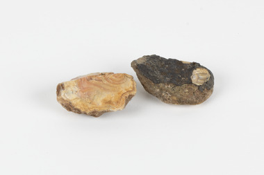
Document - MINING IN BENDIGO COLLECTION: UNEARTHED QUARTZ CRUSHER
Typed notes mentioning the early pioneers of Bendigo Gold Mining. Some of them are: Messrs Ballerstedt, Wittschiebe, Luffsman, Roeder Lazarus, Kock, Hildebrandt, Bruhn,Miller, Annear, Wells, Rae,Jackson, Woodward, Sterry, Burrowes, Thorp, Heine, Holmes, Gould, Allen, Brooks, Watson and Geo Lansell. In 1911 a quartz crusher was unearthed in McCrae Street during excavations at the site of the new St.Kilian's Girls Club Rooms. It was used by the late Mr. James Irons. It was found at a depth of ten feet. Mr. Angus Kennedy, who believed that he manufactured the plant for Mr. Irons, said Mr. Irons used to crush very rich quartz from the Sheepshead Reef, south of the Big Blue Battery. Some years ago, a solid granite stone-crusher was seen at Diamond Hill. It was at the site of the old Diamond Hill Hotel. The Comet Reef was found by Mr. Driesslau, who found gold in an outcrop when he was shooting parrots. Also mentioned is the tunnel that goes right through Diamond Hill.document, gold, mining in bendigo, mining in bendigo, unearthed quartz crusher, messrs ballerstedt, wittschiebe, luffsman, roeder lazarus, kock, hildebrandt, bruhn, miller, annear, wells, rae, jackson, woodward, sterry, burrowes, thorp, heine, holmes, gould, allen, brooks, watson, geo lansell, bendigo advertiser april 28th 1911, st kilian's girls' club rooms, mr james irons, mr angus kennedy, sheepshead reef, big blue battery, diamond hill hotel, victoria proprietary ltd., comet reef, mr driesslau, diamond hill tunnel -
 The Beechworth Burke Museum
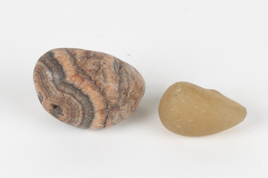
Geological specimen - North Queensland Agates, Unknown
Agate occurs when amygdales (gas pockets) form in the upper levels of basaltic lava flows. If these pockets or bubbles are iniltrated by water bearing silica in solution, the fluid dries and hardens in layers, forming round or egg shaped nodules or geodes within the rocky matrix. Agate is formed of a silica mineral chalcedony similar to quartz. Although relatively common and semi-precious, agate has been prized since at least 1450 BC - an intricately carved agate seal was found in the 2015 excavation of a grave belonging to a Mycenaeum priest or warrior near Pylos in Greece. Agate is also used in jewellery and other decorative or ritual purposes due to its often striking appearance. These specimens originated in North Queensland, which contains noted agate-fossicking regions such as in the area surrounding Forsayth. They were collected in approximately 1852 as an adjunct to the Geological Survey of Victoria. It was donated to the Museum in 1868. Victoria and other regions of Australia were surveyed for sites of potential mineral wealth throughout the 19th Century. The identification of sites containing valuable commodities such as gold, iron ore and gemstones in a locality had the potential to shape the development and history of communities and industries in the area. The discovery of gold in Victoria, for instance, had a significant influence on the development of the area now known as 'the goldfields', including Beechworth; the city of Melbourne and Victoria as a whole. The specimens are significant as examples of surveying activity undertaken to assess and direct the development of the mineral resource industries in Victoria and Australia, as well as the movement to expand human knowledge of earth sciences such as mineralogy and geology in the nineteenth century. Two solid egg-sized pieces of peach/orange toned agate (a common semi-precious chalcedony, similar to quartz) with a striped pattern, embedded in a light and dark brown matrix. geological specimen, geology, geology collection, burke museum, beechworth, agate, north queensland agate, 1852 geological survey of victoria, l. hufer - donor, mineralogy, agate specimen, indigo shire -
 Ballarat Tramway Museum
Newspaper, Geelong Advertiser, "Days of tram travel revived in Ryrie St. dig", "Museum next stop for unearthed tram tracks", 11/06/2002 12:00:00 AM
2124.1 - Photocopy of a newspaper cuttings, titled "Days of tram travel revived in Ryrie St. dig "and from the Geelong Advertiser, 6/6/2002, page 5 written by Peter Begg about the excavation of tram rails / tram tracks in Ryrie St. and the acquisition of these by Tramway Museum Society of Victoria. Quotes Mr. G. Jordan of the TMSV. Has a photo of Brian Bourke, a worker, looking at the tram tracks. Photo by Phillip Stubbs. On the rear of the photocopy is a photo copy of item 2124.2. Photocopied onto an A4 size sheet and has been folded into three. 2124.2 - Newspaper cutting titled "Museum next stop for unearthed tram tracks" from the Geelong Advertiser 11/6/2002, page 10, written by Peter Begg about the recovery of tram tracks in Ryrie St. Geelong and the acquisition of these by the TMSV. Also quotes TMSV Secretary, Mr. Graham Jordan. Item has two photos of Geelong trams - one of trams Geelong 4 and 8 in Ryrie St. and a third unidentified tram with the Geelong Theatre in the background in 1954 and No. 32 running past the T&G Building in Moorabool St.geelong, tram track excavation, tmsv, ryrie st. -
 The Beechworth Burke Museum
Geological specimen - Agate and Quartz pebbles
Agate occurs when amygdales (gas pockets) form in the upper levels of basaltic lava flows. If these pockets or bubbles are iniltrated by water bearing silica in solution, the fluid dries and hardens in layers, forming round or egg shaped nodules or geodes within the rocky matrix. Agate is formed of a silica mineral chalcedony similar to quartz. Although relatively common and semi-precious, agate has been prized since at least 1450 BC - an intricately carved agate seal was found in the 2015 excavation of a grave belonging to a Mycenaeum priest or warrior near Pylos in Greece. Agate is also used in jewellery and other decorative or ritual purposes due to its often striking appearance. Quartz is found all over Australia, including Beechworth in Victoria. It is formed in deep-seated igneous rocks and crystallized through hot aqueous solutions. It can have two forms; Microcrystalline quartz or Crystalline quartz. Microcrystalline quartz is a fine grain quartz where crystalline quartz is often a large crystal. The colour of quartz can vary. These specimens were collected in Victoria in the vicinity of the Burke Museum. Victoria and other regions of Australia were surveyed for sites of potential mineral wealth throughout the 19th Century. The identification of sites containing valuable commodities such as gold, iron ore and gemstones in a locality had the potential to shape the development and history of communities and industries in the area. The discovery of gold in Victoria, for instance, had a significant influence on the development of the area now known as 'the goldfields', including Beechworth; the city of Melbourne and Victoria as a whole.The specimens are significant as examples of surveying activity undertaken to assess and direct the development of the mineral resource industries in Victoria and Australia, as well as the movement to expand human knowledge of earth sciences such as mineralogy and geology in the nineteenth century.Geological specimens of Agate and Quartz respectively; the fist-sized piece of Agate has peach/coral colouring with grey concentric patterning and the smaller piece of quartz is a uniform yellow/orange shade. Existing label: Local pebbles / (agate and / quartz / (yellowish) / egg-shaped). / BB geological specimen, geology, geology collection, burke museum, beechworth, agate, quartz, north-east victoria, indigo shire, geological surveys -
 Ballarat Tramway Museum
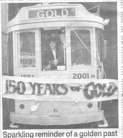
Newspaper, The Courier Ballarat, "Tram study ready to go", "Sparkling reminder of a golden past", "Section torn from Skipton St", 15/06/2001 12:00:00 AM
Yields information about the launch of the Gold Tram and the people involved on the day.Newspaper cutting, page 4, from The Courier, Ballarat, June 15, 2001, headed "TRAMS IN BALLARAT" featuring three different tram stories. Headed "STUDY" and titled "Tram study ready to go", about the consideration of tenders for the study to consider the return of trams to Ballarat, or other form of transport. Quotes Dianne Smith, Ballarat Tourism Executive Director. Headed "GOLD TRAM" and titled "Sparkling reminder of a golden past", about the launch of the Gold Tram 45, by the Mayor, David Vendy the previous day at the tram depot. Quotes Richard Gilbert as president and Cr. Vendy. Features a photograph of Cr. Liz Sheedy and the Mayor standing along side, breaking through the banner ( See Reg. Item 1777). See Reg item 3839 for a colour photograph of the photo of No. 45. Headed "TRACKS" and titled "Section torn from Skipton St" about the excavation of about 50m of track in Skipton St. Ballarat at the intersection with Drummond St. during the reconstruction of the intersection associated with installation of traffic lights and new traffic islands. Quotes Peter Winspur, Secretary. A number of calls were received about the work. See Reg. Item 1778 for photos on the day.ballarat city tramway, gold tram, skipton st, trackwork -
 Bendigo Historical Society Inc.
Map - BENDIGO HISTORICAL SOCIETY COLLECTION: EAGLEHAWK MINE MAP
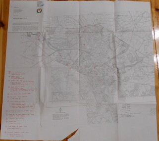
Base map Australian map grid of Eaglehawk area. Map has letter attached from the Department of Conservation, Forests and Lands, 22 March, 1990, addressed to Felicity Kingerlie, BHS, requesting information regarding the historic mining sites marked on the map. Sites marked are: A. Golden Age Mine, engine mountings present B. Johnson's No. 2 Mine, engine mountings, old boiler foundations C. Johnson's No. 1 Mine, mullock retaining wall made from sandstone, engine mountings, remains of old building demolished? D. Toma's Eucalyptus Factory, old boiler still there, boiler shed, chimney (remnants of) outlet drain, distilling vats, dam, remnant of winch. E. New Argus Mine,mullock heap F. New Moon Mines Dams (1) stone walls G. North Lightning Hill Mine, engine mountings, quartz retainer wall, Pascoe and Simmons open cuts and other open cuts here too H. New Prince of Wales Mine and Poppet Head I. Quarry site for stone, excavation (for miners cottages in Clarke Street) J. Lancashire open cut mine K. Virginia Hill (cynaide vats etc) L. South Prince of Wales mine, now capped and fenced M (possibly ) Catherine United Mine, engine mountings, battery mountings?bendigo, mining, eaglehawk mines -
 Ballarat Tramway Museum
Photograph - Black & White Photograph/s, Nov. 1965
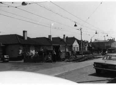
Set of seven Black and white photographs on Kodak paper for the arrangements and work for the track reconstruction of Commercial Road Prahran. Series of photos show Down track already complete. Probably second half of October or early November 1965. (Electric Traction 11/65) (Unusual to have two jobs at once - see Hawthorn Rd - Reg item 1421). Series show the construction method. Temporary track formed by progressively lifting original track on to side of road each night. Relaying then follows progressively. Pictures show almost completed section (1423.1 &2), concreting (1423.3), new rails in situ (1423.4&5),newly moved track (1423.6&7), excavation taking place (1423.7) 1421.1 - Commercial Rd looking west at Charles St showing ramp to temporary city bound track. 1423.2 Ditto - just west of Charles St. 1423.3 Ditto - corner Perth St on left, Hyland St on right. 1423.4 Ditto - between Perth and Donald Sts. Scrubber car No 9. 1423.5 Ditto - looking east between Perth and Donald Sts. - W5 723 on new track, W5 722 on temporary track. 1423.6 Ditto - looking east. Max Hotel on corner of Donald St. 1423.7 Ditto - looking east at corner of Alfred St. Scrubber car No 9. See P.Winspur note with item 1418.trams, tramways, commercial road, reconstruction, trackwork, mmtb, tram 9, tram 723, tram 722 -
 Flagstaff Hill Maritime Museum and Village
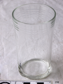
Domestic object - Glass
The art of making glass can be traced back to 2600 BC in Mesopotamia. Egyptians practised making glass around 2500 BC. Artificial glass first appeared in the Egyptian or the Mesopotamian civilization, whereas they used tools made out of volcanic glass obsidian in the Stone Age. Ancient China, however, discovered how to make glass a little later. Glass beads are known to be one of the earliest products made out of glass. Their creation is thought to be primarily accidental. In the later Bronze Age, glassmaking came to a halt. Glass was a luxury material back then. Archaeological excavations suggest the use of glass in England during the middle ages. In the 10th century, stained glass found a place in cathedrals and windows of palaces. After the Renaissance, architectural methods changed substantially, leading to a decrease in stained glass as a building material. Domestic use of glass increased following the industrial revolution. Vessels, glass windows, and glass beads gained popularity in Europe during this period. During the 19th century, many people preferred glass windows and doors as a decorative option. In the late 19th century, some designers brought back stained glass in decorative windows. It was during this period that Mr Tiffany discovered several methods to make domed glass handicrafts. People discovered the true versatility of using glass as a building material only in the 20th century. With glassmaking technology receiving an industrial boom, you could produce several different types of glass. Toughened glass, laminated glass, bulletproof glass, and smart glass all boosted the use of glass in buildings. Today, several skyscrapers, small and big homes, and offices use glass in almost all aspects of construction and design. https://www.aisglass.com/glass-made-step-step-process/The invention and development of glass, both as domestic items and in building, has been nothing short of revolutionary. Prior to the use of glass for windows, the interior of buildings were extremely dark, even during sunny days. The use of glass domestic objects, that could be easily washed, led to improved hygiene.Cylindrical drinking glass with stepped relief around lipNoneflagstaff hill, warrnambool, shipwrecked-coast, flagstaff-hill, flagstaff-hill-maritime-museum, maritime-museum, shipwreck-coast, flagstaff-hill-maritime-village, glass -
 Flagstaff Hill Maritime Museum and Village
Functional object - Water Pump, Goulds Manufacturing Co, 1915-1925
Gould manufacturing company was founded in 1848 at Seneca Falls, New York when Seabury S. Gould purchased an interest in Downs, Mynderse & Co. and the firm became Downs & Co. Wooden pumps were produced at the time in an old cotton factory building. In 1869, the name of the company was changed from Downs & Company to Goulds Manufacturing Company. Seabury S. Gould was regarded as a man of unusual vision, and as the founder of Goulds Manufacturing Company he was keen to start producing cast iron pumps. An iron pump, he believed, would overcome all the disadvantages of a wooden pump. It would be strong and efficient and provide fresh flowing water for the pioneers. He ran the company until after the American Civil War and because Goulds Manufacturing had a foundry, they also produced all kinds of cast iron products such as corn shellers, bells, sad irons, sinks, tools, and a line of fire engines. From 1848 to 1964 a Gould family member had always been President of the company. However, the company ownership in 1964 was transferred from family-owned stock to public offerings and employee ownership of stock. The subject item called the "N e w Deluge" was an improved bilge pump for vessels having not more than 25 feet depth of hold. It was also used by contractors for pumping out excavations and was well adapted for irrigation use. This hand pump was designed to be used where a hand pump of large capacity was desired. Goulds made many different types of pumps to suit differing pumping situations such as. Well Pumps, Hydraulic Rams, Diaphragm Pumps, Tank Pumps, Sprayers and Small Capacity Power rumps. Goulds Triplex, Centrifugal, Rotary and Deep Well Power Pumps The subject item was first introduced to the market in the Goulds catalogue of 1915 and became a very popular pump used in Australia and the USA. It is manufactured by a company still trading today with offices in Australia and many other countries.Hand Pump cast iron with long reversable pumping lever and cylindrical casing there are 4 metal holes for fastening to floor surface. Painted black. Embossed "NEW DELUGE" "- - -" and "No 16" or "No 18".warrnambool, flagstaff-hill, flagstaff-hill-maritime-museum, maritime-museum, shipwreck-coast, flagstaff-hill-maritime-village, pump, hand pump, goulds manufacturing -
 Flagstaff Hill Maritime Museum and Village
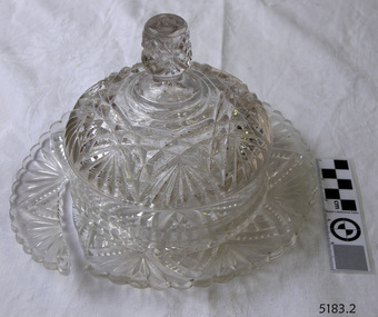
Domestic object - Butter Dish
The art of making glass can be traced back to 2600 BC in Mesopotamia. Egyptians practised making glass around 2500 BC. Artificial glass first appeared in the Egyptian or the Mesopotamian civilization, whereas they used tools made out of volcanic glass obsidian in the Stone Age. Ancient China, however, discovered how to make glass a little later. Glass beads are known to be one of the earliest products made out of glass. Their creation is thought to be primarily accidental. In the later Bronze Age, glassmaking came to a halt. Glass was a luxury material back then. Archaeological excavations suggest the use of glass in England during the middle ages. In the 10th century, stained glass found a place in cathedrals and windows of palaces. After the Renaissance, architectural methods changed substantially, leading to a decrease in stained glass as a building material. Domestic use of glass increased following the industrial revolution. Vessels, glass windows, and glass beads gained popularity in Europe during this period. During the 19th century, many people preferred glass windows and doors as a decorative option. In the late 19th century, some designers brought back stained glass in decorative windows. It was during this period that Mr Tiffany discovered several methods to make domed glass handicrafts. People discovered the true versatility of using glass as a building material only in the 20th century. With glassmaking technology receiving an industrial boom, you could produce several different types of glass. Toughened glass, laminated glass, bulletproof glass, and smart glass all boosted the use of glass in buildings. Today, several skyscrapers, small and big homes, and offices use glass in almost all aspects of construction and design. https://www.aisglass.com/glass-made-step-step-process/The invention and development of glass, both as domestic items and in building, has been nothing short of revolutionary. Prior to the use of glass for windows, the interior of buildings were extremely dark, even during sunny days. The use of glass domestic objects, that could be easily washed, led to improved hygiene.Moulded patterned glass butter dish. Base has been broken.None.flagstaff hill, warrnambool, shipwrecked-coast, flagstaff-hill, flagstaff-hill-maritime-museum, maritime-museum, shipwreck-coast, flagstaff-hill-maritime-village, glass, kitchen item, butter