Showing 11556 items matching " map"
-
 Ballarat Tramway Museum
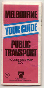
Map, Ministry of Transport, "Melbourne Public Transport Map" - "No. 9", 1979
Pocket size - folded - public transport map of Melbourne, printed in colour on paper, showing public transport services in greater Melbourne and an index of localities. The Central zone area shown in detail. On the rear, route numbers and line maps of tram routes and train lines or services. Includes private bus routes. Printed for the Ministry of Transport. Issue No. 9. Dated 1979.trams, tramways, melbourne, map, routes -
 Ballarat Tramway Museum
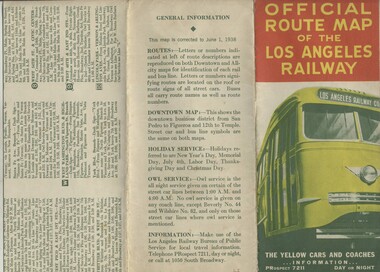
Map, H.P. Noordwal, "Official Route Map of the Los Angeles Railway", Jun. 1938
A (12 section) fold out map of street car (tram) and bus services for Los Angeles, dated June 1, 1938, showing all LAR (Los Angeles Railway) streetcar and coach (tram and bus) services, Pacific Electric lines within area, detailed "downtown" map, route descriptions and points of interest. Record images added 20/8/2013.Three terminus have been marked with pencil "X". On rear car, next to object number is a symbol looking like a "H & S" merged together.trams, tramways, los angeles, street cars, map -
 National Vietnam Veterans Museum (NVVM)
Map
A details map detailing Nui Dat. This map is a Special Edition 2map, nui dat -
 Vision Australia
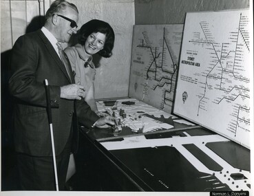
Photograph - Image, Jack Chamberlain reading a tactile map of Sydney with Val Hickey, 1970?
Jack Chamberlain (P.R.O.) feeling a relief map of Sydney's CBD, with Val Hickey (Publicity Officer).2 x B/W photographs of man looking at transit map4/70414 and 6/70414royal blind society of nsw, jack chamberlain, val hickey, maps -
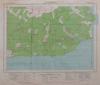 Federation University Historical Collection
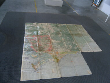
Map, Mallacoota, 1942, 1942
Printed colour map on paperThis map is an official document, if found, it must be handed in to the nearest military headquarters or police stationmallacoota, bass straight, cape evarard, cann river, genoa river, disaster bay -
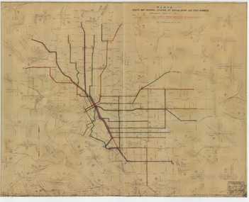 Melbourne Tram Museum
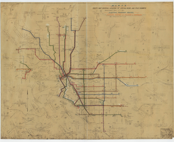
Drawing, Melbourne & Metropolitan Tramways Board (MMTB), "Route Map showing location of special work and pole numbers" "All night tram routes in colours", late 1941
Map of the system shown at two inches = 1 mile. Drawing No. P5799. Shows crossovers, track layouts at junctions, signal cabins roads, railways, and stations. Originally signed by Perway Engineer - 20/12/1940, though originally drawn in 1922. Has been marked up in colour pencil to show the all-night routes and the individual services. The plan shows the lines to Maribyrnong Munitions works along Cordite Ave and Wests Road and the track from Moonee Ponds to Union Road, opened in July 1941, but not the extension to Essendon Airport built in 1942.Demonstrates a detail drawing of Melbourne tramways, junctions and pole numbers.Drawings - dyeline cloth-backed print - titled - "Route Map showing the location of special work and pole numbers" and subtitled - "All night tram routes in colours". trams, tramways, mmtb, trackwork, tramways, junction, map, world war 2, night trams -
 Ballarat Tramway Museum
Map, Ballarat Litho & Printing Co, "Electoral Map of Ballarat", 1920's?
Map showing the electoral boundaries of Ballarat - State? - possibly early 1920's. Has been marked up in blue pencil for electric and horse tram routes around Ballarat, along with names of terminals, depot, and other points of interest. Shows horse trams lines in Macarthur St and Armstrong St. Also has in pencil, approximate location of the railway to Buninyong. Map shows location of Showgrounds (old location), Hospital for epileptics, abattoirs, but does not show Ballarat North Railway Workshops. Title Block "Ballarat Litho & Ptg. Cos. / Electoral Map of / Ballarat / Scale 20 chains to One Inch" To be stored with minimal folding.trams, tramways, map, ballarat, horse trams -
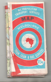 Melbourne Tram Museum
Map, Ministry of Transport, "Melbourne Transport Services Map - Tram, Train and Bus Services", c1974
Fold out map (27 sections 9 across x 3 deep), coloured of Melbourne's Tram and Bus routes, route numbers, rail lines, detailed for the central part of Melbourne and insert section for Frankston. On rear description of routes, private bus routes and map of Melbourne metro lines. Has contact details for bookings and lost property etc. Priced 15c Inscription dates the map as 1974. Two copies held.On front cover in ink "#3" in top right hand corner and "4 G 33 1974" along bottom edge of the first copy.trams, tramways, melbourne, map, tram & bus services, railways, mmtb, minister for transport -
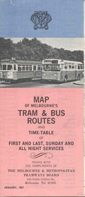
 Melbourne Tram Museum
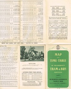
Map, Melbourne & Metropolitan Tramways Board (MMTB), "Map and timetable of Melbourne Tram and Bus Services" - March 1952", Mar. 1952
Fold out map (10 sections), coloured of Melbourne's Tram and Bus routes, route numbers, rail lines, municipalities boundaries and location of major places of interest. Titled - "Map and timetable of Melbourne Tram and Bus Services" - May 1952". At base of map - timetable of all night trams and bus services. On rear index to routes, 1st and last services, time of Sunday am services, Latrobe St. services and photo of Wattle Park. Dated March 1952 - Bourke St shown as bus. See Reg Item 413 for the May 1956 version. Very high resolution scans held. See also Reg Item 3720 for a MMTB Map of the same era.trams, tramways, melbourne, map, tram & bus services, all night services, mmtb -
 National Vietnam Veterans Museum (NVVM)
Map
Highly detailed map of Vietnam on parchment from Fwouc Tho Province. Map is waterproof.map, peter lewis -
 Melbourne Tram Museum
Drawing, Melbourne & Metropolitan Tramways Board (MMTB), "Route Map showing location of special work and pole numbers" "Electric Tramway Routes - showing routes in colours and numbers", late 1941
Map of the system shown at two inches = 1 mile. Drawing No. P5799. Shows crossovers, track layouts at junctions, signal cabins roads, railways and stations. Originally signed by Perway Engineer - 20/12/1940, though originally drawn in 1922. Has been marked up in coloured pencil to show the routes and route numbers. The plan shows the lines to Maribyrnong Munitions works along Cordite Ave and Wests Road and the track from Moonee Ponds to Union Road, which opened in July 1941, but not the extension to Essendon Airport built-in 1942. See Reg Item 1561 for a 1963 version and 1683 for a 1987 versionDemonstrates the use of a MMTB drawing to show tram routes and their route numbers at the time.Drawings - dyeline cloth backed print - titled - "Route Map showing location of special work and pole numbers" and subtitled - "Electric Tramway Routes - showing routes in colours and numbers". trams, tramways, mmtb, trackwork, tramways, junction, map, world war 2 -
 Melbourne Tram Museum
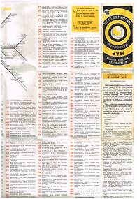
Map, Melbourne & Metropolitan Tramways Board (MMTB), "Map and timetable of Melbourne Tram and Bus Services" - May 1956", May. 1956
Fold out map (10 sections), coloured of Melbourne's Tram and Bus routes, route numbers, rail lines, municipalities boundaries and location of major places of interest. Titled - "Map and timetable of Melbourne Tram and Bus Services" - May 1956". At base of map - timetable of all night trams and bus services. On rear index to routes, 1st and last services, time of Sunday am services, LaTrobe St. services and photo of Wattle Park. Dated May 1956. Note the inset map shows Bourke St as a bus. Three copies held. 413.1 - as for above but with a pasted over section titled "Time table of all - night bus services" on the base of the map replacing the all night tram and bus services. Dated 3/7/1957. Copy from donation of Gary Butler added 3/12/15. See Reg Item 2300 for the March 1952 version.trams, tramways, melbourne, map, tram & bus services, all night services, mmtb -
 Melbourne Tram Museum
Map, Ministry of Transport, "Metropolitan Transport Services Map - Melbourne Tram, Train and Bus Services", 10/1971
Fold out map (27 sections 9 across x 3 deep), coloured of Melbourne's Tram and Bus routes, route numbers, rail lines, detailed for the central part of Melbourne. On rear description of routes, private bus routes and map of Melbourne metro lines. Has contact details for bookings and lost property etc. Priced at 10c. Launched in a newspaper advert 26/10/1971. Has map scale in miles. 2nd copy added 16/7/2014On front cover in ink "#1" in top right hand corner and "4 G 33" along bottom edge.trams, tramways, melbourne, map, tram & bus services, railways, mmtb, minister for transport -
 Melbourne Tram Museum
Map, Ministry of Transport, "Melbourne Transport Services Map - Tram, Train and Bus Services", 1977
Fold out map (27 sections 9 across x 3 deep), coloured of Melbourne's Tram and Bus routes, route numbers, rail lines, detailed for the central part of Melbourne and insert section for Frankston. On rear description of routes, private bus routes and map of Melbourne metro lines. Map No. 7, 1977. Has contact details for bookings and lost property etc. Priced 20c. 1977, route 59 showing as terminating opposite Essendon Airport.On front cover in ink "" in top right hand corner and "4 G 33 " along bottom edge.trams, tramways, melbourne, map, tram & bus services, railways, mmtb, minister for transport -
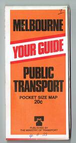
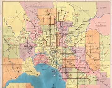
 Melbourne Tram Museum
Document, Ministry of Transport, Melbourne Public Transport Map - No. 12, 1982
Map No. 12 - Includes description of tram and bus routes, private bus routes. On the front cover is composite image of Melbourne public transport vehicles. Has contact details for bookings and lost property etc and how to use the map. Priced at 40c, issue No. 12 of c1982. Has details of the then new Travelcard ticket system. Yields information about Melbourne public transport services in 1982.Fold out map (36 sections 9 across x 4 deep), "Public Transport Map", coloured of Melbourne's Tram and Bus routes, route numbers, rail lines, detailed for the central part of Melbourne and the outer Metropolitan services.tramways, melbourne, tram services, bus services, railways, travelcard -
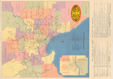
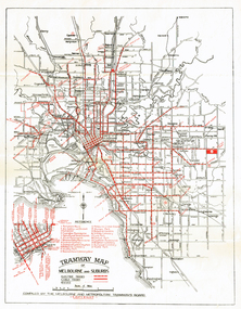
 Ballarat Tramway Museum
Map, Survey and Mapping for MMTB, "Map of Melbourne's Trams and Bus routes and all night services", Jan. 1967
Fold out sheet coloured map, 12 portions or folds, - title - "Map of Melbourne's Trams and Bus routes and all night services" map shows trams lines, route numbers, terminal points, bus routes, railway lines, blow up of city area with places of interest and key. On rear details, places of interest, suburb index, index to routes, first and last services, Sunday am services, all night bus services and locations of depots and head office. 2nd copy added 11-8-2006. Images of document - scanned to A3 size and overlapping added 30/10/13 On rear "out of date" stamp and 1 "cancelled" stamp - red ink.trams, tramways, melbourne, map, tram & bus services, all night services -
 Melbourne Tram Museum
Map, Melbourne & Metropolitan Tramways Board (MMTB), "Tramway Map of Melbourne and Suburbs", c1939
Folded map (4 x 2) by Melbourne and Metropolitan Tramways Board, c1939, of Melbourne tramways, showing tram routes (cable, electric and VR), bus routes, railway lines, major points of interest and major streets. No printing or information on the rear. Once part of another document with remnants of glue on the rear top left hand edge. See Reg Item 801 for a 1927c map.trams, tramways, map, mmtb, vr, cable trams -
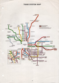 Melbourne Tram Museum
Map, The Met, "Tram System Map", c1990
Tram system map published by The Met to show the various Melbourne tram routes, route numbers, principal road names, suburbs and tram routes within the Central Business District.Provides information about Melbourne tram routes c1990Printed A4 full colour sheet with four punch holes on left hand side.tramways, melbourne, the met, map, tram routes, routes -
 Ballarat Tramway Museum
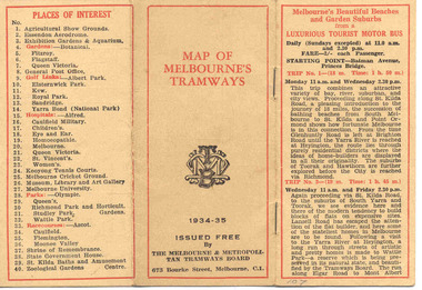
Map, Melbourne and Metropolitan Tramways Board (MMTB), "MMTB Map of Melbourne Tramways 1934-5", 1934
Demonstrates methods of giving information to visitors to Melbourne and yields information about tram services at the time in Melbourne.Very small pocket sized timetable and map book, consisting of 2 octavo cards stapled and folded into 12 pages consisting of three pages of bus and tram round trips, 3 center pages for map of electric and cable trams, route numbers and interest points. Map printed in 4 colours. 4 pages index to routes and first and last trams to City and from City. Also gives points where suburban routes are intersected by City routes. One page devoted to places of interest. All printing in black with red headings and highlights.trams, tramways, mmtb map, mmtb, timetables, tourist trips, map -
Whitehorse Historical Society Inc.
Map, Nunawading Shire, 1892
Photocopy of an enlargement of map of Shire of Nunawading showing landowners in 1892.Photocopy of an enlargement of map of Shire of Nunawading showing landowners in 1892. Covers Middleborough Road to Ringwood boundary. One map (Blackburn) from north of Whitehorse Road to Highbury Road, 2nd map (Mitcham) Bulleen to south of Canterbury Road; 3rd map Whitehorse Road to Highbury Road.Photocopy of an enlargement of map of Shire of Nunawading showing landowners in 1892. maps, shire of nunawading, blackburn, blackburn south, nunawading, forest hill, vermont, mitcham, vermont south -
 Melbourne Tram Museum
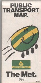
Map, Metropolitan Transit Authority (MTA), "Public Transport Map", c1984
Fold out map (36 sections 9 across x 4 deep), "Public Transport Map", coloured of Melbourne's Tram and Bus routes, route numbers, rail lines, detailed for the central part of Melbourne and the outer Metropolitan services. Includes description of tram and bus routes, private bus routes. On the front cover is The Met's Buzz symbol and their logo. Has contact details for bookings and lost property etc and how to use the map. Priced at 69c, issue No. 13 of c1984. Two copies held.trams, tramways, melbourne, map, tram & bus services, railways, the met, neighbourhood tickets -
 Eltham District Historical Society Inc
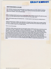
Map, Geoff Braithwaite, Braithwaite ma0p of Eltham circa 1920
A3 photocopy of hand drawn map of Eltham created by Geoff Braithwaite (1914-2008) of his memory of the township about 1920. It includes names of streets and property owners. Folder of information on Geoff Braithwaite Includes A3 photocopy of hand drawn map of Eltham with coloured shading of Eltham in 1920s and 1930sharry gilham collection, eltham, 1920, geoff braithwaite, map, smart family cottage, eltham cemetery, flora caroline braithwaite (nee gamble), geoffrey braithwaite -
 Ballarat Tramway Museum
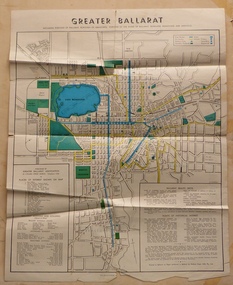
Map, Greater Ballarat Association and George Netherway, "Map of Ballarat", c1950
Yields information about Greater Ballarat, including trams, buses, locations and streets. Has a strong association with George Netherway.Four colour map of Ballarat, showing streets, places of interest, Parks, tram routes, bus routes, railway lines, prepared by G. C. Netherway, Greater Ballarat Association. Shows suburbs names, location of places of interest, some development north of Howitt St, in Wendouree. Map is part diagrammatic and is not entirely to scale. Includes the Lake Wendouree Rowing course On rear is a road map of the Ballarat area, lists of statistics, beauty spots, look outs, art and culture, points of historical interest, industrial products and recreation. Printed by Waller & Chester on paper produced by Ballarat Paper Mills Pty Ltd. See Reg item 2074 for photographic image of this version of the map. See Reg Item 2776 for another version of this map. Contained originally within Reg Item 5507 at the back of the binder. For items see btm5507 loose items list.pdf John Whiting in an email of 17-9-2021 noted: The rowing course along Lake Wendouree is noted, so perhaps this map is post 1956? The Mt Pleasant tram line is shown to terminate at Morton St, not Cobden St (which of course is incorrect) Someone's come along and drawn in black ink the branch of the View Point tram line!trams, tramways, ballarat, tram routes, bus routes, map, lists -
 Ballarat Tramway Museum
Map, Compiled by MMTB, "Map and timetable of Melbourne Tram and Bus Services" - May 1956, May. 1956
Fold out map (10 sections), coloured of Melbourne's Tram and Bus routes, route numbers, rail lines, municipalities boundaries and location of major places of interest. At base of map - timetable of all night trams and bus services. On rear index to routes, 1st and last services, time of Sunday am services, Latrobe St. services and photo of Wattle Park.trams, tramways, melbourne, map, tram & bus services, all night services, mmtb -
 Federation University Historical Collection
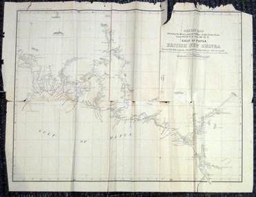
Map, British New Guinea, 1893, 1893
The map was surveyed by ship compass, distances by estimation or rate of launch by officers of the Government ; supervised and compiled by J.B. Cameron, G.S. March 1893. This map was in the possession of Charles Carty Salmon (1860-1917), politician, born on 27 July 1860 at Amherst, Victoria. (http://adb.anu.edu.au/biography/salmon-charles-carty-8328 ) Although living in Melbourne Charles Carty Salmon kept property at Talbot. The property was leased, then purchased by the donor's family. A copy of "The Goulburn Weir and its Dependent System of Works" and this map (in a government envelope addressed to Salmon) were left at the property. See http://nla.gov.au/nla.map-rm1894-1 .1) Sketch map showing the rivers and an outline of the coast from Long. 144?30'E. to Long. 146?30'E. Gulf of Papua British New Guinea Scale [ca. 1:316,800]. .2) Large envelope addressed to The Hon Charles Carty Salmon M.P., Talbot, Victoria. The map was folded and stored in this envelope. Map extending from Port Bevan to Kaikavau Pt, showing rivers and notes on soil and vegetation. Relief shown by hachures and spot heights. Also available in an electronic version via the Internet at: http://nla.gov.au/nla.map-rm1894-1 .1) "Enclosure in Despatch No. 32 of 3rd May 1893 - Appendix G.". "Map no. 4 British New Guinea report 1892-93". .2) "This envelope can only be lawfully used by Government Officials on public business. Any use by Officials on private business, or by others under any circumstances, is punishable." "Commonwealth Celebrations. General Secretary's Office, Melbourne."carty salmon, charles carty salmon, new guinea, j.b. cameron -
 Greensborough Historical Society
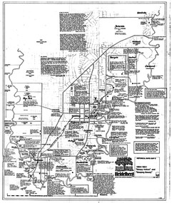
Map, Heidelberg: Historic River Landscape Assessment. Historical maps. Map D 1864 -1901 "Sleepy Hollow" and "Sleeping beauty", 1985c
Geographical area of c. 35 sq. kilometres marked with physical features such as major roads, rivers, vegetation and properties, with locations and notes on the increasing number of farms, orchards and vineyards that had been developed in addition to pastoral runs. Bounded by Shire of Diamond Valley to the North, Darebin Creek to the West, and Plenty River to the East.Black and white sketch on white paper. Second copy 600 x 430 cm printed in black on semi-opaque paperheidelberg, heidelberg - maps -
 Greensborough Historical Society
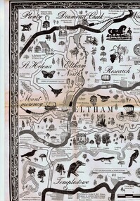
Map, George W. Bell, Eltham Warrandyte and environs: a visitor's guide map: centenary souvenir. 2nd ed, 1994c
Tourist guide to historic and other features in the Eltham Warrandyte area and environs, A2, black & white, folded 3 times to A5, printed on one sidewarrandyte, eltham, st helena, montmorency -
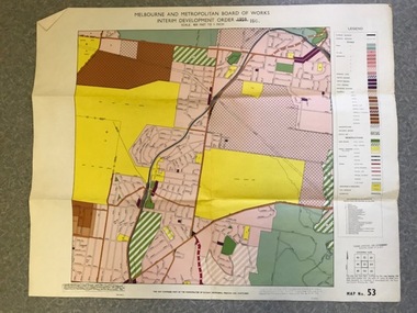 Greensborough Historical Society
Map, Melbourne and Metropolitan Board of Works Interim Development Order 1961 Map No. 53, 27/09/1961
Denotes Zones and Reservations comprising part of the municipalities of Eltham, Heidelberg, Preston and Whittlesea, approved 27.9.61. Includes Mont Park Hospital and Watsonia Military Camp.Colour plan Date printed on plan (1959) has been over stamped with 1961. Also stamped with Government Gazette date of 27.9.1961. "Scale 800 feet to 1 inch"greensborough, watsonia -
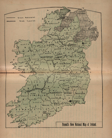 Ballarat and District Irish Association
Map, Panell's New National Map
-
 Brimbank City Council
Map, Keilor General Cemetary Map